Walk #123: Mile End to Dartford
 |
 |
|
General Data
| Date Walked | 18/11/2000 |
| County | London, Kent |
| Start Location | Mile End |
| End Location | Dartford Station |
| Start time | 08.39 |
| End time | 14.46 |
| Distance | 15.0 miles |
| Description | This was a lovely memory-provoking walk through the east end to Greenwich led to an entertaining but fairly boring walk along the unbelievably straight A207 road to the east. |
| Pack | Today I carried no pack (I just wore my coat and carried a water bottle). |
| Condition | I have a slight hot-spot on the back of my right heel where the trainers had a slight bump in the lining. I also had some trouble with my lower back on the left hand-side, which was causing slight problems when I walked. Otherwise I was okay, and could easily have walked further. |
| Weather | The day started off sunny with a little wind. It was quite cold, but not too bad for the time of year. After midday it started to cloud over, and near the end of the walk it started spitting before raining lightly for about twenty minutes, but not enough to get me in the least way wet. |
| OS map | Landranger number 177 (East London, Billericay & Gravesend) and London A to Z |
 |
Map of the walk
Maps courtesy of Google Maps. Route for indicative purposes only, and may have been plotted after the walk. Please let me have comments on what you think of this new format. For a detailed table of timings for this walk, please see the table file.
Notes
This was a slightly strange walk through the centre of London, and could be split into two distinct parts; the first from Mile End to Greenwich Park being through areas of London where I used to live, and the second being along the arrow-straight A207 eastwards out of London. For three or four years in the early nineties I had very close connections with the east end of London; I lived in several places in the Mile End and Isle of Dogs areas, and a couple of girlfriends of mine lived in the area. Hence I have many happy memories of the area, and the route of the walk was heavily influenced by my memories. For instance the first part of the walk from Mile End to Prestons Road on the eastern side of the Isle of Dogs followed a route that I used to walk when I lived in a flat just off Prestons Road.
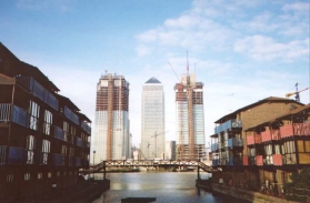
The whole Isle of Dogs area has changed since I lived there; although it was becoming increasingly gentrified back in '93 and '94, this process has seemingly sped up with some of the run-down areas that I used to know having been pulled down and replaced with housing or offices. A typical sign of this increasing rate of change was Canary Wharf itself, rising up alongside the existing tower are two other tower blocks which look as if they are going to be at least as tall as the main tower. Unfortunately this change also means that some of the areas that I used to love - in particular some nooks and crannies that few people knew about - have now gone, replaced in places with some extraordinarily bland housing or office complexes. It also appears that some of the locals that comprised the character of the Isle are still resent, and with improved living conditions.
When I lived on the Isle of Dogs it was well known that the so-called 'yuppiefied' areas - in particular the area around Canary Wharf - were ghost towns in the evening and at weekends when none of the office workers were present. I could not tell if this situation had improved since I lived there, but I am hopeful given the vast increase in accommodation on the Isle, even if that accommodation is not affordable for the existing residents of the Isle.
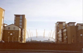
Another symbol of the vast change that as occurred in the east end was clearly visible for the first three or four miles of the walk, and that was the great monument to ill-advised area regeneration which is the Millennium Dome. More words have been written on this edifice than could possibly be justified, but however much I dislike it - for being a waste of money, for being in the wrong location and for the utter crassness of the exhibits held within - it is a very impressive structure, if only on it's scale. It is large. When I first saw it when walking along Prestons Road on he east side of the Isle of Dogs my breath was momentarily taken away. Not as much as a lovely view from a mountaintop, granted, or as much as the Forth road and rail bridges did a couple of months ago, but nonetheless it was impressive.
The Green Bridge at Mile End was also quite impressive. Running alongside the Regents Canal is a park, Mile End Park. This runs from Limehouse Basin in the south up to Victoria Park in the north, and is interrupted in places by roads. One of the biggest of these was the Mile End Road, which essentially split the park into two, with a more park-like southern section and a run-down northern half. The Green Bridge is a large bridge over the Mile End Road that carries the park over the road, and is thus covered in shrubs, grass and trees. I liked the idea as soon as I heard of it, and I must say that I am fairly impressed with the results.
The rest of the walk eastwards from Greenwich Park was fairly boring, but nice nonetheless. Many walkers do not like city walking, but I quite like it as a variation on country walking. Although you do not get the same highs as being out in the hills and scaling the summits, you do nonetheless see many items of interest. One such today was a sign in a churchyard next to Shooters Hill Road on Eltham Common was a stone showing the distance from the church to London Bridge and one of the First World War battlegrounds. Very emotive stuff.
This walk has now got me into Kent, and will allow me to progress towards the south coast. The next walk I shall do in this area will be from Dartford south along the River Darent Trail to Sevenoaks, and then onto Tunbridge Wells; I shall also progress eastwards to Rochester, Canterbury and then Dover.
Directions
Leave Mile End tube station and turn left along the Mile End Road. After a very short distance you reach a set of traffic lights. Turn left down Burdett Road, but before you do so have a look at the impressive Green Bridge that crosses the Mile End Road on the other side of the junction.
Continue on down Burdett Road, under a railway bridge and over the Limehouse Cut Canal before reaching the junction with the A13 East India Dock Road. Turn left down this road and continue along it until you reach All Saints Dockland Light Railway station. Continue past the station and turn right immediately past a very attractive church down Bazeley Street.
At the end of Bazeley Street turn left down Poplar High Street for a short distance past some shops. At the end of the Street cross over Cotton Street and turn right to find a pedestrian underpass taking you under the A1261 Aspen Way and the Docklands Light Railway Beckton Branch. This footpath comes out on Preston's Road on the Isle of Dogs.
Turn right down Preston's Road and follow the footpath alongside the large retaining wall of Poplar Dock and past one pf the ventilation shafts for Blackwall Tunnel - which looks like an oversized mushroom - on the left. Continue past another tunnel ventilation shaft on the right - this time for the Jubilee Line Extension's tunnel under the Thames and over the Blue Bridge, which is now the only access into the docks on the Isle of Dogs.
Continue off the bridge and on to a roundabout. Here take East Ferry Road which leads off the roundabout to the southwest. Continue down this road past the London Arena and an Asda Supermarket. When East Ferry Road ends at the southern end of the Isle of Dogs turn left down Manchester Road, and then just before the entrance to the Dockland Light Railway's Island Gardens station turn right and head to the entrance of the Greenwich foot tunnel in the corner of Island Gardens. From the gardens a wonderful view - as famously painted by Canaletto - of the Royal Navy College and Greenwich Park is available, and should be viewed before entering the tunnel.
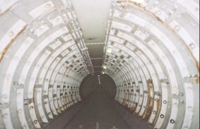
Enter the tunnel and descend the circular flights of steps, or take the lift if you want to experience their lovely interior. Go under the tunnel and ascend to the surface on the southern side of the River Thames beside the Cutty Sark in Greenwich. Head south past Cutty Sark along King William Walk and cross the busy Romney Road. Continue ahead and enter Greenwich Park via some very ornate gates. Head through the park and up the hill to the Greenwich observatory. From here take in the views across London before heading along Blackheath Avenue to the southern edge of the Park.
Leave the park at Blackheath Gate and turn left, following Charlton Way along the southern edge of the park. Round a bend this becomes Vanbrugh Park Road, and across a roundabout it becomes Old Dover Road. This then crosses the A102(M) motorway before joining the A207 Shooters Hill Road. The rest of the walk is a very simple one following the A207 as it heads straight north-southeastwards into Dartford.
Distances
| From | To | Distance (m) | Ascent (ft) | Descent (ft) |
|---|---|---|---|---|
| Mile End | Greenwich | 4.2 | 10 | 43 |
| Greenwich | Welling | 5.9 | 469 | 322 |
| Welling | Dartford | 4.9 | 171 | 312 |
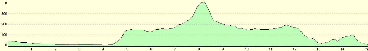
This makes a total distance of 15.0 miles, with 650 feet of ascent and 677 feet of descent.
For more information on profiles, ascents and descents, see this page
Transport
There are regular train services from Dartford into central London, with intermediate stops at Greenwich, Lewisham, Blackheath, Kidbroke, Eltham, Falconwood, Welling, Bexleyheath and Barnehurst. From Central London there are many different tube train routes that can be taken to Mile End, which is serviced by Central and District lines. The area is also very well serviced by bus routes.
Disclaimer
Please note that I take no responsibility for anything that may happen when following these directions. If you intend to follow this route, then please use the relevant maps and check the route out before you go out. As always when walking, use common sense and you should be fine.
If you find any information on any of these routes that is inaccurate, or you wish to add anything, then please email me.
All images on this site are © of the author. Any reproduction, retransmissions, or republication of all or part of any document found on this site is expressly prohibited, unless the author has explicitly granted its prior written consent to so reproduce, retransmit, or republish the material. All other rights reserved.
Although this site includes links providing convenient direct access to other Internet sites, I do not endorse, approve, certify or make warranties or representations as to the accuracy of the information on these sites.
And finally, enjoy your walking!
Nearby walks
| # | Title | Walk length (miles) |
|---|---|---|
| 50 | Paddington to Mile End | 8.3 |
| 51 | Mile End to Enfield Lock | 12.7 |
| 65 | Alperton to Paddington | 6.4 |
|
|

|