Walk #65: Alperton to Paddington
 |
 |
|
General Data
| Date Walked | 26/02/2000 |
| County | London |
| Start Location | Alperton |
| End Location | Paddington |
| Start time | 12.20 |
| End time | 14.25 |
| Distance | 6.4 miles |
| Description | This was a nice walk, following the firm canal towpath of the Paddington Branch of the Grand Union Canal into central London. |
| Pack | Today I carried full Pennine Way kit. |
| Condition | I am in reasonable condition after this walk, although it is hard to make any judgements after such a short and easy walk. |
| Weather | Today was quite a warm day, with occasional sunny and cloudy spells. |
| OS map | London A to Z or Landranger number 176 (West London, Rickmansworth & Staines) |
Map of the walk
Maps courtesy of Google Maps. Route for indicative purposes only, and may have been plotted after the walk. Please let me have comments on what you think of this new format. For a detailed table of timings for this walk, please see the table file.
Notes
This was a nice short walk on a nice Saturday afternoon. It was a pleasant day with a mixture of sunshine and cloud, which made for ideal walking weather.
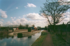
The towpath between Alperton and Paddington is on concrete or tarmac for the whole distance, and therefore I wore my x-trainers rather than my hiking boots, which were neatly stowed away in my rucksack. The going was easy, there were no locks (not that climbing locks requires any special exertions) and the scenery was not particularly urban (it was certainly better than walking into London via smog-filled and dangerous main roads, or by the Thames Path which becomes very dinghy between Teddington Lock and Westminster).
It was very nice walking along this section of canal again after an absence of four and a half years. Unlike the sections further west it really has not changed that much - Old Oak Common railway depot is still visible over a wall, the gas holders near Kensal Green are still present, and the motorway still encroaches over the canal near Paddington. However there were far more joggers than there used to be, perhaps this was down to the fact that it was a Saturday and I always used to walk this section during the week.
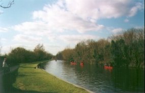
I find it amazing that the canals around London are such an under-used resource. True, fishermen and joggers use them, you get the occasional canal boat and today there were some youngsters canoeing along below the gasholders at Kensal Green. But considering the massive population in London I find it amazing that more people do not use these green corridors through London. They really are an ideal way of cycling or walking from one side of London to the other, and even out of London in various directions.
Directions
From Alperton station walk a few hundred yards to the canal.�Turn right off the steps from the bridge and follow the canal towpath for a little over six miles towards Paddington Basin. Cross over to the other side of the canal and walk along the towpath southwards through Paddington Basin and then along roads to Paddington Station.
Navigation is very easy from Alperton tube station to the canal, and once on the canal it is simply a case of keeping the water on your left. When you get to Paddington Basin a look at the London A to Z could come in handy, although Paddington tube and railway stations are signposted.
Further information
|
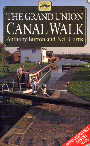
The walk is also covered in detail in the Grand Union Canal Walk, by Anthony Burton and Neil Curtis, ISBN 1 85410 244 3, published by Aurum Press Ltd. Click on the image to the right to go the Amazon page for this book.
For more details on the Grand Union Canal see Jim Shead's canal pages. |
|
Distances
| From | To | Distance (m) | Ascent (ft) | Descent (ft) |
|---|---|---|---|---|
| Alperton station | Old Oak Common | 3.0 | 72 | 85 |
| Old Oak Common | Paddington station | 3.4 | 49 | 62 |
This makes a total distance of 6.4 miles, with 121 feet of ascent and 147 feet of descent.
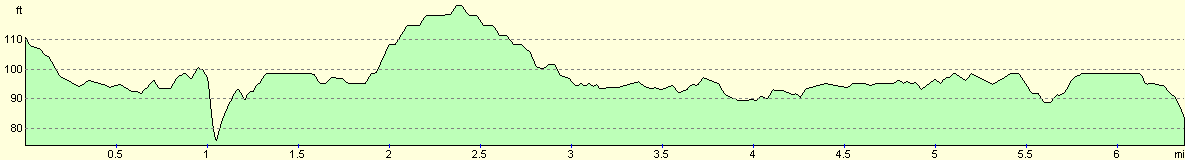
For more information on profiles, ascents and descents, see this page
Transport
Alperton is served by Piccadilly line tube services. Paddington is on the Circle, District and Hammersmith and City lines, and is also served by main-line services.
Disclaimer
Please note that I take no responsibility for anything that may happen when following these directions. If you intend to follow this route, then please use the relevant maps and check the route out before you go out. As always when walking, use common sense and you should be fine.
If you find any information on any of these routes that is inaccurate, or you wish to add anything, then please email me.
All images on this site are © of the author. Any reproduction, retransmissions, or republication of all or part of any document found on this site is expressly prohibited, unless the author has explicitly granted its prior written consent to so reproduce, retransmit, or republish the material. All other rights reserved.
Although this site includes links providing convenient direct access to other Internet sites, I do not endorse, approve, certify or make warranties or representations as to the accuracy of the information on these sites.
And finally, enjoy your walking!
This walk was mentioned in the following routes:
| Grand Union Canal Walk |
| My sectional Land's End to John O'Groats walk |
Nearby walks
| # | Title | Walk length (miles) |
|---|---|---|
| 50 | Paddington to Mile End | 8.3 |
| 51 | Mile End to Enfield Lock | 12.7 |
| 60 | Slough to Alperton | 16.7 |
|
|

|