Walk #64: Long Eaton to Willington
 |
 |
|
General Data
| Date Walked | 19/02/2000 |
| County | Derbyshire, Leicestershire |
| Start Location | Long Eaton |
| End Location | Willington |
| Start time | 09.25 |
| End time | 15.10 |
| Distance | 14.0 miles |
| Description | This was a lovely walk, although at one period I nearly became the founder member of the Sub-aqua chapter of the Long Distance Walkers Association. |
| Pack | Today I carried full Pennine Way kit. |
| Condition | I feel generally okay after this walk, and I could have walked much further if there had been a sensible stopping place. |
| Weather | Initially today was sunny and warm, although it clouded over slightly later and there a sharp five-minute shower in the afternoon when I was having a rest at Stenson. |
| OS map | Landranger number 128 (Derby & Burton upon Trent) and Landranger number 129 (Nottingham & Loughborough, Melton Mowbray) |
 |
 |
|
Map of the walk
Maps courtesy of Google Maps. Route for indicative purposes only, and may have been plotted after the walk. Please let me have comments on what you think of this new format. For a detailed table of timings for this walk, please see the table file.
Notes
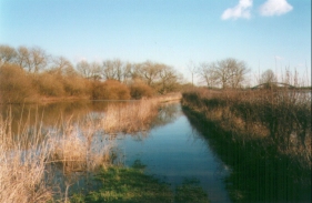
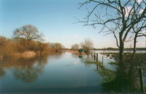
This was an interesting walk on quite a nice day. Since the vast majority of the day was spent walking along canal or rivers it was not the most strenuous walk that I have ever done. The first problem was reached at Derwent Mouth, where the Derwent, Trent and the Trent and Mersey Canal meet. There is a nice bridge going over the river Trent from the Sawley Cut, and when I passed over this bridge I was faced with the beginning of the Trent and Mersey Canal. Unfortunately, after 50 feet the path became totally submerged beneath the flooded Canal and River Derwent.
A lone fisherman was standing in the canal on this small piece of banking, so I stood chatting to him whilst trying to make up my mind on whether to continue.�In the distance I could see Derwent Mouth Lock, so I knew that there was higher ground ahead - it was just a matter of getting to it. We were chatting for five or ten minutes when a cyclist came along from the direction of the lock, his feet peddling furiously below the water. I asked him how deep it was, and since I now knew that it was possible to get through, I tightened up my gaiters and bootlaces and strode off into the flood.
It was knee-deep for most of the way (with a short section of dry banking), but two hundred yards later I reached the lock and higher ground. Amazingly I got very little water in my boots despite the fact that the water level was above the top of my gaiters.
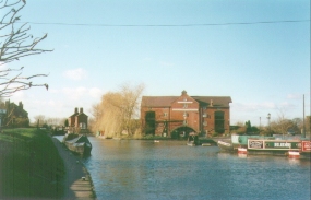
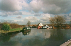
The rest of the walk was along the Canal, and was fortunately dry. It passed Shardlow and a house over (literally!) the river that my dad built and in which my brother and sister were born. Later on it passed through Barrow-On-Trent, where my brother, Auntie and Grandma and Grandpa live (not, I hasten to add, in the same house!), and Stenson, where I was born. So all in all it was a most memorable days walk for me.
Directions
From Long Eaton Station follow the B6540 south-westwards. Cross over two bridges, and once you have crossed the second turn right and follow the Sawley Cut under the M1. Cross the river Trent by a bridge and join the Trent and Mersey Canal a few hundred yards before Derwent Mouth Lock. If it has been raining heavily it may be an idea to check that this part of the route is not flooded - I didn't and it was! From Derwent Mouth Lock head into the village of Shardlow via Great Wilne.
From Shardlow follow the towpath of the Trent and Mersey canal under the A50(T) and past Weston-On-Trent and Swarkestone. Continue past Barrow-On-Trent and the Midlands Canal Centre at Stenson before turning southwards to Willington.
Important note #1
Alan Dorman has kindly informed me that the bridge used early-on in this walk is no longer extant. to quote him: "This route uses Long Horse Bridge to cross the River Trent at Derwent Mouth. That bridge (built in 1932) was demolished in 2003 and its replacement is mired in bureaucracy. The next crossing point on the Trent is Cavendish Bridge at Shardlow but the diversion is quite lengthy."
Important note #2
(12/2011) Alan Dorman has notified me that the replacement bridge is now in place, and is situated about 100 yards upstream of the old bridge. I have yet to visit it, but I assume that the original route is now usable. Details of the saga of the bridge replacement can be found on the Shardlow Heritage website. Photographs of the completed bridge can be seen on the Narrowboat World website.
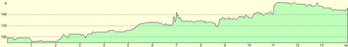
Distances
| From | To | Distance (m) | Ascent (ft) | Descent (ft) |
|---|---|---|---|---|
| Long Eaton station | Shardlow | 3.1 | 26 | 20 |
| Shardlow | Swarkestone | 5.4 | 102 | 79 |
| Swarkestone | Barrow-On-Trent | 1.3 | 39 | 30 |
| Barrow-On-Trent | Willington | 4.2 | 75 | 62 |
This makes a total distance of 14.0 miles, with 242 feet of ascent and 191 feet of descent.
For more information on profiles, ascents and descents, see this page
Transport
There are railway stations at Long Eaton and Willington. To catch a train between the two stations you will have to change at Derby. For more details, see the Railtrack Travel timetable website.
Disclaimer
Please note that I take no responsibility for anything that may happen when following these directions. If you intend to follow this route, then please use the relevant maps and check the route out before you go out. As always when walking, use common sense and you should be fine.
If you find any information on any of these routes that is inaccurate, or you wish to add anything, then please email me.
All images on this site are © of the author. Any reproduction, retransmissions, or republication of all or part of any document found on this site is expressly prohibited, unless the author has explicitly granted its prior written consent to so reproduce, retransmit, or republish the material. All other rights reserved.
Although this site includes links providing convenient direct access to other Internet sites, I do not endorse, approve, certify or make warranties or representations as to the accuracy of the information on these sites.
And finally, enjoy your walking!
This walk was mentioned in the following routes:
| My sectional Land's End to John O'Groats walk |
Nearby walks
| # | Title | Walk length (miles) |
|---|---|---|
| 68 | Willington to Doveridge | 12.6 |
| 95 | Nottingham to Long Eaton | 10.3 |
| 581 | Burton-on-Trent to Derby | 16.3 |
|
|

|