Walk #63: Great Chesterford to Cambridge
 |
 |
|
General Data
| Date Walked | 05/02/2000 |
| County | Essex, Cambridgeshire |
| Start Location | Great Chesterford station |
| End Location | Cambridge Station |
| Start time | 08.05 |
| End time | 13.57 |
| Distance | 16.8 miles |
| Description | This was a very nice and historic walk, including a long section of Roman road. |
| Pack | Today I carried full Pennine Way kit. |
| Condition | I feel generally okay after today's walk. My feet ache a fair bit, and I think that I have bruised my bad ankle slightly. |
| Weather | Today was truly a lovely day. There was a great deal of sunshine, although it was hazy. It was incredibly mild for the time of year, although the wind was quite cold in exposed areas. |
| OS map | Landranger number 154 (Cambridge & Newmarket, Saffron Walden) |
Map of the walk
Maps courtesy of Google Maps. Route for indicative purposes only, and may have been plotted after the walk. Please let me have comments on what you think of this new format. For a detailed table of timings for this walk, please see the table file.
Notes
Since this walk is quite local to me and I have already done the route in reverse, I decided to take a slightly more indirect route for this walk. Great Chesterford is south of Cambridge, but the route I chose heads northeast and then northwest to reach Cambridge. The main reason for this is the lack of footpaths heading in the right direction; the previous walk involved a great deal of road walking. This route also allows me to take in a long (5 to 6 mile) section of a Roman road across a very nice and picturesque part of Cambridgeshire.
This was a lovely walk on a lovely mild winter's day. Anyone who claims that Cambridgeshire has no hills should try this walk; although they are hardly high, they are certainly present!
The going in places was quite muddy; in particular the sections before the Roman road. The Roman road itself was quite easy going, although in places horses had broken up the surface of the bridleway a bit.
Directions
From Great Chesterford Station turn left up the station approach. When you reach the B1383 Newmarket Road turn right and follow it to cross the River Granta via a bridge. Take the first road to the right (Church Street) that you come to and head past the church. Continue along this road through Great Chesterford past the Crown and Thistle and the Plough pubs until you reach the B184 road. For this entire section you can follow signs for the Icknield Way, which this route follows until the Roman road is reached beyond Linton.
Turn right along the B184 and then after a hundred yards turn left up a small track leading uphill alongside a hedge. The track soon becomes a footpath that heads SNE across fields towards Burtonwood Farm. Continue past Burtonwood Farm up to a Trig point near some power cables. From here on follow the Icknield Way down to the A1107 Cambridge to Haverhill road near the village of Linton.
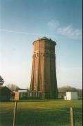
From the A1107 turn right down High Street and follow the road as it swings to the right. Shortly after a newsagents on the left turn left up Coles Lane, and then right along a road past a graveyard. Take a footpath to the left alongside the graveyard as it heads steeply (and muddily) uphill to the water tower at the summit of Rivey Hill. Take the track leading down the hill and join the B1052 road past the entrance to Chilford Hall.
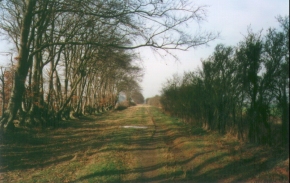
Follow the B1102 and you shortly come across a track heading roughly west-east across the B1052 road. This is an old Roman road. Here we leave the Icknield Way as it turns to the right and our route turns left down the Roman road. The Roman road is now a public bridleway, and it can be followed to the outskirts of Cambridge, crossing minor tracks and the A11(T) road.
Eventually you reach a minor road on the outskirts of Cambridge. Turn left down this road and continue until you reach the A1307. From here onwards road walking is unavoidable, so turn right down the A1307 and head in towards the centre of Cambridge along Hills road. Pass one roundabout that leads to Addenbrooke's hospital and continue along Hills road and over a bridge across the railway. Taking the first major road to the right after the bridge will take you to Cambridge Railway Station.
Distances
| From | To | Distance (m) | Ascent (ft) | Descent (ft) |
|---|---|---|---|---|
| Great Chesterford station | Linton | 5.4 | 322 | 318 |
| Linton | Copley Hill | 6.5 | 453 | 423 |
| Copley Hill | Cambridge station | 4.9 | 148 | 259 |
This makes a total distance of 16.8 miles, with 923 feet of ascent and 1000 feet of descent.
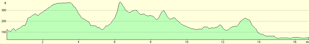
For more information on profiles, ascents and descents, see this page
Transport
There are regular train services between Cambridge and Great Chesterford, run by WAGN. For more details, see the Railtrack Travel timetable website Railtrack website.
Disclaimer
Please note that I take no responsibility for anything that may happen when following these directions. If you intend to follow this route, then please use the relevant maps and check the route out before you go out. As always when walking, use common sense and you should be fine.
If you find any information on any of these routes that is inaccurate, or you wish to add anything, then please email me.
All images on this site are © of the author. Any reproduction, retransmissions, or republication of all or part of any document found on this site is expressly prohibited, unless the author has explicitly granted its prior written consent to so reproduce, retransmit, or republish the material. All other rights reserved.
Although this site includes links providing convenient direct access to other Internet sites, I do not endorse, approve, certify or make warranties or representations as to the accuracy of the information on these sites.
And finally, enjoy your walking!
This walk was mentioned in the following routes:
| My sectional Land's End to John O'Groats walk |
Nearby walks
| # | Title | Walk length (miles) |
|---|---|---|
| 50 | Paddington to Mile End | 8.3 |
| 52 | Enfield Lock to Harlow Town | 12.6 |
| 65 | Alperton to Paddington | 6.4 |
|
|

|