Walk #62: Marlow to Slough
 |
 |
|
General Data
| Date Walked | 23/01/2000 |
| County | Buckinghamshire, Berkshire |
| Start Location | Marlow |
| End Location | Slough |
| Start time | 09.05 |
| End time | 15.10 |
| Distance | 16.3 miles |
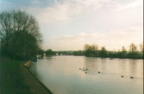
| Description | This was another walk following the Thames Path eastwards. |
| Pack | Today I carried full Pennine Way kit. |
| Condition | I feel reasonably fit after this walk, and slightly better than I did after yesterday's. |
| Weather | Today's weather was very good considering the time of year. It was mostly sunny, although it did occasionally cloud over and once or twice it tried to spit with rain. I walked the entire day without my coat on, which is unusual for January. |
| OS map | Landranger number 175 (Reading & Windsor, Henley-on-Thames & Bracknell) |
Map of the walk
Maps courtesy of Google Maps. Route for indicative purposes only, and may have been plotted after the walk. Please let me have comments on what you think of this new format. For a detailed table of timings for this walk, please see the table file.
Notes
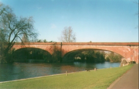
This was yet another good and enjoyable day's walking. The walk was muddy in places, although it was never as bad as yesterday. The nice weather made for a very enjoyable walk, although once past Maidenhead the walk became more boring.
The day was let down slightly by problems getting to Slough after I had left the Thames Path just after Boveney Lock. There is only one suitable footpath that goes under the M4 near Slough, and of course I had to take that. When I got to where the footpath crosses the A335 near the A335 Junction 6 on the M4, the footpath was blocked off by construction work by Nutall. There was a footpath diversion sign, and I followed the diversion for a hundred yards just to meet another diversion sign - pointing back that way that I had just come! I walked back looking carefully at the fence but there was no obvious path over into the construction site or any path on the other side.
Since I was tired and getting ever so slightly disgruntled I climbed up over the fence, jumped over a ditch and climbed up to the A335 dual carriageway. I then had a short walk along the verge to Junction 6 of the M4 and then ran across the motorway slip roads - a dangerous activity at the best of times, yet alone with a 41 pound pack on your back.
I am still very annoyed at this. Such an important footpath (a local told me that it was the only way across the M4 as I had thought from the map) should at the very least have had a map showing the diversion on it - as many other councils do. Since the only alternative was a two-mile diversion with more road walking I was more or less forces to cross the motorway slip roads at the roundabout.
The walk through Slough was not as boring as I had feared, if only because a few youths stopped me to ask what I was doing. I think long-distance walkers carrying packs are somewhat unusual in their estate. They seemed to have very little idea of the larger world outside their immediate area - they did not even know where Marlow was.
Unfortunately in the process of doing this the notes of the day's walks fell out of my pocket, thus explaining why the notes for this day are rather more abbreviated than they normally are.
Directions
Navigation on this walk was very easy. The Thames Path is well signposted, and you only have to pay attention to where you have to cross from one bank of the river to the other. Even in the section where you leave the river for a while around the village of Cookham there are plenty of way posts and markers to let you see the way.
There are a few good guidebooks covering this walk. The one I used is 'The Kennet and Avon Walk', by Ray Quinlan, published by Cicerone Press. I used this book because it also covers the Kennet and Avon Canal which is also on my walk. For the Thames Path section alone you can also use the Thames Path National Trail guide which includes 1:25,000 OS maps of the walk.
Leave the Thames Path shortly east of Boveney Lock, at about SU949779. Turn left and take a footpath that crosses fields slightly to the east of north. This reaches the B3026 in Eton Wick; cross the road and head north for a few yards up The Walk until it ends at Common Road. Note that you may want to make your own way to Slough from here; my route involves crossing a roundabout below the M4. Turn right along Common Road; when this curves to the left, take a footpath that heads off to the half-left.
This footpath heads northeastwards before crossing Common Ditch and heading northwards. At a junction with another footpath turn right and take a footpath that heads northeastwards, aiming for Junction 6 of the M4. Climb up onto the A335 Eton Relief Road and turn left to head towards the roundabout at Junction 6. Carefully cross the sliproads to head northwards to reach Tuns Lane.
Head north along Tuns Lane to another roundabout at SU964797. Here turn right to head eastwards along Church Street; this becomes Shalvey Road as it crosses the B3027. Continue east until the A332 Windsor Road is reached; here turn left to head north to a roundabout. Turn right down the A4 Wellington Road; Slough station is a few yards away on the left.
Distances
| From | To | Distance (m) | Ascent (ft) | Descent (ft) |
|---|---|---|---|---|
| Marlow | Maidenhead Bridge | 8.5 | 108 | 128 |
| Maidenhead Bridge | Eton Wick | 4.9 | 89 | 98 |
| Eton Wick | Slough station | 2.9 | 66 | 33 |
This makes a total distance of 16.3 miles, with 263 feet of ascent and 259 feet of descent.
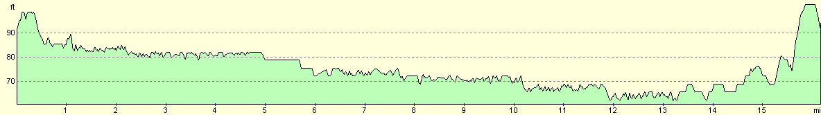
For more information on profiles, ascents and descents, see this page
Transport
There are railway stations at Marlow, Bourne End, Cookham and Maidenhead (on a branch from Maidenhead), and at Maidenhead and Slough on the mainline from London. There are also many local bus services feeding towns along the route.
Disclaimer
Please note that I take no responsibility for anything that may happen when following these directions. If you intend to follow this route, then please use the relevant maps and check the route out before you go out. As always when walking, use common sense and you should be fine.
If you find any information on any of these routes that is inaccurate, or you wish to add anything, then please email me.
All images on this site are © of the author. Any reproduction, retransmissions, or republication of all or part of any document found on this site is expressly prohibited, unless the author has explicitly granted its prior written consent to so reproduce, retransmit, or republish the material. All other rights reserved.
Although this site includes links providing convenient direct access to other Internet sites, I do not endorse, approve, certify or make warranties or representations as to the accuracy of the information on these sites.
And finally, enjoy your walking!
This walk was mentioned in the following routes:
| My sectional Land's End to John O'Groats walk |
Nearby walks
| # | Title | Walk length (miles) |
|---|---|---|
| 51 | Mile End to Enfield Lock | 12.7 |
| 60 | Slough to Alperton | 16.7 |
| 65 | Alperton to Paddington | 6.4 |
|
|

|