Walk #67: Cambridge to Waterbeach
 |
 |
|
General Data
| Date Walked | 05/03/2000 |
| County | Cambridgeshire |
| Start Location | Cambridge Station |
| End Location | Waterbeach |
| Start time | 09.29 |
| End time | 12.14 |
| Distance | 7.6 miles |
| Description | This was a short and pleasant walk through Cambridge, followed by a riverside walk along the Fen Rivers Way northwards to the village of Waterbeach and my home. |
| Pack | Today I carried a *very* small pack. |
| Condition | I feel okay after this walk, and have had no problems. |
| Weather | Today was mostly sunny, with no sign of any rain-bearing cloud, mainly the hazy stuff. There was quite a chilly wind initially that dropped after a short while. |
| OS map | Landranger number 154 (Cambridge & Newmarket, Saffron Walden) |
Map of the walk
Maps courtesy of Google Maps. Route for indicative purposes only, and may have been plotted after the walk. Please let me have comments on what you think of this new format. For a detailed table of timings for this walk, please see the table file.
 |
Notes
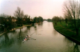
This was a very pleasant morning's walk along the river. The river was very well used, with walkers, joggers, rowers and the obligatory fishermen all enjoying a lovely sunny day.
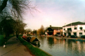
The initial part of the journey through Cambridge until you join the river at Midsummer Common is all road walking, and after that it is firm towpath walking all the way to Clayhithe Bridge. On the other side of the bridge the going can be slightly more muddy, but nothing to harass anyone who has done the Pennine Way ;-)
If anything this walk was a little too easy, as I am now used to doing slightly more testing and longer walks. It was not as bad as it could have been, however, as I had completed a 16.5 mile walk the previous day and therefore I was not as fresh as I would otherwise have been.
Directions
Head straight out of Cambridge Station and head into the City Centre. From there head north to Midsummer Common and join the river. Follow the river along the path on it's south side until you reach the Green Man bridge, Cross over this bridge and turn right and follow the road. At the Pike and Eel pub rejoin the river and the towpath.
The towpath continues northwards under the A14 and past Bait's Bite Lock. There is a bridge at this lock that allows you to gain access to the eastern bank of the river, and there are footpaths that lead from here eastwards to Horningsea and southwards to Fen Ditton. All these paths form part of the Fen Rivers Way, which is a footpath that leads on both sides of the river from Cambridge to Ely.
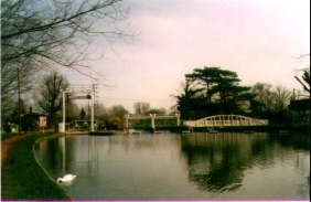
Two miles after Bait's Bite Lock you reach Clayhithe bridge. Here you can either turn left just before the bridge and follow a footpath alongside the road to the station and the village, or turn right over the bridge and then immediately over the bridge to follow the other side of the river northwards.
I crossed over the river and followed the raised banking for a mile to Bottisham Lock, where the river can br re-crossed via a bridge over the lock. A path then leads down to a road which can be followed into the northern side of the village.
Distances
| From | To | Distance (m) | Ascent (ft) | Descent (ft) |
|---|---|---|---|---|
| Cambridge station | Round Church, Cambridge | 1.3 | 0 | 33 |
| Round Church, Cambridge | Waterbeach station | 6.3 | 33 | 43 |
This makes a total distance of 7.6 miles, with 33 feet of ascent and 76 feet of descent.
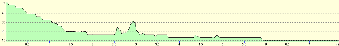
For more information on profiles, ascents and descents, see this page
Transport
There are regular (usually hourly) trains between Waterbeach and Cambridge, the journey taking about six minutes. There are also less-frequent bus services. For details of the train servics, please see the National Rail website.
Disclaimer
Please note that I take no responsibility for anything that may happen when following these directions. If you intend to follow this route, then please use the relevant maps and check the route out before you go out. As always when walking, use common sense and you should be fine.
If you find any information on any of these routes that is inaccurate, or you wish to add anything, then please email me.
All images on this site are © of the author. Any reproduction, retransmissions, or republication of all or part of any document found on this site is expressly prohibited, unless the author has explicitly granted its prior written consent to so reproduce, retransmit, or republish the material. All other rights reserved.
Although this site includes links providing convenient direct access to other Internet sites, I do not endorse, approve, certify or make warranties or representations as to the accuracy of the information on these sites.
And finally, enjoy your walking!
This walk was mentioned in the following routes:
| My sectional Land's End to John O'Groats walk |
Nearby walks
| # | Title | Walk length (miles) |
|---|---|---|
| 56 | Peterborough to Stamford | 16.5 |
| 71 | March to Peterborough | 20.3 |
| 175 | Spalding to Peterborough | 19.5 |
|
|

|