Walk #71: March to Peterborough
 |
 |
|
General Data
| Date Walked | 25/03/2000 |
| County | Cambridgeshire |
| Start Location | March station |
| End Location | Peterborough station |
| Start time | 07.20 |
| End time | 14.40 |
| Distance | 20.3 miles |
| Description | A flat walk along the Fens, following the various rivers and drainage channels in the area. |
| Pack | Full Pennine Way kit. |
| Condition | I set off with only a thin pair of socks on as an experiment, but added a thick pair of woollen socks during lunch at Whittlesey due to hotspots developing. Hence I may have a blister or two after today. |
| Weather | Today started off very fine and sunny, without a cloud in he sky. Unfortunately, as time passed the sky slowly became cloaked with cloud, until there a five-minute shower just past the Dog-in-a-doublet bridge. I dried out just in time for heavier rain to start on the outskirts of Peterborough, although my kit stood up well and I did not get wet. |
| OS map | Explorer number 227 (Peterborough) or Landranger number 142 (Peterborough, Market Deeping & Chatteris) |
Map of the walk
Maps courtesy of Google Maps. Route for indicative purposes only, and may have been plotted after the walk. Please let me have comments on what you think of this new format. For a detailed table of timings for this walk, please see the table file.
Please note that the distances quoted are rough estimations as measured off a 1:25,000 OS map, but does equate quite well with the distances shown on signs.
Notes
This is the longest walk that I will have to do for a long period (I generally tend to try to plan my walks to be 17 miles or under). As such I used it as an experiment to see how well I will stand up to the rigours of the walks coming up in the four-days continuous walking that I am planning to do the week after next.
Since I am not very fatigued this evening (although my feet have suffered as mentioned above), I am ready for the four day's walking that I have to do eastwards from Bath.
Now that the days are getting longer, it is nice that I can spend a little extra time on the walks and not have to hurry to the finish. For instance today it was nice being able to stop for a while in Whittlesey and have a few cokes in a local pub.
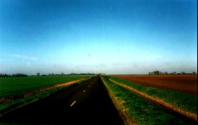
The best way to describe the day's walking is flat. So very, very flat. It is also quite straight, with several multi-mile straight sections that you can just power along.
Directions
Turn right out of March station and head south down the B1101. When you reach the river, turn right down West End, a very attractive part of March beside the river. Do not cross the bridge, but instead follow the northern bank westwards.
After a while you reach the A141. Cross over the road and follow the path on the other side as it skirts a marina. Shortly the path reaches the river again and you follow the raised banking for a while.
Shortly afterwards the path is blocked off. Turn right at the blockage and head up a track to a road. Turn left along the road until you pass the factory that causes the blockage.
From here, you have a choice of route; you can turn left down to the river to follow the Hereward Way or continue along the road. I chose to do the latter. There is not much difference between the two routes in terms of distance. The road has a series of straight sections punctuated by sharp turns, and later on several railway crossings. After a few miles you reach the village of Turves, and you rejoin the Hereward Way.
Follow the road north directly out of Turves, and then sharp left as it turns south-westwards following the Bevill's Leam Drain. When the road turns right over the river at Beggars' Bridge, continue straight on under the railway line and on the banking south-westwards. Shortly after passing Poplartree Bridge over the Drain, turn half-left to join the B1093 at Angle Corner Bridge.
Turn right and follow the B1093 over the Drain. When the B1093 turns right, continue straight on beside the Brigatte River for a mile and a half. When it reaches another road, follow it northwestwards past Whittlesey Station and into the centre of the town.
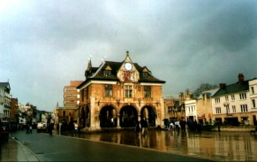
Continue north past the market square in Whittlesey and find your way to theroundabout between the B1040 and A605 roads. Head north along the B1040 out of the town. Shortly after crossing Moreton's Leam Drain take a bridleway heading north-east. This soon turns northwards to parallel the road - it provides a safe route off the road. When the River Nene is reached turn left and rejoin the road at the bridge. Cross the road and the bridge and take the road down to the left which leads past the Dog-in-a-Doublet pub and Lock.
From here you can follow the bank on the right to keep off the road as you follow the road and river in a straight line. When eventually the road turns to the right, continue straight on down a track. Peterborough can be seen growing in front of you as you pass near a power station and beside a sewage works. After crossing a little channel that drains into the Nene, continue on beside the river and under the large A1139 bridge. When you reach another road bridge turn right into the centre of Peterborough. From here signs for the railway station are frequent.
Transport
There are regular train services from Peterborough railway station to March. Be careful, however, as some trains do not stop at March and continue onto Ely without stopping.
Distances
| From | To | Distance (m) | Ascent (ft) | Descent (ft) |
|---|---|---|---|---|
| March station | Turves | 6.7 | 16 | 30 |
| Turves | Whittlesey | 5.8 | 30 | 16 |
| Whittlesey | Peterborough station | 7.8 | 33 | 16 |
This makes a total distance of 20.3 miles, with 79 feet of ascent and 62 feet of descent.
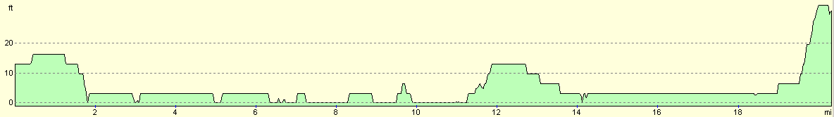
For more information on profiles, ascents and descents, see this page
Disclaimer
Please note that I take no responsibility for anything that may happen when following these directions. If you intend to follow this route, then please use the relevant maps and check the route out before you go out. As always when walking, use common sense and you should be fine.
If you find any information on any of these routes that is inaccurate, or you wish to add anything, then please email me.
All images on this site are © of the author. Any reproduction, retransmissions, or republication of all or part of any document found on this site is expressly prohibited, unless the author has explicitly granted its prior written consent to so reproduce, retransmit, or republish the material. All other rights reserved.
Although this site includes links providing convenient direct access to other Internet sites, I do not endorse, approve, certify or make warranties or representations as to the accuracy of the information on these sites.
And finally, enjoy your walking!
This walk was mentioned in the following routes:
| My sectional Land's End to John O'Groats walk |
Nearby walks
| # | Title | Walk length (miles) |
|---|---|---|
| 2 | Waterbeach to Newmarket Road, Cambridge | 5.4 |
| 5 | A short walk around Waterbeach to Car Dyke | 3.0 |
| 6 | Waterbeach to Newmarket Road, Cambridge | 5.4 |
|
|

|