Walk #54: Ely to March
 |
 |
|
General Data
| Date Walked | 30/10/1999 |
| County | Cambridgeshire, Norfolk |
| Start Location | Ely Station |
| End Location | March Station |
| Start time | 07.55 |
| End time | 14.55 |
| Distance | 22.9 miles |
| Description | This was a walk mostly following the Hereward Way between Ely and March. |
| Pack | Today I carried full Pennine Way kit. |
| Condition | I feel very fatigued after this walk. I have developed a couple of blisters, and I am very tired. Fortunately my shoulders and back are okay, despite the trouble I had on the Pennine Way. |
| Weather | The weather today started off cloudy, after which it became sunny and windy, and then finally the clouds gathered and it became overcast. There was one short shower just before the end of the day, and it was quite a warm day when I was sheltered from the wind. |
| OS map | Landranger number 143 (Ely & Wisbech, Downham Market) |
Map of the walk
Maps courtesy of Google Maps. Route for indicative purposes only, and may have been plotted after the walk. Please let me have comments on what you think of this new format. For a detailed table of timings for this walk, please see the table file.
Notes
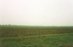
This is the longest walk of the entire section of my Land's End to John O'Groats walk from London so far, and quite a tiring one. The entire section is very flat, with no hills of any size at all. Indeed for large sections of the walk you are at sea level. There are moderate amounts of road walking to be done, although well over half of the route is on footpaths.
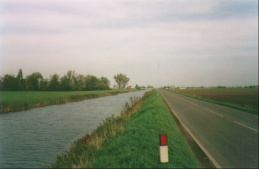
This are of the Fens can actually be quite remote - from Little Downham just north of Ely the next shops of any description were 11 miles later at Welney. It is also a walk that can frequently only be done in summer or autumn, as the route crosses the Hundred Foot Washes at Welney via the B1411. This road is very often closed as it becomes flooded by up to six feet of water. Hence it is advisable to check the status of the washes before setting out on this walk.
Directions
Very basically follow the Hereward Way northwards out of Ely through Little Downham, Welney and Christchurch before arriving at March. The route is fairly well way-marked, the only problem I had was working the correct route out of Little Downham (head for the top-left corner of the playing field, exit to the field adjacent and head north between two fields).
There is a leaflet describing the Ely to Peterborough section of the Hereward Way available from Cambridgeshire Tourist Information. The Hereward Way along this section is fairly well way-marked, but it is also worth getting the OS map that covers the route as well (OS Landranger 143).
Distances
| From | To | Distance (m) | Ascent (ft) | Descent (ft) |
|---|---|---|---|---|
| Ely station | Welney | 11.4 | 184 | 190 |
| Welney | March | 11.5 | 49 | 36 |
This makes a total distance of 22.9 miles, with 233 feet of ascent and 226 feet of descent.
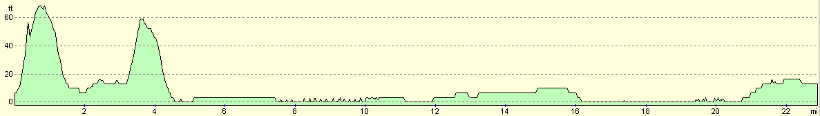
For more information on profiles, ascents and descents, see this page
Disclaimer
Please note that I take no responsibility for anything that may happen when following these directions. If you intend to follow this route, then please use the relevant maps and check the route out before you go out. As always when walking, use common sense and you should be fine.
If you find any information on any of these routes that is inaccurate, or you wish to add anything, then please email me.
All images on this site are © of the author. Any reproduction, retransmissions, or republication of all or part of any document found on this site is expressly prohibited, unless the author has explicitly granted its prior written consent to so reproduce, retransmit, or republish the material. All other rights reserved.
Although this site includes links providing convenient direct access to other Internet sites, I do not endorse, approve, certify or make warranties or representations as to the accuracy of the information on these sites.
And finally, enjoy your walking!
This walk was mentioned in the following routes:
| My sectional Land's End to John O'Groats walk |
Nearby walks
| # | Title | Walk length (miles) |
|---|---|---|
| 43 | Garigill to Slaggyford | 9.2 |
| 45 | Once Brewed to Bellingham | 15.4 |
| 929 | Hadrian's Wall Path: Carlisle to Greenhead | 22.2 |
|
|

|