Walk #72: Bath to Devizes
 |
 |
|
General Data
| Date Walked | 01/04/2000 |
| County | Avon, Wiltshire |
| Start Location | Bath YHA |
| End Location | Devizes |
| Start time | 08.50 |
| End time | 17.00 |
| Distance | 19.3 miles |
| Description | A nice but annoying canal walk, with canal stoppages meaning frequent diversions along roads away from the canal. |
| Pack | Full Pennine Way kit. |
| Condition | Knackered. My energy levels were fine all day, and I have no new blisters. I have a small amount of back ache and my feet feel sore. |
| Weather | It was attempting to spit on-and-off all day. There was little or no sunshine, but it never actually poured. The temperature was about right. I seemed to spend large portions of the day putting up and taking down my coat hood. |
| OS map | Landranger number 172 (Bristol & Bath, Thornbury & Chew Magna) and Landranger number 173 (Swindon & Devizes, Marlborough & Trowbridge) |
 |
Map of the walk
Maps courtesy of Google Maps. Route for indicative purposes only, and may have been plotted after the walk. Please let me have comments on what you think of this new format. For a detailed table of timings for this walk, please see the table file.
For more details of the distances involved with this walk, please see Jim Shead's waterways pages.
Notes
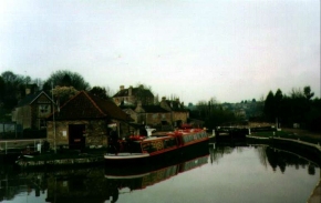
A nice but hard day during which I got further than I had been planning - a rough estimate is 21 to 22 miles. I got to Semington before 13.00 been planning to spend the night) and I went into the Somerset Arms, a very friendly pub. Since it was so early I decided to press onto Devizes and find accommodation there. Unfortunately several sections of canal (including the flight of locks up Caen Hill into Devizes) were subject to stoppages and were drained, and therefore I was forced to road-walk from before Seend into Devizes. This was an especial shame as it meant that I did not get to see the Caen Hill lock flight, which was going to be a highlight of my trip.
Walking the extra 6.5 miles into Devizes (which was probably more due to the diversions due to the canal stoppages) from Semington has tired me out, but it has set me up well for the rest of the walk. Unfortunately it looks as though the weather is going to be awful tomorrow, so I may have a short day to compensate for the weather. The B&B I am staying at (Rockley, on London Road in Devizes) is very, very nice and yet cheap at £18.00 for a night.
Devizes is also the home of the brewers who brew 6X beer, so I just had to walk into town in the evening after my bath to find a local hostelry where I could have an evening meal and imbibe a few pints of the liquid. And I liked it so much, I imbibed a couple more.
Directions
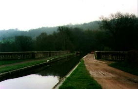
From Bath YHA head eastwards up the hill towards the University. At the top of the hill take the road that heads around Claverton Down and then take the road that heads steeply down to the River Avon. About halfway down a footpath leads off to the left (eastwards) down a steep slope. Down this hill you get a good view of the Dundas Aqueduct. Be careful where the path meets the A36(T); there is a step down from a stile leading directly onto the road that is stone and was very slippery when wet - I climbed over the stile and slipped on the stone, depositing me on the verge of the road with traffic roaring past. Not a pleasant feeling.
Cross over the A46(T) and take a footpath leading down from the lay-by to Dundas Aqueduct. From Dundas Aqueduct it should just be a case of following the Kennet and Avon Canal eastwards through Bradford-on-Avon and Semington to Devizes. Unfortunately, due to stoppages I had to take the following diversion between Seend Cleve and Devizes.
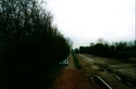
From the canal at Seend I had to take a road up the hill for a short distance before taking a footpath to the left that headed up into the village of Seend. I then followed the A361 eastwards through the village and down the hill to its junction with the A365. Continue east along the A361 until it becomes a dual carriageway. Please note that the entire route between the A365 junction and the dual carriageway was quite dangerous as it was a very busy road and I felt quite vulnerable. If at all possible take the canal route for this section; not just is it more direct, it is also far safer.
The A361 becomes dual carriageway just before Caen Hill which leads up into Devizes. Cross over onto the northern side of the road where a pavement starts. This section is far safer than the preceding one due to the pavement. I managed to regain the towpath at the top of the flight of locks, and could follow the canal eastwards through the town. My B&B was on the eastern side of town, near the bridge that carries the A361 over the canal.
Distances
| From | To | Distance (m) | Ascent (ft) | Descent (ft) |
|---|---|---|---|---|
| Bath YHA | Dundas Aqueduct | 1.9 | 200 | 528 |
| Dundas Aqueduct | Semington Bridge | 9.7 | 456 | 443 |
| Semington Bridge | Devizes | 7.7 | 541 | 246 |
This makes a total distance of 19.3 miles, with 1197 feet of ascent and 1217 feet of descent.
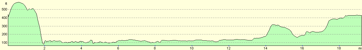
For more information on profiles, ascents and descents, see this page
Disclaimer
Please note that I take no responsibility for anything that may happen when following these directions. If you intend to follow this route, then please use the relevant maps and check the route out before you go out. As always when walking, use common sense and you should be fine.
If you find any information on any of these routes that is inaccurate, or you wish to add anything, then please email me.
All images on this site are © of the author. Any reproduction, retransmissions, or republication of all or part of any document found on this site is expressly prohibited, unless the author has explicitly granted its prior written consent to so reproduce, retransmit, or republish the material. All other rights reserved.
Although this site includes links providing convenient direct access to other Internet sites, I do not endorse, approve, certify or make warranties or representations as to the accuracy of the information on these sites.
And finally, enjoy your walking!
This walk was mentioned in the following routes:
| My sectional Land's End to John O'Groats walk |
Nearby walks
| # | Title | Walk length (miles) |
|---|---|---|
| 56 | Peterborough to Stamford | 16.5 |
| 59 | Oakham to Melton Mowbray | 10.6 |
| 205 | Oakham to Leicester | 19.5 |
|
|

|