Walk #59: Oakham to Melton Mowbray
 |
 |
|
General Data
| Date Walked | 18/12/1999 |
| County | Rutland, Leicestershire |
| Start Location | Oakham |
| End Location | Melton Mowbray |
| Start time | 09.34 |
| End time | 13.30 |
| Distance | 10.6 miles |
| Description | This was a short walk north-westwards from Oakham to Melton Mowbray following roads and footpaths. |
| Pack | Today I carried my full Pennine Way kit. |
| Condition | I feel quite fine after this walk, although my feet still ache slightly. |
| Weather | Today was quite a cold day. There had been a heavy frost overnight and in sheltered places there was no thaw. There was some high-level cloud in the sky, giving alternate cloudy and sunny periods, but thankfully not a drop of rain. |
| OS map | Explorer number 15 (Rutland Water) and Landranger number 129 (Nottingham & Loughborough, Melton Mowbray) |
Map of the walk
Maps courtesy of Google Maps. Route for indicative purposes only, and may have been plotted after the walk. Please let me have comments on what you think of this new format. For a detailed table of timings for this walk, please see the table file.
Notes
A fairly nice walk on a bitterly cold day. It promised to be as muddy as the Stamford to Oakham section had been the week before, but the hard frost kept most of the fields firm.
For the first time in a long while a planned route had to be diverted from due to my not being able to find the footpath heading westwards out of Whissendine. It says something when you cannot even follow a route that is clearly marked out on a 1:25,000 scale map! Fortunately the quiet Melton road could be used instead of that footpath, so I did not spend too long searching for the path.
Directions
From Oakham station take a footpath that leads from near the level crossing with the A606 and heads to the northwest behind a school and over playing fields to meet up with the A606 again. Follow the A606 for two miles into the little village of Langham. There is a footpath beside the road for the full distance, and on the Saturday when I did this section the road was not too busy.
Langham is worth a few minutes inspection, and this can be done by heading northwards through the village when the A606 takes a sharp left turn. When you reach a T-junction in the village turn left along a road and then almost immediately right along a footpath that takes you across another road and across fields to meet the A606 once again. The footpath should have brought you out at a junction between the A606 and a minor road heading NNW towards Whissendine. Head along this road.
When you reach the top of the hill, take a footpath that heads across fields to the north (not the track to the east) and which follows a stream. A little over a mile later you reach the village of Whissendine. Follow roads through the village until you reach a T-junction. It had been my intent to turn north here and then westwards to follow a footpath that shadows the Melton road westwards. However, despite initial clear signs, the path soon disappeared, with very overgrown (and barbed-wired) stiles and eventually an area of new housing.
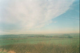
I gave up on the footpath after that and committed myself to following the Melton Road. This was a quiet road and there was little traffic as I passed Browne's Lodge and down the hill to pass into Leicestershire. Just after a road junction to the left you reach one to the right. Follow this road up the hill until you reach the driveway for Jericho Lodge (this is where the footpath from Whissendine would have emerged). From this hill you get a nice view to the northwest towards Burton Lazars, although Melton Mowbray is hidden from view in a valley.
Follow the footpath that descend down the hill westwards from Jericho Lodge and take footpaths. Near the bottom of the hill turn right along another footpath that heads northwest past Berry Covert, which then turns northwards to head to the east of Sapcoat's Spinnet. Shortly north of here, turn left to join another footpath that heads westwards.
Shortly after it crosses a brook the footpath splits; take the right-hand fork that climbs uphill into the village of Burton Lazars. Turn left along a road for a few yards and then turn right to head north through Burton Lazars; cross another road, and continue on along the footpath for a few hundred yards until you reach a track heading west to east. Follow this track to the west until it emerges on the A606 once again on the southern outskirts of Melton Mowbray. It is then a simple case of following a footpath beside this road for 3/4 of a mile down into the centre of Melton Mowbray and the station.
Distances
| From | To | Distance (m) | Ascent (ft) | Descent (ft) |
|---|---|---|---|---|
| Oakham station | Whissendine | 4.2 | 184 | 157 |
| Whissendine | Melton Mowbray station | 6.6 | 322 | 476 |
This makes a total distance of 10.6 miles, with 506 feet of ascent and 633 feet of descent.
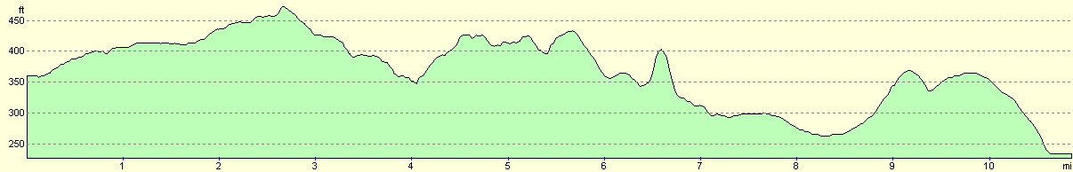
For more information on profiles, ascents and descents, see this page
Transport
There are regular trains running between Melton Mowbray and Oakham.
Disclaimer
Please note that I take no responsibility for anything that may happen when following these directions. If you intend to follow this route, then please use the relevant maps and check the route out before you go out. As always when walking, use common sense and you should be fine.
If you find any information on any of these routes that is inaccurate, or you wish to add anything, then please email me.
All images on this site are © of the author. Any reproduction, retransmissions, or republication of all or part of any document found on this site is expressly prohibited, unless the author has explicitly granted its prior written consent to so reproduce, retransmit, or republish the material. All other rights reserved.
Although this site includes links providing convenient direct access to other Internet sites, I do not endorse, approve, certify or make warranties or representations as to the accuracy of the information on these sites.
And finally, enjoy your walking!
This walk was mentioned in the following routes:
| My sectional Land's End to John O'Groats walk |
Nearby walks
| # | Title | Walk length (miles) |
|---|---|---|
| 58 | Stamford to Oakham | 16.8 |
| 66 | Melton Mowbray to Bingham | 16.1 |
| 205 | Oakham to Leicester | 19.5 |
|
|

|