Walk #66: Melton Mowbray to Bingham
 |
 |
|
General Data
| Date Walked | 04/03/2000 |
| County | Leicestershire, Nottinghamshire |
| Start Location | Melton Mowbray |
| End Location | Bingham |
| Start time | 08.40 |
| End time | 14.10 |
| Distance | 16.1 miles |
| Description | Today involved a great deal of road walking as I crossed the Vale of Belvoir northwards from Melton Mowbray. |
| Pack | Today I carried a very small pack. |
| Condition | I feel absolutely fine after this walk, and have had no problems. |
| Weather | 3/4 sun, 1/4 cloud. It stayed fine all day, although there was a bitter wind and puddles still had a covering of ice even at 13.00. It was a glorious day, nonetheless. |
| OS map | Landranger number 129 (Nottingham & Loughborough, Melton Mowbray) |
Map of the walk
Maps courtesy of Google Maps. Route for indicative purposes only, and may have been plotted after the walk. Please let me have comments on what you think of this new format. For a detailed table of timings for this walk, please see the table file.
Notes
This was a highly interesting walk between the towns of Melton Mowbray and Bingham that had everything, the local Belvoir Hunt in full flow, glorious sunshine and even a car crash to add to the excitement.
Due to an injury I had suffered during the previous week I chose to take this walk as a test, and hence carried a pack with only my Walking boots in and wore my trainers for the whole way. Unfortunately the descent from Hazel Tongue Farm along the only stretch of footpath on today's walk was very muddy, and particularly a stretch at the farm where the path was obscured by slurry, which got my trainers in a very nasty condition.
I am not someone who particularly enjoys road walking, but nevertheless I found this walk very enjoyable, particularly for the views down the Vale of Belvoir from the higher ground to the south. Near the end of the walk I passed followers of the Vale of Belvoir hunt, who, after they worked out that I was not a hunt saboteur, offered me a glass of wine that I politely refused. In the distance there were horses running across fields, and as always I thought that horses in full flight are a truly magnificent sight.
Directions
From the railway station in Melton Mowbray head into the city centre and take the road heading directly north towards Scalford. Shortly before Scalford Hall is reached take a left and then a right to head up a road to the north-north-west.
At the top of Brown's Hill (the highest point of the walk at 152 metres) take Stone Penn Lane that leads off to the right and follow it downhill to a road junction. Continue straight on at the junction and when you reach Hazel Tongue Farm turn left to take a very muddy bridleway that heads straight down the hill to the north, before ending at a road by the windmill at Mill Farm. Join the road and head into the village of Long Clawson. This footpath gives some wonderful views over the Vale of Belvoir below, and it is possible to make out Bingham and even Nottingham itself to the north.
Head east out of Long Clawson along Hose Lane, and then along more roads to the village of Hose itself. In Hose follow the road as it turns and skirts the south side of the village to head northeastwards towards the village of Harby.
Go through Harby and follow the road northwards that is signposted to Langar and Bingham. Just outside the village of Harby the road crosses the Grantham Canal. Even though the canal is now disused and even drained in sections, the towpath is extant throughout it's length and so it could well make an interesting (although winding) route between Grantham and Nottingham.
The road crosses the Leicestershire / Nottinghamshire border, and then halfway between Harby and Langar you pass an airfield on the right which offers skydiving instruction and courses.
When Langar is reached follow the road through the village and down the hill towards Bingham. This four-mile section is fairly plain, and fortunately the road is not too busy.
The approach to Bingham is broken by the A52(T) road, which has to be crossed. It is then simply a journey down the hill into the centre of the village and the market square.
Distances
| From | To | Distance (m) | Ascent (ft) | Descent (ft) |
|---|---|---|---|---|
| Melton Mowbray station | Long Clawson | 6.1 | 348 | 354 |
| Long Clawson | Langar | 5.6 | 56 | 177 |
| Langar | Bingham station | 4.4 | 131 | 157 |
This makes a total distance of 16.1 miles, with 535 feet of ascent and 688 feet of descent.
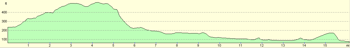
For more information on profiles, ascents and descents, see this page
Transport
It is possible to catch trains from Bingham station into Nottingham, and thence from Nottingham to Leicester where you can change for a Peterborough train to Melton Mowbray.
There are also bus servics every ten minutes (weekdays and Saturdays) from Bingham into the city centre. These take longer than the train, but are more frequent. You can then catch an hourly service to Melton Mowbray from the Broadmarsh bus station in Nottingham.
I set out fully intending to catch the train, but since there was a bus so temptingly waiting for me in the centre of Bingham I caught that instead of waiting 45 minutes for the train. I then had an hour to go shopping in Nottingham before catching the bus to Melton Mowbray.
Disclaimer
Please note that I take no responsibility for anything that may happen when following these directions. If you intend to follow this route, then please use the relevant maps and check the route out before you go out. As always when walking, use common sense and you should be fine.
If you find any information on any of these routes that is inaccurate, or you wish to add anything, then please email me.
All images on this site are © of the author. Any reproduction, retransmissions, or republication of all or part of any document found on this site is expressly prohibited, unless the author has explicitly granted its prior written consent to so reproduce, retransmit, or republish the material. All other rights reserved.
Although this site includes links providing convenient direct access to other Internet sites, I do not endorse, approve, certify or make warranties or representations as to the accuracy of the information on these sites.
And finally, enjoy your walking!
This walk was mentioned in the following routes:
| My sectional Land's End to John O'Groats walk |
Nearby walks
| # | Title | Walk length (miles) |
|---|---|---|
| 59 | Oakham to Melton Mowbray | 10.6 |
| 76 | Bingham to Nottingham | 13.5 |
| 593 | Sleaford to Bottesford | 23.3 |
|
|

|