Walk #937: SWCP: Sidmouth to Exmouth
 |
 |
|
General Data
| Date Walked | 07/11/2011 |
| County | Devon |
| Start Location | Sidmouth |
| End Location | Exmouth Fernside Hotel |
| Start time | 09.58 |
| End time | 16.39 |
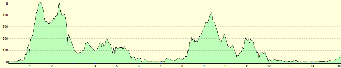
| Distance | 15.5 miles |
| Description | This was a superb day's walk following the South West Cast Path westwards from Sidmouth to Buddleigh Salteron and on to Exmouth. There are a couple of hills to be climbed on the way, but none of the climbs are as strenuous as those seen earlier on the SWCP. |
| Pack | Today I carried my 30-litre Karrimor rucksack, filled with water, my waterproofs, a book and other odds and ends. |
| Condition | We both felt fine after this walk, with no problems to report despite the ascent and descent during the day. |
| Weather | Today started off quite cold; yesterday's sunshine had been replaced with a layer of cloud. The cloud stubbornly remained all day but at least it warmed up a little. I think I detected a few little flakes of snow in the air early on, but Sencan did not see any. The wind was northerly which means that it is more than a little possible. |
| OS map | Landranger number 192 (Exeter & Sidmouth, Exmouth & Teignmouth) |
 |
 |
|
Map of the walk
Maps courtesy of Google Maps. Route for indicative purposes only, and may have been plotted after the walk. Please let me have comments on what you think of this new format. For a detailed table of timings for this walk, please see the table file.
 |
 |
|
Notes
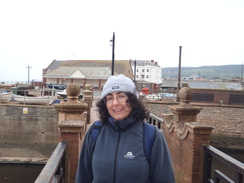
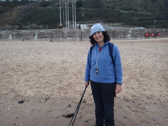
Sencan had managed to get her first week off work since February, and so we decided to take a trip down to the south west to continue our stroll along the SWCP. We had last walked along this the previous December, our progress having been stifled by a move to Cambridgeshire. On that trip we had got as far as Sidmouth, so after spending Saturday night with friend in Purley we travelled along the A303 to Exmouth. Getting a hotel was not problematic out of season, and after we unpacked we went for a very long walk around Exmouth. It was cold but the lights reflecting in the still waters of the Exe Estuary were magnificent.
We had breakfast early so we could get down to the bus stop in the centre of town in plenty of time to catch the 08.42 bus to Sidmouth. I was surprised to see that this bus took an hour to reach the seaside town but the reason soon became obvious - after reaching Budleigh Salterton it literally travelled around the houses, taking a very indirect route. The bus driver did some stellar driving on the narrow roads and dropped us off in the centre of Sidmouth at the scheduled time.
Our first task was to find a place to buy some gloves because we had rather stupidly left them at home, not having expected such cold weather. We walked through the town until we found an outdoor shop. Luckily their gloves were part of a two-for-the-price-of-one deal and so we furnished ourselves before heading off through the town to the seafront and the bridge over the River Sid, where we had ended the last walk.
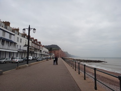
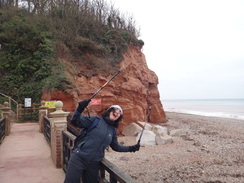
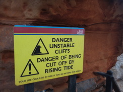
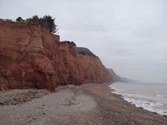
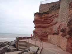
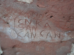
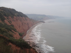
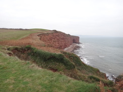
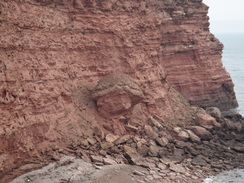
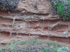
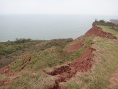
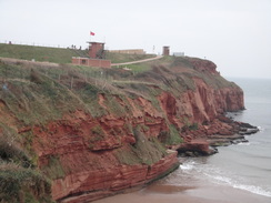
Sidmouth seemed like a pleasant place even on a grey November morning, and it did not seem to have suffered as much as many seaside resorts. Joggers and dog-walkers strolled with us as we headed west, some giving us strange looks. We joined a promenade that squeezed underneath the beautiful red cliffs which had been engraved with graffiti. The rock is sandy and soft, meaning that it is essentially self-cleaning - the graffiti gets eroded away, and there were places where newer graffiti could be seen with faint marks from the old behind.
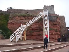
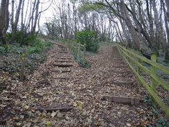
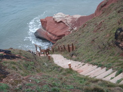
Sencan decided to put her new gloves in her rucksack, only to find a pair of her undies were hanging off the back of her pack, perhaps explaining why people had been giving us such funny looks! There is something indefinable about the red cliffs that I love, and it was a shame when we reached Jacob's Ladder. This is a set of wooden steps that ascends vertically onto the cliffs above. We took the ladder rather than the adjacent slope which carries the trail because it looked far more interesting, and soon we were high on the cliff. Sencan though I was rather obsessive for counting the number of steps on the ladder - 53 in total, but I told her that such information could be (ahem) vital.
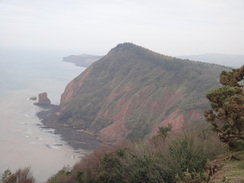
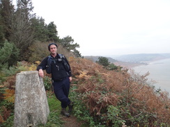
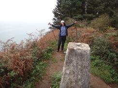
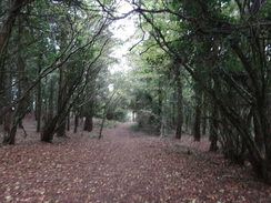
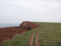
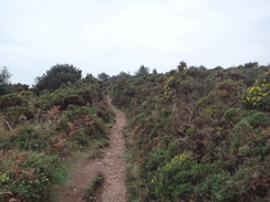
A grassy path continued ascending alongside a road, and soon after this an old road took us uphill. The reason why the road had been diverted soon became obvious as a large chunk of tarmac had disappeared down the cliffs. Eventually the road was left behind and a path continued climbing with the cliff-edge never far away to the left until it entered the woodland around High Peak. There is a trig pillar at the summit of this cliff but the trail takes a slightly lower, inland rote; we ignored the first turn to the trig pillar but soon came across another path that headed directly uphill, and on the spur of the moment decided to climb it. The views from the top were good, although not expansive due to the surrounding trees and the hazy skies. Due to the steep and slippery nature of the ascent we decided to take the other route down, although even this was difficult in places.
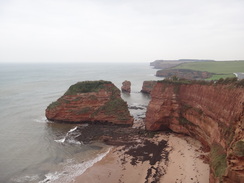
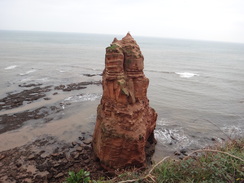
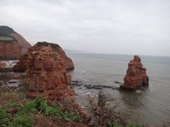
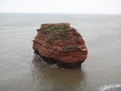
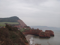
An easy descent took us out of the woodland and down towards Ladram Bay. A large caravan park scarred the hillsides ahead, but our gaze was directed towards the wonderful red sandstone stacks that emerged from the sea to our left. These looked magnificent and I had to frequently stop in order to take some photos. It really is a lovely stretch of coast and it was a shame that the weather meant that the views were spoilt.
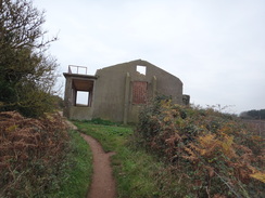
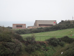
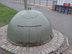
This was Sencan's first walk with me for some time and she seemed to be feeling fine after our first climb. We passed the holiday park at Ladram Bay (which had a rather good-looking childrens' play area) and continued south along the cliffs. It was easy going and soon we reached an old observation post on Brandy Head, from where bombing runs with experimental weapons were viewed during the Second Wold War.
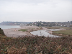
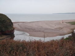
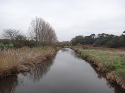
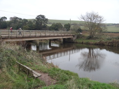
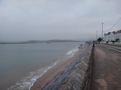
Soon we reached Danger Point, where the trail left the coast and started following the River Otter upstream. There were a few minor climbs, but soon the bridge across the river came into view. The walk down the western bank of the river proved to be much easier along a level embankment that had been constructed by Napoleonic prisoners of war. We were thankful for their efforts as the easy path took us to the mouth of the river once more on the outskirts of Budleigh Salterton.
We headed west along the promenade, but pangs of hunger soon caused us to divert inland to find somewhere to eat. In the end we settled for a cafe that turned out to be rather nice - Sencan actually had two snacks whilst I settled for Welsh Rarebit and a couple of the best milkshakes that I have had for some time. The staff were friendly as well, despite mud from the cleats of my new boots falling all over the floor.
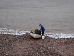
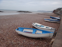
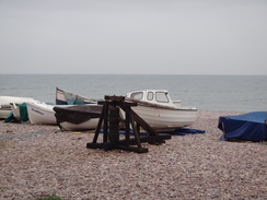
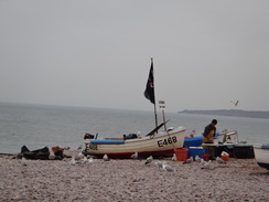
Soon we got back to the trail and started following it uphill towards the summit of West Down Beacon. A man was standing on the beach gutting fish on a table beside a small rowing boat; he was throwing the viscera to a flock of seagulls who were waiting on the shingle. In many ways it seemed a timeless scene and I could imagine his ancestors doing similar work many hundreds of years before. No machinery was in sight, and only the modern colours of the boats and his modern sou'westers anchored it in the present.
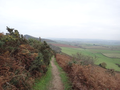
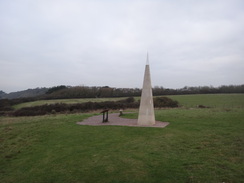
The climb onto West Down Beacon was easy - so easy in fact that it was sometimes hard to realise we were actually climbing. Somehow I missed the trig pillar at the summit and we started the descent down towards yet another caravan park near Straight Point. The latter is a military shooting range, and the occasional put-put' of rifle fire added emphasis to the red flags. It was a relief when the seemingly never-ending caravan park was left behind and easy cliffs took us westwards towards the monument on Orcombe Point.
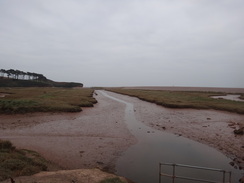
This had been erected in 2002 and marks the eastern end of the Jurassic Coast. Sadly the two information boards had been destroyed, and the plaque on the monument commemorating its unveiling by Prince Charles had been sickeningly graffitied with killed his wife'. Some steps down the cliffs nearby had been closed off and no wonder - the wooden steps at the bottom had been washed away.
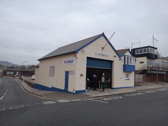
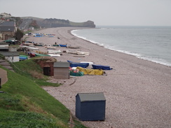
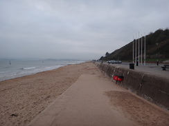
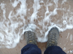
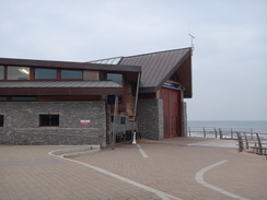
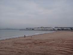
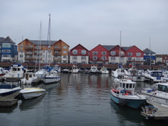
It did not take a long walk to reach the ramps that led down onto the eastern end of the promenade in Exmouth. After crossing the beach to dip our boots in the sea we rejoined the promenade and followed it towards the town centre. Initially it is surprisingly undeveloped, but the buildings soon started as we passed the rather spectacular new lifeboat station and approached the docks. This whole area has been massively redeveloped since I walked here nine years ago and the buildings and apartments looked more suitable for the centre of a city than a sleepy seaside town.
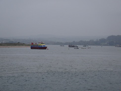
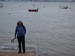
We were now rounding the mouth of the River Exe, and the sandy spit of Dawlish Warren was clearly visible across the estuary. The new buildings were soon left behind and we were walking through more classic fishing-port terrain, heading inland of The Point and a rugby field to reach the rail and bus station. We were both tired by now and it was soon going to get dark, so we abandoned plans to continue north to Lympstone and headed uphill to our hotel.
It had been a good day's walk and Sencan certainly seemed to have enjoyed herself. This is important as for the first time she will be doing a second consecutive day's walking with me tomorrow. This a big deal for her, and at least the stroll around the Exe Estuary should be easy.
 |
 |
|
Directions
This walk starts off from the footbridge over the River Sid at the eastern end of the promenade in Sidmouth at SY129873. Leave the footbridge and join the promenade. Follow it westwards for 0.4 miles as it passes through the town. Just before the promenade ends after passing an archway on the right (leading to the car park of the Belmont Hotel), turn right to leave the high-level promenade and then turn immediately left to join the Millennium Walkway. This heads westwards between a headland of magnificent red sandstone cliffs on the right and the sea on the left before ending at a beach beside Jacob's Ladder, a large white-painted set of wooden steps that lead onto the cliffs above. Either take the ladder or an adjacent track that slopes inland. If taking the track, start climbing it and after a short distance turn left to take a sloping path that climbs, curving sharply to the left and then the right before reaching Peak Hill Road at SY119869.
Do not join the road, and instead turn left to start climbing uphill along an area of grass, with the road to the right and the cliff edge to the left. The area of grass narrows as it ascends and eventually ends at a clapper gate. Go through this and continue across a grassy area with the road still on the right. After a short distance go through a field gate and continue along an old road. Follow the route of the old road, being careful to avoid a place where the road has fallen over the cliff edge. At the top of the old road pass through another field gate and continue uphill, soon joining the road at SY112868.
After passing a house on the left the trail turns left to head up steps through trees. After the steps it follows a fence on the left as it curves to the right. Soon afterwards the path forks; take the left-hand branch that heads up more steps as it ascends Peak Hill. Pass a little viewpoint on the left and continue on as the gradient slackens. The path crosses a series of wooden steps across a boggy area and curves to the right away from the cliff edge. Ascend more steps; the path is easy to follow as it winds around. At the top go through a clapper gate and continue on with a fence to the left.
Views start unfolding ahead as the path descends down from Peak Hill. Some of the descent is stepped, although the gradient is never too harsh. The gradient slackens as the path goes through another clapper gate and continues on with a fence on the right; this is soon replaced with hedges on both sides. Climb a few steps to reach another clapper gate and continue across a field with a field boundary to the left. Go down a little dip in the field and up the other side. Near the top of the field turn left through another clapper gate and continue through the trees of High Peak.
It soon passes a rather good viewpoint on the left and continues on through the trees. After a short distance turn left through another clapper gate and continue uphill along a broad path. A path leads off to the left up towards a trig pillar at the top of High Peak; however the trail follows the broad and level path through the trees. This soon starts to descend down occasional steps to reach another clapper gate. Go through this to enter another field.
Follow the edge of the cliff downhill to the southwest; it soon curves slightly to the right past Sandy Cove. Go through another clapper gate and continue downhill, passing a little cottage on the left and the Pebbles Restaurant and Bar on the right. Pass some picnic tables on the left and join a surfaced path; this passes a picturesque whitewashed cottage on the right to reach the end of a road in Ladram Bay at SY096852, with a slipway leading down to the beach to the left.
Cross the top of the slipway and head on along a surfaced path. When the path ends with a boat store to the left, go past a field gate and continue through a children's play area with the cliff edge to the left and static caravans to the right. At the end of the playing fields follow an obvious path to reach another clapper gate that leads into a field. Continue on with a hedge away to the left; as the hedge curves to the left head straight on south across the field, curving slightly to the right to rejoin the hedge on the left. Keep the hedge on the left to reach a clapper gate in the corner of the field.
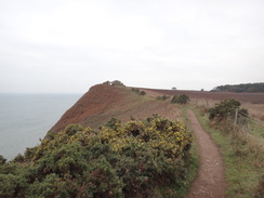
Go through this and follow a hedge on the left. Continue on, passing a couple of low banks that separate fields to reach a third at SY092839, where a track leads off to the right. Pass this and slowly climb across another field, still with the hedge and cliff edge to the left. The path soon curves to the right and then the left to pass Crab Ledge; the gradient levels as it heads towards an old structure above Twopenny Loaf Rock. Pass seaward of this (an old military observation block) and continue on to a pedestrian gate. Go through this and follow the path along the cliff edge, which is relatively level at this point. It curves to the right at Brandy Head and continues southwestwards, soon starting to drop downhill towards Black Head.
Follow an obvious path along the cliff edge; this slowly descends past Danger Point. It then curves to the right and passes a curious hut with TV ariel on the left to reach the cliffs at the eastern mouth of the River Otter. Here the path turns to the right to head northwards with the river on the left; it immediately passes an old concrete pillbox on the left. It climbs up a small hill before descending and climbing once more, always with the river more or less out of view to the left. It crosses a little footbridge over a boggy area of ground and heads on to some steps. Continue on with a hedge on the left towards a pinky-white cottage. The path then descends down to a clapper gate that leads onto a surfaced road. Turn left down the road and immediately pass a car park on the left; when the road forks take the left-hand branch that heads westwards to reach a bridge over the River Otter at SY075830.
Cross the bridge and immediately on the other side turn left through a pedestrian gate to join a good path. Follow this southwards with the river on the left for half a mile; go through a pedestrian gate and continue on with a little stream to the right. It enters a car park with barbecues and a picnic area to the left; keep the car park to the right until you reach the eastern end of Budleigh Salterton's promenade by the mouth of the Otter at SY073819.
Turn right to start following the promenade westwards through the town. The broad stretch of promenade ends at SY066818; here turn left and then immediately right to follow a narrower surfaced path that keeps the cliff edge to the left as it climbs. Climb a few steps and then follow the path as it turns sharply to the left. Keep a wall on the left as the path curves to the right and ends at a T-junction with another path. Turn left along this path and follow it as it almost immediately curves to the right to rejoin the cliff edge. The surfaced path ends at an area of grassland; head across this and climb with the cliff edge to the left.
At the end of the field continue along a path between hedges with the cliff edge to the left. The path starts to climb once more; it becomes rockier as it heads uphill. It passes a bench at the summit of the hill with a golf course to the right before starting to head downhill. Go through a clapper gate and enter a field on the right; follow the path down to another clapper gate and continue downhill. Go through a third clapper gate and down a steep set of steps to reach a footbridge over a stream.
Climb some steps up the other side of the stream's valley to reach a clapper gate. Go through this and enter a field, climbing slightly to reach another clapper gate. On the other side go down a few steps and follow a fence protecting a caravan park on the right. Continue downhill along grass; squeeze through a gap in the hedge on the right near the bottom of the field and head on with the hedge on the left and caravans on the right.
This reaches a surfaced area; head across this aiming for grass ahead; do not head straight on into the military ranges. At the end of the tarmac head uphill across grass, aiming for a hedge at the top of the field. Keep the hedge and fence that guard the shooting ranges to the left. Cross the surfaced track that leads into the military ranges and head on down a surfaced path, still with the fence to the left. This leads into another surfaced area of the caravan park. When the track forks at the bottom take the left-hand branch, still with the range's fence to the left. After a short distance turn right along the edge of a car park.
Pass the entrance of the car park with a slipway leading down to the beach to the left and pass the Beachcomber Cafe and then a car park on the right; the path then curves to the right to reach a driveway leading out of the car park. Turn left along the driveway as it climbs uphill with static caravans on either side. At the end of the road follow a broad surfaced path to reach a clapper gate. On the other side continue uphill with a fence and more static homes to the right. After a short distance turn right through a clapper gate and continue on uphill with a fence and the caravan park still on the right.
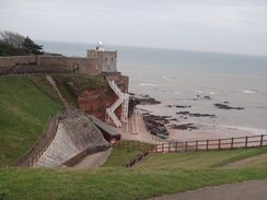
Go through a pedestrian gate and head uphill along a path with a fence on the right. It reaches a summit and continues on downhill. It goes through a gap in a hedge and continues along the cliff edge. It eventually reaches the prominent obelisk monument at Orcombe Point, grid reference SY020795. Do not follow the obvious gravel path away from the monument and instead bear left, following the cliff edge into a little valley and up the other side. It continues along the cliff edge past Rodney Point before joining the gravel path at SY019797. Turn left along the path and follow it as it curves to the left to reach the top of a surfaced path coming up from the left. Turn left and follow this path as it zigzags down the cliff to end at a roundabout beside the eastern end of Exmouth's promenade at SY018797.
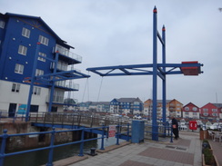
Join the promenade and turn right to start following it westwards. It curves to the right to take a more northwesterly direction; after a mile it reaches the new lifeboat station. Pass landward of this and shortly afterwards turn left to rejoin the promenade. Continue along this for another two-thirds of a mile until it curves sharply to the right to end at a road called Mamhead View. Turn left along this road and as it passes the end of a slipway on the left. Shortly afterwards it curves sharply to the right; here continue straight on down Pier Head. This soon ends; turn right along a path to reach a lifting bridge over the entrance to a marina at SX993806.
Turn left to cross the bridge and on the other side turn left, keeping apartment buildings to the right. The walkway turns to the right to parallel the shore on the left. It soon turns to the right to head away from the sea, heading under a building, then right and left to join a road called Shelly Reach. Follow this and continue on down Camberdown Terrace, passing a long-stay car park on the left. The road curves around and passes Exmouth Rugby Club on the left; shortly afterwards turn left at a roundabout and follow this road as it curves around to the right, passing a car park on the right. Pass the car park and turn right up a road that leads through another car park to reach Exmouth railway station at SX999811.
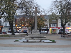
Turn right to pass between the railway station on the left and the bus station on the right. Cross a road in front of the bus station and then take an underpass that heads under the A376 road. When the path forks take the right-hand branch that heads up a ramp that leads towards the city centre. Cross Imperial Road by a roundabout and follow Rolle Street as it curves to the left to head uphill to the southeast, immediately passing some bus stops and the war memorial away to the right. Continue along the road as it steadily climbs for a third of a mile; this walk ends at the Fernside Hotel, which is situated at the junction of Dagmar Road and Rolle Road at SY004805.
 |
 |
|
Distances
| From | To | Distance (m) | Ascent (ft) | Descent (ft) |
|---|---|---|---|---|
| Sidmouth | Budleigh Salterton | 8.0 | 1089 | 1066 |
| Budleigh Salterton | Exmouth station | 6.9 | 1086 | 1109 |
| Exmouth station | Exmouth (hotel) | 0.6 | 62 | 13 |
This makes a total distance of 15.5 miles, with 2175 feet of ascent and 2188 feet of descent.
For more information on profiles, ascents and descents, see this page
Accommodation
We spent the night at the Fernside Hotel in Exmouth, which is situated on a hill about hald a mile southeast of the town from the railway station, although quite near to the southern coast in the town. It was a pleasant place to spend the night and, although not central, was convenient for the town.
Transport
Stagecoach service 157 runs roughly once an hour between Exmouth and Sidmouth, calling at Budleigh Salterton and Exmouth on the way.
 |
 |
|
 |
 |
|
 |
 |
|
 |
 |
|
 |
 |
|
 |
 |
|
 |
 |
|
 |
 |
|
 |
 |
|
 |
 |
|
 |
 |
|
 |
 |
|
 |
 |
|
 |
 |
|
 |
 |
|
 |
 |
|
 |
 |
|
 |
 |
|
 |
 |
|
 |
 |
|
 |
 |
|
 |
 |
|
 |
 |
|
 |
 |
|
 |
Disclaimer
Please note that I take no responsibility for anything that may happen when following these directions. If you intend to follow this route, then please use the relevant maps and check the route out before you go out. As always when walking, use common sense and you should be fine.
If you find any information on any of these routes that is inaccurate, or you wish to add anything, then please email me.
All images on this site are © of the author. Any reproduction, retransmissions, or republication of all or part of any document found on this site is expressly prohibited, unless the author has explicitly granted its prior written consent to so reproduce, retransmit, or republish the material. All other rights reserved.
Although this site includes links providing convenient direct access to other Internet sites, I do not endorse, approve, certify or make warranties or representations as to the accuracy of the information on these sites.
And finally, enjoy your walking!
Nearby walks
| # | Title | Walk length (miles) |
|---|---|---|
| 320 | Lyme Regis to Sidmouth | 16.0 |
| 321 | Sidmouth to Lympstone | 15.3 |
| 322 | Lympstone to Dawlish | 16.0 |
|
|

|