Walk #942: A circular walk from Cambourne to Elsworth and Papworth Everard
 |
 |
|
General Data
| Date Walked | 16/01/2012 |
| County | Cambridgeshire |
| Start Location | Home, Cambourne |
| End Location | Home, Cambourne |
| Start time | 08.50 |
| End time | 14.45 |
| Distance | 17.5 miles |
| Description | This walk sets off from my home in Camkbourne to join the Pathfinder Long Distance Walk at Childerley. It then follows the trail westwards through Knapwell, Elsworth and Papworth Evcerard to reach Yelling, where the trail is left behind and a bridleway heads south to Eltisley. Another bridleway then heads east back to Cambourne. |
| Pack | Today I carried my 30-litre Karrimor rucksack, filled with water, my waterproofs, a book and other odds and ends. |
| Condition | I am in a fairly poor state after this stroll. My feet are in a bad state, with several blisters where I do not normally get them. I was also fairly exhausted by the end of the day, and chose not to extend the walk. |
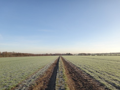
| Weather | Today dawned bright and sunny, although with a consequenty heavy frost on the grass. It barely warmed up all day, and patches of fronst could be seen in sheltered places all day. It was a lovely day for a walk, especially as there was not much of a breeze. |
| OS map | Landranger number 153 (Bedford & Huntingdon, St Neots & Biggleswade) and Landranger number 154 (Cambridge & Newmarket, Saffron Walden) |
 |
 |
|
Map of the walk
Maps courtesy of Google Maps. Route for indicative purposes only, and may have been plotted after the walk. Please let me have comments on what you think of this new format. For a detailed table of timings for this walk, please see the table file.
 |
 |
|
Notes
It has been a couple of months since my last walk, life having rather got in the way over the Christmas and New Year periods. I did not fancy driving a long way for todays walk, and instead I decided to reinstate an old tradition and walk from our house - I always try and do at least one walk from every house I live in. There is a named trail a couple of miles to the north of our house in Cambourne - the Pathfinders Long Distance Walk, which visits a number of old airfields in the area.
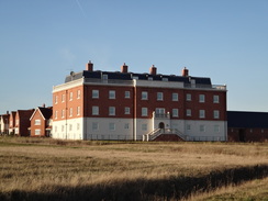
It had been the coldest night of the winter so far and a thick layer of frost covered the ground and the roofs. Cambourne is a new development, first started in 1998 to act as a satellite village for Cambridge. So far it has been a qualified success despite the fact that construction has not yet been completed. I walked along familiar paths down past what has to be one of the worst faux-Georgian buildings ever constructed; the windows, chimney and roof are all out of proportion making it look, to my mind at least, hideous.
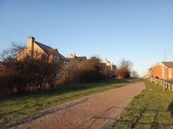
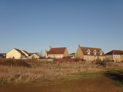
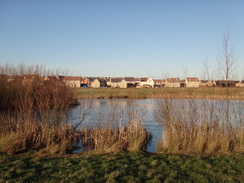
Good paths run around the perimeter of the village and my route took me past a couple of lakes - Whomping Willow and Sirius - showing the period in which the village was designed. Signs of construction could be seen in places, especially in Upper Cambourne which has yet to be completed, including dumper trucks and diggers on the road. The construction has far outpaced the Ordnance Survey, and my 1997-vintage 1;50,000 map shows fields and a solitary farm where thousands of houses now sit. This would make navigation for most people difficult; fortunately I have been living in the village for a year and know the roads and paths well.
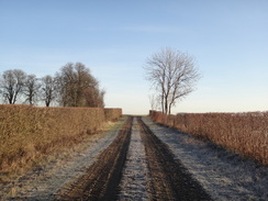
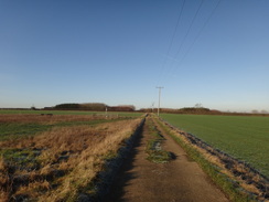
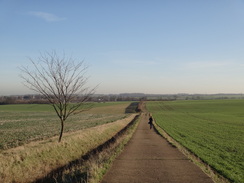
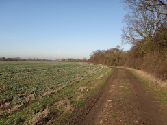
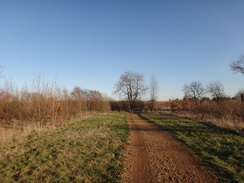
A bridge took me across the A428(T) dual carriageway - also not marked on my maps - to the old road that it replaced, after which a bridleway took me northeastwards. This was wide with ditches and hedges on either side and was a classic unadopted byway. When the national road network were improved and surfaced in the twentieth century some traditional routes were abandoned. This seemed to be the case with this track, and it was easy to imagine carts travelling down it in Victorian times. The hedges ended and the track became more open as it passed a farm and climbed up towards Childerley.
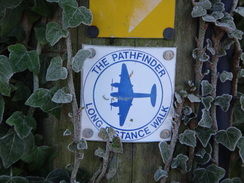
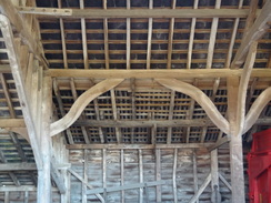
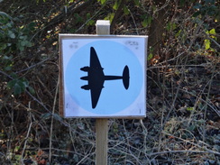
This settlement is little more than a farm, but a rather pleasant one nonetheless. Many of the buildings were attractive and some of the open-fronted barns had elegantly-carved framing. Bumps and hollows in nearby fields denote the site of the medieval village of Great Childerley, whilst the farm is based around the villages old hall. I joined the Pathfinder Long Distance Walk in the farmyard and saw my first waymarker for the trail in the form of a silhouette of a twin-engine Mosquito plane.
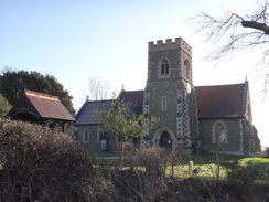
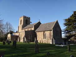
Tracks took me north out of the farm before paths and tracks took me westwards across a road to reach the hamlet of Knapwell. Despite having lived in Cambridgeshire on and off for fourteen years and having walked, cycled and driven extensively in the county, this was a village I had never visited before. There was not much to it; just a few houses strung along a minor road with a church at the northern end.
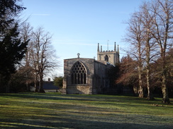
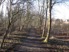
I came across the first gate of the day leaving the village, but this led to a good track that took me northwestwards into Elsworth. I passed the church before joining a road that headed out of the village. More tracks took me westwards and for the first time today I saw other walkers - a jogger and a few men walking between the two villages. The track was left as it approached the village of Papworth Everard and took a more winding route into the village, including a stretch through some woods.
Papworth Everard is dominated by a hospital, which a couple of weeks before had housed Prince Phillip as he underwent a heart operation. The hospital is famous as the place where Britains first heart transplant operation was undertaken, and it has pioneered such operations ever since. The main road through the village is the Roman Ermine Street; until recently the road was very busy, but a recently-constructed bypass has granted the village a much quieter countenance. It is very much dominated by the presence of the hospital and a number of people in wheelchairs were being pushed along the wide pavements.
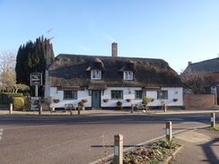
I nipped into a shop to buy some spare batteries before following the trail out of the village. It climbed up past some shabby housing (including a lovely thatched cottage that was sadly abandoned) before dropping down into a little valley and climbing up the other side. At the top I came across another area where my maps were out of date - the Papworth Everard bypass had opened a couple of years earlier. This is the road that I frequently use to reach all points north; as such it was a surprise when I got slightly confused about the direction due to the presence of an old road. Eventually I found the correct route and made my way to the minor road that headed westwards towards the hamlet of Yelling.
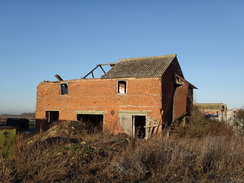
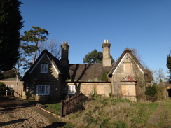
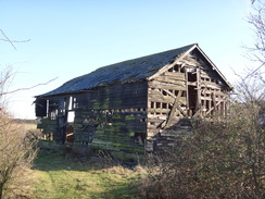
My feet and legs were starting to ache by now, which is unusual after such a short distance over good terrain. This was possibly due to the long gap since my last walk, but it was clear that things were not going to get much better. Fortunately after reaching the church in Yelling I left the trail and headed back a short distance to join a bridleway that headed south across fields. The going was good but the firm surface did not really help my feet. Fairview Farm beside the track was in poor condition - most of the barns had fallen down and the farmhouse itself had glassless windows although the roof was still mostly intact. This was a shame but the reasons are obvious - access to the remote farm is difficult.
The track followed a winding field drain to reach the A428(T) once more. There have been plans to dual this single-carriageway stretch of road, but the work has yet to be approved and so the narrow road is fairly busy. A gap in the traffic soon came and I jogged across to reach the Eltisley church. This is a particularly picturesque village with a large, triangular village green. A large tree with a semicircular bench around the base was planted in commemoration of the men form the village who died in the First World War; nearby there is a cafe that was sadly shut.
The good morning was turning into a stunning afternoon; most of the chill had gone and there were few clouds in the sky. A track took me eastwards along Caxton Drift, which is also believed to be another old Roman road; again it was been adopted as a public road in the twentieth century. It is easy to believe that it was a Roman Road as the green lane was arrow-straight until an area called The Moats was reached. This was heavily overgrown with scrub, but a handwritten sign pinned to a stile gave some of the history; the site was a medieval manor that was abandoned as long ago as the 1500s.
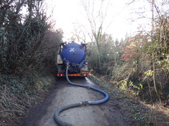
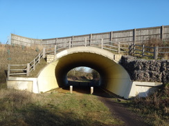
Another track took me east to reach the A1198 in Caxton. This was another road that had been bypassed recently and was far quieter than I remembered. The pub up the road looked inviting but I was very near home now and my feet were aching more than ever. Instead I took the Crow Dean track. A slurry lorry was pumping out a nearby sewage farm and I had tosqueeze past it and its pipes that snaked further down the track. Soon the path passed under a bridge that carries the bypass overhead on the approach to the outskirts of Cambourne.
It had been my intention to follow the track to the centre of the village, but my aching feet made me decide to follow the perimeter track back towards my house. It is a pleasant walk and it is good to see developers creating such paths and tracks in a new development. I arrived back at my house muddy, tired and very footsore. It had not been a classic walk, but despite this had been well worth doing.
The Pathfinders
Heavy losses over Germany in the Second World War led the RAF to move to night time, rather than daylight, bombing. This doctrine shift led to problems in targeting and highly inaccurate bombing. Various attempts were made to offset this with varying levels of success.
To improve matters, the RAF created 8 Group in 1942 as a team of highly experienced airmen and navigators skilled in using the latest radio direction technologies; they soon became known as the Pathfinder Force. They flew from various airfields in Cambridgeshire such as Warboys and Oakington. Their planes would lead attacks into Germany and drop flares onto the target areas, allowing the following planes to find the target. Initial results were poor, but techniques and accuracy soon improved.
A 46-mile long-distance trail, the Pathfinders Long Distance Walk, visits many of the airfields that the Pathfinders flew from. An annual walk, the Pathfinders March, follows the course of the trail in memory of the RAFs Pathfinder force, usually in the midsummer.
 |
 |
|
Directions
This walk starts off from my house in Cambourne at approximate grid reference TL318589; some directions below show the route from the supermarket in the centre of the village to my house.
Head down Foxhollow until some black gates are reached on the left. Go through these and follow a wide gravel path down to another set of gates that guard Jeavons Road. Cross the road, go through more gates and down a shorter stretch of gravel path to a fourth set of gates. This leads out onto an area of grassland with a large faux-Georgian house to the right. After a few yards a path junction is reached; here turn half-right to head past a small brick-built waterworks building on the left.
Shortly after passing the brick building the path ends; join a rough footpath across grass that curves to the left as it descends towards Whomping Willow lake. It skirts to the right of the lake and soon joins a wider, official path that follows the lake edge. Eventually the lake is left behind and the path heads on; it climbs a few feet to reach a concrete haul road. Cross this and follow the path on the other side. It immediately crosses a bridge over a ditch before continuing with a hedge on the right.
The hedge on the right peters out but the path continues on. It crosses another path and heads on with the teardrop-shaped Sirius Lake to the left. When the lake ends the path climbs slightly to cross another path; continue on with a hedge and ditch to the right. The path soon becomes a pavement with Brace Dein Road to the left; it passes a school on the right and a village green on the left before it ends at a T-junction. Cross the road ahead and continue straight on along a surface track, passing a small car park on the right.
Continue straight towards an aerial ahead; as the surfaced track veers to the right towards some gates leading to allotments, turn left past a wooden gate to join a path that runs between hedges, still aiming for the aerial. Soon the path curves to follow a concrete track that heads up to reach a road called Broadway. Immediately turn left to follow the road as it climbs to cross a bridge over the A428(T) dual carriageway. On the other side it ends at a T-junction with the old A428(T) at TL335599.
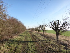
Turn right and carefully follow the road eastwards, passing a lay-by on the left and covered reservoir on the right. After a few yards, opposite an old road entrance on the right, turn left to join a byway. Initially this is surfaced as it passes some round tanks on the right; when the surfaced track heads into the compound on the right continue straight on along the unsurfaced byway. This passes between hedges as it heads northeastwards for two-thirds of a mile; the hedges broaden out before the track starts to wind as it climbs uphill.
It then heads between well-cut hedges as it passes Birds Pastures Farm on the left; the hedges end at a track leading to the farm. Cross the farm track and follow the path as it curves to the left and then right to head away from the farm along a track with a hedge on the left. Soon afterwards it curves to the left and right once more to cut eastwards between two fields. It passes through a gap in a hedge to cross another field; it is easy to follow. The track ends at a surfaced road in Childerley at TL354614.
Turn left to follow the track northwards, immediately passing a pond on the right. Soon the track curves to the right to pass farm buildings on the left. Just before the main farmhouse is reached turn left up another track; this marks the point where this route joins the Pathfinders Long Distance Walk, which will be followed as far as Yelling. The track heads north between barns before curving to the left and then right to pass several barns on the left. At the end of the barns turn left past the end of the barns; immediately after passing the last barn the track then curves to the right.
The track follows a hedge on the left as it heads towards some power lines ahead. As the track starts to gently curve to the left, turn left through a gap in a hedge that follows a path along the edge of a field, following a hedge on the left. Go through a gap in the hedge at the end of the field and cross a plank footbridge to reach another field. Follow a hedge and ditch on the right; at the end of this second filed go through another gap in a hedge to join the end of a concrete track. Follow this westwards until it reaches a minor road.
Cross the minor road and continue straight on along a green track called Thorofare Lane. This passes several patches of woodland on either side of the track; after 0.7 miles it ends at a T-junction with another road in Knapwell at TL333624. Turn right to follow the road northwards through the village for 250 yards. Shortly after passing Hope Farm on the left, turn left down a footpath. Go through a clapper gate and pass a barn on the left. The path curves to the left for a few yards and then to the right to reach another clapper gate that leads into a field. Head straight on across the field with power lines to the right, aiming to join a hedge on the left.
Follow the hedge on the left; when the field ends join a track and follow this with a hedge still on the left. The track heads under the power lines; as it curves sharply to the left head straight on across a corner of the field to rejoin the track about fifty yards further on. The track continues in a rough westerly direction before curving to the right, still following a hedge on the left. It then curves slightly to the left to head towards a caravan park. It passes a fence on the right as it enters the caravan park; this soon ends as the path joins a track in the park. Follow this as it heads downhill, becoming a road as it passed Elsworth Church on the left. Soon afterwards the road ends at a T-junction in the village at TL318637.
Turn left to start following the road westwards through Elsworth. Follow the road as it crosses a deep ditch and then join a pavement on the right-hand side. It passes playing fields on the right and the Poacher pub on the left. When the road curves sharply to the right, head straight on along a track. This soon curves to the left, following a hedge to the left. Soon afterwards it curves to the right, climbing uphill to the southwest. Before a clump of trees are reached the track becomes concrete, soon afterwards turn right along another concrete track that heads westwards. This descends into a little valley before ascending the other side.
The track crowns the top of a low hill; as the concrete track curves to the right head straight on along a green track between fields. It jinks to the right and then the left; shortly afterwards it curves to the right beside a little pit and then the left to head towards some trees. When the trees are reached, turn left past the end of a little ditch to follow another ditch downhill. The ditch is soon replaced by an area of woodland.
At the bottom of the hill turn right (do not enter the trees), keeping the woodland to the left. Soon the field ends and the path plunges through the trees before curving to the right, with the woods to the right and a hedge and houses to the left. The path heads north through the trees past houses and crosses a couple of footbridges over ditches. When a path crossroads is reached with a field to the right, turn left along another footpath that heads through trees. This leads out onto Hamden Way in Papworth Everard. Turn right down the road and follow it as it curves to the left, descending gently downhill past some tennis courts before ending at a T-junction with Cheques Lane. Turn left down Chequers Lane until it ends at a T-junction with Ermine Street in Papworth Everard at TL284631.
Turn left to follow the main road southeastwards through the village for a fifth of a mile until Church Lane is reached on the right. Turn right up Church Lane and follow it as it heads uphill. When the road ends with Paworth Everard church to the left, turn half-left to take a footpath that heads steeply downhill across a field. At the bottom it crosses a small ditch and continues on, keeping a fence and hedge to the right uphill. When the hedge on the right ends continue straight on across the field, aiming for a fence and lampposts ahead. At the end of the field cross a concrete track and go through a gate in a fence. Turn slightly to the right to reach the Papworth Bypass.
Carefully cross the bypass and take a bridleway on the other side. This soon curves to the left, keeping a fence on the right to reach a junction with an old road; here turn right along a minor road. Follow this road westwards for a little under a mile; it falls and climbs a couple of times before entering the village of Yelling. Continue on until Yelling church is reached on the right at TL262624. Here the route leaves the Pathfinder trail.
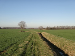
Retrace your steps back along the road for a couple of hundred yards until a bridleway leads off down a driveway to the right. As the driveway curves right towards a house continue straight on along a green lane. This heads south across fields, joining a track as it does so. When the track splits continue straight on, following a hedge on the left. It passes under some power lines; at the end of the very long field go through a gap in the hedge ahead; it immediately crosses a little drain and continues on between hedges.
The track passes the ruined Fairview Farm on the left and continues southwards. Go through a pedestrian gate at the end of the field and on the other side follow a hedge on the right. When this ends follow a deep ditch on the right, heading for the tall spire of Eltisley church ahead. The path crosses the ditch on a land bridge and follows it on the left to reach double field gates that lead onto the A428(T).
Carefully cross the main road and go through a bridleway gate beside another couple of field gates. Follow a path with a hedge on the left; after about thirty yards the path passes through an open gate and continues on to emerge onto The Green in Eltisley at TL268597. Turn left to follow the road past the church towards the village green. Just before the green, take the first road off to the right to keep the green on the left. When the road reaches a crossroads, head straight on down Caxton End.
This passes a school on the right and continues southeastwards. It passes Jesus College Farm on the right before curving to the left to take a more easterly course, now as Caxton Drift. When the surfaced track curves to the right continue straight on along a green lane that runs between hedges. A mile after the farm the track curves to the left beside a wooded area, the site of some old moats associated with a long-gone medieval manor.
Follow the track as it runs between hedges, with the old moats off to the right. It crosses a track leading into the scrubland, and then turns left and then right for a few yards to cross a stream. Continue on with the wooded area to the right and a field to the left. Shortly after leaving the moats behind, the track starts climbing eastwards between hedges. Go past a vehicle barrier and continue on; the track becomes surfaced as it descends to meet a road in Caxton. Turn left down this road for a few yards until it ends at a T-junction with another road in Caxton at TL302586.
Turn right to follow the road south through the village; after a short distance it crosses a bridge over a stream. Immediately after this turn left along a track which is initially surfaced. When the surfacing ends continue straight on along Crow Dean track. This eventually heads under a bridge that carries the new(ish) Caxton bypass overhead. Shortly afterwards the boundary path around Cambourne is reached at TL309590.
Turn right to start following the wide path southeastwards up a slight slope, with a small hill to the left and a hedge to the right. It crests the slope and starts to fall. When the path ends at a T-junction, turn left along the new path towards the Whomping Willow lake, where we rejoin the route followed earlier.
As the track curves to the right past the lake, turn left along a rough path that climbs and curves to the right towards a faux-Georgian building. The path ends at a track. Follow this past a small brick building on the right and then turn left up a path. Go past some gates and follow a short path up to a second set of gates. Cross Jeavons Road on the other side and continue past a third set of gates onto a longer gravel path that heads to a fourth set of gates that lead onto Foxhollow. Turn right to follow Foxhollow back towards the start of the walk.
 |
 |
|
Distances
| From | To | Distance (m) | Ascent (ft) | Descent (ft) |
|---|---|---|---|---|
| Home, Cambourne | Childerley Hall | 3.7 | 75 | 112 |
| Childerley Hall | Yelling church | 7.8 | 377 | 373 |
| Yelling church | Home, Cambourne | 6.0 | 164 | 131 |
This makes a total distance of 17.5 miles, with 616 feet of ascent and 616 feet of descent.
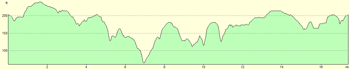
For more information on profiles, ascents and descents, see this page
 |
 |
|
 |
 |
|
 |
 |
|
 |
 |
|
 |
 |
|
 |
 |
|
 |
 |
|
 |
 |
|
 |
Disclaimer
Please note that I take no responsibility for anything that may happen when following these directions. If you intend to follow this route, then please use the relevant maps and check the route out before you go out. As always when walking, use common sense and you should be fine.
If you find any information on any of these routes that is inaccurate, or you wish to add anything, then please email me.
All images on this site are © of the author. Any reproduction, retransmissions, or republication of all or part of any document found on this site is expressly prohibited, unless the author has explicitly granted its prior written consent to so reproduce, retransmit, or republish the material. All other rights reserved.
Although this site includes links providing convenient direct access to other Internet sites, I do not endorse, approve, certify or make warranties or representations as to the accuracy of the information on these sites.
And finally, enjoy your walking!
Nearby walks
| # | Title | Walk length (miles) |
|---|---|---|
| 10 | Waterbeach to Great Chesterford via Cambridge | 21.0 |
| 108 | Waterbeach to Huntingdon | 21.6 |
| 119 | Huntingdon to St Neots | 11.8 |
|
|

|