Walk #292: Ramsgate to St Margaret's at Cliffe
 |
 |
|
General Data
| Date Walked | 10/12/2002 |
| County | Kent |
| Start Location | Ramsgate |
| End Location | St Margarets at Cliffe |
| Start time | 08.09 |
| End time | 14.58 |
| Distance | 17.7 miles |
| Description | This was a nice walk southwards from Ramsgate, taking in the lovely towns of Sandwich and Deal. |
| Pack | Today I carried my 30-litre Karrimor HotRock rucksack, which was filled with my packed lunch, waterproof leggings, water bottle and a couple of spare shirts, together with the usual assortment of odds and ends. |
| Condition | I am fine after this walk, and could easily have walked further if the need had arisen. My ankle did not give me as much trouble as it did yesterday, but it is still far from being perfect. |
| Weather | Today was a little (although not much) warmer than yesterday, and it was much cloudier, and I did not see the sun at all. Fortunately there was no sign of any rain until later in the evening when I was safely ensconced in the van. It was very windy at times, and the climb up towards St Margaret's at Cliffe was very windy, so I was forced to use my walking poles for the first time in weeks. |
| OS map | Landranger number 179 (Canterbury & East Kent, Dover & Margate) |
 |
 |
|
 |
 |
|
Map of the walk
Maps courtesy of Google Maps. Route for indicative purposes only, and may have been plotted after the walk. Please let me have comments on what you think of this new format. For a detailed table of timings for this walk, please see the table file.
 |
 |
|
 |
 |
|
Notes
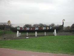
As I was walking towards Cliffs End to meet the A265 road I came across a Viking Boat perched on concrete pillars. This is the 'Hugin', a replica Viking boat that in 1949 was sailed over from Denmark in 1949 by 53 Danes and landed at Viking Bay in Broadstairs. On the foreshore are the concrete remnants of the International Hoverport. This was opened in 1969 and was used for the massive SRN4 hovercraft that could carry 55 cars and 400 passengers at speed of up to 60 miles per hour. In 1983 services from the bay stopped, and the area is now overgrown and looks very derelict.
During this walk we have been using the poste restante system, which is a system that the post office provides that allows mail to be picked up. My dad parcels any post for the two of us and sends it on to a nearby office for collection. He did this last week, with two parcels for collection in Sittingbourne, butt as of yesterday it had not arrived well over a week after posting. Today dad got the first parcel back, and it was stamped not at this address. Instead of keeping the parcel as they should have done, they had sent it back. This is very highly annoying especially as post restante is a service that you pay for. Dad has complained to the royal mail as the post office in Sittingbourne have plainly not done their job (they admitted that they did not know what the poste restante system is, so they sent it back to sender), and they are sending him some compensation. Hopefully the other parcel will turn up tomorrow, and then my brother can bring them down with him when he visits at the new year.
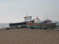
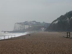
Sandwich and Deal were both lovely towns, and as I passed through Sandwich I could not resist the temptation to eat a sandwich. There are some beautiful buildings in the town, and I took several photos of some of them. Deal was also nice, and it does not have a quay so it has boats hauled up on the shingle beach, which looked marvellous and a great seaside scene.
I had arranged to meet Sam in Deal so that she could cook me some soup. By the time I got there I was warm enough, however, but I did really want the toilet. I met Sam and then went into the nearest pub, the Star and Garter Hotel, for a quick pint and to use their facilities. Unfortunately Sam could not find a parking space near to the pub, so she waited for me about a third of a mile away, and I met her afterwards. The people in the hotel were very nice, and the landlady kindly gave me some money for the charity.
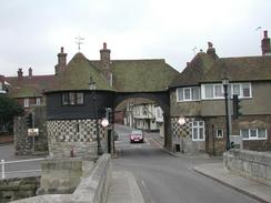
I was not really sure where I was going to end the walk, so Sam was waiting for me by the Zetland Arms at Kingsdown. I was still feeling fighting fit, and so I decided to walk on further. The next available place to meet was at the beautifully named St Margaret's at Cliffe, so we arranged to meet there. As I was approaching the memorial to the Dover Patrol which is to the north of the village I got a phone call from Sam telling me that she was waiting at the memorial. It turns out that she had attempted to get the van down the hill but had met a car halfway down. It was incredibly steep, and she had to reverse back up the hill that she found very difficult, and was made more difficult by the impatient actions of some other drivers. The memorial itself is a quite nice obelisk, dedicated to the memory of the sailors who died in the Dover Strait during both world wars.
Directions
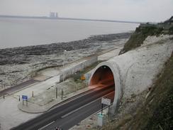
This walk starts off at St Benedicts Lawn in Ramsgate. Head downhill to the main road, and then turn right along the main road. When the main road turns to the right after a short distance continue straight on down a road. At this road turn to the left cross a grassy area to a path that runs at the top of the cliffs. Follow this path as it heads westwards, passing over the entrance to the A253 Pewgwell Tunnel, before the path ends at a fence. Here turn right to head north up another path beside the fence until it ends at a road.
Turn left down this road and follow it as it heads southwestwards through Pegwell. When the road turns to the right follow it around the bend and take a footpath that heads off to the left. This footpath leads down a rough track between some houses before emerging onto the cliff top. Follow the cliff top path as it heads in a roughly westerly direction as the cliffs descend before the path ends at the A256 road beside a prominent Viking boat on a grassy area to the left.
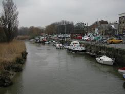
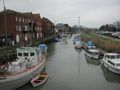
Turn left and follow the combined cycle path and footpath that follows the left-hand side of the road southwestwards. The path is surfaced and the going is good as it passes the disused Ebbsfleet power station and slowly turns to head in a more southerly direction. When a roundabout is reached continue straight on down a road that heads southwards for a couple of kilometres, passing through a chemical factory before eventually crossing the river in Sandwich.
Cross over the narrow bridge and on the other side turn to the let to head down the quayside through a car park. At the end of a car park continue straight on down a surfaced path until a little metal bridge is reached on the left. Cross this bridge and on the other side continue straight on down a poorly surfaced path that heads northeastwards along a bank, skirting the southern bank of the river before it reaches a sluice. Cross a drainage channel at the sluice and descend down onto a road at a bend on the other side.
A footpath leads off to the right at the bend, heading across a field and passing immediately to the south of New Downs Farm. The path is very distinct on the ground, and heads in a more or less straight direction for about a mile until it reaches a surfaced track by a building beside the Prince's golf course. Turn right and join the track as it heads southwards, passing through a car park and continuing on until it reaches the large houses of the Sandwich Bay Estate. Follow the track as it heads through the estate past the shingle bank until it ends at the southern edge of the estate.
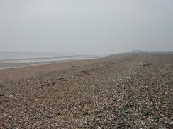
From here there is a footpath that heads southwards immediately to the landward side of the shingle bank. I started by walking along the top of the bank, but the shingle made for hard going in the strong winds so I dropped down onto the footpath. The footpath skirts the Royal Cinque Ports golf course until it eventually emerges at the northern outskirt of the town of Deal.
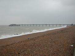
Join the seawall that heads south along the seafront through the town. After a little over a kilometre pass Deal Pier and continue on southwards until the RNLI station is met. Here the path heads slightly more inland along a good, surfaced path at the edge of the shingle beach. The path passes Walmer Castle and continues on southwards into the little village of Kingsdown.
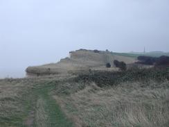
When the Zetland Arms pub is reached in the village turn right up a road until it end at a T-junction with another road after about a hundred yards. Turn left down this road and follow it southwards to Oldstairs Bay. When the road curves sharply to the right to head uphill take a footpath that leads off up steps to the left. These steps lead up the hill onto a grassy path that leads southwards near an aces road to some houses. The path descends slightly as it follows the cliffs before climbing once more to reach a summit at the Dover Patrol Memorial, just to the north of the village of St Margaret's at Cliffe.
Distances
| From | To | Distance (m) | Ascent (ft) | Descent (ft) |
|---|---|---|---|---|
| Ramsgate | Sandwich | 6.5 | 131 | 233 |
| Sandwich | Deal | 6.4 | 49 | 49 |
| Deal | St Margaret's at Cliffe | 4.8 | 1247 | 948 |
This makes a total distance of 17.7 miles, with 1427 feet of ascent and 1230 feet of descent.

For more information on profiles, ascents and descents, see this page
Accommodation
Yet again there were no suitable campsites nearby open at this time of year, so we parked on the roadside in St Margaret's at Cliffe near the church.
Disclaimer
Please note that I take no responsibility for anything that may happen when following these directions. If you intend to follow this route, then please use the relevant maps and check the route out before you go out. As always when walking, use common sense and you should be fine.
If you find any information on any of these routes that is inaccurate, or you wish to add anything, then please email me.
All images on this site are © of the author. Any reproduction, retransmissions, or republication of all or part of any document found on this site is expressly prohibited, unless the author has explicitly granted its prior written consent to so reproduce, retransmit, or republish the material. All other rights reserved.
Although this site includes links providing convenient direct access to other Internet sites, I do not endorse, approve, certify or make warranties or representations as to the accuracy of the information on these sites.
And finally, enjoy your walking!
This walk was mentioned in the following routes:
| My walk around the coastline of Britain |
Nearby walks
| # | Title | Walk length (miles) |
|---|---|---|
| 291 | Reculver to Ramsgate | 17.4 |
| 293 | St Margaret's at Cliffe to Hythe | 17.1 |
|
|

|