Walk #828: A circular walk from Cranborne
 |
 |
|
General Data
| Date Walked | 31/01/2009 |
| County | Dorset, Wiltshire |
| Start Location | Cranborne |
| End Location | Cranborne |
| Start time | 07.58 |
| End time | 16.06 |
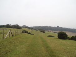
| Distance | 21.9 miles |
| Description | This was a pleasant circular walk heading northwestwarsd from Cranborne. |
| Pack | Today I carried my 30-litre Karrimor rucksack, filled with waterproofs, a flask and other odds and ends. |
| Condition | I am tired after this walk and have a couple of little blisters on my toes, but aside from these I am fine. |
| Weather | Today was a cloudy day that offered few glimpses of the sun. It was not a cold day, but the breeze was fiercely cold when I was exposed to it. |
| OS map | Landranger number 195 (Bournemouth & Purbeck, Wimborne Minster & Ringwood) and Landranger number 184 (Salisbury & The Plain, Amesbury) |
 |
 |
|
 |
 |
|
Map of the walk
Maps courtesy of Google Maps. Route for indicative purposes only, and may have been plotted after the walk. Please let me have comments on what you think of this new format. For a detailed table of timings for this walk, please see the table file.
 |
 |
|
 |
 |
|
Notes
I had not done a walk for over a week, and I had not yet reached my target of walking 100 miles in January. Therefore last night I quickly planned out this walk. I wanted to revisit the spectacular Bokerley Ditch, which I passed on the last walk, and this would also mean that the drive would not be too long. After the parking problems that I had in Coombe Bisset, it was a relief when I discovered that Cranborne had a small public car park. The weather forecast had been for sunny periods, and although there had been a red sky during the drive, the sun was absent as I started walking.
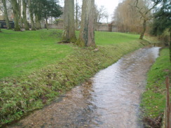
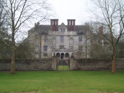
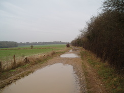
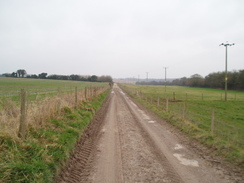
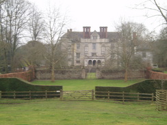
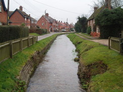
Cranborne is a lovely little village. It has a fire station slap-bang in the centre, and as I had taken lots of food with me I did not bother going into the shop to get any food. It proved easy to find the path that led westwards out of the village; for the first few miles I would be following the Jubilee Way. The path passed near to a magnificent house on the left, Cranborne Manor. Shortly after this a footbridge took me across the River Crane. The river at this stretch is very pretty, narrow and clear, with grassy banks leading down to the edge.
The path climbed uphill to the west to meet a road; the views were spoilt by a general haze in the distance. I scoffed down a couple of bananas as I followed this road. After the road the path followed field boundaries (also joining the Hardy Way) before joining a track called Ringwood Lane. On this stretch I went over on my left ankle slightly; nothing serious, but it troubled me slightly for the rest of the day. I had twisted that ankle a few week's previously, and it was the last thing I needed so early on in the day. This was a pleasant stroll, although any views were spoilt by a general haze in the distance. When this meets a road the Jubilee Way headed off slightly uphill for a few hundred yards before reaching Monkton Up Wimborne; instead of doing this, I yomped along the road. To the left was a river with beautiful clear water; in my first glance into it I saw a large fish - possibly a brown trout.
A couple of years ago I used to walk with an aim of completing 12 miles by midday, and today I was very near being able to achieve that, The moment that I decided that I could do it, I forced myself on harder. It was good to be yompng once again, although my breathlessness showed how out of shape I was.
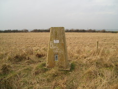
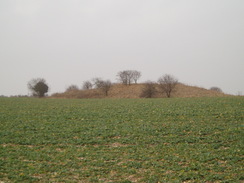
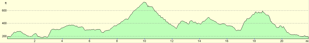
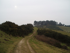
The path then ascended a hillside, and a good track took me northwestwards along Harley Downs. Again the views were spoilt, so I just keept my head down and walked on. The path crossed an old Roman Road in some trees at Harley Gap; the mud here was quite thick, but afterwards it was fine. At Harley gap there was a memorial stone with snowdrops scattered about; a pleasant sight. There was a trig pillar a little distance away to the left, so I diverted off here to go and visit it. Near here were several barrows and long barrows, and this seemed like a very good place to be buried.
A descent took me down to the A354 road, then a long road along tracks took me down to another road at Dean, where I left the Jubilee Way. After this a path led northwest across Woodcutts Common; the ground here was lined with lots of bumps and hollows from what, according to the map, might be the site of an old settlement. Certainly it would not surprise me.
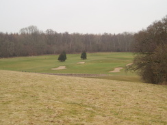
Next the path crosses a neat golf course; I took care, then started walking along the boundary of the course. Unfortunately it turns out that I should have taken a path that headed slightly to the right through the trees; this meant that I had to walk along he boundary of the golf course for longer than was ideal. At the very corner of the golf course I jumped over a fence and rejoined the proper track.
This took me on past a fairly imposing gateway that leads to Sandroyd School, which was out of sight a long way to the southwest. From here my route took me up the driveway, on either side of which, at regular spacings, are large square patches of trees - this made a pleasant change from the usual avenue of trees. The climb did not feel particularly steep, and I was soon exposed once more to the fierceness of the breeze. It was therefore a relief when my route took me back into the protection of the trees. This was the start of a long and slow descent, heading southeastwards through Chase Woods.
About halfway along I heard a long ten second low rumble, like a chainsaw starting up. It dipped in tone, then increased. I took my walkman earphones out of my ears just before the sound ceased, and my heart stopped; it sounded just like a cat's purr, but was much louder. I looked around and can see nothing, and there was no other sounds aside from a couple of guns going off in the distance. I have no idea what caused the sound, but it didn't half make me jump!
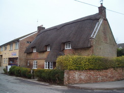
As I exited the forest I reached my target of 12 miles by midday, and to celebrate I sat down to eat my lunch. I did this just as the footpath left an access track that led to some houses. Nearby was an old house that was being renovated and extended, and just as I finsihed the first cup of tea out of my flask a car roared up. I felt rather self-concious sitting on the verge, but the man said nothing as he entered the house, walked around the top of the scaffolding then, before I had finished the last of the tea, roared off once again.
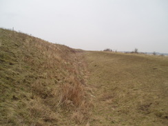
The next stretch took me over a hill and then down through Pribdean Wood, where there was a car park at the bottom, then on towards West Woodyates Manor. A sign here denoted that the track beyond was private, so I headed uphill to head northwestwards along a rather undistinguished stretch of path. On the way this passed over the course of the Bokerley Ditch, although there was no trace of it on the ground. This led down to a road, which I followed down to Woodyates. When this crossed the Bokerley Ditch, the ditch to the left was clearly visible, yet the stretch to the right in the field appeared to have been totally dug out. Unfortunately you cannot walk this stretch of the ditch, which is a shame.
In Woodyates I crossed the A354 once more. By the bus shelter on the road there was a stone memorial for the Trafalgar Way, which was the route taken by Lieutenant Lapenotiere in 1805, when he carried the first news of the victory at the Battle of Trafalgar from Falmouth to London. The change of horses at Woodyates was the thirteenth of the trip, and cost £2 and 5 shillings. The entire trip to London of 271 miles took him 37 hours.
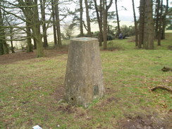
Another path took me east towards Bokerley Ditch; a Romano-British defensive ditch that dates back to 367 CE, and was constructed to keep the Saxons out of Dorset. I had been looking forward to this stretch of the walk, and for the first part I actually walked on top of the bank, enjoying the views that the extra little height gave me. However the path along the top was relatively rough and narrow, so I soon dropped down and started walking along the proper path, which runs alongside the ditch. I had been hoping that the weather would be sunny today so that I could get some better photographs; unfortunately, that was not to be, so I contented myself with some snaps as I followed the ditch downhill, then started climbing again.
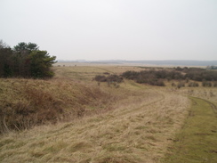
Soon I reached the point that marks the start of the Jubilee Trail, although I could see no marker denoting that fact - it is odd that a named trail starts in the middle of nowhere. This led me up a muddy bridleway, narrow and constrained on both sides by overgrown hedges. It was a relief when the path opened out and the gradient slackened. This led to a lovely little walk along the top of Pentridge Down. Here I met a woman and young boy, who pointed me towards smoke rising up from the village of Pentridge below. Apparently a thatched roof had caught fire, and there were at least seven, perhaps nine, fire engines in attendance. We chatted for a few minutes, and then I continued on.
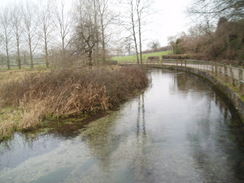
I diverted off to visit the trig pillar on Penbury Knoll, which is situated within a little area of trees. The views from here would have been superb had it not been for the haze. After this a long descent followed south along bridleways, eventually reaching Cranborne Farm. From here a track took me alongside the River Crane and back into Cranborne. I had a little more trouble with my left ankle on this stretch, with some fairly intense jolts of pain that vanished almost as quickly as they had come.
It was a relief to get back to Cranborne; I felt fit, but had definitely had enough of the day. I got into my car, and chose to drive a rather indirect but beautiful route back across the New Forest to the north of Ringwood. It had been a good walk, although rather spoilt by the slightly dismal weather. On a sunny day, it would have been superb.
Unfortunately when I got home I discovered a problem - my GPS, which has behaved itself for ages, suddenly refused to let me access today's GPS log. A quick inspection showed that it was a very small file, and corrupt. I have no idea why this occurred, and a test the next day showed a perfect log. It was a minor irritation on an otherwise good day.
 |
 |
|
 |
 |
|
Directions
This walk starts off at the car park in Cranborne. Leave the car park and walk westwards, keeping the fire station on the right. As the road swings around to the left continue straight on. Pass a shop on the left, then walk past the 'Sheaf of Arrows' pub. Here turn half-left along a little lane to join the Jubilee Trail, which will be followed for the first few miles. Pass the church on the left, and keep a hedge on the left. Walk past Cranborne Manor house, and when a footbridge is reached across the River Crane cross it. On the other side turn right and walk westwards, initially with the river on the right. Go through a clapper-gate, then as the river curves away to the right, continue straight on as the path starts to climb slowly uphill. A couple of stiles takes it across a track, then the path continues on in the same direction until another stile leads onto a road.
Turn right to head westwards along this road for a few hundred yards until it ends at a T-junction by Creech Hill House. Carefully cross the road, then cross a stile into a field. Turn left to start walking southwards with a hedge and the road on the left. When a barn is reached turn right to head westwards along a vague grassy track with open fields on either side. When this field ends, go through a gap in the hedge and turn left to walk southwards down a track with a hedge on the left.
This ends at a T-junction with a track called Ringwood Lane. Turn right to follow this lane westwards. It crosses Bottlebrush Lane, then continues on. When the track forks, continue downhill on the left-hand fork, which soon becomes a sunken lane. When the lane ends at a track, turn left down the track for about thirty yards, then turn right down a road near North Brush Farm. Follow this road as it skirts along the northern bank of the River Allen, climbing uphill slightly then dropping down towards Monkton St Wimborne.
Walk westwards through the tiny village until a bridleway leads down to a bridge over the river on the left opposite a post box. Turn left down this bridleway, cross the river, and continue on up the other side. The bridleway climbs steeply uphill. At the top turn right along another bridleway that follows another track northwestwards across Harley Down. When Harley Gap is reached in a band of trees, cross the old Roman Road and continue on westwards along the bridleway. This heads along Gussage Hill, before turning to the right slightly to start a descent down to the A354 road. The descent steepens and the track deepens slightly just before the road is reached.
Carefully cross the A354, then on the other side follow the Jubilee Trail as it heads northwestwards along a metaled access road. At Chapel Down Farm, go through a gate and continue on along the track. Shortly afterwards this curves to the left; turn left and follow the track westwards until it ends at a road. Here the Jubilee Way is left behind. Turn right along this road for a short distance, and follow it northwards for a mile until it ends at a T-junction with the B3081 road in Woodcutts. Turn left along this road for a short distance, then when a lay-by is reached on the right take a footpath that heads northwestwards across Woodcutts Common.
The path climbs slightly, go through a gate and walk on. The path approaches a band of trees on the right, then goes through a gate to cross a golf course. Carefully cross the course until a crossing footpath is reached at the bottom, with a pond and a house to the left. Here turn right along a footpath that leads uphill through the trees, before curving to take a more northerly direction, A track skirts just inside the trees, before ending at a surfaced road at Cuttice Lodge, near an imposing gateway. Turn right and follow this road northwards for about a third of a mile until it crosses a band of trees.
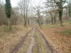
Turn right down a footpath that follows a track. Initially this heads eastwards; go through a gate and continue on as it enters trees and descends. Stay on this track, called Longcroft Road, for a couple of miles as it heads through Chase Woods. Eventually it meets a surfaced road by a house in a little hamlet called New Town. Join this road and follow it eastwards for a fifth of a mile until it reaches a road in Deanland.
Cross this road, and on the other side follow a track for a few yards eastwards uphill. When this track curves away to the right, go through a gateand continue on uphill. The path is easy to follow as it climbs; initially keep the hedge on the left. At the top of the hill it goes through a clapper-gate to enter Pribdean Wood. Continue along the path through the wood until it ends at a car park by a road. Turn left along this road, then after a few yards right, to start following another footpath eastwards.
Once more this climbs slightly, then joins a track that heads past a band of woodland, all the time heading in a more or less easterly direction, keeping a hedge on the left. When this meets a track turn left up the track. After a mile from the road West Woodyates Manor is reached; here turn half-left to starts heading northeastwards along a track. This climbs uphill, and after a little more than half a mile ends at a road in Cobley. Turn right down this road, and follow it for three-quarters of a mile southeastwards as it heads through Woodyates and ends at the A354 road once more.
Turn left along the road for a few yards past a bus shelter, then cross the road and take a bridleway that heads eastwards with a hedge on the right; on the other side of the hedge is a driveway. When this reaches a big green barn, turn right for a couple of yards, and then left to continue on eastwards along a track with a hedge on the right. This descends down a slight slope; pass a bridleway that comes in from the left, then leave the track and head straight on across a field until a little gate is reached that leads into Bokerley Ditch. Go through the gate and cross the bank and the ditch to reach the footpath on the other side.
Turn right to start following Bokerley Ditch southeastwards. This descends downhill, then starts climbing uphill once more After a mile a bench is reached; here turn right to cross a gap in the ditch along a rough track. After a few yards turn hard-right down another track; go through another gate, then after another few yards turn left through a clapper-gate to join another footpath. This climbs uphill along a narrow path westwards. As the gradient slackens at the top of the hill it opens out; follow a hedge on the right until a path comes in from the right, then turn half-left to cross a field southwards, joining the Jubilee Trail.
At the other end of the field turn half-right and start following the footpath southwestwards across Pentridge Hill. it goes through a gate; after this, continue on with a hedge on the left. After half a mile it enters a small band of trees called Penbury Knoll. Here I diverted off to the right to visit the trig pillar; otherwise continue on along the track. It leaves the band of trees, then curves to head southwards along the top of the hill with a hedge on the left. When the northern tip of Blackbush Plantation is reached, turn left and take another track that starts to head southeastwards.
After a mile a crossroads with another track is reached here turn right and follow a track that heads downhill between two hedges to the southwest. After two-thirds of a mile this ends at Cranborne Farm. Just before the farm is reached, turn left down a surfaced track. This heads southeastwards for 0.8 miles, with the River Crane a short distance away to the right. At Manor Farm the track curves away to the right; here continue straight on along a track, then turn left past the farm buildings, then right to continue on eastwards back towards Cranborne. It climbs uphill slightly as it does so, then slowly drops down into the village. Go through a gate and follow a track east to a road; then turn right and follow the road as it curves to the left, passing the 'Sheaf of Arrows' pub once more to head towards the car park where this walk started.
Distances
| From | To | Distance (m) | Ascent (ft) | Descent (ft) |
|---|---|---|---|---|
| Cranborne | Woodcutts | 7.7 | 538 | 374 |
| Woodcutts | Woodyates | 7.7 | 722 | 692 |
| Woodyates | Cranborne | 6.5 | 462 | 656 |
This makes a total distance of 21.9 miles, with 1722 feet of ascent and 1722 feet of descent.
For more information on profiles, ascents and descents, see this page
 |
 |
|
 |
 |
|
 |
 |
|
Disclaimer
Please note that I take no responsibility for anything that may happen when following these directions. If you intend to follow this route, then please use the relevant maps and check the route out before you go out. As always when walking, use common sense and you should be fine.
If you find any information on any of these routes that is inaccurate, or you wish to add anything, then please email me.
All images on this site are © of the author. Any reproduction, retransmissions, or republication of all or part of any document found on this site is expressly prohibited, unless the author has explicitly granted its prior written consent to so reproduce, retransmit, or republish the material. All other rights reserved.
Although this site includes links providing convenient direct access to other Internet sites, I do not endorse, approve, certify or make warranties or representations as to the accuracy of the information on these sites.
And finally, enjoy your walking!
Nearby walks
| # | Title | Walk length (miles) |
|---|---|---|
| 790 | A circular walk from Salisbury | 24.0 |
| 799 | A circular walk from Broad Chalke to Win Green Hill | 23.0 |
| 800 | A circular walk from Hindon to Ludwell | 20.6 |
|
|

|