Walk #790: A circular walk from Salisbury
 |
 |
|
General Data
| Date Walked | 22/10/2007 |
| County | Wiltshire |
| Start Location | Salisbury station |
| End Location | Salisbury station |
| Start time | 09.00 |
| End time | 17.34 |
| Distance | 24.0 miles |
| Description | This was a long circular walk across the ranges of hills to the west of Salisbury. |
| Pack | Today I carried my 30-litre Karrimor rucksack, filled with waterproofs, a book and other odds and ends. |
| Condition | I feel absolutely fine after this walk, and have no problems to report. |
| Weather | The day was dominated by high, hazy cloud that pretty much spoiled any views that there may have been. It was a slightly chilly day, but there was no sign of any rain or, for that matter, wind. |
| OS map | Landranger number 184 (Salisbury & The Plain, Amesbury) |
 |
 |
|
 |
 |
|
Map of the walk
Maps courtesy of Google Maps. Route for indicative purposes only, and may have been plotted after the walk. Please let me have comments on what you think of this new format. For a detailed table of timings for this walk, please see the table file.
 |
 |
|
 |
 |
|
Notes
Now that I have moved down from Cambridge to Romsey, I want to spend some time exploring the new walking opportunities that have opened up for me. Up to today I had connected the western end of the South Downs Way at Winchester up with Romsey, and walked from Romsey along some of the Test Valley Way and up to Salisbury. This has opened up the area around Salisbury Plain to me for walking, and on the map there seemed to be an obvious - if long - walk to be done to the west of the town.
It took me longer than I expected to get to Salisbury due to the morning traffic, and eventually I set off from the Central car park (which cost me five pounds to park for the day!) to get to the station, where I had ended the last walk. On the way I nipped into a little newsagents to buy some chocolate for the day, and was surprised by the frankly sexist comments that one of the ladies serving was making about her (apparently new) boyfriend. If a man had been making similar comments about women he would have been well out of order, but the comments just amused me.
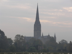
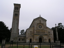
Once at the station I quickly reset my GPS and started the walk, heading along the road for a few hundred yards before turning off to cross the River Nadder on the Long Bridge. This was a fairly picturesque spot, and on the other side of the bridge the path continued along a little causeway, with floodplain on the right and a stream on the left. The ridges on the ground to the right reminded me of medieval field systems, but a signboard told me that the ground is maintained with the ridges and furrows to keep it as water meadows. In the distance to the left there were views of Salisbury Cathedral, a classic view over the water meadows that was slightly spoilt by the hazy skies.
This entire stretch was pleasant, and as the path crossed another little bridge to meet the picturesque Old Mill, with stonework made of alternating sections of stone and flints, giving the walls a chequerboard appearance. Once past the mill the view back towards it was pleasant, but once across the A3094 road I started up a track that headed towards Harnham Hill. I could not find the path that I had marked on the map up the slope, so took a more gradual one that climbed through the trees before reaching the end of houses, and then followed a road that was leading towards a large mast on the hillside. The closeness of the mast told me that I was slightly away from where I had intended to be, but a short diversion down a road took me to the start of Old Shaftsbury Drove.
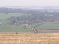
Initially this was narrow as it ran between hedges along the top of Harnham Hill, but soon it became a wide, surfaced track that passed a house before rising up to reach a farm at the top of a hill. What should have been good views were somewhat spoilt by the hazy skies, and at the farm the surfacing ended and an unsurfaced track continued on. Before I knew it I could see white railings to the right, marking the edge of Salisbury racecourse, which I had not noticed when I had studied the map. Occasionally there were removable piences of the railings marked 'ambulance access', and it was obvious that emergency vehicles could use the stretch of track that I was walking along.
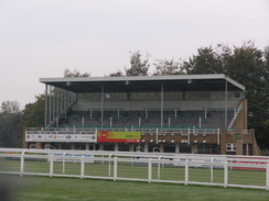
After a while the track diverted slightly away from the racecourse and entered an small area of woodland, at which the track became much boggier underfoot and consequently harder to walk along. It was therefore a relief when the track emerged onto a surfaced road by some racecourse grandstands and a caravan site, which allowed me to motor along. I have never been to a horse race before and must admit that I am fairly intrigued about what it must be like, although as I am not a betting man must of the attraction is not there. One of the grandstand was made of concrete and looked fairly old, but others seemed much newer, and it was interesting to see the various buildings and their purposes.
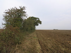
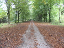
The racecourse complex ended at a road, and a good track continued on through trees westwards. It was not the most interesting walk and the trees obstructed most of what I had been expecting to be good views from the ridge, and after a while I decided to divert off the track to attempt to find a trig pillar that was marked on the map in a nearby field. It proved easy to follow a hedge northwards along the field boundary but I could not find the pillar, which looked as though it would be in the middle of a thick hedge. Once the northern edge of the field was reached next to a piggery I turned back and tried to look along the other side of the hedge, where I suddenly found the pillar embedded in the hedge.
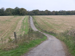
It was not possible for me to see the number on the flush bracket so after taking a few photos I headed back along the hedge to the rack, and continued walking westwards along it. There was a couple walking ahead of me and I soon overtook them as I tried to get a move on, as there was still a long way for me to go today. The lack of views was a disappointment, and I was glad when Compton Down was reached, and the point where I would divert off the ridge and head downwards. Down below me there was a track snaking towards a farm, and a quick glance at the map showed that this would be what I was following, but the hillside was very steep. Instead of heading directly down I took a faint path that angled down, and an overgrown stile at the bottom showed that this was probably an official route.
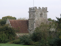
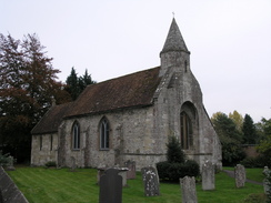
I had to follow the track downwards for a few yards to get back to the point where it headed off towards the farm, but I was soon striding down a tree-lined surfaced track, with the hills slowly receding behind me. After passing through Manor Farm a main road was reached, and I had to carefully cross this before continuing northwards along a road into the pleasantly-named village of Compton Chamberlyne. The church as just off the route and I settled for getting a few photographs of it from the road, before continuing on along a footpath that passed a pretty mill that has been converted into a house. Just past this there was a crossing over a railway line, but immediately before this there was a man herding cows to the crossing. There were cows crowding the area across from me and I settled down to wait for the man to finish herding the cows, but he kindly kept them away from me and allowed me to pass.
I reached a main road by a lovely little thatched bus shelter, and diverted off the route to the nearby pub. Initially this appeared to be closed, but closer inspection showed that it was open and I went in for a drink. It was nice to get the weight off my feet and I drunk a couple of pints whilst I read a pamphlet on local walks, which also contained little nuggets on the history of the area. It was a fascinating read, and it would be nice if all areas could have similar information available about them.
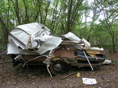
After leaving the pub I returned to the bus shelter and started following a road that passed some nice houses before turning and starting ti climb. Before the climb was over a track led off to the right, leading me slowly downhill to reach a farm, after which a footpath led me up towards some woodland. The day was still fairly hazy and this was spoiling what little views there were, and these disappeared as the path disappeared to meet the Monarch's Way in some woodland. This was on a broad, rough track, and soon I came across the remains of a ruined caravan, the front of which had been destroyed as if crushed by a great weight.
In places further along the track there were little pieces of caravan, wood and aluminium that I guess had been torn off by the branches of low-hanging trees overhead. Whatever the cause, it was a terrible example of presumed fly-tipping that will cost someone money to tidy up. The track ended at a road that was followed for a short distance to the most northerly point of the day's walk, before turning off along a track along the northern edge of some woodland. As I walked along this rough track I was nearly bowled over by a car coming from behind - I was not expecting any vehicles on such rough ground, yet alone an estate car!
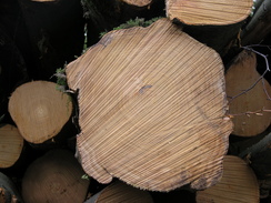
I could not find the track I had planned to take on the map so I continued on along the track around the outside of the woods, but at a building that was not marked on the map there was a good track, so I followed that into the woods. A short distance later there was a gate and on the other side of this were many cut logs, and the smell of sap hung heavy in the air. A little further on there was a lorry trailer being loaded with cut logs, but once past this it became a routine and boring walk along the forestry track. I zoned out and listened to an interview with Michael Winner on Radio Five that helped pass the time, and a chat with a man at a gate who used to be stationed with the RAF at Waterbeach - where I used to live - also livened up the otherwise routine plod.
Once out of the woods a path took me on downhill into the little village of Wilton, and I took a winding route through the village, passing a ruined church and along a road that crossed several streams. It was starting to get late, and so I plodded on, soon joining the A30 by a pretty little church. The road was busy with afternoon traffic and the fumes and noise were not nice, so at the first opportunity I left the main road and headed down into Quidhampton. A footpath took me behind houses before dropping me off at a road that headed eastwards, and just at the point where it started to get busy a concessionary path took me off the road - a really nice gesture by the local estate.
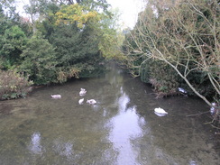
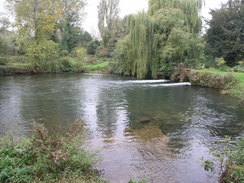
The path ended at a farm and I had to rejoin the road for a short distance before another path headed down the bank of the River Nadder, giving me a good view of a pleasant stretch of the water. The church in the village was pretty, but soon I was out of the village and the road entered the western outskirts of Salisbury. Initially this passed a series of undistinguished industrial buildings with a railway line on the left, and these continued almost up to the point where the station car park was reached. As soon as I got there I headed through the car park to reach the front of the station, and then walked on back to my car.
As sometimes happens, what had promised to be a good walk on the map had been let down by a combination of weather and woods, the latter blocking many views out and the former spoiling those that remained. Having said that I enjoyed the walk, and it has set me up well to do others to the north and south of this walk.
 |
 |
|
 |
 |
|
Directions
This walk starts off from Salisbury railway station. Walk dow the station approach, and then turn right along Mill Lane. This crosses a mini-roundabout and then curves to the left. Shortly after his curve turn right to join a footpath that crosses a tributary of the River Nadder on a footbridge called Long Bridge. After this a long causeway crosses the floodplain. This crosses the main part of the river, then passes the Old Mill before ending at a T-junction with a road opposite Harnham church.
Turn left to follow this road southwards until it ends at the A3094 road. Cross the road, and on the other side take a footpath that heads southwards. This crosses a minor road before continuing on up a track before reaching a track at the base of Harnham Slope. Turn half-left to follow a footpath that heads steeply up the hillside through trees; when this meets another track continue straight on along a small road that ends at a local road by a mast on Harnham Hill (SU135284).
Turn right along this road, and after a hundred yards turn right to join a track. This heads slightly south of west for two and a half miles, passing a house at Braemar and then Salisbury racecourse before reaching a road near Cowper's Cross. Cross this road and head westwards along the track for a little under 4.5 miles, until a junction with another track is reached by a reservoir at SU033279.
Here turn right and descend northwards downhill along a footpath; it is very steep, and the path on the ground does not head as directly down as shown on the map. The footpath ends at a track at the base of the hill, and this track can be followed northwards for about three quarters of a mile as it passes Manor Farm before ending at the A30 road. Cross the A30 and continue on along another road northwards through Compton Chamberlyne; the road passes near to the church and continues on northwards.
At a sharp right-hand bend at SU027306 leave the road and head straight on along a footpath; this reaches a bridge at Dinton Mill. Here turn left, to follow a track northwestwards. This crosses a railway line before reaching the B3089 road in Dinton. Cross the road, and on the other side follow a road that heads northwards. This curves to take a more westerly course, then at SU016319 turn right along a track. When this forks take the right-hand fork, which leads past a house. Continue on northwards along a footpath that climbs uphill, passing a reservoir before starting to descend. About a mile after the house the footpath enters a small band of trees and ends at a track that carries the Monarch's Way. Turn left to follow the track and Monarch's Way as it heads northwestwarsd through patchy woodland for about a mile before it ends at a road.
Turn right to head northwards along this road for a couple of hundred yards through Dinton Beeches, then turn right to head eastwards along another road. After a short distance this ends; when it does, continue on with the trees on the right. At a building turn right to head eastwards along a track through some woodland. A little more than two miles later the track reaches a junction with a track near Grovely Wood; head straight on along another track that skirts the souther edge of some woodland. After 2.5 miles this descends down Grovely Hill to meet other tracks near Ugford Red Buildings. Here turn left and start following the track that curves to head southeastwards towards Ditchampton. When the end of a road is reached turn left to take a bridleway that heads behind gardens to end at a road junction in Ditchampton.
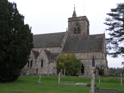
Turn right along a road that immediately plunges under a railway bridge, and shortly afterwards it reaches the A30 road in Wilton. Turn right to head southeastwards, passing the church on the right, then turn left up another road that heads northeastwards for a third of a mile before ending at the A36(T). Turn right along the A36(T) and follow it eastwards for a short distance to a roundabout with the A30 near the church at Fugglestone St Peter. Cross the roundabout, and continue on eastwards for 0.4 miles, then turn right down the A3094.
Head south along the A3094 for a short distance towards Quidhampton, then turn left to start following a footpath that runs eastwards behind some houses. This footpath ends at a road; follow this road eastwards for a few hundred yards, then turn right down another road for two thirds of a mile. It passes Bemerton church. At a road junction turn right to continue heading straight on eastwards for about a mile through the western outskirts of Salisbury, passing an industrial estate on the right. The station car park, then the station itself, is soon reached on the left.
Distances
| From | To | Distance (m) | Ascent (ft) | Descent (ft) |
|---|---|---|---|---|
| Salisbury station | Dinton | 11.4 | 728 | 640 |
| Dinton | Salisbury station | 12.6 | 801 | 889 |
This makes a total distance of 24.0 miles, with 1529 feet of ascent and 1529 feet of descent.
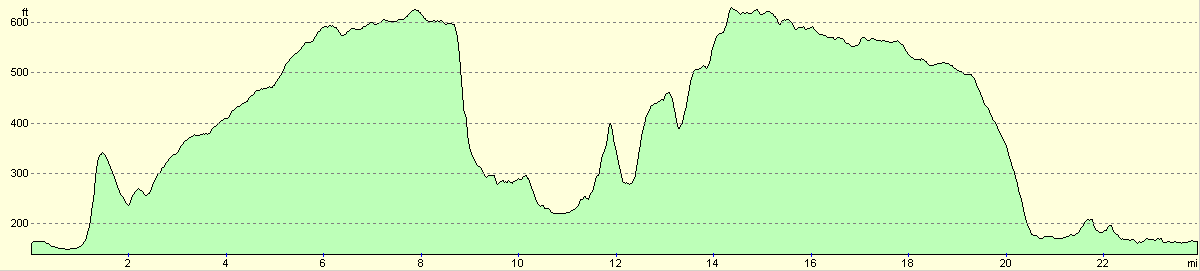
For more information on profiles, ascents and descents, see this page
 |
Disclaimer
Please note that I take no responsibility for anything that may happen when following these directions. If you intend to follow this route, then please use the relevant maps and check the route out before you go out. As always when walking, use common sense and you should be fine.
If you find any information on any of these routes that is inaccurate, or you wish to add anything, then please email me.
All images on this site are © of the author. Any reproduction, retransmissions, or republication of all or part of any document found on this site is expressly prohibited, unless the author has explicitly granted its prior written consent to so reproduce, retransmit, or republish the material. All other rights reserved.
Although this site includes links providing convenient direct access to other Internet sites, I do not endorse, approve, certify or make warranties or representations as to the accuracy of the information on these sites.
And finally, enjoy your walking!
Nearby walks
| # | Title | Walk length (miles) |
|---|---|---|
| 629 | Shrewton to Warminster | 16.7 |
| 788 | Romsey to Salisbury | 23.1 |
| 796 | Romsey to Salisbury via Dean Hill | 23.6 |
|
|

|