Walk #438: Allonby to Angerton
 |
 |
|
General Data
| Date Walked | 10/05/2003 |
| County | Cumbria |
| Start Location | Allonby |
| End Location | Angerton |
| Start time | 08.05 |
| End time | 17.58 |
| Distance | 24.1 miles |
| Description | This was quite a long day, but an enjoyable one nonetheless, with much to be seen, even on the long road sections towards the end of the walk. |
| Pack | Today I carried my 30-litre Karrimor HotRock rucksack, which was filled with my packed lunch, waterproof leggings, water bottle and a couple of spare shirts, together with the usual assortment of odds and ends. |
| Condition | I feel absolutely fine after this walk, and I could easily have walked further if I had needed to (and indeed I was tempted to). Both of my ankles are fine, and my feet have not suffered from the long road sections. |
| Weather | The forecast was for sunshine and showers, although thankfully we had plenty of the former and none of the latter. For much of the day there was very little cloud, and the day was only let down by the wind, which was quite cold and strong at times. |
| OS map | Landranger number 85 (Carlisle & Solway Firth, Gretna Green) |
 |
 |
|
 |
 |
|
Map of the walk
Maps courtesy of Google Maps. Route for indicative purposes only, and may have been plotted after the walk. Please let me have comments on what you think of this new format. For a detailed table of timings for this walk, please see the table file.
 |
Notes
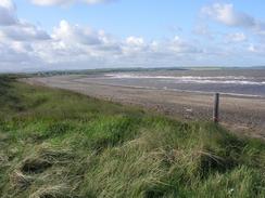
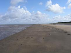
I woke up feeling quite good, and I was ready to do a long stroll. The majority of the first stretch of the walk was along a beach, This was quite enjoyable, and there was plenty to see out to sea, such as the summit of Criffell standing proudly across the water in Scotland. The time and the miles just flew by, and I soon found myself diverting inland past a golf course and the harbour to reach the centre of Silloth.
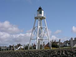
Sam was waiting for me by the lifeboat station at Silloth, which is near the docks in the town and the tall buildings of the flour mill. I joined Sam in Mervan for a chat and to eat my lunch, as I was aware that the next leg of the day was going to be quite long. I spent longer stopped than I had been intending, but I was not bothered, as I had set of earlier than I normally do. The seafront area of the town was quite nice, and I enjoyed the walk along the seawall past the short and squat lighthouse.
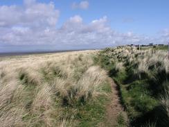
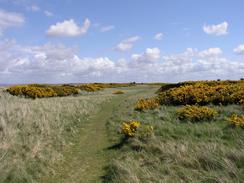
I decided to walk around the little peninsular of Grune Point, which to a certain extent was pointless as I ended up in Skinburness, which was only a short distance from the coast on the other side of the peninsular. Since it only added a couple of miles onto my route I was not that bothered, and I got some good views over to Scotland and the NATO radio station at Anthorn.
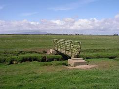
From Skinburnness the footpath on the map crossed a large area of marshland. This was easy to follow in places, as there were regular low posts to mark the way, but in others it was much harder as these were absent as I had to make my own way across the marshes. Looking at my Ordnance Survey map it is obvious that the pots take you slightly further north across the marshes from where it is marked on the map - locals would probably know the best (and definitive) route. The going was reasonably good early on, but later towards the end it got boggier and harder going, and I came out with the bottom of my trousers quite muddy. As I joined another footpath that ran along the side of the River Waver into Abbey Town I got a phone call from Terry, and we chatted for a while as I walked along.
I finally got to Abbeytown and found Sam and my parents waiting for me in Mervan outside the pub. We chatted for a few minutes, and we were about to go into the pub when a man came out of a house by which Mervan was parked and asked us to move. He was relatively polite, and so Sam moved Mervan into the pub car park. We had a good chat, and the rest allowed me to recharge my batteries ready for the next stretch of walk. I used the opportunity to change into my trainers, as the rest of the walk was going to be along roads.
The church in Newton Arlosh is quite nice, being made out of a lovely red sandstone. It is quite a small church but is massively constructed, and it looks very much as though it is a fortified church, which is not surprising considering that this area is so near the Scottish border, and I can imagine that the Reivers got this far. I also saw what looked like a fortified barn later on in the walk, which must therefore have been quite an old barn.
I was absolutely shattered tonight, which is hardly surprising after such a long walk. We went into the pub in Newton Arlosh later on this evening and we chatted to the owners for quite a long time. It was very nice of them to allow us to stay in their car park, and the pub itself is very nice. Having a late night after today's walk is probably not a good idea, and it will be interesting to see what state I will be in when I wake up in the morning. Tomorrow is going to be a long road walk, so it should not be too strenuous and so I am not too worried about being tired.
Directions
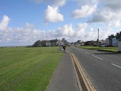
This walk starts at a car park in the little village of Allonby, just across the road from a pub. Almost the entire walk (except for a short stretch at the end) follows the Cumbria Coastal Way, although at times I followed the beach rather than the footpaths. Head north along the B5300 past the bridge over Crookhurst Beck in the village, and on until a car park is reached on the left. From here a footpath runs along to the right, heading northwards between the sea and the road. The gap between the sea and the road becomes narrower and narrower, until I chose to walk along the road at Oldkiln. When I reached Dubmill Point the road heads off inland to the right, and I joined the beach and walked northwards along that.
Continue northwards along the beach for a few miles until you are level with the Lees Scar Lighthouse out to sea, and then turn right to follow a track through the dunes past a golf course that ends at a large building. Join the driveway and follow this northwards and then when it meets the edge of a dock turn to the right and follow a road around the edge of the dock. When this road meets the B5300 road in the town turn left to head past the flour mill towards the lifeboat station. At the lifeboat station turn to the right and follow a seawall northeastwards for nearly two miles into Skinburnessbank, from where a footpath heads on, initially along a track, through Grune until Grune Point is reached.
From Grune Point turn to the right to head southwestwards along the foreshore for a mile until it reaches a road in Skinburness. At the point where the road is met a footpath leads over the flood bank and down to a bridge by the side of the Skinburness Marsh, from where a series of small stakes shows the lines of the path through the marshes. This path initially head southeastwards before turning to head eastwards and then curving around once more to head southeastwards past Border. From here I found that the path got muddier and boggier, and as the path headed south past Brownrigg it took me longer to walk. The path ends at a road; turn left down this road for a short distance before taking a footpath off to the left, which follows the southern bank of the River Waver before heading away from the river to the southeast. The footpath joins a track, which dives under an old railway bridge before ending at the B5307 road. If you want to visit Abbeytown then turn to the right and follow a road past the remains of Applegarth Abbey until you reach the pub in the village.
Turn around and head eastwards out of the village along the B5307 road, passing the remains of Applegarth Abbey and heading southeastwards out of the village until a road junction at Raby is reached. Follow the road as it curves to the left to head towards Raby Grange. When the road curves sharply to the right continue straight on along another road. This curves around to pass Salt Coates before meeting the B5307 road once more. Join the B5307 and follow it northeastwards through the village of Newton Arlosh. At the eastern end of the village the Cumbria Coastal Way heads down a road eastwards; ignore this turning and continue on for another couple of miles until the road enters Angerton. When the road curves around to the right in the village turn to the left; a few yards along on the right is the Kirkbride bowls and tennis club, where this walk ends.
For more details of the Cumbria Coastal Way, see the excellent little book, The Cumbria Coastal Way: A Walker's Guide", by Ian and Krysia Brodie, ISBN 187355110X. This book is a lovely and detailed description of the walk, and unfortunately I did not manage to get a copy until after I finished the walk, for it would have been quite handy.
Distances
| From | To | Distance (m) | Ascent (ft) | Descent (ft) |
|---|---|---|---|---|
| Allonby | Silloth | 7.4 | 233 | 226 |
| Silloth | Abbeytown | 10.4 | 233 | 207 |
| Abbeytown | Angerton | 6.3 | 144 | 164 |
This makes a total distance of 24.1 miles, with 610 feet of ascent and 597 feet of descent.
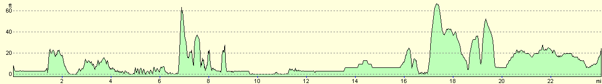
For more information on profiles, ascents and descents, see this page
Accommodation
We parked Mervan in the car park of the Joiners Arms Country Inn in Newton Arlosh. This as a nice pub with a friendly atmosphere, and the landlord was kind enough to let us stay in the car park for the night.
Disclaimer
Please note that I take no responsibility for anything that may happen when following these directions. If you intend to follow this route, then please use the relevant maps and check the route out before you go out. As always when walking, use common sense and you should be fine.
If you find any information on any of these routes that is inaccurate, or you wish to add anything, then please email me.
All images on this site are © of the author. Any reproduction, retransmissions, or republication of all or part of any document found on this site is expressly prohibited, unless the author has explicitly granted its prior written consent to so reproduce, retransmit, or republish the material. All other rights reserved.
Although this site includes links providing convenient direct access to other Internet sites, I do not endorse, approve, certify or make warranties or representations as to the accuracy of the information on these sites.
And finally, enjoy your walking!
This walk was mentioned in the following routes:
| My walk around the coastline of Britain |
Nearby walks
| # | Title | Walk length (miles) |
|---|---|---|
| 437 | Parton to Allonby | 20.2 |
| 439 | Angerton to Burgh by Sands | 17.3 |
| 442 | Gretna to Powfoot | 17.9 |
|
|

|