Walk #838: A circular walk from Rhossili
 |
 |
|
General Data
| Date Walked | 13/06/2009 |
| County | West Glamorgan |
| Start Location | Rhossili |
| End Location | Rhossili |
| Start time | 10.14 |
| End time | 15.55 |
| Distance | 10.7 miles |
| Description | This was a pleasant walk, taking in Worm's Head, Rhossili beach, and the high ground of Rhossili Downs. |
| Pack | Today I carried my 30-litre Karrimor rucksack, filled with waterproofs, a fleece,a book and other odds and ends. |
| Condition | I feel absolutely fine after this walk. |
| Weather | Today was gloriously sunny and fairly warm. |
| OS map | Landranger number 159 (Swansea & Gower, Carmarthen) |
 |
 |
|
 |
 |
|
Map of the walk
Maps courtesy of Google Maps. Route for indicative purposes only, and may have been plotted after the walk. Please let me have comments on what you think of this new format. For a detailed table of timings for this walk, please see the table file.
 |
 |
|
 |
 |
|
Notes
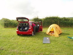
A few months ago I had arranged to go on a short weekend walking trip with Jacqui, an old friend and work colleague of mine. After looking at going to Pembrokeshire, we decided to go to the Gower instead, as it was less of a journey for both of us. It was an interesting choice for me; I had only ever been there on the coastwalk, and it was the only time on the entire trip that I had felt like giving up. I had expected the scenery to be great, but bad weather had meant that it was an extreme disappointment. Now we were heading back, and until the Thursday the forecast was for heavy rain. Sencan and I drove up to the campsite I had booked at Kennoxstone Farm on Friday afternoon; Jacqui arrived a while later after a long journey. The campsite is very nice, with good, clean facilities. Fortunately the weather was bright and clear, although there was a short shower just after we had erected our tiny tent.
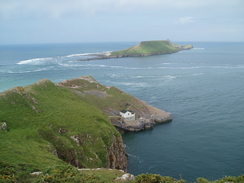
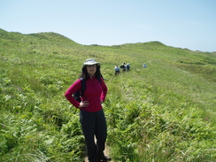
This was Sencan's first camping trip, and it was therefore a relief that she had a good night's sleep. We then got all our kit together and jumped into our car for the drive to Rhossili. The car park in the village was not too busy when we arrive, and we were soon ready for the walk. Fortunately, my fears of rain were unfulfilled, and it was a gloriously sunny day. Although our plan as to walk along Rhossili beach, we decided to go and have a look at Worm's Head first. Instead of following the motorway-like path down from the car park, we headed back into the village and then took a footpath along to the headland. The first path we tried was a little too overgrown, so we doubled back and took another path.
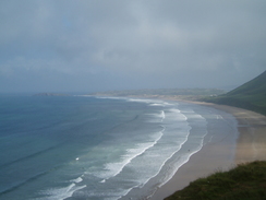
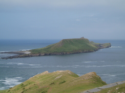
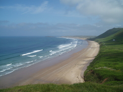
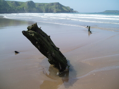
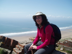
The views over towards Worm's Head were superb, and it was good to see it in fine weather after the dreary weather on my previous trip. There were lots of people around, and soon we were heading back up towards the village and down the steps that led onto the southern edge of the beach. Soon we came across a few wooden spars sticking out of the sand, the wreck of the Helevetia, the sad remains of a once-proud ship. It is interesting to compare what we saw with other photos of the wreck - the level of the sand obviously varies considerably.
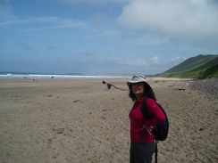
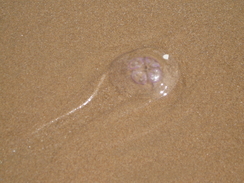
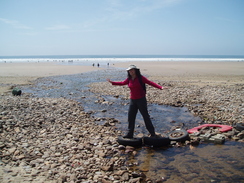
A little further on we came across the first of what were many dead common jellyfish on the beach. They are very strange looking creatures - circular and transparent except for four rectangles which are, apparently, their gonads. As we walked on the beach became increasingly less busy, as people had further to walk from the entrance to the beach. Then it became busier once more as we neared the stream of Diles Lake, and another entrance onto the beach.
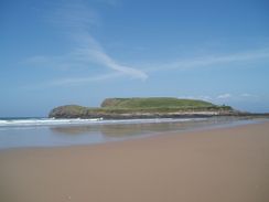
We soon reached the end of the beach at Spaniard Rocks, and we walked across the slippery rocks to try and reach the headland of Burry Holms. Unfortunately the tide was too high, and the channel between the rocks and the headland was flooded. I could remember exploring the ruins on the headland on my previous trip, but there was no getting across it today. Instead, we climbed up above the rocks and sat down to have lunch. As we ate, the tide receded, until eventually a man waded across to the island.
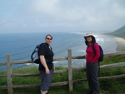
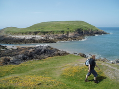
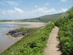
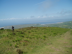
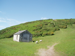
After lunch, we headed up over the sand dunes along a path that skirted the edge of the cliffs, giving us superb views over the bays to the north. At one point a natural arch was visible, and there were lots of pretty butterflies around on the vegetation. Frankly, I loved the walk. It then descended down to end at a caravan park, and a series of tracks and paths took us back towards the beach. Compared to what we had just experienced, this was a boring and uninteresting stretch. We had to walk back onto the beach to cross the stream called Diles Lake, which had hundreds of tadpoles in, and we then haded back inland into another massive caravan park. This had a caf� in it, and we stopped off to get a couple of ice creams and three bottles of water. Jacqui did not have an ice cream, and this proved to be wise.
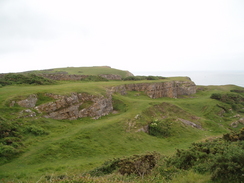
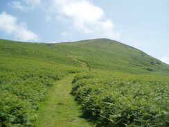
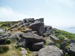
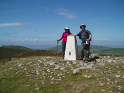
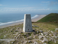
What followed was a steep climb up onto Rhossili Downs. This was a bit of a puff, and both Sencan and I felt a little sick after the lovely ice creams. We soon reached the first summit, and we climbed up to some old brick and concrete ruins to admire the view to seaward. It was a beautiful spot. Off to our right was a large area of concrete ruins, the remains of a Second World War 'Chain Home Low Station' - a radar complex. Another climb then followed, thankfully gentler this time, up to the trig pillar on The Beacon, the highest point of Rhossili Downs and the entire Gower peninsular. Again, the views were superb.
The descent down to Rhossili was steep, although not too steep for a couple to be cycling up. In the village we stopped off for another ice cream, before heading back to the car. It had been a fulfilling and beautiful walk, if a little short. After we got back to the car we drove along the coast to Oxwich, to have a stroll along the beach there and watch all the pleasure boats be hauled up the beach by tractors.
 |
 |
|
 |
 |
|
Directions
This walk starts off at the car park in Rhossili. Leave the car park and turn right to follow the B2427 eastwards. Just past the church, turn right along a footpath. This heads southwards for a few yards, and then turn right along another track that heads westwards past fields. At SS411877 turn left along another track, and then after a couple of hundred yards right along another path that heads west-southwestwards for a few hundred yards until it ends at the top of the cliffs. Turn right and follow a path that runs along the top of the cliffs until above Kitchen Corner.
Here turn right and follow a good path that heads northeastwards along the top of the cliffs. Pass the car park and visitor centre, and then turn left along a footpath. This descends down steps to reach the southern end of Rhossili beach. Turn right and follow the breach northwards for two and a half miles until Spaniard TRocks are reached by Burry Holms. Turn right and follow a footpath that heads eastwards along the edge of the cliffs, climbing steeply before settling on a more level course. The path starts descending, and follows a boardwalk before ending at a road in a caravan park.
Turn right and follow this road southwards. Just after a car park on the right, a footpath leads off to the right. Follow this path as it heads south-southwestwards, squeezing between Moors Hill on the right and Llangennith Moors on the left. This eventually meets a stream on the left, and follow this back out onto the beach. At the first opportunity cross the stream, and then follow the southern bank of the stream until a track is reached.
Follow this track southeastwards through a caravan park; it turns to the left to head eastwards. Pass a caf� and head for the exit of the caravan park. Exit the park, and then turn right along another footpath. This climbs rapidly to the south. Once at the top the gradient levels off, before descending down towards the concrete cases of the old radar station. It then climbs once more, eventually reaching the trig pillar on the Beacon, the highest point on the entire Gower.
Continue on the path to the south, following it as it starts to descend from the hill. This eventually ends at the B4247 road in Rhossili; turn right and follow the road as it passes the church and heads back to the car park, where this walk ends.
 |
 |
|
 |
 |
|
Distances
| From | To | Distance (m) | Ascent (ft) | Descent (ft) |
|---|---|---|---|---|
| Rhossili car park | Spaniard Rocks | 5.6 | 600 | 840 |
| Spaniard Rocks | Rhossili car park | 5.1 | 1237 | 997 |
This makes a total distance of 10.7 miles, with 1837 feet of ascent and 1837 feet of descent.
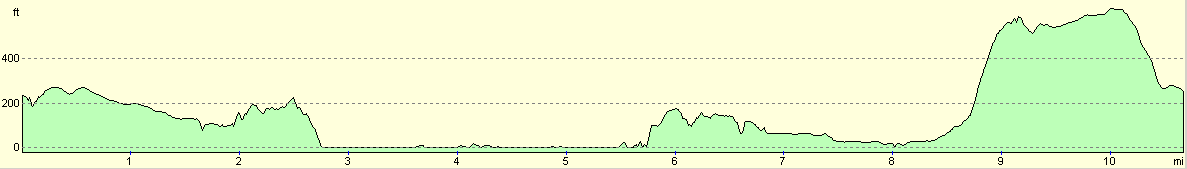
For more information on profiles, ascents and descents, see this page
 |
 |
|
 |
 |
|
 |
Disclaimer
Please note that I take no responsibility for anything that may happen when following these directions. If you intend to follow this route, then please use the relevant maps and check the route out before you go out. As always when walking, use common sense and you should be fine.
If you find any information on any of these routes that is inaccurate, or you wish to add anything, then please email me.
All images on this site are © of the author. Any reproduction, retransmissions, or republication of all or part of any document found on this site is expressly prohibited, unless the author has explicitly granted its prior written consent to so reproduce, retransmit, or republish the material. All other rights reserved.
Although this site includes links providing convenient direct access to other Internet sites, I do not endorse, approve, certify or make warranties or representations as to the accuracy of the information on these sites.
And finally, enjoy your walking!
Nearby walks
| # | Title | Walk length (miles) |
|---|---|---|
| 377 | Caswell to Port Eynon | 11.3 |
| 378 | Port Eynon to Landimore | 18.6 |
| 379 | Landimore to Pwll | 19.7 |
|
|

|