Walk #839: A circular walk from Oxwich over Cefn Bryn
 |
 |
|
General Data
| Date Walked | 14/06/2009 |
| County | West Glamorgan |
| Start Location | Oxwich |
| End Location | Oxwich |
| Start time | 10.25 |
| End time | 15.06 |
| Distance | 8.3 miles |
| Description | This was a very pleasant walk, taking in beach, dunes and a superb ridge walk with views over both coasts of the Gower. |
| Pack | Today I carried my 30-litre Karrimor rucksack, filled with waterproofs, a fleece,a book and other odds and ends. |
| Condition | My left ankle lost a great deal of it's rotational strength in the last couple of miles of the day, meaning that it was rotating more than it should have. Otherwise everything was fine. |
| Weather | Today was a lovely day; warm, sunny and generally a good day for a walk. |
| OS map | Landranger number 159 (Swansea & Gower, Carmarthen) |
 |
 |
|
 |
 |
|
Map of the walk
Maps courtesy of Google Maps. Route for indicative purposes only, and may have been plotted after the walk. Please let me have comments on what you think of this new format. For a detailed table of timings for this walk, please see the table file.
 |
 |
|
 |
 |
|
Notes
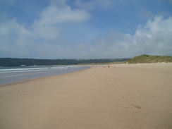
After yesterday's walk we fancied doing another coastal stroll (although, to be frank, it is hard to devise a walk of any length that is not coastal on the Gower). In the end we decided to do one from Oxwich, heading along the beach and then back along the ridge of Cefn Bryn. Therefore we packed up our tents and set off for the short drive from the campsite to Oxwich. After a little It did not take us long to get out gear together, and then the three of us set off along the beach. It was a beautiful morning, and there were a few other people strolling along with us. We soon reached Nicholaston Pill, a stream which we had to cross. On the map there is abridge further inland, but the state of the tide allowed us to cross it with no problems. A short distance further east we reached Little Tor. The tide was relatively high, although we could have squeezed past. Hpwever, Great Tor behind was impassable. There was a path marked on the map between the two Tors, but we could not see this from the ground, so we opted to head up the path that climbed up to the top of Little tor.
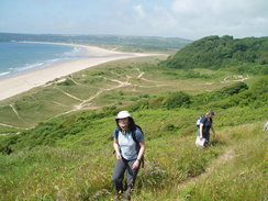
This proved to be quite a climb; initially on the edge of the sand dunes of Nicholaston Burrows and then up a steep, sandy path onto the top of the Tor. The sand was slippery, and it was a literal case of one step forwards, half a step backwards. The view from the top were worth it, however; grand views back over the beach to the west, and views of great Tor to the east.
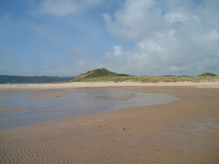
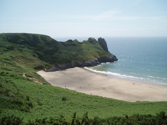
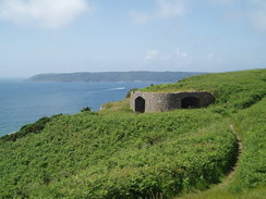
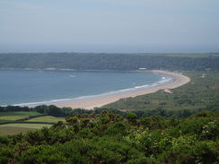
A path took us above Little Tor and then onwards towards Penmaen Burrows. Here we passed some restored limekilns, before reaching a path that headed down to the beach between the two Tors; we headed straight on here across the burrows, looking for the burial chamber marked on the map. Unfortunately we didn't see this, and there was little point in scrambling around the sand dunes in a search for it. The diversion was not wasted, however, as the view at the other end over Threecliff Bay was superb. I recalled when I was last here, on my coastal walk, on a wet, awful day that made me want to end the entire walk. It felt almost cathartic to be back there on a beautiful, sunny day.
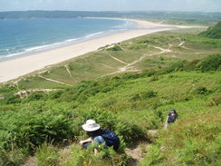
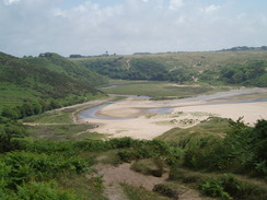
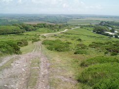
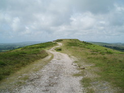
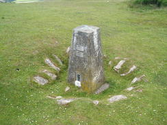
Next, a path took us uphill towards the A4118 road in Penmaen, after which a small, narrow lane took us to the start of the path that led up onto Cefn Bryn. This was a great climb, and the views that unfolded in all directions made the climb well worthwhile. Near the top we could see both the south coast of the Gower and the north coast, with the coast of Llanelli behind. It was absolutely superb. At the top of the hill there was a buried water reservoir; slightly behind this there was a trig pillar that had been inset into the ground. We paused to take some photos, then headed downhill for a short distance before stopping for lunch, with views over Oxwivch Burrows in front of us.
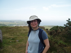
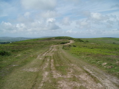
The next stretch of walk along the ridge of Cefn Bryn was an absolutely superb walk, with good views in all directions. Frankly, I loved it, and Jacqui and Sencan also seemed to enjoy the stroll. We could have continued on further along the ridge towards its end at Reynoldston, but we all had long journeys ahead of us. Instead, we struck down a path that descended down and through Hayes Wood; on the way we saw dragonflies.
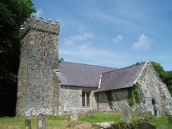
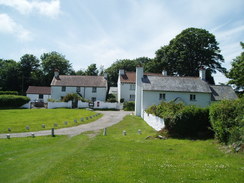
At Home Farm beside the A4118 we could see a two-storey building raised up on stone mushrooms; these are used to keep geanries away from the damp ground, and prevent rats and mice from gaining access. However, if it was a granary then it was the grandest granary that I have ever seen. Off to the left was the entrance into Penrice Castle, part of which could just be viewed from the road. The road was narrow as it descended steeply downhill, bottoming out by a stream and small car park before ascending steeply once again. A short distance along we took a footpath that deposited us by the pretty little Penrice church.
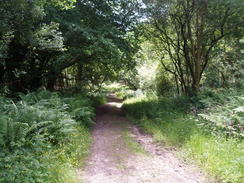
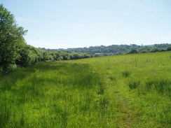
A footpath took us back downhill, alternating across fields and through woodland. It was easy to follow, although slightly muddy in places (the only mud that we had seen on the entire trip). Once the path levelled out it entered a field that took us back towards Oxwich. Here I started to have a few problems with my left ankle; I have not done any walking for a couple of months, and that ankle has been operated on several times. As I walked along, I realise that I had lost strength in the ankle. Basically, the muscles were not strong enough to keep my foot upright on the rough ground. This was annoying, but I took it carefully and it was not really a problem. I shall have to work on strengthening it up before I do a long walk.
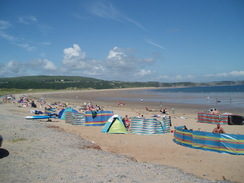
In Oxwich we stopped off for a while to eat some lovely ice creams at a shop, before heading back to the car. It had been a short day, but the variety in the scenery - from beach to dune to ridge - made it one of the best walks that I had done for some time. The company also helped. Before we said goodbye, Jacqui and I went for a paddle in the sea, although I, as usual, went a little bit further. The water was fairly warm, and it was a great end to the walk. After that we dried off and said goodbye; Jacqui was going home to Bromsgrove, and Sencan and I were heading on to Hay-on-Wye for a couple of days to buy some books.
This walk starts off at the car park at the southern end of the beach in Oxwich. Leave the car park and join the beach, and then turn left to start following the beach northeastwards. After a mile Nicholaston Pill is reached; if the tide is out this is easy to wade across; if it is high, then there are a couple of bridges sluightly further inland.
Continue in eastwards along the beach for half a mile, with Nicholaston Burrowa on the left. Just before Little Tor is reached, turn left along a path at the eastern end of the sand dunes. This soon turns to the right and climbs steeply uphill onto Little Tor. When the gradient slackens at the top, turn right along another path. This heads eastwards along the top of the cliffs, dipping down before climbing once more to a stile.
By some limekilns ignore the path leading off to the left and continue straight on to head eastwards along indistinct paths across Penmaen Burrows until it ends at a wide path at the top of the cliffs facing Threecliff Bay. Turn left, and follow this path. It soon becomes firmer underfoot, and then exit via a stile and take a path that heads northwestwards, slowly climbing uphill before ending at the A4118 in Penmaen.
Turn right to follow the road eastwards for about twenty yards, and then turn left up a minor road. This curves to the right and slowly climbs, and then take a track that leads off to the left from SS52858880. This clmibs uphill to the west; climb past a car park and onto the top of Cefn Bryn. At the top there is a covered water tank, and beyond this a half-buried trig pillar. The path descends down to a little beallach, then climbs up once more.
At SS49958955 turn left down another track. This starts descending southwestwards, before entering Hayes Wood. Continue on downhill until the A44118 road is reached by Home Farm. Carefully cross the A4418, and then head southwards along a road for two-thirds of a mile. This descends steeply downhill; the road is narrow, and so care is needed. It starts climbing up the other side of the valley, and near the top turn left along a narrow footpath that climbs up through trees before reaching a stile that leads into a graveyard.
Walk on with the church tower to the left, and then cross a stile to join a lane. Turn left along this lane, and cross a stile to follow a green lane southeastwards. It emerges out into an open field, and then enters some woodland, where ti curves to take a more easterly course. Eventually it emerges from the trees, and heads southwards for half a mile across fields. It ends at a road in Long Acre; turn left to follow the road southeastwards back into Oxwich. At a road junction turn left, and by a ship turn right to re-enter the car park where the walk started.
This makes a total distance of 8.3 miles, with 1033 feet of ascent and 1033 feet of descent.
Please note that I take no responsibility for anything that may happen when following these directions. If you intend to follow this route, then please use the relevant maps and check the route out before you go out. As always when walking, use common sense and you should be fine.
If you find any information on any of these routes that is inaccurate, or you wish to add anything, then please email me.
All images on this site are © of the author. Any reproduction, retransmissions, or republication of all or part of any document found on this site is expressly prohibited, unless the author has explicitly granted its prior written consent to so reproduce, retransmit, or republish the material. All other rights reserved.
Although this site includes links providing convenient direct access to other Internet sites, I do not endorse, approve, certify or make warranties or representations as to the accuracy of the information on these sites.
And finally, enjoy your walking!
Directions
Distances
From To Distance (m) Ascent (ft) Descent (ft) Oxwich Cefn Bryn 4.2 771 187 Cefn Bryn Oxwich 4.1 262 846 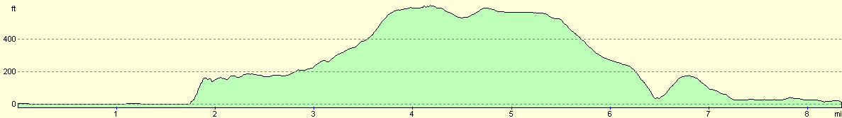
For more information on profiles, ascents and descents, see this page

Disclaimer
Nearby walks
# Title Walk length (miles) 376 Port Talbot to Caswell 16.0 377 Caswell to Port Eynon 11.3 378 Port Eynon to Landimore 18.6
![]() Previous walk
Previous walk
![]() Next walk
Next walk
