Walk #533: Lybster to Helmsdale
 |
 |
|
General Data
| Date Walked | 20/08/2003 |
| County | Highlands |
| Start Location | Lybster |
| End Location | Helmsdale |
| Start time | 09.45 |
| End time | 18.08 |
| Distance | 23.9 miles |
| Description | This was a long road walk, most of it along the A9(T) and only a short section of off-road walking. |
| Pack | Today I carried my 30-litre Karrimor HotRock rucksack, which was filled with my packed lunch, waterproof leggings, water bottle and a couple of spare shirts, together with the usual assortment of odds and ends. |
| Condition | I feel absolutely fine after this walk, despite the length of the walk. My neck and right shoulder were both fine, and my left knee gave me no trouble, which is a good sign. |
| Weather | The day started off very grey, although the wind had died down from last night. It was dry however, and so the walk in the morning was not too bad. Unfortunately whilst I was eating my late lunch it started to drizzle, and this continued for the rest of the afternoon. Fortunately it was never very heavy but it was continuous, and at times when it was blown into my face by the southwesterly wind it was quite unpleasant. One I finished the walk it started to rain more heavily, and I am quite glad that I missed this. |
| OS map | Landranger number 11 (Thurso & Dunbeath) and Landranger number 17 (Helmsdale & Strath of Kildonan) |
 |
 |
|
 |
Map of the walk
Maps courtesy of Google Maps. Route for indicative purposes only, and may have been plotted after the walk. Please let me have comments on what you think of this new format. For a detailed table of timings for this walk, please see the table file.
Notes
As I had mains power I awoke early this morning so that I could do some work on the PC. By seven I had written up all the previous four day's photographs, and this gave me time to catch up with the write-up of the directions. A few cups of coffee helped me with this task, and because of the early start I was ready to start the walk earlier than I had expected.
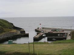
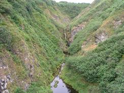
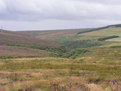
Sam dropped me off back at Lybster, and I strode off down the hill to the nice little harbour. A good path took me up the hill on the other side, and I soon reached the trig point near the top of the cliffs. I then headed west along the top of the cliffs towards Achastle-shore, but I was then faced with a steep valley to cross. At the mouth of the valley I could see a way up on the other side, but I decided to head inland a little way to see if I could find a better way. I soon reached a cottage at Achastle, and I decided that instead of struggling across I would walk up to the A99(T) and follow that instead.
I met Sam at the car park of the North Shore Pottery company in Forse, and we chatted for a while whilst I changed from my boots into my trainers. I soon set off once again southwestwards along the A99(T), and in not time at all I reached the A9(T) junction in Latheron. For the rest of the day I followed the A9(T), which was an easier walk than I had feared, as it was not too busy. I nipped into the butchers in Latheronwheel so that I could buy a pack of crisps, and continued on through Knockinnon towards Dunbeath.
Sam was waiting for me in a lay-by beside the A9(T) to the west of the village, and I went in for lunch. Sam made me some sandwiches, but I was keen to continue on with the walk as I realised that I had fifteen miles still to walk. As I ate it started to drizzle, which did not help put me into the best mood, and I knew that when the drizzle was combined with the wind (which was a southwesterly, and therefore head-on) it would be most uncomfortable. The drizzle put out of my mind any idea of walking along the cliffs instead of the main road, and so I got out of Mervan and continued walking.
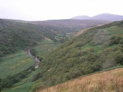
I tried to keep a good pace up as I knew that I had about five hours more walking to do. Walking along the road meant that I often did not get many good views, but those that I did get were expansive, with three oil or gas rigs visible out to sea, and the hills of the Grampian coast just discernable to the south. The next thing of any note was the extremely steep descent down into the small village of Berriedale, where the road goes downhill in a hairpin bend, crossing the river by the war memorial before climbing steeply uphill on the other side of the valley. As I walked down here lorries were finding the ascent on either side of the hill quite hard going, but I managed to make the ascent without getting out of breath or stopping.
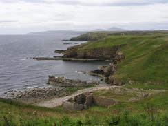
A little further on there is a path running around the side of Inver Hill and I was tempted to walk around this, but I really did not fancy wading through wet heather in the drizzle, and so I just stuck to the road. I was extremely tempted to go down to have a look at the ruins of Badbea village, which has a curious history. Crofters who had been driven off their land started the village on the steep cliffs in the early nineteenth century. The going was so hard that allegedly they used to chain up their cattle and children to stop them wandering off the edge of the cliffs! As I reached the village the drizzle changed into a hard rain, and so I just continued on along the road.
As I walked around the hairpin bend at Ord of Caithness the rain became drizzle once again, and I crossed over from Caithness into Sutherland. Apparently it is unlucky to cross the Ord on a Monday, especially if your name is Sinclair and you are wearing green. Fortunately I passed by on a Wednesday, my name is not Sinclair and the only green that I was wearing was my boxers!
I was sitting in Mervan this evening watching Coronation Street when I had a compelling urge to go out and do a few more miles walk. I had eaten a lovely evening meal, it was still raining, but my legs felt fine and I was ready for a few more miles. Sanity prevailed, however, and Sam persuaded me to stay in Mervan. It is really strange to think that after a long walk I get such urges, but sometimes my body just does not want to stop. Sam had found a nice place to park for the night - we could sit in Mervan and watch a seal swimming about in the harbour, and it is a popular place - three other motorhomes came and parked next to us.
Directions
This walk starts off in the high street of the village of Lybster, at the junction with the road that leads down to the harbour. Descend down this road towards the harbour and once the bridge over the Reisgill Burn is crossed take a distinct path that leads uphill to the right. At the top of the hill climb over a ladder stile and follow a distinct path southwestwards through a field, crossing another stile and then reaching a track near a cottage. Turn left to head south for a few hundred yards down the track until it ends by a trig point and a ruined cottage. Here turn right to walk westwards downhill across moorland until a track is reached near Achastle-shore.
Here I turned right to head northwards along the track past Achastle; it would certainly be possible to continue westwards across the deep valley. After about a mile I reached the A99(T), where I turned left and followed the road southwestwards for a little under two and a half miles, until you reach the junction with the A9(T) in Latheron. The rest of the walk is along the A99(T) for nearly twenty miles, passing through Latheronwheel, Dunbeath, Borgue, Berriedale and Navidale before eventually reaching the village of Helmsdale. Just before the big bridge over the River Helmsdale is reached turn left down a road that leads towards the harbour. This walk ends at the little car park that overlooks the harbour.
Distances
| From | To | Distance (m) | Ascent (ft) | Descent (ft) |
|---|---|---|---|---|
| Lybster | Dunbeath | 8.8 | 807 | 951 |
| Dunbeath | Berriedale | 5.6 | 650 | 673 |
| Berriedale | Helmsdale | 9.5 | 1237 | 1260 |
This makes a total distance of 23.9 miles, with 2694 feet of ascent and 2884 feet of descent.
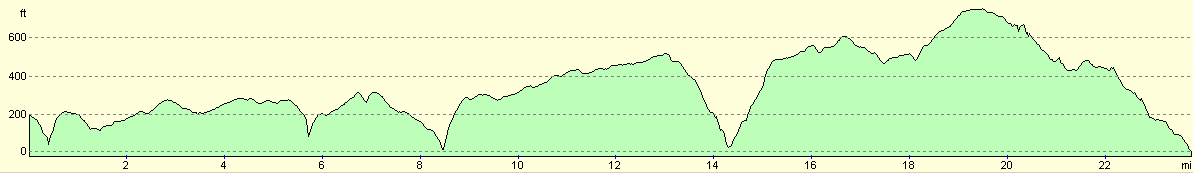
For more information on profiles, ascents and descents, see this page
Accommodation
We spent the night in a little car park beside the harbour in Helmsdale, which was a quite enough place to spend the night.
Disclaimer
Please note that I take no responsibility for anything that may happen when following these directions. If you intend to follow this route, then please use the relevant maps and check the route out before you go out. As always when walking, use common sense and you should be fine.
If you find any information on any of these routes that is inaccurate, or you wish to add anything, then please email me.
All images on this site are © of the author. Any reproduction, retransmissions, or republication of all or part of any document found on this site is expressly prohibited, unless the author has explicitly granted its prior written consent to so reproduce, retransmit, or republish the material. All other rights reserved.
Although this site includes links providing convenient direct access to other Internet sites, I do not endorse, approve, certify or make warranties or representations as to the accuracy of the information on these sites.
And finally, enjoy your walking!
This walk was mentioned in the following routes:
| My walk around the coastline of Britain |
Nearby walks
| # | Title | Walk length (miles) |
|---|---|---|
| 532 | Wick to Lybster | 17.2 |
|
|

|