Walk #841: A circular walk from South Wonston to Itchen Abbas
 |
 |
|
General Data
| Date Walked | 11/09/2009 |
| County | Hampshire |
| Start Location | South Wonston |
| End Location | South Wonston |
| Start time | 09.29 |
| End time | 16.34 |
| Distance | 15.4 miles |
| Description | This was a pleasant walk following trackways to the north and east of Winchester. |
| Pack | Today I carried my 30-litre Karrimor rucksack, filled with waterproofs, a book and other odds and ends. |
| Condition | My feet hurt a great deal during this walk; the effects of Monday's walk not yet having worn off. This made the walk a struggle, although they felt much better after the long, relaxing lunch break. |
| Weather | Today was a warm day, with a mixture of sunshine and light, white cloud overhead. There was not much breeze, and all in all it was a wonderful day for a walk. |
| OS map | Landranger number 185 (Winchester & Basingstoke, Andover & Romsey) |
 |
 |
|
 |
 |
|
Map of the walk
Maps courtesy of Google Maps. Route for indicative purposes only, and may have been plotted after the walk. Please let me have comments on what you think of this new format. For a detailed table of timings for this walk, please see the table file.
 |
 |
|
 |
 |
|
Notes
It had been a few days since my last walk, which had been a little too much of a push for me after so long since my last walk. I decided to do another walk the same week, if only to push myself. I parked in the same place as the last walk - the car park in South Wonston, put my boots on and set off.
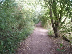
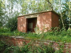
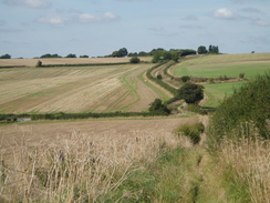
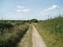
Initially I followed a track that soon reached a filled-in bridge over the trackbed of the old Winchester to Newbury railway line. I descended down and started following the trackbed south. This was a pleasant, tree-lined route, that followed either deep cuttings or embankments. There were not many views to be had, but there was plenty of interest to see, including the usual remaining ephemera of the railways, including a platform complete with waiting shelter. Off to the right, and barely visible, was the Worthy Down military camp.
I enjoyed the stroll, and it was a shame when it had to end. The path split into two; originally the line had split into two, one branch joining the still-extant line to Winchester, and the other forming the now-demolished line that ran to the east of Winchester. The paths are on a high embankment at this point, and it took me a couple of minutes to find a safe way down the steep sides. Once there, I had to backtrack slightly to reach a tall and imposing bridge that headed under the line.
A green track took me under the still-extant railway bridge, and I then ended up in Springvale. Roads took me on towards a tall bridge that used to carry the Winchester to Alton railway line (the eastern part of which is now the Watercress line preserved railway). Here a road took me steeply uphill, then paths took me past the recreation ground in Kings Worthy, and was followed by a steep descent to the A33.
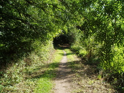
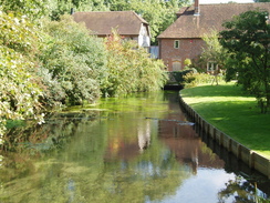
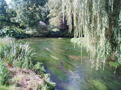
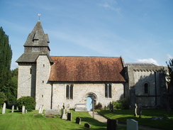
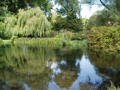
Footpaths took me eastwards near to the River Itchen, where I soon joined the Itchen Way, which I had walked earlier in the year. It was a very pleasant stretch of walk, with picturesque views over the various tributaries of the river. However soon I had to leave the Itchen Way behind, and a subway took a footpath under the M3. What followed was another pleasant stretch of path to the south of the river towards the church in Easton.
It was bin-day in the village, and I had to stop for a few minutes to let the men do their business; the smell from the back of the lorry was quite something. I took a road eastwards out of the village, and then a bridleway that once again cross the River Itchen. Roads took me northwards to another tall bridge under the old Winchester to Alton line; steps led up here, and I found a path running along the old trackbed; I have no idea how far it goes, but it may be fun to find out sometime.
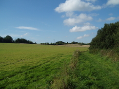
A green lane took me over a hill, and then by a veterinary centre a road took me eastwards. I decided to extend the walk, turning right down a footpath that took me southeastwards towards the Oxdrove Way. I met a woman at the junction with the Oxdrove Way who was collecting blackberries; she was filling a large plastic bag with them as a small terrier yapped at her heels. The Oxdrove Way was narrow here as it squeezed between hedges, and at this point I started to feel more than a little fatigue, especially on my feet.
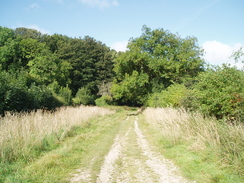
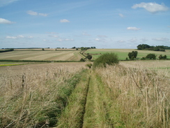
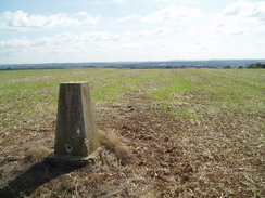
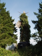
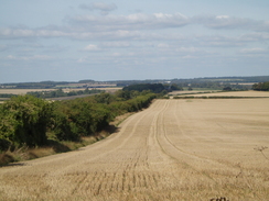
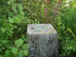
The Oxdrove Way soon reached a complex junction of five paths on Itchen Stoke Down; here I met the Wayfarer's Walk, which I have walked in the past. A long green lane took me northwestwards; I soon reached a place where a trig pillar is marked on the map. I squeezed under a metal-bar gate and headed across the field to the trig pillar; there were some pleasant views to the south and east. The field was bordered by an area of waste land, in which many sunflowers were growing wild. Towering above them were the ivy-clad rusting remains of an old wind pump.
I headed back towards the gate and sat down to eat my sandwiches. It was a lovely spot, and I took my boots off and started to read a large book containing all the Sherlock Holmes stories. It was a beautiful day, and it felt superb to be sitting down in the grass reading such great literature. A woman walked past with two dogs, and I wondered what I looked like; a dirty, dishevelled walked lying in grass whilst reading a thick book.
I spent far too long in the grass, and then pulled my boots on and started hobbling off. My feet were not in good condition by this time, and it took a while to get up to speed. The green lane started descending, and then winding around before ending at a road near Itchen Wood. This was not too busy, and I was soon at the bridge that carried the M3 over the road. On the other side there was a signpost marking it as being a meeting point; the northbound Winchester North services are nearby, and this is obviously where people are evacuated to in an emergency.
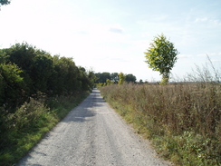
The road met the A33 near a brethren's meeting house; I crossed this and the started along a green lane called Alresford Drove. It was a bit stony underfoot, but soon I reached the top, which is right above the northern portal of the Wallers Ash railway tunnel. I had walked here on my previous walk to try and find the trig pillar that is marked on the map, but had been too tired to spend long finding it. This time there was a man at the small gate, and I ended up chatting. He owns the gun club immediately behind the trig pillar, and he invited me in to see it. I climbed a steep bank to reach the pillar, which is on the spoil that had been dug out of the tunnel. Unfortunately the surrounding overgrown vegetation cut off any views. Afterwards he offered me a cup of tea, and I settled for a soft drink inside the clubhouse. It was an interesting chat with three or four other people present, but eventually I had to head off.
The drove continued westwards before ending at a road. Here I continued along another road, which soon passed over the old Winchester to Newbury railway line once again, the course of which was now infilled. I could only tell that it was once a railway by the brickwork of the old bridge parapet. Soon I turned left to head south through South Wonston; off to the left I came across an old long barrow on an area of grass; it was very difficult to see the outline of the barrow, but the information board was quite helpful.
A little further on I reached the car park and my car. It had been another long walk, but despite my aching feet it had been an enjoyable one. I certainly felt in a much better state than I had on the previous walk, which was not that difficult. The conversation with the people at the Wallers Ash gun club had been entertaining, and the whole day had been well worth it. This is hardly a classic walk, but neither is it a particularly bad one.
 |
 |
|
 |
 |
|
Directions
This walks starts off at the car park by the playing fields in South Wonston. Leave the car park and then, just before the road starts, turn right to head eastwards along a track for a third of a mile until an old railway bridge is reached; here turn right down a steep slope to reach a path that runs under the old bridge. Turn right and start following this path southwards for a little over a mile until the old railway trackbed starts to split into a fork; you can tell when this occurs because the trackbed crosses two separate bridges side-by-side. At this point the trackbed is on a tall embankment, carefully make your way down by one of the paths, and then head under the old trackbeds using the two adjacent bridges.
A track leads away on the other side to the east; it soon passes under another tall railway bridge which carries the still-extant London to Winchester line overhead. On the other side the track turns sharply to the left and soon becomes Hookpit Farm Lane. This heads northeastwards before curving to the right to end at Springvale Road. Turn right and head southwards for a third of a mile until another old road bridge heads overhead. Pass under this bridge and immediately turn left down Legion Lane. This almost immediately curves to the right and starts heading steeply uphill to the southeast.
When the road curves to the left continue straight on along a footpath that passes a recreation ground on the left. When this ends a track called Hinton House Drove plunges downhill to end at the A33. Turn right and follow the A33 southwards for a hundred yards or so; a road comes in from the left, and shortly after thus turn left down a footpath. This heads eastwards on the northern side of the River Itchen; when it meets the end of Mill Lane turn right, following the Itchen Way. This heads south across the floodplain between tributaries of the river, before eventually crossing another large stream by a house. Go through a stile by a gate, and then turn left, leaving the Itchen Way behind and joining the Three Castles Path.
Thus heads northeastwards with the river on the left; it soon passes under the M3 using a culverted subway. On the other side the path turns sharply to the right, paralleling the M3 for a few yards, before turning to the left to head eastwards for a little under half a mile with a field boundary on the left. Just before the church is reached turn right to go through a small play area towards Easton church. The path ends at Church Lane; follow this eastwards until it ends at another road junction. Turn right and then left to head eastwards through Easton. At another junction turn left to head north past a pub, and then follow the road as it curves to the right to head eastwards.
After about half a mile a footpath leads off to the left at SU521323. Follow this footpath as it heads across the floodplain to cross the River Itchen on a couple of bridges. When the footpath ends on the other side, head north up Chilland Lane until it ends at the B3047 road in Chilland. Turn right along the B3047 for a few yards, and then turn left up Chillandham Lane. This soon passes under an old railway brodge, and immediately afterwards turn right along a green lane.
This climbs uphill to the northeast for three-quarters of a mile, ending at a junction with Northington Road by a veterinary Centre. Continue straight on eastwards along this road for a little over half a mile until a track leads off to the right at SU543339. Turn right and follow this track as it heads southeastwards across fields for half a mile until it ends at a T-junction with another track called the Oxdrove WAy at SU548333. Follow this northwestwards for nearly two miles; it soon crosses a road and then passers over a hill. Near the end the track winds around slightly before ending at a road.
Turn left and follow this road westwards for a little over a mile as it passes under the M3 before ending at the A33. Carefully cross the road and then continue straight on along Alresford Drove for a couple of miles. When this ends at a road at Wallers Ash continue straight on westwards along another road for three-quarters of a mile until it curves sharply to the left to become West Hill Road North. Follow this road southwards for a third of a mile until it ends at the car park by the recreation ground where this walk ends.
Distances
| From | To | Distance (m) | Ascent (ft) | Descent (ft) |
|---|---|---|---|---|
| South Wonston | Chilland | 6.1 | 323 | 417 |
| Chilland | M3 | 5.3 | 464 | 354 |
| M3 | South Wonston | 4.0 | 128 | 144 |
This makes a total distance of 15.4 miles, with 915 feet of ascent and 915 feet of descent.
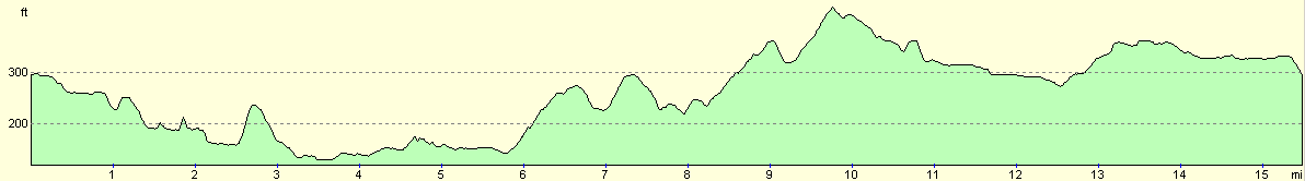
For more information on profiles, ascents and descents, see this page
 |
 |
|
 |
 |
|
 |
 |
|
 |
Disclaimer
Please note that I take no responsibility for anything that may happen when following these directions. If you intend to follow this route, then please use the relevant maps and check the route out before you go out. As always when walking, use common sense and you should be fine.
If you find any information on any of these routes that is inaccurate, or you wish to add anything, then please email me.
All images on this site are © of the author. Any reproduction, retransmissions, or republication of all or part of any document found on this site is expressly prohibited, unless the author has explicitly granted its prior written consent to so reproduce, retransmit, or republish the material. All other rights reserved.
Although this site includes links providing convenient direct access to other Internet sites, I do not endorse, approve, certify or make warranties or representations as to the accuracy of the information on these sites.
And finally, enjoy your walking!
Nearby walks
| # | Title | Walk length (miles) |
|---|---|---|
| 709 | South Downs Way: Winchester to Wether Down | 20.4 |
| 787 | Romsey to Eastleigh via Winchester | 21.1 |
| 789 | A circular walk from Mottisfont to Fullerton | 21.4 |
|
|

|