Walk #842: A circular walk from Calshot to Exbury and Fawley
 |
 |
|
General Data
| Date Walked | 27/01/2010 |
| County | Hampshire |
| Start Location | Calshot |
| End Location | Calshot |
| Start time | 08.25 |
| End time | 15.25 |
| Distance | 17.4 miles |
| Description | This was a pleasant walk following both the coast and crossing a small part of the New Forest. |
| Pack | Today I carried my 30-litre Karrimor rucksack, filled with waterproofs, a flask and other odds and ends. |
| Condition | As was to be expected after such a long lay-off from walking, I have two blisters on my toes, one quite large. Aside from this I feel fine. |
| Weather | The day was mostly dry and cloudy, except for a short burst of rain in the early afternoon. It was not a warm day, but was nowhere near as cold as it had been recently. |
| OS map | Landranger number 196 (The Solent & The Isle of Wight, Southampton & Portsmouth) |
 |
 |
|
 |
 |
|
Map of the walk
Maps courtesy of Google Maps. Route for indicative purposes only, and may have been plotted after the walk. Please let me have comments on what you think of this new format. For a detailed table of timings for this walk, please see the table file.
 |
 |
|
 |
 |
|
Notes
It had been quite a few months since my last walk; a series of factors having prevented me from getting out. I vowed to restart in early January, but the poor weather rather discouraged me from doing any drives to the walks - with hindsight a shame, as the New Forest or the South Downs would have looked wonderful. Today's weather forecast looked reasonable, so I decided to do an easy walk to get myself back into the walking habit. Over the last couple of years I have been revisiting parts of my coastal walk, and so I decided to do the short stretch of coast between Fawley and Exbury.
It was an enjoyable drive to the New Forest; I wanted to park by Fawley Church, but this was right by one of the entrances to the Fawley BP refinery. It did not feel like a good place to park, so I headed south to a car park by the beach in Calshot. A brilliant red sky shone as I drove, and I parked up in the car park (free in winter) and walked over to the beach. Unfortunately most of the red sky had disappeared by this time and the skies across the Solent to the Isle of Wight were hazy, but it still felt brilliant to be standing on the shingle as the surf crashed around my boots.
There is not path westwards along the coast between Calshot and Lepe, so I followed roads slightly inland. In Calshot I passed rows of identical houses, all in the shadow of the giant chimney of Fawley power station. The power station and refinery must be the major employers in this area, and I wonder what it will be like if they were both to shut (the power station is already partly closed). The road walk was long, but there was always plenty to see.
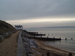
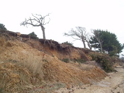
In Stone I saw some flowers arranged around the base of a tree with a large area of stripped bark, the after-effect of a car crash that had killed a man. It put me in a sombre mood as I headed south back to the sea by the Lepe Country Park. The skies were slightly clearer by now, granting me better views across the Solent. The path follows the seawall past a white house called the Watch House (rightly so, as it has a bay window looking out over the water), after which it joined the beach. The sandy cliffs on my right showed signs of fast erosion; trees were on the beach, and roots of others protruded like twisted pieces of wrought iron. A little further on there was a place where the entire cliff had slumped down. Needless to say, this path would be impassable at high tides.
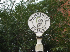
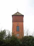
The going became slightly easier when a flatter, grassy area was reached, but this soon ended as the path crossed a small median strip between mudflats and low cliffs. It was not hard going, and it was a disappointment when the path ended at a road near a quay in Lower Exbury. The way along the coast is blocked by the Beaulieu River, the first crossing point of which is the village of Beaulieu itself. A long road walk north followed. I got glimpses of the frontage of Exbury House before I reached Exbury itself, which is dominated by a brick water tower.
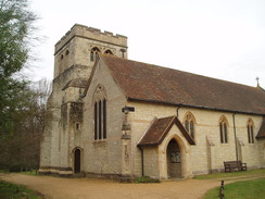
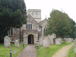
I nipped into the church to have a quick look around - unlike many, it was unlocked. The vaulted barrel roof took my view towards the altar, and although it was slightly dark inside I felt like there was something missing. When I read the history notes for the church I found out what - the church was built in 1827, replacing a 13th Century church nearer the mouth of the river. I was missing a sense of history, a sense of permanence. Despite its relative youth, the church has had two major rebuilds.
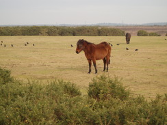
A road took me northwards. In Exbury I passed Exbury Gardens, home of the world-renowned Rothschild Collection of rhododendrons, azaleas, camellias and rare trees and shrubs. There is a small narrow-gauge railway there, and I passed the station as I headed northwards. The next mile and a half took me through undistinguished woodland, before it opened up into the open heathland that the New Forest is famous for. For the first time today I saw some New Forest ponies, and a little later on I reached the Royal Oak pub, seemingly situated in the middle of nowhere.
I decided to go in for a rest. Inside was light and airy, and I was soon sitting down with a pint of Abbot and another of orange and lemonade. I had brought a book with me, so I sat down for forty minutes and read. There is one notable feature of the bar - there is a list of all the licensees since 1846 on the reverse of the bar flap, a fascinating addition.
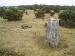
Once leaving the pub I left the route of my coastwalk and headed north along the Beaulieu Road. As usual this was not too busy, and I could easily walk onto the adjacent moorland as cars came. On my previous walk along this road I had visited the trig pillar, which is situated amidst the gorse to the west of the road. On my previous walk I found this with no problem, but today I was left wandering around in the gorse, leaving a funny, winding track on my GPS tracklog. Eventually, just as I was giving up, I saw it through the gorse, within easy view of the road. I took a few photographs and headed on.
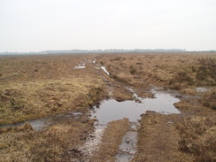
My route now took me straight across the moorland to the east. The path was easy to follow underfoot, and the going was not too wet despite the recent snow and rain. Indeed it was a magnificent walk; not the best that the New Forest has to offer, but welcome after the long road walk. The path angled towards some trees, before crossing a stream at Hardley Bridge. On the other side I found a burnt-out car, and headed down to join the A326 road at a roundabout in Hardley.
The next few miles followed the A326 southeastwards; a boring walk with not much to see. There is a big social centre for the nearby BP works and lots of shops, none of which attracted me in. After a while the shops ended and I walked along a pavementless road, with glimpses of the massive BP works just visible through the trees to the left. It was a welcome relief when I could leave the main road behind and take a minor road towards the refinery. There was a good off-road path to the left that took me onwards as it started to rain heavily.
The same heavy smell of oil hung around Fawley Church when I arrived, and I nipped into the dry interior. It was pleasant inside, and I was surprised to find that the Christmas Nativity scenes were still in place at the end of January. After a quick prayer I left to find that the rain had stopped - someone had evidently been listening!
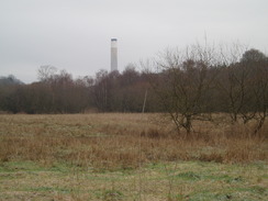
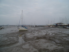
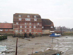
Fawley is a small village, and again seems to be dominated by the refinery. I headed out, descending downhill to the quay at Ashlett, where there is a small pub. A large supertanker was visible in Southampton Water, past a large building that I guess was once a water-powered mill. A boggy path took me southeastwards, skirting the coast before becoming firmer as it approached the massive, dominating presence of Fawley power station. The sheet bulk of the place is quite breathtaking - two buildings and the massive chimney dwarfing everything else. Originally built in 1971 to generate 2GW of power, it now only generates half of that, and is only used at peak times. On the other side of the fence were three coils of razor wire, gleaming as if brand new. I guess they do not want any climate protesters in their grounds...
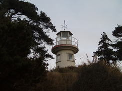
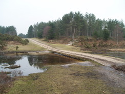
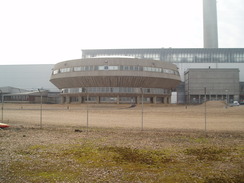
There is a strange round concrete structure, looking a little like a UFO with windows, which I guess is the control room. A little further on there was a swing bridge over an inlet that would allow ships right up the power station. After this the path continued on, with the power station receding behind and the buildings at Calshot Spit growing larger to the right. The Coastguard Tower that controls sea traffic in Southampton Water and the Solent was clearly visible, just behind which was Henry VIII's Calshot Castle.
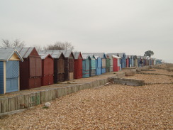
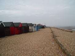
The path ended at a road by a seemingly never-ending row of beach huts. I headed down across the sea to the shingle before rejoining the road in a car park - by this time my feet were hurting me, a sign that I have not done much walking recently. I followed the road as it swept me past the multi-coloured beach huts, all seemingly in good condition and well looked after. It was a relief when I reached my car, having had a thoroughly enjoyable walk.
 |
 |
|
 |
 |
|
Directions
This walk starts at the large car park in Calshot, near to the toilets and the lifeboat station. Walk towards the lifeboat station and beach huts,m then turn right to head up a little hill. Follow the road as it turns to the right, descending to meet another road at the end of the car park. Continue along the road as it heads north, passing rows of houses on the right. Near the brow of a hill turn left down Tristian Close. At the end of the close then turn right down a short little access road. At the end of this road a gap in a chain-link fence allows access to a footpath.
Turn left along this footpath and follow it as it heads westwards for a couple of hundred yards through an area of trees until it ends at Stanswood Road. Turn left down this road and follow it as it heads southwestwards for one and three-quarter miles, passing Stanswood Farm until it ends at a T-junction with Lepe Road. Turn left to head southwards down another road for 0.6 miles until it reaches a car park beside the sea at Stone Point.
The road curves around to the right by the car park to head westwards towards Lepe. When the road curves slightly to the right, continue straight on to the west along a footpath that runs along the top of the seawall to the right of a white house called 'the Watch House'. When the seawall ends the path continues on along the beach for a mile below some low cliffs past Inchmery House before it meets the road once again. This path may be impassable at high tide; it was not a nice path to walk along even when the tide was low. When the path meets the road once more turn left along it and follow it as it swings to the right to head northwards for a mile to the church at Exbury.
Continue on as the road heads northwestwards through a pleasant wooded area for two and a half miles, passing the Forestry Commission Moonhill car park before ending at a T-junction with another road. Turn left down this road for about fifty yards to another T-junction with the B3054 road beside the Royal Oak pub.
Take the second road off to the right, the B3054, and follow this northwards for three-quarters of a mile. At SU404045, turn right and start following a path that heads eastwards across the moor. In places this is indistinct, so angle towards the trees of Fawley Inclosure on the left. It becomes a firm track as it nears the trees, and plunges down to cross a stream at Hardley Bridge. Climb up the other side and then continue along the path towards the A326 road.
Before this is reached, turn right to head eastwards across the moorland through a large gap in the trees towards a pylon of a high-voltage power line. Pass this, and then go through a gate. A path on the other side skirts between the road on the left and industrial buildings on the right, before reaching a road. Turn left along this road to a roundabout, and then turn right to join the A326.
Follow the A326 as it heads southeastwards for a little over a mile until a roundabout with the B3053 is reached. At the roundabout turn left down the B3053 and carefully follow it for 0.8 miles towards Fawley. Take the first road to the left, Church Lane, which heads northeastwards to the church in Fawley.
From Fawley Church, retrace your steps along Marsh Lane for about a hundred yards before turning to the left down Church Lane. In the village take the second road to the left, Copthorne Lane, and when this road turns to the left turn right to follow another road. This road curves around before it forks. Take the left-hand fork and follow the road as it passes to the left of a white house and descends downhill to the Jolly Sailor pub in Ashlett.
At the pub turn right and walk past the quay. Pass through a gate and down a track that then turns to the left to reach a marina. When the track enters the marina at a cattle grid turn right and walk across a field. This path meets the shore and continues into an area of sparse woodland where a better path leads onwards to the southeast towards the large power station.
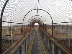
When it meets a chain link fence guarding the power station that path turns left alongside the fence for a short distance before turning to the right. The path passes the power station before crossing an inlet using a heavily fenced footbridge before the chain link fence ends on the right. When this happens continue straight on down a track until it reaches a road beside the beach and some brightly coloured beach huts to the northeast of Calshot.
Turn right to walk southwestwards along the road towards the main car park in Calshot, where this walk started.
Distances
| From | To | Distance (m) | Ascent (ft) | Descent (ft) |
|---|---|---|---|---|
| Calshot car park | Exbury church | 6.2 | 177 | 108 |
| Exbury church | Fawley church | 7.9 | 144 | 121 |
| Fawley church | Calshot car park | 3.3 | 62 | 154 |
This makes a total distance of 17.4 miles, with 383 feet of ascent and 383 feet of descent.
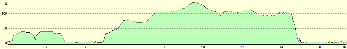
For more information on profiles, ascents and descents, see this page
 |
 |
|
 |
 |
|
Disclaimer
Please note that I take no responsibility for anything that may happen when following these directions. If you intend to follow this route, then please use the relevant maps and check the route out before you go out. As always when walking, use common sense and you should be fine.
If you find any information on any of these routes that is inaccurate, or you wish to add anything, then please email me.
All images on this site are © of the author. Any reproduction, retransmissions, or republication of all or part of any document found on this site is expressly prohibited, unless the author has explicitly granted its prior written consent to so reproduce, retransmit, or republish the material. All other rights reserved.
Although this site includes links providing convenient direct access to other Internet sites, I do not endorse, approve, certify or make warranties or representations as to the accuracy of the information on these sites.
And finally, enjoy your walking!
Nearby walks
| # | Title | Walk length (miles) |
|---|---|---|
| 305 | Tipner to Browndown | 18.9 |
| 306 | Browndown to Bursledon | 12.9 |
| 307 | Bursledon to Southampton | 9.2 |
|
|

|