Walk #843: A circular walk from Bramshaw Telegraph to Frogham
 |
 |
|
General Data
| Date Walked | 09/02/2010 |
| County | Hampshire |
| Start Location | Bramshaw Telegraph |
| End Location | Bramshaw Telegraph |
| Start time | 08.15 |
| End time | 14.20 |
| Distance | 17.4 miles |
| Description | This was a very pleasant walk through the New Forest, although perhaps with a little too much road walking. |
| Pack | Today I carried my 30-litre Karrimor rucksack, filled with waterproofs, a flask and other odds and ends. |
| Condition | I am feeling fairly bad after this walk; fatigued and with blistered feet. |
| Weather | Today was a mixed day with bright sunshine, heavy hailstorms and gusting winds, sometimes all at the same time. |
| OS map | Landranger number 184 (Salisbury & The Plain, Amesbury) and Landranger number 195 (Bournemouth & Purbeck, Wimborne Minster & Ringwood) |
 |
 |
|
 |
 |
|
Map of the walk
Maps courtesy of Google Maps. Route for indicative purposes only, and may have been plotted after the walk. Please let me have comments on what you think of this new format. For a detailed table of timings for this walk, please see the table file.
 |
 |
|
 |
 |
|
Notes
It had been a couple of weeks since my last walk. This was due to a combination of circumstances, part of which were the blisters I had got on the previous walk. These had healed, and as Sencan was away at the ISSCC this week, I decided that, whilst the cat was away, the mouse would walk.
I had planned several walks visiting trig pillars around the New Forest, and I decided to do one of these today. The weather forecast seemed relatively good today, so I was looking forward to a good day. The drive went well, and I was soon pulling up in the car park at the strangely-named Bramshaw Telegraph. It took me a few minutes to get my things together and I realised that, for the first time in years, I had forgotten spare batteries for my GPS. I had plenty of AAA batteries for my MP3 player, but nothing no AA batteries. A set of batteries for my GPS will often last for a couple of days and, when I checked, they were nearly dead.
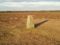
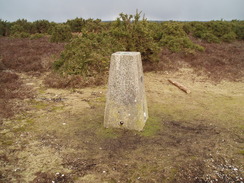
As I already had my boots on I decided to head off. The sun was straight into my eyes as I followed the B3078 road. The traffic was fairly heavy but the verges were wide and the walking was easy. My first target was the trig pillar on Longcross Plain, and it was a relief when I left the main road and joined a minor road that headed south across the plain. The trig pillar soon became visible off to the left; the grey, unpainted concrete merging in surprisingly well with the surrounding brown moorland. Waterlogged ground surrounded the pillar, it proved easy enough to reach and photograph.
Back on the road, I headed past Fritham Lodge and Fritham House - an attractive building that is now a nursing home. The walk south was a bit of a slog, and I then turned along another road that headed across Janesmoor Plain. The first mile of this was arrow-straight and level, with strange regular, filled-in manholes in concrete off to the right. Indeed, it made me think that this road might have at one stage been a runway. When the road finally curved away there was an impression in the grass of where the runway might have once curved into a taxiway.
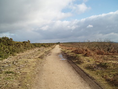
I had planned to head off-road through Slufters Inclosure, but instead I continued along the road for a while before taking a path that headed south. My target was a trig pillar just to the north of the A27, and traffic noise soon started intruding. The pillar soon became visible a short distance away to the left, and I headed along to it before heading back along a track.
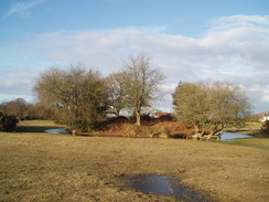
A gate led into the Roe Inclosure, which was a pleasant walk up and down through the woodland. Near the top of the final incline was a white building called Roe Cottage, pretty in its woodland setting. A road was joined shortly afterwards, and I took this westwards, passing a pub on the way. The last stretch of this narrow road was particularly pretty as it wound and climbed up a slight hill.
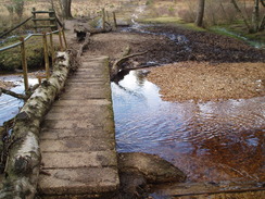
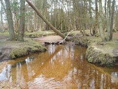
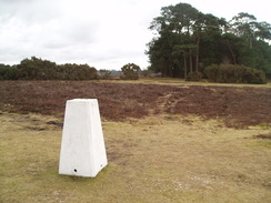
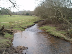
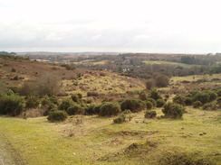
A muddy path took me down to Dockens Water, where a narrow bridge -covered with driftwood swept down by a flood - helped me across the particularly attractive stream. On the other side a path led steeply uphill, allowing good views to develop to the south. The moorland at the top of the climb was superb, and I enjoyed the stroll along as finally my GPS gave up the ghost. I stopped for a few minutes to have another search through my pack, then headed towards the trig pillar on the moorland. Unlike the previous two this had been painted white and stuck out like a sore thumb - easy to find.
The next stretch showed me how much I have become used to using my GPS when navigating - I found my way in the right direction across the moorland, but the many paths and tracks on the ground made this interesting. I did not get lost, but it made me realise how much I rely on it just to check my position.
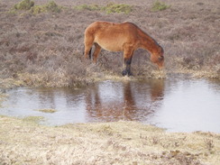
Eventually the path descended down to a road by a stables in Ogdens, and then climbed over Hyde Common to reach Frogham. I had been looking forward to stopping at the pub marked on the map, but it was shut. Unfortunately I was starting to have a little discomfort from my feet, but I pressed on nonetheless. The road passed a car park and a viewpoint, before descending down to Abbots Well. This feature was marked on the map, and was covered with a few wooden planks that were easy to lift using a ring. The water inside was brackish and covered with a layer of scum - the last thing I would want to drink.
A pleasant, easy track took me up onto Hamnpton Ridge, where the final trig pillar of the day was to be found. My feet were really hurting by now, so I sat down on the damp ground with my back against the pillar and watched the clouds roll by. Rather typically, the moment I sat down it started to hail. Fairly soon the front of my coat was white with hail, but I did not feel too cold. Unfortunately my morale did decrease as well. Sencan and I had walked here a couple of days after our wedding, and I was missing her.
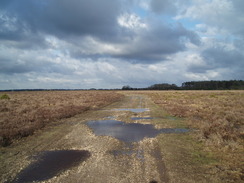
I stopped for about twenty minutes, and by the time I set off once again I was feeling really down. My feet hurt a great deal, and instead of taking the more scenic route that I had planned, I took a more direct route along tracks. The first stretch followed good cycle paths, but after passing a large tumulus another track took me northeastwards. This was not so god, and frequently large pools of water blocked the way. I was hobbling by now, and my pace had really slowed down.
Seeing my car in the car park came as a great relief. I felt more tired than I have after a walk for years; utterly fatigued and lacking energy. To say the least, I was not feeling very good. Much of this was mental rather than physical, and it was a shame that a series of factors - the weather worsening, running out of batteries and my feet hurting - all combined to put me into this low funk. I'm going to have to come back here sometime to do this walk again in good weather, as some of the scenery is beautiful.
 |
 |
|
Directions
This walk starts off at the car park at Bramshaw Telegraph, a few yards away from the junction of the B3078 and B3080 roads. Leave the car park and follow the B3078 as it heads southeastwards for about a mile. When a crossroads is met at SU244155, turn right down another road. This turns to the left across Longcross Plain. Soon a road comes in from the left; continue straight on and pass Fritham House on the right.
When a road junction is reached near SU246130, turn right and follow this new road as it heads southwestwards. Near Cadman's Pool it curves to the left. At another road junction at SU218103, turn left to take another road southeastwards for about a hundred yards. Just before a left-hand curve turn right down the first of two paths. This heads south across moorland with the trees of Milkham Inclosure off to the right.
Continue on until the path meets a track at SU216089. There is a trig pillar a short way away to the left. If you do not want to visit it, turn right to heads westwards. After ha;f a mile the track reaches a gate; go through it to enter Roe Inclosure. Follow the track for a mile through the inclosure as it heads westwards, descending down to cross a stream before climbing up once again. At the top of the hill the track meets a road. Turn left and follow this road westwards, initially heading downhill, passing a pub on the right to reach Appleside Bottom.
Shortly after some trees start on the right, turn right down a track at SU173089. This descends to cross a stream called the Linwood Bog (there is a narrow bridge). On the other side a path climbs steeply uphill to the northwest. There is a confusion of paths at the top, but at SU169095 turn right to head northeastwards, aiming for the northern end of the Whitefield Plantation, where there is a trig pillar.
From the pillar head northeastwards for a little over a mile until SU181113, and then turn left to start heading northwards along the top of the hill, with the heads of valleys off to the left. At SU180117 it starts descending, meeting the end of a track by a stables at Ogdens. Follow this track down to a road. Head straight on down the road as it crosses the Huckles Brook, and when the road curves to the left shortly afterwards, turn right along a track.
After a few yards turn left and climb uphill. Cross an unfenced road and climb uphill to the northwest across Hyde Common. Aim for some houses, and then turn left down a track that brings you out on a road by a chapel in Frogham. Turn right up this road, and then after a short distance at a crossroads turn right. Follow this road as oit heads eastwards, passing a pub on the left. It soon descends and passes the Abbots Well on the right.
Here the road curves sharply to the left. Continue straight on along a good track that climbs uphill to the northeast. Remain on this track as it reaches the Hampton Ridge (passing a trig pillar a short distance away on the left), and continue eastwards along the track as it follows a fairly level course.
Shortly after it passes a tumulus on the left some trees are reached at SU202141. Here leave the track and take a less distinct path off to the left; this skirts the trees on the right and continues northeastwards until it reaches another, more visible track at SU208144. Turn left and follow this track as it heads northwards for two miles with Islands Thorns Inclosure nearby on the right. The track slowly curves to take a more northeasterly, and then easterly, course, before reaching the car park at Bramshaw Telegraph, where this walk started.
Distances
| From | To | Distance (m) | Ascent (ft) | Descent (ft) |
|---|---|---|---|---|
| Bramshaw Telegraph | Linwood | 8.5 | 305 | 499 |
| Linwood | Frogham | 4.3 | 370 | 331 |
| Frogham | Bramshaw Telegraph | 4.6 | 335 | 180 |
This makes a total distance of 17.4 miles, with 1010 feet of ascent and 1010 feet of descent.
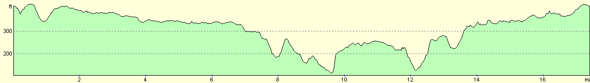
For more information on profiles, ascents and descents, see this page
Disclaimer
Please note that I take no responsibility for anything that may happen when following these directions. If you intend to follow this route, then please use the relevant maps and check the route out before you go out. As always when walking, use common sense and you should be fine.
If you find any information on any of these routes that is inaccurate, or you wish to add anything, then please email me.
All images on this site are © of the author. Any reproduction, retransmissions, or republication of all or part of any document found on this site is expressly prohibited, unless the author has explicitly granted its prior written consent to so reproduce, retransmit, or republish the material. All other rights reserved.
Although this site includes links providing convenient direct access to other Internet sites, I do not endorse, approve, certify or make warranties or representations as to the accuracy of the information on these sites.
And finally, enjoy your walking!
Nearby walks
| # | Title | Walk length (miles) |
|---|---|---|
| 793 | Brockenhurst to Romsey | 24.0 |
| 796 | Romsey to Salisbury via Dean Hill | 23.6 |
| 801 | A circular walk from Brockenhurst to Burley | 23.5 |
|
|

|