Walk #801: A circular walk from Brockenhurst to Burley
 |
 |
|
General Data
| Date Walked | 04/12/2007 |
| County | Hampshire |
| Start Location | Brockenhurst station |
| End Location | Brockenhurst station |
| Start time | 07.42 |
| End time | 16.27 |
| Distance | 23.5 miles |
| Description | This should have been a pleasant walk through the New Forest, which was unfortunately slightly spoilt by the weather and boggy ground underfoot. |
| Pack | Today I carried my 30-litre Karrimor rucksack, filled with waterproofs, a book and other odds and ends. |
| Condition | I feel absolutely fine after this walk. |
| Weather | The day was cloudy, with frequent prolonged periods of light drizzle. These were not heavy enough to force me to put my coat on, and it was surprisingly mild for the time of year. |
| OS map | Landranger number 196 (The Solent & The Isle of Wight, Southampton & Portsmouth) and Landranger number 195 (Bournemouth & Purbeck, Wimborne Minster & Ringwood) |
 |
 |
|
 |
 |
|
Map of the walk
Maps courtesy of Google Maps. Route for indicative purposes only, and may have been plotted after the walk. Please let me have comments on what you think of this new format. For a detailed table of timings for this walk, please see the table file.
 |
 |
|
 |
 |
|
Notes
The forecast for the day looked rather unpromising, but it was a week since my last walk, and so I decided to go for a relatively local one. When I moved down to Hampshire a couple of months ago I planned a series of local walks, and it seemed sensible to do one of these. Sencan had an appointment this evening that I had to drive her to, and so it was essential for me to be back in Romsey so that I could be back in time to pick her up from work.
The drive down to Brockenhurst did not take too long, and I listened to some Podcasts during the journey, and delayed my start by a few minutes whilst a fascinating military history podcast finished. After buying a ticket for the car park I got my kit together and headed down the road.
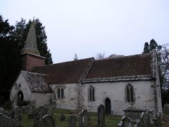
Initially the route followed a road uphill to the pretty little St Nicholas' Church - apparently the oldest in the New Forest, founded before 1086 - and I went into the graveyard to try and get some photos of it. As I was in a hurry I did not stay too long and instead walked on down the road to find the bridleway that would lead me onwards. Instantly the path was fairly muddy, and it started to drizzle as I followed the path down to a stream and then up through the trees.
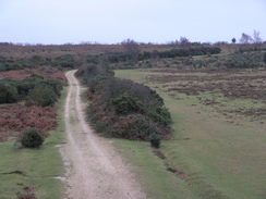
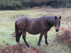
Fortunately the drizzle soon ended, but I was left with a pretty nondescript plod through woods back towards the A337 main road. After this it started to get more interesting, as the next road took me westwards past Latchmoor House, and for the first time today I actually got glimpses of the classic New Forest scenes - ponies walking along through the low heathland.
After passing under a couple of railway bridges (the first carrying the freight-only line to the oil refinery at Fawley, the other the Southampton to Bournemouth route) a track took me across yet more New Forest scenes towards Cater's Cottage, where there was a whitewashed cottage that was obviously an old level crossing cottage.
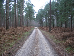
The next few miles westwards followed an old railway line, and in places there were some very pleasant views over the heathland on either side of the road. I enjoyed the stroll, especially at the times when I could identify various pieces of woodwork or ironwork that still remained from when this had been a railway line. The path followed cycle route, and it was a shame when the old railway line ended at a road.
I continued on along the cycle route as it crossed Avon Water at Wooton Bridge and then plunged onto a winding course through woodland. This was not too bad a walk, and was only spoilt when the A35 road was reached - a noisy and ugly scar across the countryside. After this a road and then paths took me towards the Holmsey Caravan Park.
As I followed a track around the outside of the park I started to guess that it had been an airfield sometime in the past - it did not look like one on the map as the outlines of runways were not present, but what I was walking along looked like a perimeter track way. I was pleased when, near the corner of the site, I reached a memorial commemorating the land's use as the RAF Holmsley South airfield during the war! This had been used by RAF Coastal Command and then the USAAF. I later found out that I had been walking along the northern perimeter track of the airfield with the old runways (since removed) to the south of me, and not the western one as I had expected.
A long road walk took me to Cross Ways, and then another road northwards towards Burley. On this latter leg an old bridge took the road over the remains of the same railway line that I had walked along earlier. Here it was in a cutting, and looked more like a canal than a railway as it was flooded, seemingly to quite a depth.
As I walked through the outskirts of Burley I was surprised to see a pony wandering around the world, seemingly oblivious to the couple of cars that it was holding up.It nonchalantly walked straight down the centre of the road, before eventually deigning to walk onto the verge to let them past. I was in need of a rest, so I went into the Burley Inn for a drink and a snack to eat.
Feeling more fortified I set off, once more following roads for the first section and then a track eastwards. After a while I needed to divert off to the north, and although the path I was looking for was hard to find I just cut cross-country until I found the road.
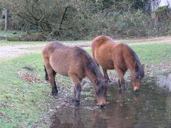
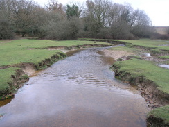
This part of Burley was very sleepy, and there was a herd of ponies in the road. As I walked along past the houses they followed me before eventually stopping at a little pond for a drink. Here I left the road and headed across heathland to a little footbridge over Mill Lawn Brook. There was a pool of water at the base of the steps leading up to the bridge, and the situation was worse on the other side. I managed to circumvent both these pools without getting my feet wet, and continued on along a path that entered some scrub heathland, with scattered trees all around.
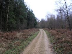
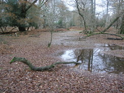
Navigation was not the easiest around here, but somehow I managed to find myself at the correct spot on the A35.A track took me east across ground that looked like it could be swampy at times, and then another led northwards through the Vinney Ridge Inclosure. By this time I was getting a little fed up with walking through trees as I much prefer the open heathland. The path crossed the Rhinefield Ornamental Drive, although it did not look too ornamental to me.
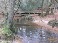
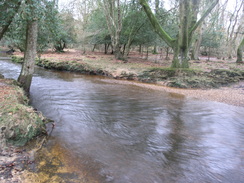
More sometimes-waterlogged paths took me roughly east towards a footbridge over a stream, and I followed the bank of this southeastwards. The walk through the trees was more bearable with water beside me, and after another footbridge the stream became Highland Water. This stretch was quite pleasant, although overgrown in places.
At Bolderford Bridge a track took me southwestwards to a road. By this time the sun was starting to fall, and I was greeted with red skies as I headed back along the roads into Brockenhurst. It was fairly dark by the time that I reached the station, having completed an enjoyable and mixed walk through the New Forest.
Directions
This walk starts off from Brockenhurst station. Leave the station and walk down the station approach and at the end turn right. If on the northern side of the station you will need to cross the level crossing southwards; after a few yards a road leads off to the left, ignore this, and a couple of yards further on turn left down Church Lane. This heads southeastwards, climbing uphill to reach a church where the road curves to the right. Opposite a farm turn left and follow a bridleway that heads southeastwards, entering some woodland before eventually meeting a track to the west of Roydon Manor. At the track turn right, and follow it as it heads westwards through the woods on Setley Common before reaching Setley Farm. At the farm ignore the road that leads off to the right, and continue on to reach the A337 road.
Cross this road and on the other side turn left for a couple of yards before turning right along another road. This heads northwestwards towards Latchmoor House and the curves to the left to head westwards to join the B3035 road. Continue west along this as it heads under a railway bridge, and when it curves to the left head straight on along a track. This heads westwards, passing under a railway bridge before reaching Cater's Cottage. Turn left here to join a cycle path that heads along the trackbed of an old railway line.
After a couple of miles the cycle path heads off to the left for a short distance to end at a road. Turn left down this road for a couple of hundred yards to cross over Wooton Bridge. Immediately on the other side of the bridge turn right, to follow Cycle Route 2 westwards through the Wooton Copse Inclosure. This winds to the right, left, and then left again before finally curving to the right to head westwards to meet the A35 at Holmsley Toll House.
Cross the A35, and on the other side head downhill along a road that heads to the northwest. After a third of a mile turning left to head southwestwards along a track, still following cycle path 2. It emerges from the trees and joins a track that is part of an old airfield. On the right is the Holmsey Caravan and Camp site; at the southern end of this the path turns to the right to head westwards, joining the access road that leads to the caravan site. This ends at Forest Road; turn right along this and follow it northwestwards for three-quarters of a mile until it ends at a crossroads at Cross Ways. Turn right to follow another road northwards across heathland; after a mile and a half it curves to the right to head northeastwards for two-thirds of a mile into Burley.
In the centre of the village turn right for a few yards and then right once more, to head eastwards along a road for a mile. When it reaches a junction with another road head straight on along another track for a third of a mile, and then take a footpath that heads northeastwards across heathland for a short distance to a road. Turn right along this road, and follow it as it curves to the left through Bisterne Close. After it settles on a westerly course turn right to join a footpath at SU232030, and follow this northeastwards across heathland to a footbridge called Rooks Bridge over Mill Lawn Brook.
From here take a series of footpaths that leads through the trees of Burley Old Inclosure, heading northeastwards from the bridge for a mile and a half to the A35 road. Turn left along the A35 to head northeastwards for a hundred yards as it crosses the Black Water on a bridge, and then turn right to head eastwards along a track for half a mile. At a T-junction in tracks, turn left to head northwards for three-quarters of a mile up brock Hill. Continue along the track as it curves to the right to head eastwards to reach the Rhinefield Ornamatal drive.
Cross the road and continue on along a track that heads eastwards before curving to the right. At the next junction (SU270055) turn left to join a track that heads northeastwards for a little over half a mile until it reaches a footbridge over a stream. Here turn right, and start following the northern bank of the stream southeastwards for two-thirds of a mile to another footbridge over the stream. Cross over the bridge, and continue on southeastwards along the southern bank of Highland Water. The path becomes hard to follow in places as it winds through the trees for a mile to reach Bolderford Bridge.
At the bridge turn right to head southwestwards along a track for half a mile until it ends at a road at Ober Corner. Head straight on along this road for half a mile, where it curves sharply to the left to head eastwards to end at another road. Turn left along this rad, and follow it eastwards as it passes Ober Farm and curves to the right to enter Brockenhurst. At SU297023 turn left to head eastwards along another road that heads eastwards through the town; crossing the B3055 and heading on to the A337. Here turn right for a few yard to reach the entrance to reach the level crossing, and then turn right to head towards the station entrance, where this walk ends.
Distances
| From | To | Distance (m) | Ascent (ft) | Descent (ft) |
|---|---|---|---|---|
| Brockenhurst station | Burley | 12.5 | 794 | 666 |
| Burley | Brockenhurst station | 11.0 | 299 | 427 |
This makes a total distance of miles, with 1093 feet of ascent and 1093 feet of descent.
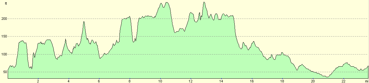
For more information on profiles, ascents and descents, see this page
Disclaimer
Please note that I take no responsibility for anything that may happen when following these directions. If you intend to follow this route, then please use the relevant maps and check the route out before you go out. As always when walking, use common sense and you should be fine.
If you find any information on any of these routes that is inaccurate, or you wish to add anything, then please email me.
All images on this site are © of the author. Any reproduction, retransmissions, or republication of all or part of any document found on this site is expressly prohibited, unless the author has explicitly granted its prior written consent to so reproduce, retransmit, or republish the material. All other rights reserved.
Although this site includes links providing convenient direct access to other Internet sites, I do not endorse, approve, certify or make warranties or representations as to the accuracy of the information on these sites.
And finally, enjoy your walking!
Nearby walks
| # | Title | Walk length (miles) |
|---|---|---|
| 309 | Fawley to Bucklers Hard | 15.4 |
| 310 | Bucklers Hard to Milford on Sea | 19.0 |
| 311 | Milford on Sea to Southbourne | 16.9 |
|
|

|