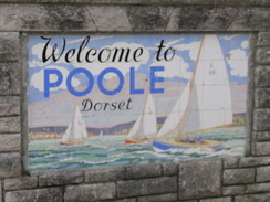
Walk #802: A walk from Christchurch to Poole
 |
 |
|
General Data
| Date Walked | 13/12/2007 |
| County | Dorset |
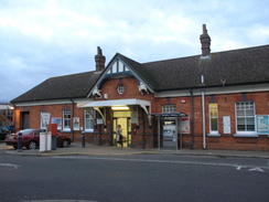
| Start Location | Christchurch station |
| End Location | Poole station |
| Start time | 08.00 |
| End time | 15.55 |
| Distance | 21.8 miles |
| Description | This was a very pleasant walk following the coast around from Christchurch to Poole, passing through Bournemouth. |
| Pack | Today I carried my 30-litre Karrimor rucksack, filled with waterproofs, a book and other odds and ends. |
| Condition | I felt absolutely fine after this walk. |
| Weather | The day was generally cloudy with occasional sunny periods. |
| OS map | Landranger number 195 (Bournemouth & Purbeck, Wimborne Minster & Ringwood) |
 |
 |
|
 |
 |
|
Map of the walk
Maps courtesy of Google Maps. Route for indicative purposes only, and may have been plotted after the walk. Please let me have comments on what you think of this new format. For a detailed table of timings for this walk, please see the table file.
 |
 |
|
 |
 |
|
Notes
I felt like doing another stretch of coastal walk today, so I drove down to park in Christchurch. The station was easy to find and the car park was hardly full, but when I tried to buy a parking ticket I found that the machine was not working. In the end I went into the ticket office to buy a ticket, and then headed back to the car to get ready.
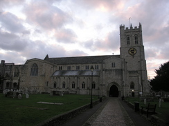
Christchurch was barely awake as I walked through it, and I nipped into a newsagents to buy some provisions before walking down to the Priory church, a very large structure that almost seems larger than Christchurch warrants. Roads and paths took me on to the bridge over the river, and immediately on the other side I turned to start following the southern bank of the river. In had walked this route on my coastwalk at the end of 2002, and the bridge was the first thing I remembered from that walk.
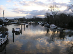
There were lots of boats moored in the river, but after passing a ferry landing the path started to head inland a little, the Priory often visible across the river to the north. A series of paths and tracks took me towards Wick Hams, and then on along the northern side of Hengistbury Head. There was a large building near the Hams that, I believe, stores the road train that operates here in summer.
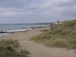
The ground became slightly marshy, but the path was almost always firm. The high land of Hengistbury Head was to my right as I joined the foreshore, and a couple of little footbridges over small tidal inlets were crossed before I turned to head north. This was an enjoyable little stretch of walk as I headed up to the land at the mouth of the entrance to Christchurch Harbour, passing a ferry landing on the way.
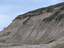
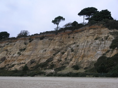
The water was rushing through the mouth of the harbour, which looked incredibly narrow, only twenty or thirty yards across, if that. I turned around and started heading south along the beach towards the headland, watching boats come to and fro. When I had set off I had been unsure if I could walk around the headland or over the top, which would depend on the tides. As it was fairly well out I decided to walk below the cliffs, which were fascinating to study - a soft stone with horizontal bands of harder rock in them.
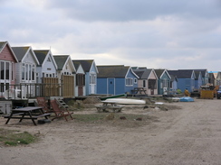
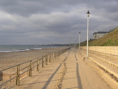
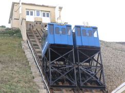
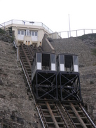
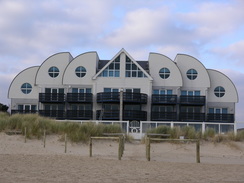
There was no problem getting around the headland, and I then followed the beach westwards. This was hards going in places on shingle, and it was a relief when a promenade started on the right. In Southbourne I passed a cliff railway heading up from the promenade, one of three that I would see today. As I headed westwards I started to see more and more people strolling along, although I can imagine that in summer it would be far more bustling.
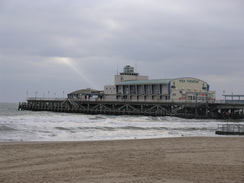
At one point there was a long linear building with cartoon figures on, a land-train building, and then I reached Boscombe Pier, which was under restoration. An artificial reef is to be built just off the coast here, and there were several signs stating how good and novel this was going to be, especially for surfers. I was unsure about how good it was going to be for non-surfers, but at least the pier was having work done on it.
Another cliff lift was reached before Bournemouth Pier was reached, and as on my previous walk I did not think much of Bournemouth itself. There were some pleasant buildings, architecture-wise, but it seemed to have been slightly spoilt by the commercialism, although nowhere near as badly as Scarborough. A short distance on at West Cliff was the third and final cliff railway, and from here the walk became more enjoyable for me.
I stopped off at the Durley Inn, which is right beside the promenade, for a drink and rest, and once I headed off again I felt utterly refreshed. The coast had been constantly turning to take a more southwesterly course, and as the beach was sandy I went down and walked through the surf line for a while. It was pleasant, but eventually I rejoined the promenade for the final stretch to the end of the promenade.
From Poole Head to Sandbanks I was passing in front of a series of very expensive houses (I read somewhere that Sandbanks has the most expensive houses in the country), and there was an information board showing how the sand spit (Sandbanks is literally banks of sand) had shrunk over the years. There had been work done to arrest and even reverse this process, but personally I would not risk having a primary home there.
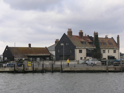
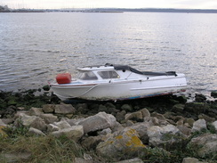
As the narrow entrance to Poole Harbour was reached the beach got narrower, until eventually I was forced to clamber over the rocks protecting the shore past a hotel, just as I had five years earlier. Fortunately this was not for too long, and I was soon at the landing for the chain ferry across to South Haven Point. Just on the other side of that harbour entrance was the start of the South West Coast Path, but this felt like a world away from that scenery. The chain ferry was quite interesting; the chain allows it to maintain its path against the swift currents that flow through the channel.
The foreshore at the northern side of the spit is barred to people, so I had to follow the road back, which was surprisingly filled with leaves at one point. I did try and follow a footpath to the foreshore near some pontoons, but had been forced to return to the road as the foreshore was blocked further east.
Eventually the road met the foreshore and followed it along, and this made for a long road plod with good views straight across the harbour. It would have continued in that vein for a few miles, but just before the road climbed up a hill away from the foreshore a short stretch of promenade continued north. I followed this along the foreshore for a short distance until it ended, when some steps lead back up to the road.
Fairly boring and uninteresting roads through the outskirts of Poole were interrupted by a phone call from a recruitment agency. It was a relief when, eventually, a path led off to the left, leading to Parkstone Bay and the water once more. The path headed around Parkstone Bay and I strolled around it in a relaxed manner, despite the fact that time was pressing. It then headed westwards into Poole, towards a large ferry that had just come in.
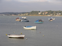
I remembered having liked Poole on my previous walk, and this trip confirmed that impression. I liked the small, narrow streets, the small and large boats in the marina, both working boats and leisure boats, and the things of interest that there were to see. There were also some intriguing buildings to look at.
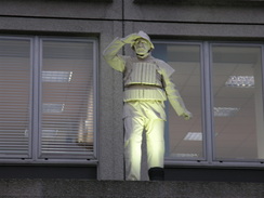
At the bridge over the Back Water Channel I turned right, heading up towards the station as it started to get dark. I passed the headquarters of Sunseeker, where luxury yachts are made, and then the RNLI HQ, which was complete with a large statue outside it. I knew that there was a train that I wanted to catch soon, so I forced myself onwards on tired legs, running across a busy main road to reach the station. Fortunately I just had time to buy a ticket back to Christchurch before the train came, and with it the last of the light departed. It had been a very pleasurable day's walk, although not exactly classic coastal walking. It is one that I can easily see myself doing again in the future.
 |
 |
|
 |
 |
|
Directions
This walks sets off from Christchurch station. Leave the station and at the entrance of the station approach turn left up the B3059 for a short distance until it ends at a T-junction with the B3073 Bargate. Turn right down this road and follow it southeastwards through Christchurch. At a roundabout continue straight on down High Street, and when this curves to the left continue straight on down Church Street towards the Priory.
Enter the priory grounds and head to the western side of the church and join Queens Avenue westwards. At the end of this turn left along a grassy area to join the riverside, and follow this westwards for a couple of hundred yards, then turn right to head north for a short distance until Willow Drive is reached. Turn left along this and follow it westwards until the B3059 is reached. Turn left along this road to cross a bridge over the River Stour.
On the other side of the bridge turn left to head eastwards along the southern bank of the river for 0.4 miles past a recreation ground. It skirts a road near a ferry landing, and then heads southeastwards along footpaths towards a Marine Training Centre at Wick Hams. Skirt past a car park, and join a track that heads eastwards. When this track curves to the right, continue straight on along a footpath that heads eastwards along the northern side of Hengistbury Head Nature Reserve, eventually joining the foreshore.
Continue along the foreshore as it crosses a couple of inlets on small plank bridges, and then curves to the left to head northwards. After a while join a road and continue northwards as the road passes a ferry landing. Continue on and round the headland at the narrow entrance to Christchurch Harbour, an then continue southwards with the sea on the left. As it approaches the large headland at Hengistbury Head you have a choice; if the tide is out you can walk along the foreshore around the south of the headland; if it is high you will have to climb up the steps onto the top and join the Stour Valley Way westwards. I stuck to the foreshore, and followed it westwards until a promenade was joined in Southbourne.
Follow this promenade westwards for over seven miles as it heads through Eastbourne until it ends at Poole Head. Here join the beach, and continue southwestwards through Sandbanks. As it approaches the mouth of Poole Harbour the beach becomes narrower, and I had to walk along the seawall past a hotel to reach the ferry landing at Sandbanks. Here turn right to head inland along the road for a few yards, and then turn left to head along the B3369 panorama Road. Initially this heads northwestwards before curving to the right to take a more easterly course. At a T-junction turn left to start heading northeastwards along the B3369 as it heads northeastwards, with Poole Harbour immediately on the left.
Continue along the B3369 as it curves to the left to start heading northwards along the eastern side of the harbour. As it curves inland slightly near a little pier a path leads off to the left, following the shoreline for a hundred yards before some steps lead back up to the road. Continue on along the B3369 road until turks Lane leads off to the left, carrying cycle route 2. Turn left along this and follow it southwestwards for a short distance until the cycle path leads off to the left, following the shoreline around the edge of Parkstone Bay.
Continue on paths and roads that skirt the shoreline and marina westwards through Poole until the B3068 is reached by the bridge of Back Water Channel. Here turn right along the B3068, and when this turns to the right after a short distance continue straight on along West Quay Road. This passes the RNLI headquarters and joins up with the A350. Continue straight on along this road, and use a crossing to gain access to Poole station.
 |
 |
|
 |
 |
|
Distances
| From | To | Distance (m) | Ascent (ft) | Descent (ft) |
|---|---|---|---|---|
| Christchurch station | Southbourne | 7.9 | 289 | 266 |
| Southbourne | West Cliff | 4.2 | 394 | 394 |
| West Cliff | Poole Head | 2.3 | 85 | 112 |
| Poole Head | Poole station | 7.4 | 184 | 184 |
This makes a total distance of 21.8 miles, with 952 feet of ascent and 956 feet of descent.
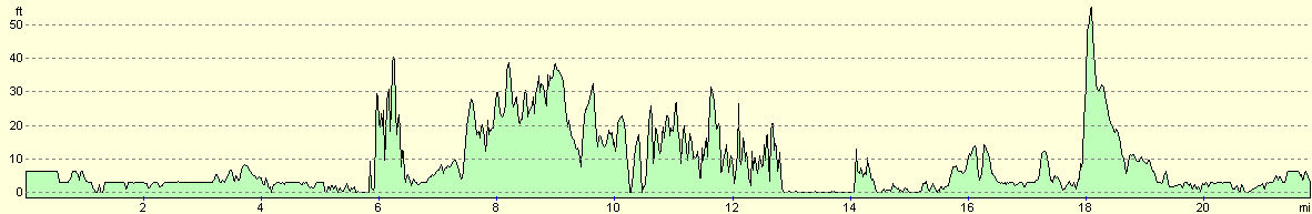
For more information on profiles, ascents and descents, see this page
Transport
There are regular (usually hourly) train services between Christchurch and Poole.
 |
 |
|
 |
Disclaimer
Please note that I take no responsibility for anything that may happen when following these directions. If you intend to follow this route, then please use the relevant maps and check the route out before you go out. As always when walking, use common sense and you should be fine.
If you find any information on any of these routes that is inaccurate, or you wish to add anything, then please email me.
All images on this site are © of the author. Any reproduction, retransmissions, or republication of all or part of any document found on this site is expressly prohibited, unless the author has explicitly granted its prior written consent to so reproduce, retransmit, or republish the material. All other rights reserved.
Although this site includes links providing convenient direct access to other Internet sites, I do not endorse, approve, certify or make warranties or representations as to the accuracy of the information on these sites.
And finally, enjoy your walking!
Nearby walks
| # | Title | Walk length (miles) |
|---|---|---|
| 311 | Milford on Sea to Southbourne | 16.9 |
| 312 | Southbourne to Hamworthy Station | 15.3 |
| 313 | Hamworthy Station to South Haven Point | 18.0 |
|
|

|