Walk #625: A circular walk from Southam
 |
 |
|
General Data
| Date Walked | 22/08/2004 |
| County | Warwickshire |
| Start Location | Southam |
| End Location | Southam |
| Start time | 08.31 |
| End time | 16.34 |
| Distance | 22.2 miles |
| Description | This was a nice, relaxing walk, taking in part of the Oxford Canal and rural footpaths. |
| Pack | Today I carried my 30-litre Karrimor HotRock rucksack, which was filled with water bottles, my waterproofs, a fleece and various electronic gadgets. |
| Condition | I has a relatively untroubled day, the only exception being the problem with the underside of my left foot, which ached quite severely at times. Fortunately these periods were infrequent, although for the last quarter of the walk it gave a dull throbbing ache. Aside from this I could have walked further, as I had plenty of energy left in my legs and no other part of my body was giving me problems. |
| Weather | Today started off quite bright, with only a thin sheen of clouds occasionally blocking out the sun. It was quite a warm day, and although the clouds slowly thickened as the day progressed until there was some ominous grey ones overhead, it never threatened to rained. |
| OS map | Landranger number 151 (Stratford-upon-Avon, Warwick & Banbury) |
 |
 |
|
 |
 |
|
Map of the walk
Maps courtesy of Google Maps. Route for indicative purposes only, and may have been plotted after the walk. Please let me have comments on what you think of this new format. For a detailed table of timings for this walk, please see the table file.
 |
 |
|
 |
Notes
Towards the end of last year I did a sixteen mile stroll northwards from Oxford along the Oxford Canal, and as this canal links up at its northern end with the Grand Union Canal, which I have walker previously, it seemed like an ideal route to walk. Unfortunately whilst I can do the next 12-mile stretch from Lower Heyford to Banbury in the south and use trains to get back, at the northern end of the canal public transport gets much more complex. For this reason I decided to do the northern section of the canal from Napton Junction in a series of circular walks, and so bleary-eyes I set off this morning on the ninety-minute drive to Warwickshire. The journey was reasonably good and enhanced by six balloons from the Northampton Balloon Festival hovering over the town, although I did manage to 'lose' the A45(T) if between Northampton and the M1 and ended up driving along country lanes to reach Daventry.
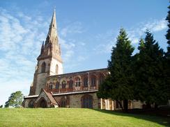
Despite this diversion I reached Southam and the start of the walk before eight thirty in the morning, which was pleasingly early after the long drive. Fortunately there is a free car park in the town and this was nicely close to the centre. The day looked like it was going to be very nice and ideal for walking, and so I threw on my rucksack, locked the car and set off on the walk. The town was very quiet at this time of the morning, and I was more or less on my own as I walked up to the superb St James's Church (founded in 1294) and took some photographs of it from various angles. The town was the site of a civil war skirmish in 1642, and King Charles used what is now the chemists shop as a royal mint! A little further on from the church I met a man with a shopping trolley waiting patiently outside the Budgens supermarket in the town; unfortunately he was in for a long wait as the Sunday trading laws meant that the supermarket was not due to open for another hour and a half!
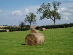
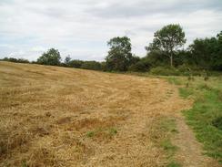
A short stretch of road walking took me south to the A425 road, and once across this a footpath led me past a cricket ground and on southwards. There were a few false paths on the ground, and these soon led me too far to the west towards some large factory units. I realise this mistake, but I really did not want to turn back to find the correct path, and so I followed field boundaries southwards until I reached the end of a track to the west of Starbold Farm. The track allowed me to gain access to the footpath proper at the farm, and from here it was much easier to follow, especially as the farmers had cleared the route through the fields. I also discovered that this section of path is part of the Blue Lias Ring, a series of circular walks in Warwickshire.
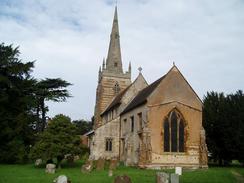
The path passed through the churchyard of the pretty All Saints Church in Ladbroke, which I took a few photographs of but did not enter I had too far to walk to spend time exploring churches. A few hundred yards of road walking led me to the start of another footpath, which was easy to follow as it headed southwestwards past the northern flank of Weddington Hill. Just before the railway line was reached I joined a bridleway that headed south for about half a kilometre before ending at a road. This road headed south for a couple of miles, passing a bridge under a railway line before eventually reaching the farm at Manor House. When I reached the farm I could not see any obvious route into the field and there were some people standing around, so instead of climbing the gate I thought that I would ask. One of the men turned out to be the farmer who owned the land (as I suspected from his clothes), and we ended up chatting for a while. He gave me directions across the land which were extremely concise and accurate, and after talking about the local farming conditions I bade him goodbye and set off across the field.
The next stretch of footpaths were more interesting than the road, but still fairly nondescript; the path passed under a railway line before heading on to meet the A423(T) road near Manor Farm. I then had to walk south for a little under a kilometre along the main road, and unfortunately there was no pavement to speed me on my way. The traffic was not too busy and I just stepped onto the wide verge whenever a car came towards me, but this did impede my progress slightly. I was quite relieved when the road section came to an end and I diverted off to down a driveway that led to Bridge 131 on the Oxford Canal. There was no obvious way down from the bridge onto the canal towpath so I went down into the neighbouring field and climbed over a fenced gap in the hedge to access the towpath.
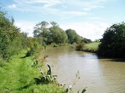
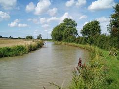
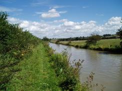
The Oxford Canal is a contour-hugging canal, choosing to minimise the number of locks by keeping the same height for long distances. For this reason the canal has quite a winding route, and this was the reason that for the first two miles I was heading eastwards instead of northwards. The canal was very busy, but all the boats seemed to be coming towards me; I encountered no boats coming from behind me. This was not as surprising as it should have been, as my walking pace is more or less the same as the speed limit on canals, and so the chances of my catching up (or being caught up with) away from locks is quite low. For more information on the Oxford Canal please see Jim Shead's excellent canal website.
The canal initially skirted the northern side of Wormleighton Hill, with a large transmission mast in the field to the north, before winding around in a rough easterly direction. There was not much of note on this stretch of walk, with no locks, although canal side walking is rarely boring and there was plenty to look at as I walked along. When I reached Bridge 126, which is situated where the canal finally leaves its easterly course and turns north, I decided to sit down and have a rest. I found a nice place to sit in the sun by the bridge, and was busy devouring a Snickers bar when a cyclist emerging from under the bridge startled me. I took this as a sign that I should really be getting a move on, and so I put my rucksack back on and headed off along the canal.
I found the next few miles of walk along the towpath northwards towards Marston Doles, passing but never seeing the village of Priors Hardwick, went quite fast, and I was surprised when I suddenly came across the lock that lies right next to the road bridge. It was a nice scene, and I continued on along the towpath in high spirits. Whereas before Marston Doles there had been few locks, now there was a multitude of them, in the forms of the Napton Locks. These take the canal down to meet the Grand Union Canal at Napton Junction, and they certainly helped to break up my walk slightly. I passed one canal side pub by bridge 112, but I ignored it and continued on for another mile until I reached the Bridge at Napton pub, beside the A425 road.
I went into the pub and after a slight wait I got served. There were some nice real ales on sale, but I chose instead to have a pint of orange and lemonade as I thought that it would be more refreshing, and this turned out to be a good choice. I gulped down this pint at a ferocious rate, and another swiftly followed it; as my thirst had been quenched by the first pint I could take more time in drinking the second one. Eventually I realised that I had to get on with the walk, and so I left the pub and set off for the walk to Napton Junction with the Grand Union Canal, only one mile away. I reached this quite quickly, and then proceeded northwards along the Grand Union Canal towards Calcutt Locks. These were a hive if activity with several boats queuing up to go through, The difference in size between the narrow locks of the Oxford Canal and the broad locks of the Grand Union was quite telling; at these locks two narrow boats could fit in at a time.
From Calcutt Locks the canal took a northeasterly course for a mile, passing the abutments of an old railway bridge over the canal, which was solely being torn down and the bricks reclaimed. I was surprised by the thickness of the wall, which was nine or ten bricks thick; sometimes I find it amazing what sort of things interest me when I am on a walk! A little further on I came across a bridge that allowed me to cross the canal, an there followed a little green lane that climbed to cross the course of the old railway line on a filled-in bridge, before descending to meet fields. There was a dead sheep beside this stretch of path, and the smell was more than a little nauseating and I was glad to get out of range of the smell.
After the long walk along the canal I found the bridleway that took me back towards Southam and the end of the walk to be fairly uninteresting, and the spire of Southam church that was visible in the distance never seemed to grow any bigger. I put my Walkman on and just walked, and before I knew it I found myself on the A425 road on the eastern outskirts of the town. When I finally got back to the car I could look back on what had been an enjoyable walk, and, apart from the ache in my left foot which has been a companion on the last few walks that I have done, I felt fine.
Directions
This walk sets off from the free long-stay car park in Wood Street, in the centre of Southam. Leave the car park and turn right, to walk a few yards up Wood Street until it ends at a T-junction with the High Street. Turn left along the High Street, and follow it as it heads towards the church, skirting the building before turning to the left and passing a Budgens superstore before joining Banbury Road. Follow Banbury Road southwards for a few hundred metres until it ends at a junction with the A425 road.
Cross the A425 road and then turn right for a few metres before turning left to follow a footpath along the edge of a cricket ground. It emerges out into a field at the southern end of the ground, and the path then continues on southwards. I cannot give very good descriptions for this part of the walk as I went quite wrong as I followed some obvious paths on the ground that led southwestwards instead of southwards; take car and try to ensure that the course that you take is more southerly. The path eventually skirts immediately to the west of Starbold Farm, and from here it is much easier to follow as it heads in a rough southerly direction across fields. As it nears Manor Farm the path turns slightly to the left, to head southeastwards towards Ladbroke Church.
The path skirts the outside of the churchyard before entering it and crossing to the main gateway leading to the church. Once on the road outside the church, turn right to walk westwards out of the village for a couple of hundred yards until a footpath leads off to the left. Turn left and take this footpath, which is easy to follow as it heads southwestwards, passing immediately to the north of the flank of Weddington Hill. The path skirts the northern edge of a small patch of woodland, and a few yards after the woodland edge it crosses a stile and reaches a junction with a bridleway. Turn left to join the bridleway and follow it as it heads south for about half a kilometre until it ends at a minor road.
Once at the road turn left and start following it as it heads southwards for a couple of miles; it passes under a railway bridge and passes a farm at Holmes House. When a little road junction is reached ignore the road that leads off to the right but continue onwards until Manor House Farm is reached on the right. Just slightly beyond the farm a footpath leads off to the left, heading diagonally across a field, heading just to the right of a building called the Hovel in the distance. The footpath passes through a gate to the right of the Hovel, before following a hedge to a bridge under a railway line. After passing under the bridge the path becomes slightly less easy to follow; it basically heads to the north of Watergall Fox Covert and over the summit of a low hill before turning to head northeastwards and joining a track at Manor Farm.
Follow the track as it heads northeastwards for a couple of hundred yards until it ends at a T-junction with the A423(T) road. Turn right and follow the A423(T) southwards for a little under a kilometre; there is no pavement beside the road so care is needed, but the verge is wide and easy to walk along when traffic comes.
On a slight right-hand bend turn left and walk up a little track that leads on for about fifty yards to a bridge over the canal. There is no access to the canal towpath from the bridge, so go into the field to the left and follow it to the bridge, where there is a fence that can be climbed over to access the towpath. Once on the towpath turn to the left and start following it eastwards; after a couple of miles the canal turns to head northwards.
After about eight and a half miles on the towpath the Oxford Canal meets the Grand Union Canal at Napton Junction. Here cross the footbridge over the Grand Union Canal, and once on the other side of the bridge turn right to pass under it and head northwards along the canal. After a kilometre the flight of three locks at Calcutt are reached; after the bottom lock the canal turns to the left slightly to head northwestwards. Another kilometre further on a narrow bridge over the canal is reached; leave the towpath and cross this bridge to join a bridleway that initially follows a narrow green lane before going into a field.
The bridleway is easy to follow as it crosses a road and heads on southwestwards to another. Cross this road, and then continue on along the bridleway as it passes across many fields. After about a kilometre the bridleway takes a more westerly heading, with the church spire of Southam Church visible directly ahead. Eventually the bridleway meets a track; turn left down this track for a few yards until it reaches the A425 road on the eastern outskirts of Southam. Turn right and walk a few yards to a roundabout with the A425 and A4523(T) roads; head straight across this roundabout and follow Daventry Road towards the centre of Southam. When the road curves to the left turn right up Wood Street, and then almost immediately turn right up into Wood Street car park, where this walk ends.
Distances
| From | To | Distance (m) | Ascent (ft) | Descent (ft) |
|---|---|---|---|---|
| Southam | Ladbroke | 2.2 | 79 | 74 |
| Ladbroke Church | Bridge 131, Oxford Canal | 5.8 | 315 | 248 |
| Bridge 131, Oxford Canal | Napton Junction | 9.3 | 220 | 261 |
| Napton Junction | Southam | 4.4 | 89 | 120 |
This makes a total distance of 21.7 miles, with 703 feet of ascent and 703 feet of descent.
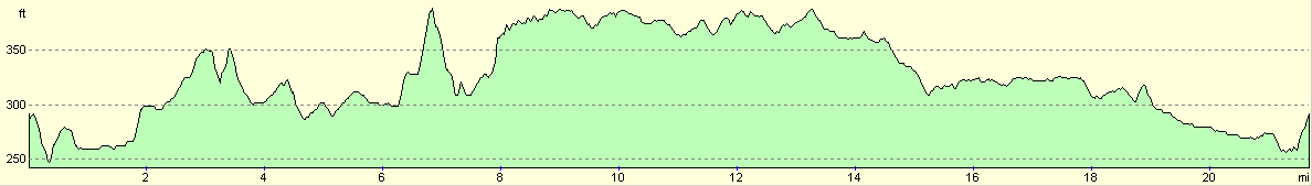
For more information on profiles, ascents and descents, see this page
Disclaimer
Please note that I take no responsibility for anything that may happen when following these directions. If you intend to follow this route, then please use the relevant maps and check the route out before you go out. As always when walking, use common sense and you should be fine.
If you find any information on any of these routes that is inaccurate, or you wish to add anything, then please email me.
All images on this site are © of the author. Any reproduction, retransmissions, or republication of all or part of any document found on this site is expressly prohibited, unless the author has explicitly granted its prior written consent to so reproduce, retransmit, or republish the material. All other rights reserved.
Although this site includes links providing convenient direct access to other Internet sites, I do not endorse, approve, certify or make warranties or representations as to the accuracy of the information on these sites.
And finally, enjoy your walking!
Nearby walks
| # | Title | Walk length (miles) |
|---|---|---|
| 158 | Bugbrooke to Braunston | 15.1 |
| 162 | Braunston to Leamington Spa | 16.6 |
| 598 | A circular walk from Badby via Lower Shuckburgh | 21.4 |
|
|

|