Walk #624: South Stack to Carreglefn
 |
 |
|
General Data
| Date Walked | 15/08/2004 |
| County | Anglesey |
| Start Location | South Stack |
| End Location | Carreglefn |
| Start time | 09.09 |
| End time | 16.17 |
| Distance | 17.2 miles |
| Description | This was a walk of two halves; a superb walk over Holyhead Mountain was followed by a long and fairly uninteresting road walk. |
| Pack | Today I carried my 30-litre Karrimor HotRock rucksack, which was filled with water bottles, my waterproofs, a fleece and various electronic gadgets. |
| Condition | I have had some trouble today with the underside of my left foot, which was aching so much that for a period I was limping. This was also the case when I did a short walk yesterday, so it is not something that has happened today. Aside from this I feel fine, and with a little rest I could easily have walked further. |
| Weather | The day started off as mixture if sunshine and cloud, but as we approached Holyhead Mountain I could see that the top was wreathed in cloud. This meant that when I was at the summit I was in cloud, although a short distance down from the summit I came out into sunshine. The rest of the day was a mixture of bright sunshine and thin cloud, although there was about five minutes of rain, which was so light that I did not bother to put my coat on. |
| OS map | Landranger number 114 (Anglesey) |
 |
 |
|
 |
 |
|
Map of the walk
Maps courtesy of Google Maps. Route for indicative purposes only, and may have been plotted after the walk. Please let me have comments on what you think of this new format. For a detailed table of timings for this walk, please see the table file.
 |
Notes
An extended three-day weekend led myself and Sam up to Anglesey for the weekend, and this was very pleasing as it meant that I would get the opportunity to walk up to the summit of Holyhead mountain, the highest point in Anglesey and therefore a county top that I have to walk. Annoyingly on my coastal walk I walked around the western and northern sides of the mountain, but did not realise that it was a county top and therefore did not divert off to climb it. I passed within a few hundred metre of the summit (although also a fair way below it) on my way to North Stack, and it was therefore quite disappointing to realise when I got back that I had missed the summit by such a small distance.
This trip was a good opportunity to finally get to the summit, however, and so a little negotiation with Sam allowed me to free up the Sunday so that I could do the walk. The day dawned and when I emerged from my tent at the campsite we were staying at near Moelfre I was greeted with a layer of cloud with occasional glimpses of the sun. Sam made me some delicious bacon and egg sandwiches for lunch, and once my appetite was well and truly sated we set off on the surprisingly long drive to South Stack, right on the western extremity of Anglesey. As we travelled along the narrow roads and finally the broad and fast A55(T) the clouds parted and more sunshine became visible, which put me in an even more optimistic mood for the day. Unfortunately as we reached the centre of Holyhead and got my first glimpses of the mountain my enthusiasm was diminished somewhat by the sight of cloud laying in a blanket over the summit of the mountain, with blue sky all around.
Road diversions in the centre of the town of Holyhead made it non-trivial to find the road that led to South Stack, but after some examination of the map and one reversal we finally got on the winding roads that led across the remainder of Holyhead. Eventually we reached the destination, and Sam pulled up in the car park next to the visitors centre and I finally got out to stretch my legs; the journey had taken much longer than I had expected, and my legs had seized up on the drive. It was then that we realised my first mistake of the day; I had left my phone in the tent, and so I had to take Sam's mobile and we arranged a rather convoluted system about where to meet up in the centre of Holyhead. With these formalities out of the way I kissed Sam goodbye, put my rucksack on and set off, ignoring the extreme temptation of a bacon buttie from the cafe.
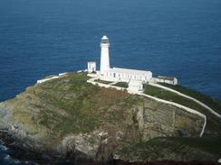
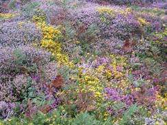
I left the car park and followed the short stretch of road that led towards South Stack Lighthouse, passing Ellin's Tower on the way. On my coastal walk I had been massively impressed with South Stack lighthouse, and I remembered it as one of the more spectacular lighthouses that I passed. Seeing it again reinforced the memory; looking down at the lighthouse from the end of the road above was a superb sight, and I lingered around and took photographs from various angles. Eventually I could not postpone any longer, and so I had to choose which route I had to take for the first mile or so. Last time I had taken the Anglesey coastal path that wound around the cliffs near the coast, but this time I decided to take a different route that followed a track towards the masts at the base of the mountain. This was easy going, and I found myself loving the many, varied colours of the plants that bordered the track. Green, purple, red and yellow could be seen in abundance, and it was a lovely sight, even if the cloud that was visible at the top of the mountain was clearly visible.
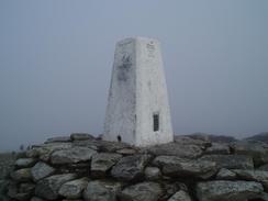
Near the masts I met the Anglesey Coastal Path that I had walked previously and left the track. A few hundred yards later the coastal path diverged off to the left at a Y-junction, and I headed on along the right-hand branch. This soon left to some rough stone steps that leaded up the hill. A short distance up these steps I entered the cloud layer, and when the steps ended I used some vague paths and my compass to direct me up the hill, and I must admit that I was quite relieved to reach and see the trig pillar. I paused at the pillar for a few minutes, annoyed by the fact that what should have been great views were spoilt by the low cloud, and photographed the pillar from various directions, although how well these will turn out in the cloud I do not know. Eventually I managed to tear myself away and started the descent down the hill.
Seemingly within a few yards I emerged out of the clouds, and I started walking along indistinct paths that led southeastwards down the mountain. The rocky terrain that lay beside the path looked superb in the sunlight, and I could see a couple of ships out to sea near the breakwater of Holyhead Harbour. I really enjoyed the descent, and as the gradient slackened and I joined a narrow green lane, trapped between two low stone walls, I realised that the best bit of the walk was over far too quickly. The lane ended at a road in the hamlet of Mountain, and I followed it downhill to a larger road in Llaingoch. I was feeling fit and I was behind schedule to meet Sam, so I started yomping down the road towards the centre of Holyhead.
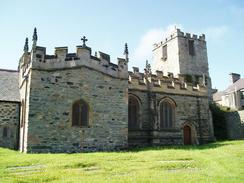
When I started the descent down into the centre of the town I was faced with a problem; Sam and I had not accurately arranged a place to meet, and so I started going into every car park I could find off the road to see if I could find her. In the last of these I came across a surprise - the walls of a third-century three-walled Roman Fort, inside which was St Cybi's church. I had not expected there to be a Roman fort in the town, or for the walls to be quite so prominent. I explored for a while, and when looking through a gate in the wall I saw Sam parked on the main road near to the railway station. I could not get through the gate, so I had to walk back to the road and then descend down to the car. I met Sam, who was chatting to a couple who were planning to walk up the Mountain, and I told them of the route that I had taken up and down. I really did not want to linger, so I said goodbye to Sam and then headed off down the road towards the station.
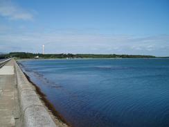
At the bridge over the railway line beside the station I stopped to write down my position in a book, but I found that my pen did not work. Annoyed, I saw that there was a newsagents a short distance away so I diverted to it and bought a few pens. On my previous walk I had left Holyhead using the coastal path, but as I did not really want to replicate my route this time I decided to walk along the A5 instead. Although this allowed me to have a different route and better views of the massive aluminium works that dominate the town, it was nowhere near as nice as the coastal walk, and as there was no pavement I had to walk along the verge for a long way. I was relieved when I reached the western end of the Stanley Embankment, a 1.2km long embankment completed by Thomas Telford in 1823. This links Holyhead to the main island of Anglesey, and beside it are a bank carrying the railway line and also the new bridge carrying the A55(T) onto Holyhead.
I enjoyed the views out to sea from the embankment (and indeed of a Chinook helicopter that passed directly overhead on its way to RAF Valley), and once it ended I was forced to walk along the road towards the village of Valley; fortunately there was a pavement beside the road. This led me to another quieter road, which headed northeastwards through Newlands Park and on to the A5025 road I carefully followed this northwards for about a mile into the village of Llanfachraeth, and as I was feeling like a rest I nipped into the Gwesty Holland Hotel in the village. I was surprised to see that the television was on the F1 grand prix, so I ordered a lovely pint of J.W. Lees and sat down to sup it as I waited for the race to start. Another pint eventually followed, and as the race progressed I started chatting to one of the locals who was also engrossed in the race. The race was quite boring, and so after I had been in the pub for an hour I said goodbye, got up and set off on the rest of the walk, with my body much refreshed by the walk.
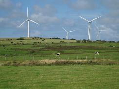
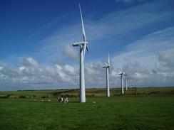
A long road walk then followed eastwards, the only exception being a little diversion along a footpath to visit the Graianfryn trig point. The road passed near to the attractive Llynnon windmill before entering Llanddeussant, and I then headed on northeastwards along the road towards a set of 34 large wind turbines on a nearby hillside. I started to find all this road walking fairly boring, and with no real target set for the day I started to wonder how far I really wanted to walk. I phoned Sam up and arranged for her to meet me in an hour at Carreglefn, and this set target gave me more motivation and I increased my pace along the road. Although the massed ranks of turbines were initially fascinating the interest soon waned, and I soon found myself in Llanbabo, with glimpses of the Llyn Alaw reservoir visible in the valley to the right. The end of the walk was now only a couple of miles away and so I followed the road northwards, passing very close to four wind turbines, the noise of which were quite distinctive.
There was one last thing that I wanted to do before the end of the walk, and that was to visit the Llanol trig point. This had been visible for some time near a little covered reservoir, and it was quite easy to access along the edge of a field. Unfortunately the pillar itself was on a steep-sided overgrown bank, and it took me a little time plus some nettle stings to get up to it so that I could read the flush bracket. This having been done, I returned to the road and walked along it to into Carreglefn, where Sam was waiting for me. I still felt fit and so we drove on to Parys Mountain, an old and spectacular copper mine, which I walked around for a while; this is well worth a visit.
Directions
This walk starts off at the end of the public road directly above South Stack lighthouse on Anglesey. There is a convenient car park a hundred yards further down the road, next to the RSPB visitor's centre near Ellin's Tower. From the lighthouse you have two choices for the first kilometre; you can either follow the Anglesey Coastal Path, or you could do what I did and follow the road downhill towards the car park for about fifty yards, and then turn left along a narrow surfaced track. The track heads in a rough northeasterly direction over the moorland to a building by a transmission mast. Continue on along a rough track that leads to a series of radar dishes on the edge of the cliffs. Pass on the inland side of these, and when the path reaches a fork take the right-hand one, which heads northeastwards to the base of the cliffs. Some steps lead up the hill, and when these end turn slightly to the right and carefully follow a path eastwards to the trig point that marks the summit of Holyhead Mountain.
From the summit take a path that heads eastwards off the mountain; be careful as there appeared to be several different paths that leads off the summit, and as it is a rock climbing area many of these may at the end of steep drops. When the gradient slackens a narrow path is met coming in from the left; turn right along this path and follow it as it heads southeastwards, slowly losing height as it does so. The path enters a green lane between two low walls, and this eventually emerges onto a road in the hamlet of Mountain. Turn right and follow the road downhill, and when another junction is reached turn right and follow this road until it meets a larger road in Mountain. At this road turn left, and follow it as it heads eastwards through Llaingoch Pont Hwfs. This village merges into Holyhead; simply continue straight on as the road starts to drop downhill; when the road ends at a T-junction turn right and follow the road as it curves around, eventually reaching sea level at the A5154 road in the centre of Holyhead.
Once at the A5154 road turn right and follow it southwards past the station; continue along the road as it starts to rise up to a bridge over the railway line, and then turn to the left to cross over onto the eastern side of the line. Immediately on the other side of the bridge turn right and start following the A5 as it heads southeastwards; after about a kilometre a roundabout with the A5153 reached. At the roundabout turn half-left and continue along the A5 as it initially heads eastwards past an aluminium works, before curving to head southeastwards before eventually meeting the western end of the Stanley Embankment beside Beddmanarch Bay. Continue on along the A5 as it crosses the embankment and then on into the village of Valley. Take the first road that leads to the left northwards through the village before turning to the right and heading eastwards for a couple of kilometre until it ends at a T-junction with the A5025 road. At the A5025 turn left and head north for a mile along the road until it approaches the village of Llanfachraeth.
Walk through the village until the Gwesty Holland Hotel is reached on the left; here turn right along a minor road that heads northeastwards out of the village. After about a mile the road curves onto a more easterly heading, and shortly after it does so turn left along a footpath that heads northwards, initially along a green lane for a hundred yards before heading directly up the hill. The path crosses a hedge using a stile, and once on the other side turn right and follow the hedge as it heads northwards for a hundred yards past a trig point to a road. Turn right and follow this road eastwards as it heads down a slight hill and ends at a road junction. Turn left and follow this road as it heads northwards for a hundred yards before curving to take a more northeasterly course.
Continue along the road for three and a half miles until the hamlet of Llanbabo is reached. Here turn to the left and follow a road that heads northwards, passing immediately to the left of four wind turbines to a crossroads. From here I went to visit a trig point close by to the left next to a covered water reservoir; if you do not want to visit the pillar then continue straight on at the crossroads for about a kilometre to reach the village of Carreglefn. This walk ends at a road junction in the village, immediately to the north of the chapel.
Distances
| From | To | Distance (m) | Ascent (ft) | Descent (ft) |
|---|---|---|---|---|
| South Stack | Holyhead | 3.3 | 459 | 778 |
| Holyhead | Llanfachraeth | 6.4 | 210 | 190 |
| Llanfachraeth | Carreglefn | 7.5 | 548 | 331 |
This makes a total distance of 17.2 miles, with 1217 feet of ascent and 1299 feet of descent.
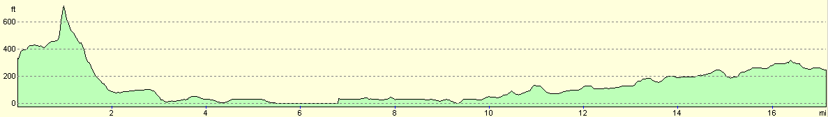
For more information on profiles, ascents and descents, see this page
Disclaimer
Please note that I take no responsibility for anything that may happen when following these directions. If you intend to follow this route, then please use the relevant maps and check the route out before you go out. As always when walking, use common sense and you should be fine.
If you find any information on any of these routes that is inaccurate, or you wish to add anything, then please email me.
All images on this site are © of the author. Any reproduction, retransmissions, or republication of all or part of any document found on this site is expressly prohibited, unless the author has explicitly granted its prior written consent to so reproduce, retransmit, or republish the material. All other rights reserved.
Although this site includes links providing convenient direct access to other Internet sites, I do not endorse, approve, certify or make warranties or representations as to the accuracy of the information on these sites.
And finally, enjoy your walking!
Nearby walks
| # | Title | Walk length (miles) |
|---|---|---|
| 408 | Aberffraw to Trearddur | 19.3 |
| 409 | Trearddu to Llanfachaeth | 19.0 |
| 410 | Llanfachraeth to Cemaes | 18.2 |
|
|

|