Walk #408: Aberffraw to Trearddur
 |
 |
|
General Data
| Date Walked | 08/04/2003 |
| County | Anglesey |
| Start Location | Aberffraw |
| End Location | Trearddur |
| Start time | 08.28 |
| End time | 16.44 |
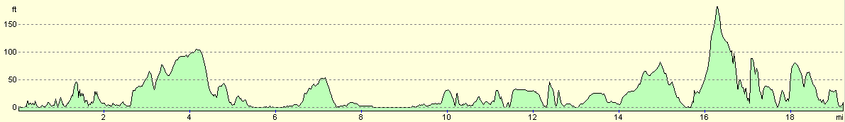
| Distance | 19.3 miles |
| Description | This was quite an enjoyable day on Anglesey and Holy Island, although it was let down by the poor quality of the footpaths. |
| Pack | For most of the day I carried my 30-litre Karrimor HotRock rucksack, which was filled with my packed lunch, waterproof leggings, water bottle and a couple of spare shirts, together with the usual assortment of odds and ends. For the last few miles from Rhoscolyn I took my pack off, as I did not really need any of the things in it for that last section. |
| Condition | I had a couple of little problems; firstly for the first five or so miles my left knee was hurting, and then towards the end of the walk my right ankle hurt. Despite this I did quite well, and I did not tire myself out too much. |
| Weather | Last night was the coldest for some time, and it took some time for Mervan to warm up in the morning. The day was quite sunny but it never actually got what I would describe as warm, mainly because of the wind, which was not too strong but it was cold. There were very few clouds in the sky at any time of the day, and there was no sign of any rain. |
| OS map | Landranger number 114 (Anglesey) |
 |
 |
|
 |
 |
|
Map of the walk
Maps courtesy of Google Maps. Route for indicative purposes only, and may have been plotted after the walk. Please let me have comments on what you think of this new format. For a detailed table of timings for this walk, please see the table file.
 |
Notes
As I was getting ready to set off today we got disturbed by a man who drove up in a Land Rover and told us off for sleeping overnight in the car park. He pointed to a sign prohibiting overnight parking that was so faded it was virtually white and very unreadable, particularly from a distance. It was also stuck below another sign, which made it look rather unofficial. This is the first time that we have been caught parking overnight in a place that we should not, and I sadly must say that I expect this to happen more often as summer comes along.
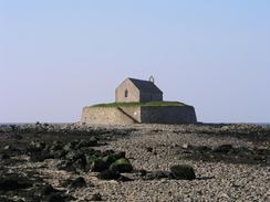
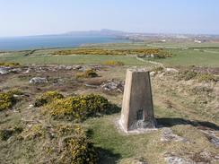
Between Aberffraw and Rhosneigr I passed two interesting structures - the first of which was the Church of Sy Cwyfan, which is situated on a little islet between Porth Cwyfan and Porth China that is linked to the mainland by a causeway that is covered at high tide. The church was originally built in the seventh century and was rebuilt in 1893. A nice story about this church is that when it was in regular use for services if the tide came in quicker than expected the congregation would make a dash for the door to get back to the mainland! The other interesting structure is the Barclodiad y Gawres, a Neolithic burial chamber between 3,900 and 4,500 years old. I have seen the remains of several Neolithic burial chambers on this walk (particularly in the Pembrokeshire area) but this one is very unusual, as it has been rebuilt. From the site that I approached it I could only see a low mound on top of the hill, and when I climbed to the top I found a small concrete cap on top of it. When I went around the other side, however, I found the entrance passageway. This leads into the centre of the chamber and allows you to see the interior the way it would have been. I could not go all the way in, however, as the gates were locked, but I did manage to get a good view of it nonetheless.
The walk around RAF Valley was fascinating, and I enjoyed watching the planes fly overhead. Most of them were black Hawks, training aircraft that are also used by the Red Arrows. A whole series took off and landed as I walked past the airfield, and some of them appeared to be doing touch-and-goes or low passes over the airfield. At the approach to the airfield there were quite a few plane spotters, looking through binoculars or cameras at the airfield, and I myself managed to get a nice couple of photographs of planes going overhead. At one stage a much larger fighter-bomber came in to land, although I cannot tell what sort it was. RAF valley is also the base of a helicopter squadron, and there were several of these flying around the place as I walked past. After seeing so many quiet or deserted airfields on this walk, I was glad to see a bustling one for a change.
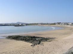
Sam had arranged for me to meet a photographer from an Anglesey and Holyhead newspaper by the beach in Rhoscolyn, and I set off this morning believing that I had given myself enough time to meet them at two in the afternoon. I was on schedule by the time I reached Rhosneigr, but after this I found that I slowed down considerably due to the poor state of the footpaths. I was trying to follow the new Anglesey Coastal Path, but unfortunately the new permissive footpaths in this area were not well marked. In one place a new signpost pointed into totally the wrong field, and in others I could not find the way out of fields. This was all very annoying, and by the time that I reached Four Mile Bridge I was behind schedule. I therefore made a decision to walk south along the road to Rhoscolyn rather than take the looping paths to the east. Walking along the road allowed me to speed up, and I arrived at the beach five minutes late, and only a minute after the journalists. I then had a quick interview and quite a long photo shoot that was quite enjoyable. After the photo shoot I had a phone call from BBC radio Cambridge, so I walked along the beach with my boots off whilst I did a radio interview. This was all good fun, and I must admit that I am becoming more at ease with dealing with the press. A little note that I could make; when I was walking along the footpath at the northwestern end of Valley Airfield I saw that the tide was out, and that the section of the inland sea (the stretch of water between Holy Island and Anglesey) near Ynys-las seemed to be totally dry. I was tempted to cross it and save a few miles walking, but I decided that that was potentially dangerous as I did not know how firm the sand would be I did not want to get trapped in a very muddy or boggy area as the tide come rushing in.
Mum and dad arrived shortly after I finished the walk, and we had a quick stroll around Trearddur looking for somewhere to have a meal. Eventually we settled on The Olde London Hotel, and we had a lovely meal and a great time there. My parents are leaving to go home tomorrow, and so this is the last time that I shall see them for some time. It is nice having contact with my family; it gives me a strange sort of grounding in reality from the unreality of this walk.
Directions
This walk mostly follows the Anglesey Coastal Path, a new path being created around the island. There are some laminated map sheets available from local Tourist Information offices, and there will also be a guidebook released in a few months time. There are gaps in the path that remain to be filled, and new permissive sections of footpath have been created. I found the signage on these new stretches to be inadequate or even inaccurate; then again, it is very much work in progress. I found it best to use the new route as a guide and create my own route based on it, in time this situation should improve.
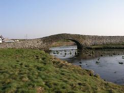
The walk starts off at the car park beside the packhorse bridge in Aberfraw. Cross the bridge and when on the western side of the river turn left and follow a footpath southwards along the banks of the river. The footpath climbs uphill slightly and when it is adjacent to the beach it turns to the right to head westwards towards Braich-lwyd, where it turns to the north once more for a little under a kilometre until it reaches the beach of Porth Cwyfan.
If the tide is out then follow the beach around to the church on the islet, but if the tide is high then there is a footpath in the fields above the beach. Near the church a track leads inland to the north, skirting the Ty-croes motor racing circuit before joining a road at Llangwyfan-isaf, which can be followed northwards to the A4080 road.
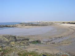
Turn left along the A4080 road until a car park by Porth Trecastell is reached. Enter the car park and then join a footpath that heads westwards around a little headland. At the tip of a headland you pass the restored chambered cairn of Barclodiad y Gawres beore the footpath curves around to head back towards the A4080 road. If the tide is low then before the road is met drop down onto the beach and walk northwestwards along it towards Rhosneigr, and then climb up a slipway into the town.
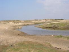
Continue up past the end of the slipway and follow the road as it curves around to the right to head northeastwards through the town. By a clock tower it meets the A4080 road, so continue down this road past the fire station before taking a road off to the left. A few yards down this road a track leads off to the right, which lead towards a footbridge over the Afon Crigyll. Cross the bridge and on the other side turn left to head westwards through the dunes. The path meets the boundary fence of RAF Valley before heading away and eventually meeting the beach near the island of Ynys Feirig.
When the beach is reached turn right to head northwestwards along Traeth Cymyran until you reach the white house at Plas Cymyran. Here turn right to walk northeastwards along a track for about a kilometre until it reaches a car park. From here the Anglesey Coastal Path follows a series of permissive paths up to Four Mile Bridge on the B4545 road; these were hard to follow so it may be best to use local roads to get there.
This will not be a much longer route, and hopefully the footpaths will improve over time. From Four Mile Bridge turn left to cross the bridge, and near the post office in the village turn left down a road that leads southwards for a couple of miles to the village of Rhoscolyn. In the village turn left to head along a narrow, twisting lane that ends at a car park by the beach in Borthwen.
From Borthwen take a footpath that heads south towards Ynys Traws, before turning to the right to head northwestwards to he coastguard lookout at the top of the hill. Start the descent downhill and skirt St Gwenfaen's Well and then follow the footpath (which is distinct on the ground) around the coast until it reaches a road in a caravan park. Join this road and follow it northeastwards until it reaches the B4545 road in Trearddur, where this walk ends.
Distances
| From | To | Distance (m) | Ascent (ft) | Descent (ft) |
|---|---|---|---|---|
| Aberffraw | Rhosneigr | 6.8 | 463 | 430 |
| Rhosneigr | Rhoscolyn | 8.3 | 420 | 387 |
| Rhoscolyn | Trearddur | 4.2 | 577 | 636 |
This makes a total distance of 19.3 miles, with 1460 feet of ascent and 1453 feet of descent.
For more information on profiles, ascents and descents, see this page
Accommodation
We parked Mervan on a quiet road next door to the car park in Trearddur that was quite handy for the local facilities, including a couple of pubs and a shop.
Disclaimer
Please note that I take no responsibility for anything that may happen when following these directions. If you intend to follow this route, then please use the relevant maps and check the route out before you go out. As always when walking, use common sense and you should be fine.
If you find any information on any of these routes that is inaccurate, or you wish to add anything, then please email me.
All images on this site are © of the author. Any reproduction, retransmissions, or republication of all or part of any document found on this site is expressly prohibited, unless the author has explicitly granted its prior written consent to so reproduce, retransmit, or republish the material. All other rights reserved.
Although this site includes links providing convenient direct access to other Internet sites, I do not endorse, approve, certify or make warranties or representations as to the accuracy of the information on these sites.
And finally, enjoy your walking!
This walk was mentioned in the following routes:
| My walk around the coastline of Britain |
Nearby walks
| # | Title | Walk length (miles) |
|---|---|---|
| 407 | Barras to Aberffraw | 18.3 |
| 409 | Trearddu to Llanfachaeth | 19.0 |
| 410 | Llanfachraeth to Cemaes | 18.2 |
|
|

|