Walk #203: Huntingdon to Peterborough
 |
 |
|
General Data
| Date Walked | 19/05/2002 |
| County | Cambridgeshire |
| Start Location | Huntingdon |
| End Location | Peterborough station |
| Start time | 08.24 |
| End time | 16.57 |
| Distance | 24.5 miles |
| Description | This was a long yet enjoyable walk, mainly along roads, between these two towns. The flat fenland is not everyone's cup of tea, but I find the 360-degree views to be quite exhilarating in their own way. |
| Pack | A daysack with coat, Psion 5, and a few other little bits and bobs. |
| Condition | I am understandably knackered after this walk, but I could have walked further if I had had a little rest. I have what could be the start of blisters on the back of my heels, a result or wearing my trainers and thousand-mile socks. My right shoulder ached near the end of the walk, and I walked without the right strap on my shoulder for half an hour. My legs were aching at the end of the walk, and once I had stopped and sat in the car for a while they were quite stiff. My Tilley hat was being washed and I took no sun tan cream with me, and so I have caught a little too much sun. I may also have a little heatstroke and got slightly dehydrated, as I felt slightly light headed towards the end of the walk. |
| Weather | The long-range weather forecast for today has been for showers, but this changed last night to a forecast of sunshine and clouds, with rain coming in from the west later on. And this was exactly how the day was; it started off sunny with some sparse cloud cover. As the day went on the temperature rose and the cloud cover reduced slightly, until in the early afternoon it was very hot. Later on in the day there was more cloud cover and the sun became obscured, but this soon passed and it was sunny once more. Fortunately there was a stiff breeze all day that helped keep the heat off me for much of the time. |
| OS map | Landranger number 153 (Bedford & Huntingdon, St Neots & Biggleswade) and Landranger number 142 (Peterborough, Market Deeping & Chatteris) |
 |
 |
|
Map of the walk
Maps courtesy of Google Maps. Route for indicative purposes only, and may have been plotted after the walk. Please let me have comments on what you think of this new format. For a detailed table of timings for this walk, please see the table file.
Notes
I wanted my first walk after my long trip through Scotland to be a long one, and so I decided to use this opportunity to polish off two walks that I had been planning to do in one go, namely the ones from Huntingdon to Peterborough. Doing this would have the advantage of creating another circular walk, namely the Waterbeach - Huntingdon - Peterborough - March - Ely - Waterbeach route. Yesterday I went for a 30-mile bike ride with Sam around to the west of Cambridge, and therefore my legs were feeling finely tuned for this long walk.
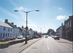
The start of the walk through the town of Huntingdon was fairly boring, but this soon finished and I found myself abruptly walking north along a quiet road. Some of the villages that I passed through were quite nice, and they made a big change from the solitude of the surroundings I had had in Scotland.
When I got to Ramsey I tried a few pubs, but the three I tried did not open until midday, which was till a fair while away. I decided not to stop until I got to the public house that was marked on the Ordnance Survey map at Ramsey Mereside. When I got here I found that the building that the pub was in was more like a village hall than a pub, and there were many locals sitting within it. I sat down in a corner and started measuring my maps to work out how far I had gone and how far I had to go. I was quite surprised to find out that I had already walked over fourteen miles, with the only noticeable problem being a slight sore spot on the back of my right heel. This is a good sign of exactly how fit I am at the moment, and it would be very nice to be able to maintain this for as long as possible.
After leaving the pub in Ramsey Mereside I saw an elderly man who was sitting in a chair in his back garden. I wished him a good afternoon and he replied in a Scottish accent. This intrigued me and I chatted to him for a few minutes. He was originally from North Queensferry, which I have walked through in the past, and he used to work on the ferries that plied the Firth of Forth before the Forth bridge was made. When it had been opened he was made redundant, and he and his wife moved down to Ramsey. He said that he loved the wide, expansive skies, and he had no desire to move back to Scotland.
When I got near to Pondersbridge I phoned my girlfriend up so that she could give me details of trains from Peterborough to Cambridge off the Internet. She had dropped me off at Huntingdon earlier in the day, and she offered to pick me up from Peterborough. This saved me having to get a train back, and the offer was gratefully accepted.
There was a large motorbike show on in Peterborough today, and the roads were packed with far more motorbikes than is normally the case. Our journey back was delayed at a roundabout leading onto the A1(M) as a policecar slowly moved around the roundabout, blocking junctions so that traffic cold flow more easily against the unceasing flow of motorbikes leaving the show.
Although this walk will not be everyone's cup of tea, I found it a highly enjoyable stroll. I think the main factor that made it nice was the sheer change from Scotland, with no hills of any size being seen or climbed all day. Vive la difference!
Directions
This walk starts off at Huntingdon Station, to the south of the town of Huntingdon. Leave the station and turn right to head north-eastwards along the B1514 road towards the centre of the town. When the road ends at a T-junction with the ring road head straight on along a road which soon ends at another T-junction beside a church. Turn right and then left, to head north-eastwards past the Oliver Cromwell museum along a road and then a footpath. The footpath skirts the eastern edge of a small area of park before it ends at the inner ring road.
At the ring road turn left along the road for a short distance until the western end of the park is reached. Cross the road and then turn right, heading northwards up another road for about a mile past a leisure centre until the road ends at a T-junction. From here a surfaced path continues straight on for another half mile along a green corridor between houses until it ends at a T-junction with another road. Cross over this road by a bridge and follow a raised footpath to a small shopping centre. Continue straight on along the raised footpath, which follows the western side of a road as it heads northwards. After about 500 metres the footpath meets the road on the level, and the road ends at a T-junction. Turn right and follow the road northeastwards for a short distance until it approaches the A141 road. When the road turns sharply to the right alongside the road go through a gap in the hedge, which separates the two roads and go onto the verge of the A141. Carefully cross the A141 and start heading north-eastwards along the road that starts on the opposite side of the road.
The road continues northeastwards for a couple of kilometres until it meets the B1090 road. Cross the road and continue straight on into the lovely little village of Kings Ripton. Continue on through the village and head northwards along the same road out of it. This road was nice and quiet when I walked it, with some reasonable Fenland views available. At a crossroads continue straight on and follow the road as it slowly starts to turn north-eastwards towards the village of Wistow.
When the road enters the village take the first road to the left, which heads north-north-westwards downhill. The road becomes nothing more than a farm access track and when it turns sharply to the left to head towards a farm continue on through a gate along a concessionary footpath which follows a track. When this path ends cross a ditch by a little bridge and turn left to follow another concessionary footpath that heads west to meet the southern edge of Rolts Wood. The path follows the southern edge of the wood before slowly climbing to end at a road on the eastern edge of the village of Upwood.
At the road turn right to head north-north-eastwards out of the village. After a few hundred metres the road turns to head eastwards before turning to head north-eastwards to run alongside the south-eastern edge of a now-closed RAF base. The road then runs alongside the western edge of the village of Bury before ending at the B1040 road on the southern edge of the town of Ramsey.
Join the B1040 road and follow it northwards for a little under a kilometre towards the centre of the town. Shortly after the road turns to head on a more easterly heading a junction is met with the B1096 road. At this junction turn left and follow the B1040 as it heads north north westwards for half a kilometre. Just before High Lode is reached on the northern edge of the town turn right and follow a road north north eastwards for a mile across Stocking Fen. A little less than half a kilometre after the road turns sharply to the right to head eastwards another road junction is reached.
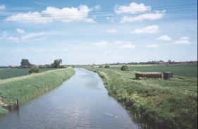
At this junction turn left to head northwards, passing Bodsey House before Bodsey Bridge over the River Nene (old course) is reached. After this the road turns to head northwestwards for a mile to reach the small village of Ramsey Mereside. Continue along the road through the village for about four kilometres until the B1040 is reached in Pondersbridge.
When the B1040 road is reached turn right and cross Bevill's Leam by a bridge. Immediately once the bridge is crossed turn left and follow the 1095 initially westwards and then northwestwards. Pass a public house and phone box and take the first road to the left (called Wrights Drove), which heads south south westwards for about half a kilometre until it ends at a T-junction with another Straight Drove. At this junction turn right to head south-north-westwards for nearly four kilometres into the village of Farcet, crossing the River Nene (old course) once more on the eastern edge of the village.
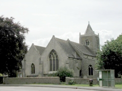
When the road ends at a T-junction with the B1091 by the church in Farcet turn right and follow the B1091 road northwards for a couple of kilometres until it ends at a roundabout with the A605 road in Stanground. A subway can be used to cross under this road. Once on the northern side the road can be followed along a cycle track to the north for a short distance to another roundabout. Continue across this roundabout and follow the road as it passes under the dual carriageway road. As it does so it swings around to head westwards. After a few hundred metres it turns sharply to the right to head northwards through New Fletton. It passes over a the Peterborough to Ely railway line before reaching the bridge over the River Nene.
Cross the River Nene and when the road swings around to the right continue straight on into a pedestrianised area. Continue through this area and then cross a dual carriageway by a pedestrian crossing into another pedestrianised area. Continue straight on towards the market square. Turn left and follow the signs towards the railway station.
Distances
| From | To | Distance (m) | Ascent (ft) | Descent (ft) |
|---|---|---|---|---|
| Huntingdon Station | Wistow | 6.7 | 167 | 167 |
| Wistow | Ramsey | 4.4 | 102 | 151 |
| Ramsey | Farcet | 9.9 | 75 | 36 |
| Farcet | Peterborough Station | 3.5 | 56 | 82 |
This makes a total distance of 24.5 miles, with 400 feet of ascent and 436 feet of descent.
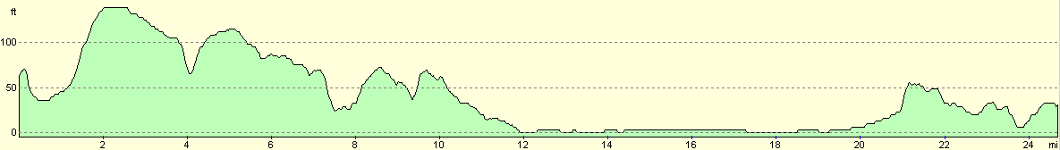
For more information on profiles, ascents and descents, see this page
Transport
There are regular services run by GNER and WAGN trains between Peterborough and Huntingdon stations. There are also bus services that run between the two towns.
Disclaimer
Please note that I take no responsibility for anything that may happen when following these directions. If you intend to follow this route, then please use the relevant maps and check the route out before you go out. As always when walking, use common sense and you should be fine.
If you find any information on any of these routes that is inaccurate, or you wish to add anything, then please email me.
All images on this site are © of the author. Any reproduction, retransmissions, or republication of all or part of any document found on this site is expressly prohibited, unless the author has explicitly granted its prior written consent to so reproduce, retransmit, or republish the material. All other rights reserved.
Although this site includes links providing convenient direct access to other Internet sites, I do not endorse, approve, certify or make warranties or representations as to the accuracy of the information on these sites.
And finally, enjoy your walking!
Nearby walks
| # | Title | Walk length (miles) |
|---|---|---|
| 55 | Peterborough to Whittlesey | 8.6 |
| 56 | Peterborough to Stamford | 16.5 |
| 71 | March to Peterborough | 20.3 |
|
|

|