Walk #202: Sandwood Bay to Cape Wrath
 |
 |
|
General Data
| Date Walked | 07/05/2002 |
| County | Highlands |
| Start Location | Sandwood Bay |
| End Location | Cape Wrath Lighthouse |
| Start time | 09.20 |
| End time | 13.10 |
| Distance | 7.7 miles |
| Description | This was a rough and hard walk along trackless moorland. It was fairly enjoyabl despie this, and I enjoyed the scenery much more than I was expecting. |
| Pack | Full pack with four days food. |
| Condition | My bad left ankle took a lot of stress during this walk, with rough hummocky grass, bog and uneven rocks all adding up to make for vey tough going on it. Despite this it only ached at the end of the walk which is a positive sign. I also had a little gip from my right knee, but that is now the norm for this trip. Aside from these I feel fine - my feet are okay despite the fact that my left boot leaked. I only put on a pair of inner socs today with no thick outer socks, and this did not aversely effect my feet. |
| Weather | The day started off bright and sunny with slightly more cloud than yesterday, but early on a sea mist started to roll in. Fortunatteely erly on in the walk this started to lift and bright snshine replaced it.I did not get too hot despite the exertion of the walk, but I cannot recall too much wind. |
| OS map | Landranger number 9 (Cape Wrath, Durness & Scourie) |
 |
 |
|
 |
 |
|
Map of the walk
Maps courtesy of Google Maps. Route for indicative purposes only, and may have been plotted after the walk. Please let me have comments on what you think of this new format. For a detailed table of timings for this walk, please see the table file.
 |
Notes
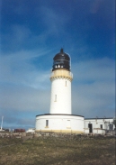
So I have done it. After 245-odd miles I have reached Cape Wrath three days ahead of schedule. The first glance of the lighthouse I saw from the road brought tears to my eyes - I have waited for over two years to get here, and finally the deed is done. The feeling of exhillaration and relief is overwhelming, and I am filled with emotion.
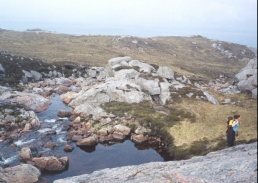
This walk was hard. Very hard. There were no paths and the terrain was difficult, especially with my pack on. Having said that, I have no doubt that I could do it again if the need ever arises and next time I ma take sightly longer over it. The hardest bit was the descent down to the Keisgaig River and the ascent up the other side. Here Lucy and Ros chose to go by the route mentioned in the guidebook, but as I did not fancy doing the scramble with my rucksack on I chose to go on a longer route where the climb should not be as steep. Unfortunately this involved me going over some very boggy ground, which slowed my progress. Then when I got to the river I found the perfect place to cross - stones in the river which would allow me to keep my feet dry. Unfortunately the place was about ten feet down a very steep slope. The first part of this was traversed using a sheep track, but the last bit could only safely be done by sliding down on my bottom and rucksack. When I got to the bottom my trousers were thoroughly muddy and I rested before starting the ascent up the other side.
I made much better time than I was expecting today, as I followed Ros and Lucy all the way. They were carrying lighter packs than me and were probably fitter, and I found it hard going keeping up with them. I managed it though, and I arrived at the lighthouse only ten minutes or so behind them, after a pause when I reached the road for the first time.
On the way down from the bealach between Sithean na h-lolaireich and Cnoc a' Ghiubhais we saw the white minibus trvelling along the road in the distance. Two or three minutes after I got to the road it passed me going back, and as I believe that that was it's only journey for the day I realised that I would be forced to camp out or use the bothy for the night. I was not too concerned about this because although it was annoying the end is so much in sight that another night really does not bother me one bit if it is needed to be able to complete the task at hand.
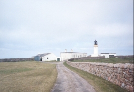
When I reached Cape Wrath I found a side of the building that was sheltered away from the wind and in the sun and just sat down, thinkng. It as not too far to the bothy so I decided to wait around for a bit, relax and take in the sense of achievement that I got from the task that I had just completed. I then went to find Ros and Lucy so that they could take a photograph of me at the lighthouse - proof if any were needed that I had made it.
When Ros and Lucy left just before 14.00 I felt overcome with emotion and even started crying - but then I saw the minibus heading back past them and I suddenly felt the call of civilisation in my ears and in my heart. Before I saw the minibus I knew that the only sane and sensible thing for me to do was to spend the night at Kervaig Bothy, set off early tomorrow morning and walk to the ferry. Although it may have been the sane and sensible ting to do, as soon as I saw the minibus my heart was simply not in it. The whole aim of this walk had been to get to Cape Wrath, and I have now done so. All I wanted to do was go home to see my lovely girlfriend and to rejoin my 'normal' life. I feel a pull to do the walk from Cape Wrath to Durnesss tomorrow, but my heart is simply not in it. I have had enough; I have done what I set out to do and that is where I will leave it. I can worry about the Cape Wrath to Durness section another time; I am in no great hurry to finish off my Land's End to John O'Groats walk - indeed I do not even want to think of that at the moment.
Whilst I was waiting for the minibus to head back I chatted to the man who was driving it. As long as I had known about the minibus service I had wondered how they got it over the Kyle of Durness, as the road it runs along from the Kyle to Cape Wrath is not connected to the rest of the road network. It turns out that every year it is floated across on a pontoon which is owned by the local fish farm, and back again at the end of the tourist season later in the year.
So what are my abiding memories of this walk? It has been a very emotional walk, much more so than the Pennine Way was. I think that my life has fundamentally changed since those days, and I find it hard to be away from Sam. I miss her voice, I miss her looks, I miss her. Full stop. I need her. And the lure of walking - the scenery, the sense of achievement, the people I meet - all pale into insignificance behind her. I daresay in a few weeks I will want to go on another long hike, but this is how I feel at the moment, lying in bed in the B&B in Durness.
After having had a shower in the B&B I have been thinking about this more and it is like this; on a trip like this the only way that you can remain focussed and sane is to take each day as it comes. Each morning you look at the weather and how you feel and work out where you are going to walk to that day. If I were to start looking on the first day at the end objective, in this case Cape Wrath, it would become to overwhelming and, in a sense, depressing. Therefore I try and tick off another walk, another small but vital piece of the jigsaw called 'the objective'. The objective of this walk was to get to Cape Wrath. That was what the sponsorship forms said and that was what I set out to do. Durness was just a nebulous entity that was outside the scope of my world during the last eighteen days; it was not part of the big thing called 'the walk'. For this reason when I finally reached Cape Wrath and the minibus came all energy sapped out of my body; I had done it. Completed it, and the means of transport back to reality was upon me. If the minibus had not made two trips that day I would happilly have continued on to Kervaig Bothy and then Durness the next day. But that was just an aside to the entity called 'the walk'. A very handy entity for the future maybe, but the future is not yet planned and all my enersy deserted me as soon as I saw that minibus passing the two girls. The objetive, the target, my raison d'etre for the last eighteen days had been reached. It was over.
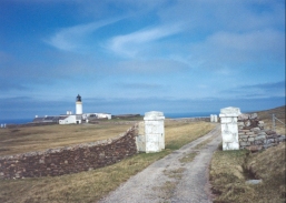
There have been many highs and lows on this trip - I reached Cape Wrath but not by the route I had intended for starters, but I still feel an enormous sense of achievement. I have done it. Befor today Cape Wrath may as well have been on the other side of the moon, but I have ssuccessfully walked there. Walking through the gateway into the compound at the lighthouse was an incredibly emotional moment, and I found the memories of the last two and a half weeks whizzing around my head as I continued on into the compound. There was no ticker-tape parade, no brass band to greet me, but I knew what I had achieved, and at the end of the day that is all that matters. I need time to myself to reflect.
So what next? The future seems a very strange concept having just completed something that I have waited two and a half yars to do. Well, this year I would like to finish off my Land's End to John O'Goats walk. Not doing the Cape Wrath section will make that more difficult but still very achievable. And after that? I now know that I a fit enough to do the Coastal Walk easily (or as easy as 4,500 to 5,500 miles can be) if I am supported and do not have to carry a pack. Carrying a pack for fifteen miles a day for weeks slowly saps my physical and, more importantly, my mental energies. Having a friendly face to come home to each night would help keep a sense of reality and perspecive on things. I have found it most telling that I have not used my tent much on this trip, and have preferred to spend the money and use a hotel or B&B instead of camping. When I am alone a B&B acts as an anchor to reality, a reminder of who I am and what I am doing which you just do not get from a tent. And in this I have learned ore about myself than any psychoanalyst could ever tell me.
I woke up early this morning at about 5.30, and had a look outside the tent. It was lovely and sunny, with a little bit more cloud than yesterday. At about 6.15 a sea mist started rolling in, and it was qute majestic seeing it roll up the loch. Because of this my idea of an earlyy start had to be aborted, and I read ysterday's paper until Ros and Lucy got up. I also went for a walk up the loch, which in the mist was nowhere near as beautiful, and stoked the fire. When the girl's got up they were kind enough to make me a bacon sandwich, which went down well after the cup of coffee that I had made earlier. This was a very kind act, and one for which I was very grateful.
There were too many people on the minibus for just one crossing on the ferry, so a few of us had to wait a few minutes for the ferry to come back again. On its first journey it offloaded a man and a woman who were obviously hikers from the size of their packs. They were going to be walking to Inchnadamph on this trip, and were hoping to get to either Kervaig Bothy or Strathan Bothy (that latter of which is at the eastern end of Sandwood Loch). Considering it was nearing three in the afternoon by the time they disembarked from the ferry I thought that getting to Strathan bothy - which would involve all the distance that I have walked today, plus eleven miles to Cape Wrath plus one mile to Sandwood - was very ambitious. They seemed anxious to set off, and I wished them all the best in their walk.
The mist early on in the walk was quite bad, and spoiled an views that there may have been in the first hour. Fortunately by the time the hour was up the mist had more or less lifted and navigation became much easier. As soon as I met up with Ros and Lucy once again after about twenty minutes I decided that it may be safer if we stuck together, so I decided to follow them. This made the walk much more enjoyable than it would otherwise have been, and ensured that it ended in a literal high point.
Durness is the most north-westerly inhabited area in Britain and is home to about 320 people. It has a small shop, a small supermarket, petrol station and a seasonal Tourist Information Office. All in all it is quite a nice little village, and I was pleased to be able to spend a few hours here.
Postscript On the 20th of June 2002, I went to the Riding School for the Disabled branch in Milton to give them the cheque for the money that I raised. I have a webpage with photographs on of myself presenting the cheques to the RDA, and of the great work that the RDA do.
Directions
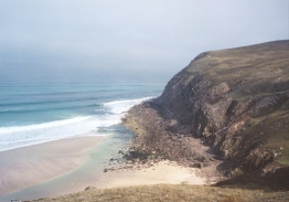
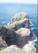
This walk starts off at the northeastern corner of Sandwood Loch, on the eastern side of the river that runs between the loch and the sand dunes. The route to be taken is mostly indistinct and unpathed, so the following is only a guideline and it may be best to try and make your own route. One fact remains constant, however; staying close to the coast gives a dryer route whilst inland the ground is far boggier and harder going. However diversions inland are necessary for the couple of rivers that need crossing, and the cliffs cn be steep and dangerous, so care is needed.
I started off by climbing the steep hillside that it is to the eastern side of the river. The nearer to the sea that you attempt to climb it the steeper it is; for this reason I chose to start the climb a couple of hundred yards inland near the northern tip of the loch. The climb is steep but relatively short, and I found it a fairly easy climb even with my pack on. Once at the top I starts angling back towards the coast, heading northeastwards.
After a couple of kilometres the Strath Chailleach is reached. We crossed this slightly inland where the descent down to the river and ascent up from it are far easier and less dangerous than it wouldhave been nearer the sea. The crossing was fairly easy, with a rocky river bed allowing a stepping-stone approach to be used.
Once we had ascended up from the river we angled to pass on the coastal side of the Cnoc a' Gheodha Ruaidh hill, where there was the semblance of a path skirting the hillside. A minor descent is then followed by an ascent as the path ends, and this is followed by an ascent up to the top of another minor hill where as I recall the path became indistinct and ended.
This is followed by a long descent down towards the Keisgaig River. There are two ways up from the river, and it is probably best to decided wich you are going to do before you start the descent; you can try and cross near the sea where there is a stream running down the northern flank of the river which can be followed up; or you can do what I did and head further inland to another stream which can be followed. The advantge of the former route is that it is shorter but it has a steep, almost scrambling bit, and it involves more climbing; the advantage of the latter route is that it does nt climb as far, does not involve scrambling but it is a slightly longer route and the ground on the southern side of the river is fairly boggy.
However you cross the river, ascend up the northern flank heading for the bealach between the hills of Sithean na h-lolaireich and Cnoc a' Ghiuihais. This is a steep ascent that tired me out, so I had a litte rest at the top of the saddle, where there were some lovely views available. From the saddle starts descending northeastwards. The route that we took soon turned to head northwards across the moorland, passing to the east of the river that runs to the east of the hill of Dunan Beag. As we neared the road a last stream had to be crossed and we hit the road near the top of the western ascent from the inlet from Clais Charnach.
Once the road is met the route is simple; just turn left and follow the road as it skirts around the hill of Dunan Mor for a little over a mile until the lighthouse complex of Cape Wrath is reached.
This route is mentioned in the excellent book "North to the Cape", by Denis Brook and Phil Hinchliffe, Published by Cicerone Press, and ISBN 1-85284-285-7.
For details of an lovely walk from Kildonan to Cape Wrath, have a look at Lizzie and Andrew Smith's webpages at http://www.lizzieandrew.pwp.blueyonder.co.uk/.
Distances
| From | To | Distance (m) | Ascent (ft) | Descent (ft) |
|---|---|---|---|---|
| Sandwood Bay | Keisgaig River | 3.7 | 994 | 741 |
| Keisgaig River | Cape Wrath | 4.0 | 712 | 669 |
This makes a total distance of 7.7 miles, with 1706 feet of ascent and 1410 feet of descent.
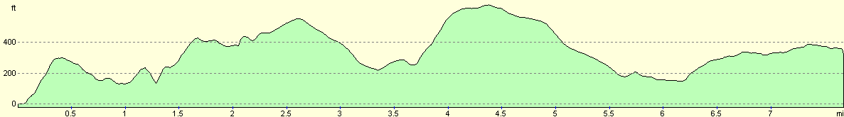
For more information on profiles, ascents and descents, see this page
Transport
I used the Cape Wrath minibus and ferry service to get back from Cape Wrath to Durness. These services are seasonal, and run if there is enough demand during the tourist season. I was lucky as they ran two trips on the day that I reached the lighthouse, as at this time of the season they usually only run one. Details of the ferry can be obtained by calling 01971 511343 and the minibus by calling 01971 511343 or 511287.
Also note that these services do not run during the tourist season if there is naval bombing going on on the range. Again, ring the numbers above to find out if the services will be running whenm you need them.
Accommodation
I stayed at 'Foinaven', Durine, Durness, Sutherland, IV27 4PN, run by Mrs. Carol Keith. It can be contacted on 01971 511726. It cost 25 pounds for a nice en-suite room. There are also several other B&B's.
There is also a hotel (and another under refurbishment), a campsite and a recently opened bunkhouse which offer accommodation.
Disclaimer
Please note that I take no responsibility for anything that may happen when following these directions. If you intend to follow this route, then please use the relevant maps and check the route out before you go out. As always when walking, use common sense and you should be fine.
If you find any information on any of these routes that is inaccurate, or you wish to add anything, then please email me.
All images on this site are © of the author. Any reproduction, retransmissions, or republication of all or part of any document found on this site is expressly prohibited, unless the author has explicitly granted its prior written consent to so reproduce, retransmit, or republish the material. All other rights reserved.
Although this site includes links providing convenient direct access to other Internet sites, I do not endorse, approve, certify or make warranties or representations as to the accuracy of the information on these sites.
And finally, enjoy your walking!
Nearby walks
| # | Title | Walk length (miles) |
|---|---|---|
| 201 | Rhiconich to Sandwood Bay | 12.8 |
| 522 | Rhiconich to Sandwood Bay | 12.5 |
| 523 | Sandwood Bay to Kearvaig via Cape Wrath | 13.0 |
|
|

|