Walk #201: Rhiconich to Sandwood Bay
 |
 |
|
General Data
| Date Walked | 06/05/2002 |
| County | Highlands |
| Start Location | Rhiconich Hotel |
| End Location | Sandwood Bay |
| Start time | 09.35 |
| End time | 15.07 |
| Distance | 12.8 miles |
| Description | This was a very enjoyable walk of two halves; an initial road walk along the southern side of Loch Inchard which was followed by a nice walk up to Sandwood Bay. |
| Pack | Full pack with five days food. |
| Condition | I feel fine after this walk. My shoulders ached less than they did yesterday and I am generally otherwise okay. I have no new blisters and for once my right knee did not give me any trouble. My left ankle is aching slightly, but no more than it has on other days of this trip. I also have some chafing between my thighs despite having used Vaseline, so I may have to be careful tomorrow. |
| Weather | Today's weather was beautiful, with a hot sun blazing down being partially counteracted by a cooling breeze, particularly on the beach at the end of the walk. The temperature was reasonable, probably in the region of seventeen degrees or so, and there were some wispy high-level clouds to give the sky a variegated appearance. |
| OS map | Landranger number 9 (Cape Wrath, Durness & Scourie) |
 |
 |
|
Map of the walk
Maps courtesy of Google Maps. Route for indicative purposes only, and may have been plotted after the walk. Please let me have comments on what you think of this new format. For a detailed table of timings for this walk, please see the table file.
 |
 |
|
Notes
In nice weather I usually like to try and extend the walk by having a long lunch break, and on this walk the hotel in Kinlochbervie would have been an ideal place to spend an hour or so. Unfortunately when I got to the hotel I found out that it was not due to open until midday, and I did not fancy waiting around for half an hour. This was a pity, as I quite fancied having a nice last meal before a couple of nights camping - it would have made a change from rice!
On the outskirts of Kinlochbervie were a couple who were outside a house that was under renovation. They waved to me and as I was in no particular hurry I walked over to them and started chatting. It turns out that they had only recently moved to the village, and before that they kept a B&B in Kirk Yetholm, dealing with the Pennine and Saint Cuthbert's Way trade. Unfortunately the foot and mouth outbreak last year had dealt them a blow, so they had decided to move to Kinlochbervie. They were a very friendly couple and it was a nice chat, so I wished them all the best in their new ventures.
At the start of the track at Blairmore I met a gentleman who was creosoting the gate that provides access to the track that leads to Sandwood Bay. It turns out that he is a part-time warden for the John Muir Trust who owns the land around the bay, and he warned me that the building at Sandwood was no longer a bothy. We had a quick chat, and he managed to give me some very useful information about the rest of my journey.
In the car park at Blairmore a minibus left whilst I was there, and on the trail I met many other people coming back with lilos, surfboards and other paraphernalia. There were about twenty of them who had been camping at the northern end of the loch, and from the size of the bin bag full of beer bottles and cans I think that they must have enjoyed themselves!
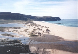
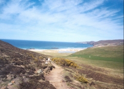
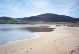
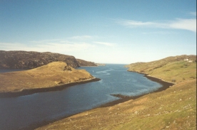
The track from Blairmore to Sandwood Bay was rocky and hard going in some places and good in others, which meant that that little section took me longer than I had been planning. The path passed several lovely little lochs, some of which had their own little sandy shores leading to the deep blue water. As I crested the last ridge I could see Sandwood bothy and I could also see why it was no longer a bothy - it is now no more than a roofless shell. Shortly after this I got to see the high cliffs stretching northwards and, joy of joys, the very top of the lighthouse at Cape Wrath. I had not been expecting to see this and the sight of it caused me to give an audible 'wow!', which I then had to explain to the couple who were in front of me. It was an amazing feeling to see the end of my hike in sight, even though I still had another seven or eight miles to walk to reach it.
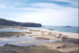
Sandwood Bay is very busy, and I keep on coming across tents hidden away in various places. I suppose that being a bank holiday weekend many people will have come up here for a long stay, but as it is Monday afternoon I am quite surprised that so many people are still here. When I arrived there were even some surfers who were packing up ready to go home - apparently it is a very nice place to surf.
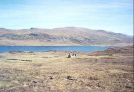
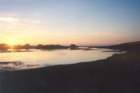
When I got to Sandwood Bay I found myself in a bit of a dilemma; part of me wanted to carry on to the bothy at Strathan, but another part wanted to stay on or near the beach. I was very much in two minds about this, as going on a bit further meant that I could stay in the bothy, which is a slightly illogical thing for me to want to do on such a lovely afternoon. On the other hand it meant that I would have a mile and a bit less further to walk tomorrow, which promises to be a hard day. In the end I decided to camp on the northern side of the loch, if only because it appeared to be a totally sublime place. There were also people about, so I could well be able to have a chat in the evening.
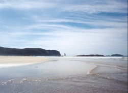
It was very nice finding a place on the northern side of the loch and staring out to sea, watching ships slowly head south having gone around Cape Wrath, 'the turning place'. I just sat and watched the waves roll in and break on the beach, sheltered from the slight northerly breeze by the cliffs that I will have to climb tomorrow. Sandwood Bay is the last place in Britain that a mermaid was spotted, in the nineteenth century, and is also reputed to be haunted by a ghost of a bearded sailor. Unfortunately I did not see any mermaids and the ghost did not wake me from my slumber, but the night was memorable enough without either of these events.
I have several choices about what I could do tomorrow; I could set off late and take my time walking to the Cape and then stay in the bothy at Kearvaig on the northern coast, or I could set off early, get to the cape and then walk down the road until I meet the minibus. If I do the latter then I could get the minibus the next day and do the last walk unencumbered with heavy rucksack, and it would also avoid another night in a bothy. I am currently undecided about which of these I will do, and will probably end up seeing how I feel in the morning.
When I finally stopped lazing about on the beach and actually got around to deciding where I wanted to camp for the night it was about 17.15. I decided to place my tent near to the fire that I had spotted earlier, which was still smouldering. Unfortunately when I got my tent out I found that it was still damp from when I had last used it, so I staked the flysheet out on the ground and erected the inner with both flaps open so that it could dry out a little. Fortunately it appears to have dried without leaving a musty smell, although last time I used it I noticed a few spots of what could be mildew, which I will have to treat when I get home.
I have heard Sandwood Bay described as the best beach in Britain, and although I have not seen anything like them all yet it is the best one I know of. For one thing it is nice to see a beach without huts, stalls selling ice creams, steps down to the beach or people wearing kiss me quick hats. Indeed if it were not for the footsteps on the sand you could honestly call it unspoilt. It is a magnificent spot and long may it remain so. For more details on Sandwood Bay, see the Sandwood Bay website.
The large group who had been here before had left a fire smouldering, with some large - and I mean large, railway sleeper sized - baulks of timber on it. I met two lovely young ladies where I was camping, and we sat around the fire watching the sun slowly sink down towards the sea as we cooked. We also drained a lot of whisky, so I exchanged an unused camera film and some meths (which with only one night remaining I did not need) for some of their large bottle of Famous Grouse. I must admit that I rather like the idea of exchanging meths for whisky - this is a form of alchemy that seems better than converting base metals to gold.
One of the ladies is originally from Cambridge, indeed her parents live in Horningsea which is just down the road from where I live, and that was one of the topics that we talked about. It was really nice having some company in such a lovely spot, and I only hope that I did not bore them with my constant chatter. They are planning to walk to Cape Wrath and back tomorrow, so I may seem them on the journey. I do hope so, as walking for so many days alone without company (excepting American men with a bag in each hand) gets slightly uncomfortable mentally.
 |
 |
|
Directions
This walks starts off at the Rhiconich Hotel, on the A838 road. Leave the hotel and turn right to follow the A838 northeastwards for about a hundred yards. When the junction with the B801 is reached turn left and follow the B801 as it starts to head northwestwards along the eastern side of Loch Inchard.
Follow the B801 as it climbs and descends as it follows the side of the loch, passing Achriesgill, Inshegra and Badcall (where there is a shop) before descending down to the war memorial beside the Loch Innis na Ba Buidhe, beside which there is a war memorial in a lovely setting. The road then continues on westwards for a short distance into Kinlochbervie passing the harbour.
Shortly after the harbour turn right to head northwards along a road which passes the hotel before meeting the northwestern shore of Loch Innis na Ba Buidhe, which is shortly followed by a council highways depot on the right. At the top of the hill the road starts to descend northwestwards past Loch na Larach before reaching a road junction in Oldshoremore.
At the junction turn right to head northwards and descend to cross a stream by a bridge. The road then starts to climb uphill and head northwestwards to another road junction to the left, which leads to Oldshore Beg. Do not take the road to the left but continue on to the right, to head northwards and then westwards into the tiny hamlet of Blairmore.
Just before a little car park is reached a track leads off to the right. This car park was created by the John Muir Trust who own the land around Sandwood Bay, and is used to stop people driving up the track towards the Bay. The track heads northwestwards through a gate, passing to the west of Loch Aisir and then the right of Loch na Gainimh. The track is fairly distinct and well-formed at this time, and it is easy to follow the path as it turns to head northwards.
On the way northwards to Loch a' Mhuilinn the track slowly becomes rougher and more rocky. When the track reaches the eastern shore of the loch it finally ends and the way onwards becomes a path. As it leaves the shore of the loch it slowly starts to turn to head northeastwards and then eastwards, passing the two lochs of Loch Meadhonach and Loch Clais nan Coinneal. It skirts the southeastern flank of Druim na Buainn before swinging northwards and descending down to the beach at Sandoowd Bay.
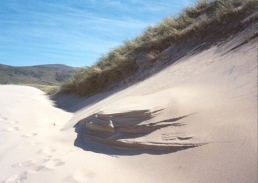
The next job is to find somewhere to camp in the area around the bay. Where the path meets the beach there are some dunes which could easily be camped in; I chose to camp on the northeastern side of the Bay, just across the river which flows from the loch into the sea. When I was there the stony bed of the river had been rearranged to make a little causeway across the river in one location, which allowed you to get across whilst keeping my feet dry.
This route is mentioned in the excellent book "North to the Cape", by Denis Brook and Phil Hinchliffe, Published by Cicerone Press, and ISBN 1-85284-285-7.
 |
Distances
| From | To | Distance (m) | Ascent (ft) | Descent (ft) |
|---|---|---|---|---|
| Rhiconich | Kinlochbervie | 4.6 | 896 | 879 |
| Kinlochbervie | Blairmore | 3.3 | 577 | 397 |
| Blairmore | Sandwood Bay | 4.9 | 269 | 512 |
This makes a total distance of 12.8 miles, with 1742 feet of ascent and 1788 feet of descent.
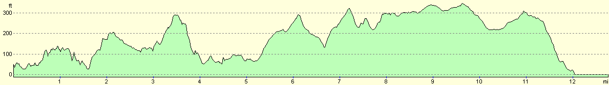
For more information on profiles, ascents and descents, see this page
Accommodation
I stayed in my tent at the north-eastern end of Sandwood Loch, at NC 2260 6517. This was a lovely spot for a campsite, and was far enough away from the beach for the sound of the waves not to disturb me.
Disclaimer
Please note that I take no responsibility for anything that may happen when following these directions. If you intend to follow this route, then please use the relevant maps and check the route out before you go out. As always when walking, use common sense and you should be fine.
If you find any information on any of these routes that is inaccurate, or you wish to add anything, then please email me.
All images on this site are © of the author. Any reproduction, retransmissions, or republication of all or part of any document found on this site is expressly prohibited, unless the author has explicitly granted its prior written consent to so reproduce, retransmit, or republish the material. All other rights reserved.
Although this site includes links providing convenient direct access to other Internet sites, I do not endorse, approve, certify or make warranties or representations as to the accuracy of the information on these sites.
And finally, enjoy your walking!
This walk was mentioned in the following routes:
| My sectional Land's End to John O'Groats walk |
Nearby walks
| # | Title | Walk length (miles) |
|---|---|---|
| 200 | Scouriemore to Rhiconich | 11.0 |
| 202 | Sandwood Bay to Cape Wrath | 7.7 |
| 521 | Duartbeg to Rhiconich | 14.9 |
|
|

|