Walk #200: Scouriemore to Rhiconich
 |
 |
|
General Data
| Date Walked | 05/05/2002 |
| County | Highlands |
| Start Location | Scouriemore |
| End Location | Rhiconich Hotel |
| Start time | 09.15 |
| End time | 13.50 |
| Distance | 11.0 miles |
| Description | This was a long road walk, with some lovely views but not as nice as those of the last couple of days. The road was fairly easy with only one or two steep gradients to contend with. |
| Pack | Full pack with five days food. |
| Condition | I feel fine after this walk, and I could easily have walked on further if the need had arisen. I got a slight sunburn on the back of my neck yesterday, and I feel as though I may have suffered more of the same today - the sun certainly felt stronger today than yesterday. The biggest problem today was with the shoulder straps on my rucksack - however much I tried I just could not get them to sit comfortably. This lead me to try and shrug my pack every few minutes so that the straps would move, and is probably a result of my having worn a fleece or coat for the majority of the days of the trip so far, so my shoulders were less cushioned than I am used to. |
| Weather | The weather today was lovely, with bright sunshine and not many clouds in the sky. It was hotter than yesterday, and so consequently I drunk more water than I usually do. A slight breeze built up later that helped me cool down a little, but even without this I was not too uncomfortable. Apparently the weather forecast is for this to continue for another four days, which is excellent as it means that I should have good weather when I get to Cape Wrath. |
| OS map | Landranger number 9 (Cape Wrath, Durness & Scourie) |
 |
 |
|
Map of the walk
Maps courtesy of Google Maps. Route for indicative purposes only, and may have been plotted after the walk. Please let me have comments on what you think of this new format. For a detailed table of timings for this walk, please see the table file.
 |
Notes
When I left the B&B I walked down into Scourie, walking across fields to the graveyard to the sound of a bleating chorus of sheep - I do not think that I have ever heard so many sheep bleating at such a high volume. Unfortunately the shop in the village as shut - as apparently it is every Sunday at this time of year - so I had to go to the small petrol station. This did not sell suntan lotion which was the main thing I wanted, but I used the opportunity to buy a choc ice, a couple of chocolate bars and a can of Red Bull.
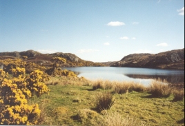
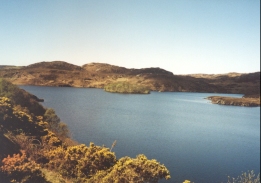
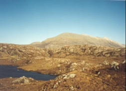
Some of the little lochs on the route looked absolutely magnificent in the bright sunshine, glistening like a dimpled mirror as the sun shone on the surface of the water. The yellow flowers of the gorse bushes beside the sides of the lochs added to this - the dark blue of the water, the light blue of the sky and the yellow of the gorse all added up to make beautiful views.
When I got to the hotel I dropped my pack off in my room and decided to have a drink and a meal before the kitchen shut. I made it in time, but it meant that I had yet to have a shower before I ate, which is not the best way to be seen in civilised company. I had a ham and cheese toasted sandwich washed down with a couple of pints of Threakstsons, the first of that beer I have seen on this trip.
In the lounge bar I chatted to a local couple, who were slightly less friendly than I have grown used to. When I asked if they had lots of walkers in the hotel the lady replied, "aye, we do" in a very resigned and regretful tone. They were not that bad though, as the kind lady gave me four pounds for the charity.
A man got killed on a motorbike yesterday afternoon just above the hotel, and the locals were busy chatting about it. I honestly cannot ay I am surprised when I have seen the way they ride - it is okay on roads which have two carriageways but up there it is a single carriageway road and it is quite bendy. Riding a motorbike fast up there is a recipe for disaster.
Aside from the incident the other talk was of the poor quality fishing, whether any stags had been seen and how busy the hotel is. Since this is a bank holiday weekend I do not find the latter surprising - if I was to make a journey up here I would prefer more than two days to do it in.
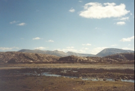
I had a little time to spare this evening before dinner, so I decided to go for a little walk up to the southern summit of Garbh Shron, in the gap between the A838 and B801. This was an enjoyable walk, although the going underfoot was very boggy in places that could well be a sign of things to come, but the views of Foinaven and Arkle to the east and Southeast were excellent. It was really nice to be able to walk without a heavy pack on, and this made the boggy ground easier to handle. On the way up the A838 I saw a section of dented Armco with two yellow police cones and a solitary bunch of flowers, obvious signs of yesterday's motorcycle crash. It was very saddening, and brought back to me how important life is.
I stopped for a while at Laxford Bridge, and sat on a grass strip outside a house. I took my boots off so that my feet could breathe and took my pack off and generally relaxed. The sun was shining, there was little traffic on the road and the views were lovely so I could easily have stopped there for longer.
Today's walk is quite an important one for me, as it is the 200'th walk that I have done since I started logging them at the beginning of 1999. To celebrate this I had an extra pint before my meal, and as I slowly drank it I thought about some of those walks and the places that they had taken me. It is quite a feeling to have got this far, and I wonder how long it will take me to get another hundred walks done.
I now only have another three days walking to do before I have reached Durness and the end of this trip. I felt that it was a good idea to spend a night in this hotel as for the next two nights I will either be camping or in bothies, so a bit of luxury has gone down well. The weather forecast is for it to remain fine for four days, so it looks as though I may see Sandwood Bay and Cape Wrath in the sunshine. This will be nice as they are the major two things that I have been looking forward to on this trip - the highlights of three weeks walking.
Directions
This walk starts off at the Scourie Hotel, which is on the A894 road in Scourie. Follow the A894 eastwards as it leaves the village, passing some public conveniences before meeting the western end of Loch a' Bhadaidh Daraich.
Follow the A894 for about a mile along the southern end of the loch. Shortly past this the road starts to curve to the north, climbing up a steep hill as it does so. At the top of the hill the road curves to the Northeast and continues for a little over a mile to the Loch s' Bhagh Ghanmhich.
The road follows the western and eastern sides of this loch before continuing on to the Northeast to meet Loch na Claise Fea'rna. About five hundred metres beyond the northeastern point of the loch the road curves around to head south-eastwards for about three kilometres. In doing so it descends and passes the little hamlet at Badnabay and the marshy area of Traigh Bad na Baighe.
Eventually the junctions of the A894 and A838 roads is met. Turn left to follow the A838 northwards across Laxford Bridge as the road turns into a narrow single carriageway. The road then heads northwestwards along the northern side of Laxford Bay. The road then becomes two carriageway once more and starts to turn to a north-easterly heading, ascending steeply as it does so.
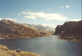
At the top of the hill the road skirts the eastern side of Loch na Fiacail and continues north-eastwards. The road crosses another loch on a causeway before turning to head northwards for a mile. The road then turns to a south-north-easterly heading, passing the road junction for Ardmore on the way, and descends downhill to the hotel at Rhiconich, which is at the south-eastern end of Loch Inchard.
Distances
| From | To | Distance (m) | Ascent (ft) | Descent (ft) |
|---|---|---|---|---|
| Scouriemore | Laxford Bridge | 6.5 | 709 | 719 |
| Laxford Bridge | Rhiconich Hotel | 4.5 | 814 | 781 |
This makes a total distance of 11.0 miles, with 1523 feet of ascent and 1500 feet of descent.
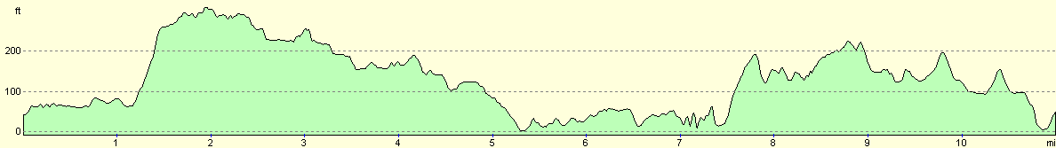
For more information on profiles, ascents and descents, see this page
Accommodation
I stayed at the Rhiconich Hotel, which is situated where the A838 and B801 meet. This cost 37 pounds for the night. This was a reasonable hotel with nice food, although the room that I had was slightly cramped and on the ground floor by reception, which meant that there was noise until late at night.
There is also a B&B a short distance up the A838 on the left, immediately past the junction with the B801. I know nothing about this B&B except for the fact that it is there - the signs for it were highly visible from the road.
Disclaimer
Please note that I take no responsibility for anything that may happen when following these directions. If you intend to follow this route, then please use the relevant maps and check the route out before you go out. As always when walking, use common sense and you should be fine.
If you find any information on any of these routes that is inaccurate, or you wish to add anything, then please email me.
All images on this site are © of the author. Any reproduction, retransmissions, or republication of all or part of any document found on this site is expressly prohibited, unless the author has explicitly granted its prior written consent to so reproduce, retransmit, or republish the material. All other rights reserved.
Although this site includes links providing convenient direct access to other Internet sites, I do not endorse, approve, certify or make warranties or representations as to the accuracy of the information on these sites.
And finally, enjoy your walking!
This walk was mentioned in the following routes:
| My sectional Land's End to John O'Groats walk |
Nearby walks
| # | Title | Walk length (miles) |
|---|---|---|
| 199 | Kylesku to Scourie | 11.3 |
| 201 | Rhiconich to Sandwood Bay | 12.8 |
| 520 | Clachnessie to Duartbeg via Kylesku | 23.1 |
|
|

|