Walk #257: Rudram's Gap to Caister-on-Sea
 |
 |
|
General Data
| Date Walked | 05/11/2002 |
| County | Norfolk |
| Start Location | Rudram's Gap |
| End Location | Caister-on-Sea lifeboat station |
| Start time | 07.52 |
| End time | 14.50 |
| Distance | 17.5 miles |
| Description | This was a nice walk, initially following the cliff to the south of Happisburgh and then along beaches southeastwards to Casiter-on-Sea. |
| Pack | Today I carried my 30-litre Karrimor HotRock rucksack, which was filled with my packed lunch, waterproof leggings, water bottle and a couple of spare shirts, together with the usual assortment of odds and ends. |
| Condition | I had yet more trouble with my ankles during this walk - they were aching towards the end which I found most wearisome. They did not ache enough tog et me to stop the walk, but it was annoying and troublesome nonetheless. Aside from this I did not have any more problems, and yet again I have no blisters. |
| Weather | The weather today was a mixture of sunshine and cloudy periods, with not much wind to bother me. There was no sign of any rain, although some of the clouds overhead were rather black and ominous at times . |
| OS map | Landranger number 133 (North East Norfolk, Cromer & Wroxham) and Landranger number 134 (Norwich & The Broads, Great Yarmouth) |
 |
 |
|
 |
 |
|
Map of the walk
Maps courtesy of Google Maps. Route for indicative purposes only, and may have been plotted after the walk. Please let me have comments on what you think of this new format. For a detailed table of timings for this walk, please see the table file.
 |
 |
|
Notes
The highlight of the day for me was probably seeing all the seals on the beach near Winterton Ness. There were at least thirty of them, and it was good to see some seals which were obviously so healthy after seeing two dead ones further to the north earlier in the day. Immediately to the south of the seals were a group of walkers with dogs on the loose, so I walked towards them to warn them about the seals and to ask them to put the dogs on their leads. It turns out they knew about the seals as it as they are regularly found there, and we chatted for five minutes and they gave me a donation which was gratefully received.
I meet many people walking along the beach, and many of them have no money on them. Most of them seem genuinely to want to donate something to the charity, so I just ask for best wishes for the journey instead of money. This seems to appeal to people, and after I said that to one lady she dug in her pocket and got some money out!
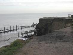
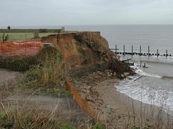
The coast near Happisburgh (pronounced Hayes-Borough) was very eroded, and the path diverted into a field where the previous well-worn path disappeared into the void off the edge of the cliff. On the southern edge of Happisburgh I reached a stretch of tarmac that went literally over the cliff, with only some portable fencing acting as a barrier to prevent people from walking over the edge. This road originally used to go southeastwards along the coast for a couple of miles as far as Eccles, but the road was long-gone. The sea defences end a few hundreds of yards from the south of the village and restart about a mile to the north, and so the village is currently undefended by any modern sea defences and many houses on top of the cliff are in danger of collapse into the sea. This is now a famous case on the viability of defending the coastline versus the obvious costs of such defences. The situation at Happisburgh is obviously not helped by the cliffs, which are quite high and appear to consist of quite loose sand. Indeed two villages, Shipden and Whimpwell, have totally disappeared into the sea over the years. I last walked along this stretch in early 2001, and even in that short period it was easy to see where a couple of buildings were missing, having been lost to the sea.
About seven miles offshore from Happisburgh are the nine-mile long Happisburgh Sands, which are a major navigational hazard for shipping. Many ships have been lost on these sands, and in 1904 so many wrecks were on the beach that Trinity House had to blow them up to clear them. Wreckage from ships still gets washed up today, and after northeasterly gales villages used to scour the beach for items thrown up by the waves. Many of the people who died in these wrecks are buried at Happisburgh Church, which has a 100-foot high tower. These include 119 men from HMS Invincible, wrecked in 1801, 32 men of HMS Peggy, wrecked in 1770, and 12 men of the Young England, which was wrecked in 1876.
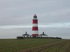
The pretty red-and-white lighthouse standing on the cliffs to the south of the village at Happisburgh had been painted in the television series "Challenge Anneka" many years previously. Apparently despite the fact that they were meant to be doing the painting in two days, they were on site for two weeks that corresponds with other stories that I have heard. It is a very nice lighthouse, looking very symmetrical from a certain angle with the two nice white houses alongside it. It was originally built in 1791 and had a companion low light 400 yards to the north (which was demolished in 1883), and has a range of 17.8 miles and is 94 feet tall.
On the previous trip I bought a history of the Happisburgh and Mundesley lifeboats from the lifeboat station in Happsiburgh. Two things come to mind when I skimmed through this booklet - firstly how much coastal erosion was shown in the maps within the booklet, and the other being the history of the lifeboats. I found it amazing that in the 1860's (when much of the population would never even have seen the sea) the Grocers of England paid for a lifeboat to be stationed at Mundesley, and the Great Eastern Railway Company carried her to Mundelsey from Shadwell in London.
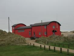
On the prominent red lifeboat station in Caister is a little sign stating 'Caister men never turn back'. This is written for the nine men of he lifeboat who drowned in 1901 when the lifeboat capsized. Only three of the crew survived, and the term has become the motto for the lifeboat station.
I have walked around the coastline of East Anglia much quicker than I did when I walked it before. For instance the section from Hunstanton to Cromer was four walks when I did it in 2001, but on this trip I covered it in two and a quarter. If you take the section between King's Lynn and Cromer, then it is three and a quarter days instead of six. This fact alone shows that I am making good time on this trip. Tomorrow I should be able to get to Lowestoft, and after this I will be on virgin territory once more as I head south along the Suffolk coast.
Directions
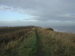
This walk starts off on the sea wall at Rudram's Gap, which runs beside the B1150 road. Head southeast along the seawall, passing Walcott Gap and heading towards Ostend. When the sea wall ends beside a caravan park you have two choices. If the tide is out then you can choose to walk south eastwards towards Happisburgh - but this should only be attempted if the tide is right out as the cliffs at Happsiburgh go out to sea for a long way. If the tide is high then climb up onto the top of the cliffs beside the caravan park and follow the edge of the cliff past some chalets. When the way ahead is blocked turn right to walk through the are of chalets along a rough track until it ends at a T-junction with a surfaced road. Turn right along this road and follow it as it heads southwards for a short distance, with Walcott Church ahead to the right across some fields. Follow the road as it curves to the left. Just before it turns to the right head left down a track beside some new houses back towards the coast and then turn right to reach a path that parallels the coast. Continue southeastwards for about a mile along this cliff top path, passing a coastguard lookout before reaching a caravan park to the northwest of Happisburgh.
Continue on as the path, which has been severely eroded, continues through the caravan park with the tall tower of the church nearby to the right. At the end of the park join a surfaced road for a few yards before turning left down a track that parallels the coast with some condemned huts stubbornly clinging to the cliff top on the left. This track ends at the sea, so turn right up another track with soon ends at a surfaced road. At this road turn left and follow it past a small hotel until it ends at the sea.
Just before it ends at the sea turn right and follow a path through fields saoutheastwards along the cliff edge. This path approaches Eccles, where I deemed it safe to go down onto the beach for the rest of the day.
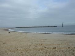
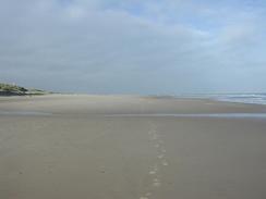
Continue along the beach past Eccles on Sea and towards some large stone structures out at sea. These are a new design of sea defences being tested out, and mark the approach to Sea Palling. Continue along the beach past Sea Palling, passing Winterton Ness as the coastline slowly changes from heading southeastwards to a more southerly direction. As the miles get ticked off the beach passes Winterton-on-Sea, Newport and California before eventually reaching the outskirts of Caister-on-Sea. Continue along the beach past Caister until a large red building appears on the right. This building is the Caister lifeboat station, and there is a car park immediately inland from it.
These directions can be used for the tide conditions in which I approached them; a thigh tide that was going out which left me plenty of time to walk along the coast south from Eccles on Sea. If the tide conditions are different for you then you may have to leave the beach and walk inland; there are very discontinuous paths that allow you to do this. Fortunately south of Eccles on Sea the beach is very wide and there are sand dunes to the landward side that should be easy to get over if the tide does trap you.
Distances
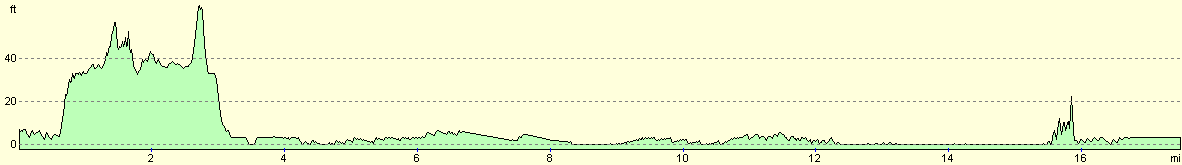
| From | To | Distance (m) | Ascent (ft) | Descent (ft) |
|---|---|---|---|---|
| Rudram's Gap | Happisburgh | 2.2 | 138 | 115 |
| Happisburgh | Sea Palling | 3.6 | 89 | 115 |
| Sea Palling | Winterton-on-Sea | 6.6 | 105 | 108 |
| Winterton-on-Sea | Caister-on-Sea lifeboat station | 5.1 | 102 | 98 |
This makes a total distance of 17.5 miles, with 434 feet of ascent and 436 feet of descent.
For more information on profiles, ascents and descents, see this page
Accommodation
We stayed at a site at Highgate Farm, Swim Road, Runham, Great Yarmouth, Norfolk NR29 3EH. They can be contacted at 01493 368133 and are open all year round. This site cost us eight pounds for the night, and is a reasonable low-cost site that is part of a working farm. It was nice to wake up and see grouse running around outside the van, which was parked on a nice level site in a field.
Disclaimer
Please note that I take no responsibility for anything that may happen when following these directions. If you intend to follow this route, then please use the relevant maps and check the route out before you go out. As always when walking, use common sense and you should be fine.
If you find any information on any of these routes that is inaccurate, or you wish to add anything, then please email me.
All images on this site are © of the author. Any reproduction, retransmissions, or republication of all or part of any document found on this site is expressly prohibited, unless the author has explicitly granted its prior written consent to so reproduce, retransmit, or republish the material. All other rights reserved.
Although this site includes links providing convenient direct access to other Internet sites, I do not endorse, approve, certify or make warranties or representations as to the accuracy of the information on these sites.
And finally, enjoy your walking!
This walk was mentioned in the following routes:
| My walk around the coastline of Britain |
Nearby walks
| # | Title | Walk length (miles) |
|---|---|---|
| 136 | Lowestoft to Caister-on-Sea | 14.4 |
| 155 | Caister-on-Sea to Sea Palling | 12.5 |
| 163 | Sea Palling to Mundesley | 9.4 |
|
|

|