Walk #258: Caister-on-Sea to Gorleston-on-Sea
 |
 |
|
General Data
| Date Walked | 06/11/2002 |
| County | Norfolk |
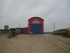
| Start Location | Caister-on-Sea lifeboat station |
| End Location | Gorleston-on-Sea |
| Start time | 08.31 |
| End time | 12.33 |
| Distance | 11.1 miles |
| Description | This was a short walk by my recent standards which was cut short by the awful weather. It mainly consisted of a long walk up the River Yare to the nearest bridge in the centre of Great Yarmouth and then back down to Gorleston, a long walk which only got me a few hundred metres south of where I started. |
| Pack | Today I carried my 30-litre Karrimor HotRock rucksack, which was filled with my packed lunch, waterproof leggings, water bottle and a couple of spare shirts, together with the usual assortment of odds and ends. |
| Condition | I felt rather bad throughout this walk, although I am unsure if this was all to do with the horrible weather rather than anything wrong with my condition. Certainly I had no aches or pains from my feet or legs throughout the walk, which made a change from the last few days, but I did have a dribbling nose and a fuzzy head from nearly the moment that I left the van. When we got to the campsite in the early afternoon I went to bed, and when I got up an hour or so later I had a quite bad stomachache and was feeling even more unclear in my head. I do hope that this is a temporary affliction and not something that will last a long time, as I do not fancy walking a long way feeling as I did today. |
| Weather | Today was probably the worst rainy weather of the walk so far. There was a constant heavy rain, which was strong enough to cause flood warning elsewhere in East Anglia, and with it was a rain that was straight onto my face for the walk along the coast. These combined to make me fairly wet within half an hour of getting out of the van, and unfortunately the rain did not really let up all day. The only good thing that could be said for the weather was that it was quite mild, which meant that I did not get as chilled as I could otherwise could have been. |
| OS map | Landranger number 134 (Norwich & The Broads, Great Yarmouth) |
 |
 |
|
Map of the walk
Maps courtesy of Google Maps. Route for indicative purposes only, and may have been plotted after the walk. Please let me have comments on what you think of this new format. For a detailed table of timings for this walk, please see the table file.
 |
Notes
This was really a walk that I find it hard to say anything positive about. The weather was bad - not just the rain, but the fact that I had a headwind along he coastal section - and I was feeling slightly unwell which did not really help improve my mood. Great Yarmouth itself is not the nicest (although also far from the worst) place in the world, but I find it hard to say anything positive about it in the solid rain in which I saw it today. The worst thing for me was that whilst I was walking along the seafront I was looking for a newsagent where I could but a packet of crisps and I could not find one - most of the shops were amusement shops that had shut for the winter season and the rest were cafés. Eventually I found one near the docks so I nipped in and made my purchases.
The walk today was quite unusual in that I had to walk back on myself for three miles to get over the River Yare. Last time I did this walk (in a reverse direction from Lowestoft) I did not bother doing this and just cut across from the river to the coast near the pier. Walking down and back up the coast added a few more miles on, and unfortunately these were far from being the most scenic miles of the whole walk.
When I got back to the van I discovered that for the first time on this trip many of my photographs had been spoilt my moisture getting onto the lens. I had managed to avoid this except for a few rare occasions on all the previous walks, but now about half the photographs I had taken were blurry. This is doubly annoying as I had not taken as many photographs as I normally do, and therefore have less to use on the website. In particular I wanted to get some photographs of the Nelson memorial, but both of these came out very blurred, which is a great shame. This monument is quite impressive even in the rain, and was built in 1817 as a memorial to Lord Nelson who landed at a jetty in the town after his victories in the battles of the Nile an Copenhagen.
As I was walking in a fairly dejected manner down the road which runs alongside the seafront in Great Yarmouth Sam drove past me in the van. She failed to see me, but I called her on her mobile and pulled over to wait for me. When I reached her we agreed that I would cut the walk short, and instead of walking to Lowestoft I would instead only walk as far as Gorleston-on-Sea. Although I felt bad that for the second time on the trip I was falling well short of a target, given the weather conditions and my general feeling of illness I thought that it was the wise thing. I was determined to walk around the river Yare, as this would give me a straight run down the coast to Lowestoft and beyond tomorrow. Even though I have cut the walk short I still have managed to complete a little over eleven miles, which is not bad for a short day.
As I was approaching Great Yarmouth through the sand dunes I could see little wisps of smoke rising up ahead of me. As I got closer I could see three kids standing by a little patch of Marram grass that was on fire. As I approached they ran away, so I jogged to where the fire was. There was some litter - old newspapers, plastic bags and the like - lying on the ground, and the children had set fire to it. Fortunately due to the rain the fire had not really got hold of the grass, and I stamped out the area and then kicked sand all over it. They were watching me as I did this, and two of them gave me v-signs before turning and running away. This one act probably depressed me more than the rain ever could.
Because this was such a short walk I am now behind schedule, and I will have to walk a long way tomorrow to reach Southwold and be back on schedule. Fortunately the weather forecast states that the weather should be much better, so I may get the opportunity to walk that distance.
Directions
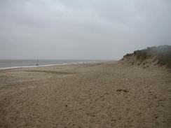
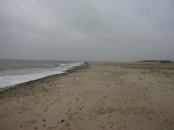
This walk starts off buy the lifeboat station in Caister-on-Sea. Turn right and follow the beach as it heads southwards, with the sea to the left and sand dunes to the right. Follow the beach around until you can see the road that runs alongside the beach clearly through the dunes to the right. At this point angle to the right through the dunes and join the North Drive. You can alternatively continue along the beach if you want.
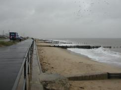
Follow the North Drive as it heads southwards, passing the garish Britannia Pier, a jetty, a sea life centre and a pleasure beach before reaching Nelson's monument on the right. Continue straight on southwards as the area becomes more industrial until you reach the mouth of the River Yare.
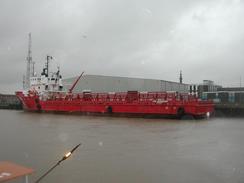
At the river mouth the road curves around to the right to start heading back along the eastern bank of the river. This again passes through a rather industrial area, with lots of ship and docks services companies based along the road. As the road continues on it becomes the A1243, which is followed past the South Quay until you reach Haven Bridge, which is the first bridge over the river.
Turn left to cross Haven Bridge and then follow the road as it passes a Matalan store. Immediately behind the store turn left to head southwards down a road with ship berths on the left. When a dual carriageway road comes in from he right take a road that leads off to the left. This road rises up towards a pub where you can take another road that leads off to the left. This road runs alongside the river until you reach the mouth of the River Yare in Gorleston-on-Sea. At the mouth continue on to the seafront, where the beach can be joined for the next journey southwards. Sam met me on the cliff top road in Gorleston-on-Sea.
Distances
| From | To | Distance (m) | Ascent (ft) | Descent (ft) |
|---|---|---|---|---|
| Caister-on-Sea | Brittania Pier | 2.7 | 10 | 10 |
| Brittania Pier | Bridge over the Yare | 5.0 | 16 | 20 |
| Bridge over the Yare | Goreleston | 2.8 | 82 | 52 |
This makes a total distance of 10.5 miles, with 108 feet of ascent and 82 feet of descent.
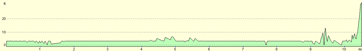
For more information on profiles, ascents and descents, see this page
Accommodation
We stayed at the campsite at Taylors Farm, Corton, Lowestoft, Suffolk NR32 5NZ. They can be contacted on 01502 730241 or 01502 512137. This site cost us six pounds for the night, and is based on a farm with a toilet and shower.
Disclaimer
Please note that I take no responsibility for anything that may happen when following these directions. If you intend to follow this route, then please use the relevant maps and check the route out before you go out. As always when walking, use common sense and you should be fine.
If you find any information on any of these routes that is inaccurate, or you wish to add anything, then please email me.
All images on this site are © of the author. Any reproduction, retransmissions, or republication of all or part of any document found on this site is expressly prohibited, unless the author has explicitly granted its prior written consent to so reproduce, retransmit, or republish the material. All other rights reserved.
Although this site includes links providing convenient direct access to other Internet sites, I do not endorse, approve, certify or make warranties or representations as to the accuracy of the information on these sites.
And finally, enjoy your walking!
This walk was mentioned in the following routes:
| My walk around the coastline of Britain |
Nearby walks
| # | Title | Walk length (miles) |
|---|---|---|
| 136 | Lowestoft to Caister-on-Sea | 14.4 |
| 155 | Caister-on-Sea to Sea Palling | 12.5 |
| 257 | Rudram's Gap to Caister-on-Sea | 17.5 |
|
|

|