Walk #632: A circular walk from Brandon Creek
 |
 |
|
General Data
| Date Walked | 27/11/2004 |
| County | Cambridgeshire, Norfolk |
| Start Location | Brandon Creek |
| End Location | Brandon Creek |
| Start time | 09.25 |
| End time | 14.51 |
| Distance | 17.4 miles |
| Description | This was a nice stroll following the banking of the Little Ouse and various roads and tracks around the Cambridgeshire/Norfolk border. |
| Pack | Today I carried my 30-litre Karrimor HotRock rucksack, which was filled with three litres of water, a spare fleece, waterproofs and various electronic gadgets. |
| Condition | I am fairly tired after this walk, but aside from a blister on one of my little toes I have suffered no ill-effects from this stroll. The undersides of my feet were aching towards the end of the day, but this was only an annoyance and not a problem. |
| Weather | The day was reasonably mild for the time of the year, and although it was mostly cloudy there were occasional glimpses of the sun. It did even threaten to rain and there was little wind, which made it a nice late autumn day for a walk. |
| OS map | Landranger number 143 (Ely & Wisbech, Downham Market) |
 |
 |
|
 |
Map of the walk
Maps courtesy of Google Maps. Route for indicative purposes only, and may have been plotted after the walk. Please let me have comments on what you think of this new format. For a detailed table of timings for this walk, please see the table file.
Notes
It had been my intention to go up to Lincolnshire for the weekend to do some walking, but a late night last night led me to waking up far too late to do the journey up the A1. This was annoying, but fortunately I had a back-up walk planned on the Norfolk / Cambridgeshire border, which I had planned to take in the lowest trig pillar in the United Kingdom. I therefore found myself driving up the A10 past Ely and Littleport, before eventually pulling in to a little car park beside the road about a third of a mile to the south of Brandon Creek.
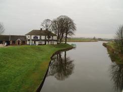
By the time I had got all my kit on, locked the car and set off it was nearly half past nine, about an hour later than I really would have wanted to have been setting off. I climbed up onto the banking that keeps the River Great Ouse from flooding the lower surrounding farmland, and headed north towards the bridge at Brandon Creek. The grass on top of the bank was wet and it did not take long for the bottom of my trousers to be soaking, and that water drained down into my boots. I reached the bridge at the creek and looked down towards the pub to see that there is car parking available; this would have been a much better place to start the walk than the lay-by.
Once across the bridge I took a road that headed southeastwards below the northern bank of the Little Ouse. I soon reached Bank Farm, where the muddy road ended and I had to climb up onto the footpath that runs along the top of the bank, passing a little flat-bottomed workshop boat that was being used by workmen building an extension to the farmhouse. Again the grass was long, and within a short period I could feel my feet getting wet; it is one of the classic examples of when gaiters are useful and, of course, I had left mine at home. I soon reached my first target of the day, the Little Ouse trig pillar, which was situates by a little drain to my left down the bank. This pillar is officially at -1 metres below sea level, and is thus the lowest trig pillar in the UK. I photographed it, recorded the flush bracket number, and then climbed back up the banking to continue the walk.
When I came across a bridge that carried a track over the Little Ouse I used it to cross the river, and started walking through the hamlet of Little Ouse. This was a quiet little village and I resisted the temptation to visit the church, which is situated a short distance away from the road and was hidden by some trees. The next couple of miles followed the road that ran along the southern bank of the river, and when this ended at a farm I rejoined the footpath at the top of the banking. On top of the banking there was an extremely ramshackle barn; one end of it was open to the elements and it was packed to the rafters with all sorts of ephemera and junk. It looked like a fascinating place and I had a quick look inside before I continued on past some fishermen.
The path at the top of the banking was much rougher than it had been, and in once place was blocked by a barbed wire fence that was easy to squeeze under. It was surprisingly tough going through the wet, long grass and uneven ground, and I was relieved when I reached another bridge over the Little Ouse. This was the point where I was due to leave the river, but first I had to continue on southeastwards for about half a mile to reach another trig pillar. Instead of walking along the top of the bank I decided to follow a rough track that ran at the base of the bank; the going here was much easier and I soon found myself at the pillar, which was a short distance away on the side of the flood banking. The pillar was surrounded by vegetation, and the views were quite unusual; people usually think of trig pillars as being on the top of mountains with wide, sweeping mountain panoramas available; here, instead, there was a wide sweeping panorama of the Fens, even from this low point.
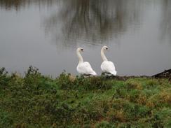
Again I studied and photographed it, before recording the flush bracket number and heading back along the track to the bridge. I stopped on the bridge to look at a family of swans on the riverbank below, and then started walking along the track. This was a fairly boring walk and as I was pushed for time I increased my pace and sped up to about four and a half miles an hour; a pace that certainly tests my stamina. I passed Shrubhill Farm and a short row of housing, before reaching the end of the track at Middle Farm. This farm specialises in turf, and the fields around it had plains of flat, luscious green grass growing on them. Also at the farm were some unusual forklift truck-style vehicles lined up; I studied them but had little idea about how they worked. A short walk eastwards along a good, paved track led me past some houses to another junction, and I joined this to start heading northwards across Feltwell Common.
This track was exceedingly straight, but I quite enjoyed the stroll as I kept up what, for me, was a fast pace. I soon passed a couple of sheeted trailers that were obviously used for sorting some form of vegetables, and not for the first time I was relieved that I did not have to do that for a job every day during harvest season. After a couple of miles this track ended a busy road, and I followed this for a few yards to New Farm, before turning up another track to reach the final trig pillar of the day at Queens Ground. Annoyingly I found this was very close to the track but in a field separated from the track by a deep, narrow drain. There was a wooden sleeper across the drain, but this was visibly rotten and moved alarmingly when I put half my weight on it. I decided that I would chicken out of crossing it, and as there were no other crossing points visible I decided to photograph the pillar from the track.
Annoyed at not being able to touch the pillar I headed back down the track to New Farm. Unfortunately I had to follow the busy road for a few hundred yards, but I soon turned off this to head down quieter roads across the Fens. This meant that the rest of the walk was road walking, and this also allowed me to keep a fairly brisk pace up, although by this time the underside of my feet were aching slightly. The road in this area are characterised by long straights separated by sharp bends, and this road was no exception; the first of these came at Cross Bank Farm, and a couple of miles later there was another right-angle turn at Four Scores Farm. There is not much else for me to report until I reached the A10(T) a couple of miles later; it was just a case of walking along the roads and taking interest in whatever I could.
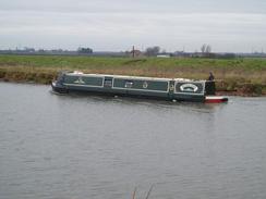
I was relieved when the road ended at the A10(T), where there was an ugly pumping station beside the drain, which looked radically different to the elegant, old pumping house on the other side of the road. This truck me as being a classic example of how modern architecture can be functional, but in being functional certainly loses something over the old Victorian engineering. The A10(T) is a very busy road, but fortunately I only had to walk along it for a few yards as I soon left it to join a footpath that ran along the top of the banking beside the Great Ouse. It was nice to be off roads and on a path for the first time in a few hours, and my mood was further improved by the sight of a narrow boat coming past me. I exchanged pleasantries with the man on the boat, and soon dropped down off the banking to join a road that followed the base of the banking past Horse Fen Farm.
After a kilometre this road ended at the A10(T) once more, and I was left following the wide verge for about a hundred yards to the bridge at Brandon Creek. The pub looked very inviting, but with sopping and sore feet I could only think of getting back to the car and putting my trainers on. On the south side of the bridge I joined the flood banking once again, and followed this back to the car park where I had finished the walk. I was very relieved when I finally reached the car, and I was also quite happy that I had managed to finish whilst it was still light. The walk had hardly been what I could call a classic, but nonetheless it was still an enjoyable walk. Mountains are fine, but low-level (or even below seal-level) walking makes a pleasant change occasionally.
Directions
This walk starts off at a little lay-by about a quarter of a mile to the south of the bridge over the Little Ouse at Brandon Creek. Instead of joining the busy A10(T) for the walk to the bridge, go up the bank immediately to the west of the lay-by and walk northwards beside the river. When you cannot walk along the bank any further, descend down the bank to the right and walk along the wide verge beside the A10(T) for the remaining short distance to the bridge. Before crossing the bridge cross over onto the eastern side of the road, and then cross the bridge. Once on the northern side of the river take a little road off to the right; this curves around to meet the flood bank of the Little Ouse before heading southwards for a little over a kilometre until Bank Farm is reached.
At Bank Farm the road ends so you must climb up the flood bank to the right and start walking along the footpath that runs along the top of it. Route finding is easy for the next couple of kilometres as the path passes a trig pillar before reaching a bridge that carries a track over the river at the northern end of the hamlet of Little Ouse. Here you have a choice; you can continue to walk along the footpath along the northern bank of the river, but I will describe the route that I took. Cross the bridge, and once on the other side turn left and drop down to the road. Follow this as it heads southeastwards beside the flood bank until the road (by now scarcely more than a track) ends at a farm. Climb up onto the bank, and start following the footpath that runs along the top of it southeastwards.
When a bridge carrying over another track is reached, climb up onto it. If you wish to visit another trig pillar then drop down to the right and almost immediately turn left, to follow a rough track southeastwards. This keeps a distance away from the flood bank, before curving around to meet it. A short distance further on (as the track becomes increasingly muddy) there is a trig pillar halfway up the bank to the left. Once you have logged the pillar, turn around and head back towards the bridge. At the bridge cross it, and remain on the track as it curves sharply to the right and descends down. It immediately curves to the left to head northwards, and then after a few hundred yards curves to the right to head on a more easterly course. The track passes a farm at Shrubhill Farm and then curves to the left to head northwards for a mile until the track ends at a T-junction by Middle Farm.
Once at the T-junction turn right and follow another track eastwards for a little under half a mile, passing a series of houses along the way. When another track is met turn left and follow this track as it heads northwards for a couple of miles across Feltwell Common, before it eventually ends at a road. Turn left and follow this road; if you wish to visit the trig pillar at Queens Ground then after a few yards turn right at New Farm and follow a track northwards; the trig pillar is about half a kilometre up the track, situated at the edge of a field to the right, and is clearly visible although less clearly accessible from the track. Once you have visited, return to New Farm and the road. At the road turn right and follow it northwestwards for a few hundred yards; the road is busy and you may find it best to walk along the verge.
When a road junction is met on the left, turn left and follow this road as it heads south for a mile, passing Poppylot Farm on the way. At Cross Bank Farm the road curves sharply to the right to head in a more westerly direction, and after a couple of miles Four Scores Farm is reached. Here there is another right-angle bend, and the road then heads in a more northwesterly direction, passing Sedge Fen Farm before eventually ending at the A10(T) road. This road is very busy, and instead of following it for the couple of miles south to Brandon Creek turn left along the pavement, and when this ends after a few yards cross the road and follow a footpath that heads up to the top of the flood bank of the Great Ouse.
The flood banking can be followed southwards for the next couple of miles (after a while it is possible to drop down onto a minor road that skirts the A10(T) for a time if you prefer road walking to the footpath). When the bank ends, join the verge for the last few yards down to Brandon Creek and the bridge over the Little Ouse. Cross the bridge, and once on the southern side retrace the initial steps of the walk by following the footpath that runs along the top of the flood bank southwards to the lay-by, where this walk ends.
Distances
| From | To | Distance (m) | Ascent (ft) | Descent (ft) |
|---|---|---|---|---|
| Brandon Creek | Middle Farm | 8.1 | 115 | 115 |
| Middle Farm | Brandon Creek | 9.3 | 30 | 30 |
This makes a total distance of 17.4 miles, with 145 feet of ascent and 145 feet of descent.
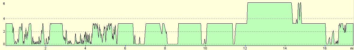
For more information on profiles, ascents and descents, see this page
Disclaimer
Please note that I take no responsibility for anything that may happen when following these directions. If you intend to follow this route, then please use the relevant maps and check the route out before you go out. As always when walking, use common sense and you should be fine.
If you find any information on any of these routes that is inaccurate, or you wish to add anything, then please email me.
All images on this site are © of the author. Any reproduction, retransmissions, or republication of all or part of any document found on this site is expressly prohibited, unless the author has explicitly granted its prior written consent to so reproduce, retransmit, or republish the material. All other rights reserved.
Although this site includes links providing convenient direct access to other Internet sites, I do not endorse, approve, certify or make warranties or representations as to the accuracy of the information on these sites.
And finally, enjoy your walking!
Nearby walks
| # | Title | Walk length (miles) |
|---|---|---|
| 3 | Littleport to Downham Market | 14.0 |
| 54 | Ely to March | 22.9 |
| 169 | Shippea Hill to Littleport via Ely | 15.6 |
|
|

|