Walk #633: A circular walk from Orwell, including Wimpole Hall
 |
 |
|
General Data
| Date Walked | 28/11/2004 |
| County | Cambridgeshire |
| Start Location | Orwell |
| End Location | Orwell |
| Start time | 09.35 |
| End time | 15.09 |
| Distance | 15.8 miles |
| Description | This was a pleasant walk, taking in Wimpole Hall and various villages in this southwestern corner of Cambridgeshire. |
| Pack | Today I carried my 30-litre Karrimor HotRock rucksack, which was filled with three litres of water, a spare fleece, waterproofs and various electronic gadgets. |
| Condition | I am fairly fatigued after this walk, and the little toes on both of my feet are aching and possibly blistered. Aside from my feet my legs and shoulders feel fine, and I could be in much worse shape. |
| Weather | The day started off cloudy with occasional breaks in the cloud that allowed me to see the sun. After a couple of hours, however, it started to drizzle, and after another couple of hours this became rain. It was not a cold day, and this meant that I really did not mind the rain too much. |
| OS map | Landranger number 154 (Cambridge & Newmarket, Saffron Walden) and Landranger number 153 (Bedford & Huntingdon, St Neots & Biggleswade) |
 |
 |
|
 |
 |
|
Map of the walk
Maps courtesy of Google Maps. Route for indicative purposes only, and may have been plotted after the walk. Please let me have comments on what you think of this new format. For a detailed table of timings for this walk, please see the table file.
 |
 |
|
 |
Notes
It has been some months since I last walked for two days in a row, and this weekend looked like no exception. I did a walk on the Norfolk / Cambridgeshire border yesterday, and due to the dreary weather forecast for today I was tempted to give a walk a miss. My alternative to walking, however, was to go into work and battle with Microsoft Word, and when I woke up there were some sunny patches in the sky. I therefore got my local maps out and started looking for a nice local walk. After a short period I settled on doing a walk in southwest Cambridgeshire, with the aim of visiting three trig pillars.
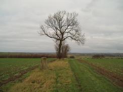
This walk was very local to me, and it did not take me long to get to get to the start of the walk at Orwell, which is just off the A603 road. In the village there is a little car park that would be impossible to find if it were not for a helpful sign, and I parked there, got my boots and pack on, and headed down to the road. Initially I headed out of the village along a road, but shortly after leaving the village I turned northwards along a track that led up Cracknow Hill. This was an enjoyable walk, and I stopped halfway up just beyond a patch of trees and took a rather frightening photograph of myself.
The trig pillar was soon reached, and I duly logged this before going a few yards further on. From here, the top of the hill, I could clearly make out the Mullard Radio Observatory, and a large dish that is part of that complex. It was a fascinating sight, and one that I would continue to see on and off for the next hour. My next target was a pillar further west, and so I decided to walk along a field boundary to the A603 road, and then downhill along that (fortunately the verges were wide and gave me an easy off-road route) until I reached a track leading off to the right.
This track took me towards Rectory Farm, although before this was reached I turned off and followed a footpath that headed up Thorn Hill. A bridleway runs along the crest of the hill, and this made for a nice walk as I headed towards the next trig pillar of the day. On the OS map this was marked as being at the junction with the Harcamlow Way, a 141-mile long figure of eight long distance path between Harlow and Cambridge (Harcamlow stands for HARlow-CAMbridge-harLOW). I reached the junction but could not see the pillar; I walked on a few yards and soon found it behind a low chain-wire fence. The fence was easily climbed over, and I soon logged the pillar.
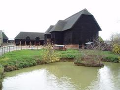
The track down to Old Wimpole (following the Harcamlow Way) was quite muddy, and I soon had big splashes of mud on the side of my trouser legs. When I reached the farm at Old Wimpole I met some people out for a walk; they looked at my muddy legs with dismay, but I explained that I attract mud and that if they were careful it would not be too bad. Walking on, I passed an attractive little cottage before reaching a minor road outside Home Farm. As I reached the road a horse and carriage came past; an unexpected sight that made me look twice. Home Farm was quite nice with some attractive barns, and I took some photographs before taking a concessionary footpath that led across to the driveway leading to Wimpole Hall.
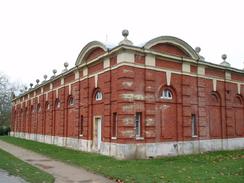
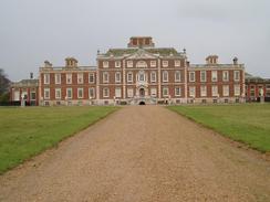
My first sight of Wimpole Hall was the stable block, an imposing red brick building that was grand enough to be a stately home in its own right. This was built in 1852 to a design by H.E. Kendall, and I stopped for a minute to look at some of the fine detailing, something you rarely see on modern buildings. I followed the road around to the front of the block to the main entrance into the National Trust site. Here the cart and horses were poised, looking for another load of punters for the ride to Home Farm. I also got my first sight of the main house, a stately pile that is a superb example of its type. I wished that I had time to have a look around, but with the early evenings and my muddy condition I was hardly in an ideal position to do so. The Hall was first built in 1643 but was rebuilt extensively in the 1740 to 1895 period by such august architects as James Gibb, Henry Flitcroft and Sir John Soane.
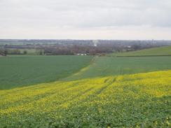
A surfaced track lead southwestwards towards the A1198 Ermine Way, and as I walked along it I could not prevent myself from taking many photographs of the frontage of the hall. A little way to my left was the South Avenue, a double row of elm trees that had an interesting history - in the Second World War they were used to hide B17 Flying Fortress Bombers from the 323rd Bomber Squadron, based ay the nearby Bassingbourn airfield. It was hardly the place that I would have expected bombers to be found, and I mused on this fact as I walked to the end of the track. It had started to drizzle, although this was not heavy and I decided not to put my coat on, instead letting my fleece soak up the light drizzle.
The gates guarding the end of the track from the A1198 road were nice enough, but what really interested me were the carvings on top of the pillars, which seemed to me to be quite lifelike. I photographed these and headed on, past the church in Arrington and along the road to Croydon. I made a little diversion to Croydon Church, which was nice but nothing particularly special, and then headed along the road through the village. My next target was the trig pillar on the northern side of the village, and I found a series of footpaths that led me towards it. As I walked along the last path towards it I scanned the hedge to my left for it; unusually the pillar was standing away from the hedge and not embedded within it, which seems to be the usual position I find them in. I photographed it and then headed along another footpath down the hill to the road in the village.
I had to backtrack slightly to gain access to another footpath that headed southeastwards from the village towards the B1042 road. Initially this led across a newly planted field, and I found it extremely hard to find the correct route across. The next field was ploughed and in a much worse state, and so I decided to follow the field boundary around it. Despite this thick, clinging mud became attached to my boots, increasing their weight and making each step more of a struggle. This was highly annoying, and I could not wait to get to the road. I passed a little pond with a child's swing in it; a strange sight that amused me, before I eventually reached the B1042 road by Valley Farm. This was a good way east of where I should have been, so I trudged westwards along the road, shuffling my feet to try and remove as much of the mud that was still attached to them as I did so.
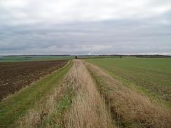
The next stretch of path was easier to follow, and although my boots soon became clogged with mud once again I soon found myself walking past a farm and some light industrial units to the road in Wendy. I joined this road, and by this time the rain was falling even more intently, and I decided that it was time to put my coat on. As soon as I did so I felt happier, and as the rain began to fall more heavily I perversely cheered up even more. I soon reached the A1198 once again, and I had to walk along this southward for a few hundred yards to reach the Harcamlow Way once again. This followed a track southeastwards across fields towards Whaddon, and as I walked along it the rain became drizzle once again and I started to overheat. I was tempted to take my coat off, but a close study of the clouds overhead showed that it could bucket down again at any time.
Whaddon Church was surprisingly large for such a small village, and I soon found myself leaving the village along a footpath that headed northeastwards past Hoback Farm towards the River Cam. Before I reached this I had to negotiate some fallen trees before eventually reaching a small footbridge over the river. This far upstream the Cam was more of a stream than a river, and I found myself wondering how long it would take the water running along it here to reach the sea at Kings Lynn. On the northern side of the river was a golf course, which seemed deserted until I came across three young men who were walking to one of the holes. We exchanged pleasantries, and I was quite relieved to find that I was not the only person mad enough to be out in the rain this afternoon.
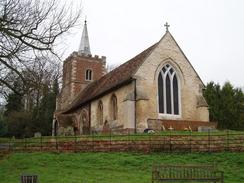
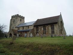
Once I reached the edge of the golf course the footpath continued on in a rough northerly direction, eventually swinging northwesterly and ascending a small hill. Near the top of the hill at rack was met, and I turned to the right and followed this downhill past Grove Farm to the road on the southern side of Orwell. I was quite tempted to go into the pub in the village for a drink as it looked most inviting, but I was very muddy, it was getting dark and I still had not completed the walk. When I reached a road junction by the attractive church in the village I turned right and walked past some beautiful thatched cottages back to the car park and the end of the walk.
Although visiting trig pillars seems a rather silly pursuit, I am finding that it leads to some interesting walks. Planning walks to incorporate trig pillars leads me to go to places that I would not normally visit, and many of these are turning out to be surprisingly good. Cambridgeshire is not a county that springs to anyone's mind when it comes to good walks, although the ones that I have done over the last couple of days, whilst not classic, have been enjoyable enough.
Directions
This walk starts off at the car park in the village of Orwell, which is just to the east of the church and reached by a half-hidden track off the road through the village. Leave the car park and walk down to the road, and then turn left to walk eastwards out of the village. The houses soon end, and a farm is passed on the right before a gateway on the left allows you to access a track that heads northwards up Cracknow Hill. This track is not a public right of way, but the going is easy as it climbs up the hill for a little under a kilometre and, at the top, Orwell trig pillar is reached.
Continue on past the pillar for a short distance until it ends at a patch of scrubland and trees. Skirt past this, and then turn left to follow the edge of a field westwards to the A603 road. There is no fence or hedge between the field and the road; simply drop down to the verge at the side of the road, turn left, and start walking southwestwards down the hill. The road is quite busy so you may find it best to keep to the verge. After nearly a kilometre a track leads off to the right; turn down this track and follow it as it heads northwestwards towards Rectory Farm.
When a gate is reached about halfway along the track turn right and start following a footpath that heads off northeastwards up Thorn Hill. The path follows a field boundary to the right, and when the crest of the hill is reached a bridleway and hedge is reached. Turn to the left and start following the bridleway as it heads northwestwards; you can choose to walk along either side of the hedge; I chose the southern side. After a mile a crossroads with the Harcamlow way is reached by a water board compound; the next trig pillar is a short distance ahead within the compound.
At the crossroads turn left and start following the Harcamlow Way southwestwards It soon joins a track that heads down, passing Cobb's Wood Farm and Old Wimpole before reaching a road opposite New Farm. Turn left along this road for a few yards and then once clear of the farm buildings turn right along a concessionary footpath, which heads southwestwards across a couple of small fields to reach the main access driveway leading to Wimpole Hall. When the driveway is met join it and follow it as it heads westwards towards Wimpole Hall. When the main car park is reached continue straight on, passing directly by the side of the imposing stable block.
Continue on along the track as it heads on westwards, parallel to but some way from the frontage of the main house, of which you get some impressive views. The track soon curves to head southwestwards across the parkland, before it eventually ends at a large gateway that leads onto the A1198. There is a pedestrian gateway to the left of the main gates that can be used to gain access to the A1198 road. Turn to the left along the A1198 road for a few yards, and then cross the road and take a road that leads off to the right. Initially this road curves around, but after it has passed Arrington Church it settles on a southwesterly course towards the village of Croydon.
Follow the road into the village of Croydon; once past the public house on the right turn right down a footpath that heads uphill to the northwest. Once on the top of the hillside it meets another footpath; turn left and follow this southwestwards for a hundred yards before turning left to join another footpath that heads in a rough southeasterly direction downhill, passing a trig pillar in the hedge. Continue on down this path until it meets the road once again in the village. Turn left and walk back northeastwards along the road; just before the pub is reached turn right along a footpath. This heads southeastwards across fields; I found it hard to find on the ground and headed up heading in too much of an easterly direction, and came out onto the B1042 road beside Valley Farm. Take care not to make the same mistake as I did
Once the B1042 is reached (hopefully in the correct place), cross it, and then continue on along another footpath that heads southeastwards towards the village of Wendy. When patches of scrub trees are reached the path turns to the right to walk parallel to these until a bridge over a stream is reached. Turn left to cross this bridge, and then continue on past a little farm and some industrial units to reach the road in Wendy. Turn left and start following the road northeastwards, passing a little chapel before leaving the village. Continue on along the road for about a mile until it ends at the A1198 Ermine Street a short way to the south of Wimpole Lodge.
Turn right and start walking south along the A1198; it is quite a busy road, so it may be best to walk on the verge. Walk past a farm on the left, and then turn left along the Harcamlow Way, which follows a track, that heads through a farmyard before curving to head in a southeasterly direction. The track is easy to follow as it heads southeastwards for a couple of miles until it ends at a bend in a road in the village of Whaddon. At the road turn left and walk eastwards past the church until a sharp right-hand bend is reached. Here leave the road and turn left, walking along a track through the yard of a steel fabrication firm.
After the yard leave the track and turn right to follow the footpath as it heads in a rough northeasterly direction, passing to the north of Hoback Farm before coming to a little footbridge over the River Cam. Cross the bridge, and once on the other side carefully follow the signs northwards across a golf course. Once the golf course ends the footpath starts to veer more to the left, and eventually takes a northwesterly course before reaching a track to the southwest of Grove Farm. Turn right, and follow the track as it heads northeastwards past Grove Farm before ending at a bend in a road in Orwell.
Continue straight on along the road as it heads northeastwards, passing the village pub on the left. When the road ends at a T-junction beside the church turn right and start walking eastwards along the road; the car park where this walk started is situated along a track a couple of hundred yards away along this road.
Distances
| From | To | Distance (m) | Ascent (ft) | Descent (ft) |
|---|---|---|---|---|
| Orwell | Croydon | 6.7 | 404 | 357 |
| Croydon | Whaddon | 5.3 | 161 | 258 |
| Whaddon | Orwell | 3.3 | 108 | 58 |
This makes a total distance of 15.3 miles, with 673 feet of ascent and 673 feet of descent.
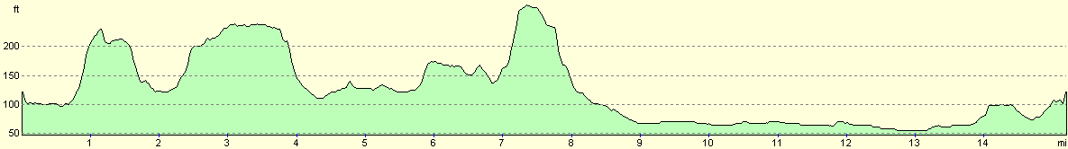
For more information on profiles, ascents and descents, see this page
Disclaimer
Please note that I take no responsibility for anything that may happen when following these directions. If you intend to follow this route, then please use the relevant maps and check the route out before you go out. As always when walking, use common sense and you should be fine.
If you find any information on any of these routes that is inaccurate, or you wish to add anything, then please email me.
All images on this site are © of the author. Any reproduction, retransmissions, or republication of all or part of any document found on this site is expressly prohibited, unless the author has explicitly granted its prior written consent to so reproduce, retransmit, or republish the material. All other rights reserved.
Although this site includes links providing convenient direct access to other Internet sites, I do not endorse, approve, certify or make warranties or representations as to the accuracy of the information on these sites.
And finally, enjoy your walking!
Nearby walks
| # | Title | Walk length (miles) |
|---|---|---|
| 10 | Waterbeach to Great Chesterford via Cambridge | 21.0 |
| 96 | Great Chesterford to Royston | 16.6 |
| 121 | Royston to Hitchin | 17.3 |
|
|

|