Walk #634: A circular walk from Rowsley to Baslow
 |
 |
|
General Data
| Date Walked | 04/12/2004 |
| County | Derbyshire |
| Start Location | Rowsley |
| End Location | Rowsley |
| Start time | 08.28 |
| End time | 15.00 |
| Distance | 17.4 miles |
| Description | This is a lovely walk taking in the hills on the western and eastern side of Chatsworth. |
| Pack | Today I carried my 30-litre Karrimor HotRock rucksack, which was filled with three litres of water, a spare fleece, waterproofs and various electronic gadgets. |
| Condition | I am quite tired after this walk, which is not surprising as it is the most strenuous walk that I have done for some time. I have no blisters, and if I had a rest I could probably have continued on a fair bit further. |
| Weather | The weather today was not too bad, with overast skies but fortunately no sign of any rain. It was not a cold day and there was not much of a breeze, and towards the end of the day there was some gaps in the cloud and the sun made an appearance. |
| OS map | Outdoor Leisure number 24 (The Peak District - White Peak Area) |
 |
 |
|
 |
 |
|
Map of the walk
Maps courtesy of Google Maps. Route for indicative purposes only, and may have been plotted after the walk. Please let me have comments on what you think of this new format. For a detailed table of timings for this walk, please see the table file.
 |
 |
|
Notes
I found myself up in my native Derbyshire this weekend, and so I thought that doing a walk in the Peak District was a good idea. I was unsure until this morning about which walk I was going to do, but I soon decided to do a walk along the gritstone edges to the east of Chatsworth. Not only have I not walked along these edges before, but it would also link some of my previous walks; ones in the Rowsley area with one that I did earlier in the year along the gritstone edges north from Baslow. I therefore found myself setting off before dawn along the roads that led to this eastern side of the Peak District.
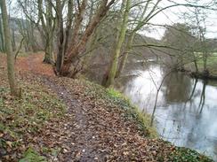
When I pulled up in the car park at the Peak Village factory outlet complex I was surprised to see that mine was virtually the only car there - it was half eight, and I would have thought that at the very least cars belonging to staff would be there. Dismissing these thoughts I put on my rucksack, locked up the car and headed off on the walk. To get up to the edges I had decided to head south for a little over a mile to Northwood, where convenient roads and paths could get me onto the moorland. This took me along the a href = "http://www.nationalheritagecorridor.org.uk/">Derwent Valley Heritage Way, a recently opened long-distance path from that runs from the source of the Derwent down to the point where it meets the Trent.
This stretch of the trail took me on a path that skirted the river through some first-generation woodland, which marks the site of the old Rowsley marshalling yard. This was a massive complex before is hut slightly before the railway line in 1968, and as I walked I could see occasional well-hidden traces of this industrial past; the path weaved past and over large sections of brick wall, now disguised by mud and overgrowth, and over relics such as a large circular pit that was used to provide water from the river for locomotives. It was an enjoyable if slightly muddy walk, and I was annoyed when the path joined the access road that leads to Peak Rail's main site at the old Rowsley locomotive sheds.
I did not get to see much of the site, because as soon as I reached the buffer stop marking the end of the line (which I had painted back in 1995) I turned off and walked up a very short lane to the A6 road in Northwood. A handy pedestrian crossing helped me cross the road without any bother, and I then came across something that has always amused me; set back slightly from the road is a small shop that acts as a flour wholesaler - a strange sight nowadays. Next to the shop a road led up the hillside, and it was a steep climb up - evidently it was in times past, as near the top there were a couple of horse troughs embedded in a stone wall beside the road. This area was largely developed along with the rest of Darley Dale as part of the Stancliffe Estate (Stancliffe House is nearby), by Sir Joseph Whitworth, the famous Victorian mechanical engineer and a hero of mine.
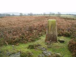
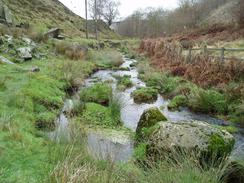
Shortly after this the path left the road and started heading up a gentler slope, running beside a little stream before eventually breaking out onto the open moorland. The path became a track, and I soon found myself diverting off this and climbing over a gate to gain access to the Fallinge trig pillar. The views from the pillar were quite nice, and I enjoyed seeing red skies to the west. As I still had a long way to walk I did not hesitate for too long, and set off across the moorland to rejoin the track before it eventually hit a road. Here I had a choice; I wanted to walk across the moorland above Fallinge edge, but this is not a right of way. The alternative was to walk down the road and take a footpath that ran via Fallinge to Beeley Plantation.
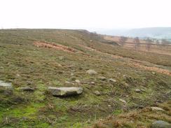
In the end I decided to walk across the moorland; technically this was trespassing but this slightly increased the appeal; when I had initially planned this walk a couple of months ago a quick trawl of the net showed that there were few, if any, walks on the net that passed over this edge, whereas those further north have motorway-style paths over them. I therefore left the road and headed northwards towards the disused Bond's Quarries. Here I came across a barbed wire fence right at the top of the quarry. I had to carefully cross this, but I did not do it carefully enough, and got a cut on my right hand for my trouble. I sucked the blood off the cut as I walked along the edge, where progress was hard due to the trackless terrain. The heather came up to the middle of my calf in places, and this nicely disguised the boulders that lay underneath.
I took my time getting to Raven Tor, and I then left the edge to make my way northeastwards across the moorland with the intention of joining a track. This was easier going as I could use what few little tracks there were as I headed in the general direction of the track. Once on the track I sped up, and soon found myself at a road. Nearby is Fallinge Edge Ring Cairn, a turf cairn which I did not feel that I had time to visit. Once at the road I started following another road eastwards, aiming for the Harland South trig pillar. I soon reached this but could not find a convenient way over the wall that separated the road from the moorland. As I walked along looking for a way over a cyclist stopped to chat to me - it turned out that he was 78, and cycled over 8,000 miles a year. I had a nice chat with him, and I found myself hoping that I could still be that fit in fifty years time.
Once he had gone I found a low stretch of wall and I managed to get over, and I made my way for the short distance to the trig pillar. The views from here were nice, and I studied them for a while before moving on, heading northwestwards across the trackless Beeley Moor. On the way I passed a series of shooting butts that were fortunately not occupied. Despite the rough terrain I made good time, and I soon found myself at a rough, muddy track that runs from west to east and acts as the boundary between Beeley Moor to the south and Gibbet Moor to the north. I joined the track and followed it for a short distance westwards to Hob Hurst's House, an unusual rectangular prehistoric burial mound. I could not help but climb over the stile into this structure, and although it was easy to make out the ditch and central area the all-encompassing heather and bracken spoilt the situation somewhat.
After exploring for a short period I pulled myself away and started following a track that skirted around the western edge of Gibbet Moor. I had walked across the centre of this moor nearly fifteen years earlier whilst on a night navigation at school, and my memories of the experience dissuaded me from walking across it today. The track made for a more boring but easier walk, and I soon found myself rounding the northern side of the moor. It had been my intention to follow the track down to the A619 road, and then follow that past Robin Hood (yes, there is such a place) to Baslow. However as I neared the road I came across a signpost pointing across the moor that stated that it led towards Robin Hood. As I did not fancy walking along the busy road I opted for this route instead, and I soon found myself dropping down into a steep-sided valley with the road high up to my right.
The path was surely a better route than the road, and I enjoyed the walk along it, although I became slightly alarmed when I realised that I had walked past the Robin Hood pub. I was relieved when I found a sign stating that the path led on to Baslow, and after joining a track for a short distance and passing some impressive rock formations near the saw mill I entered Chatsworth Park. This park covers 1,00 acres, and much of it was designed by 'Capability' Brown in the 1760's. A large ladder stile made of stones led me over the wall and into the park, and I soon headed downhill across the parkland, which made a big change from the ough moorland walking of earlier in the day. The path passed a beuatiful gate and lodge complex before ending at a road, and I followed this to the car park in Baslow, which meant that I had connected up with my previous walk northwards from the picturesque Peak village.
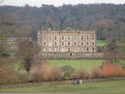
I retraced my steps slightly to get to the eastern side of a wide stream, crossing a pretty stone bridge on the way. From here I followed a broad path that led south beside the stream, and when the path re-entered Chatsworth Park I was surprised to find the most unusual stile I have ever encountered; a large cylindrical one with a pivot above my head, which apparently was designed to allow wheelchairs through. Despite being a nice Saturday afternoon the path was not too busy, and I enjoyed me walk through the park, passing the White Lodge before reaching Queen Mary's Bower, a spectacular stone structure surrounded by a drained moat. It is named after Mary Queen of Scots, who was allowed to use the Bower as a garden during her captivity in the 1570's. I resisted the temptation to climb up the steps onto the top of the Bower, and instead walked around the moat, which had some wooden structures in it, as the park is used for International Horse trials. The House itself was very visible, and it is a magnificent structure, although I would not advise going around it in muddy walking boots!
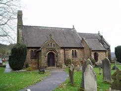
A nice bridge took me across the River Derwent, and I then started climbing over a little hill to reach the village of Edensor (pronounced Enzor). The village used to be situated closer to the hall, but the 4th Duke of Devonshire demolished the old village, and it was only recreated in the 1839 by the 6th duke. It is a fascinating planned village, and I enjoyed walking around the church. Unfortunately I did not see the graves of another of my heroes, Sir Joseph Paxton, or that of Kathleen Kennedy, JFK's sister. She was the widow of the 10th Duke's eldest son, who was killed in a plane crash in 1944.
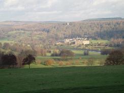
After leaving the churchyard I wandered around the village for a few minutes studying the fascinating architecture, before heading up some well-worn and slippy steps that led onto a field above the village. The path was easy to follow as it headed across the fields, skirting a small patch of woodland before leaving Chatsworth Park and entering New Piece Wood. The track headed uphill for a short distance before leaving he wood, and I started heading towards the farm at Calton Houses. The path to Rowsley lay past the farm, but as I had plenty of time I decided to make a diversion, and so I joined another path that headed westwards across Calton Pastures. Near a pond I joined another path, which headed southeastwards back across the pasture. The path passed a couple of tumuli before I made a little diversion uphill to visit Calton Pastures trig pillar. As I looked back from this pillar the sun came out, and I could the hills over to the east bathed in beautiful sunlight, a magnificent sight that I could not help but bask in.
Eventually I pulled myself away from the view and started heading back towards the path, which passed another large tumulus before entering an area of woodland. Here the path joined a track and it became far muddier as it started descending downhill towards Rowsleymoor Wood. On the way down I came across a couple of men who were on a camping trip, and I had a pleasant chat to them before heading on down the hill. When I reached a track junction I joined a route that I had walked earlier in the year, and I was pleased to see that the muddy path was well and truly behind me. On the way down I was passed by a series of cyclists coming uphill, and I could not help but make smart-alec comments to them as they passed me.
The track became a road, which headed south towards the little Rowsley Church. It then passed the abutments of a long-demolished rail bridge, before eventually reaching the A6. This took me over the River Derwent, with a large rail viaduct visible through the trees a short distance upstream, and I soon found myself passing through the car park of the Grouse and Claret pub to reach the car park at the Peak Village shopping centre. The contrast to this morning was marked; when I had left mine had been one of only a couple of cars there, whereas by this time in the afternoon it was virtually filled with cars of people doing Christmas shopping. After dumping my rucksack into my car and changing from boots into trainers, I decided that I would join them, and a very pleasant half-hour followed - a most unusual end to a day's walking.
Directions
This walk starts off in the car park of the Peak Village shopping outlet, a small shopping village nestling between the A6 and B6012 in Rowsley. Lave the car park by heading north, and just before the road inside the centre swings to the left take a path that leads through a small gate and heads across some grass to the car park of the Grouse and Claret pub. Walk through the small car park to the A6, and the carefully cross the busy road. Once on the other side turn left and walk eastwards along the road for a short distance, before taking the first road to the right. This road rises up slightly, passing a little car park on the right before reaching a large industrial unit.
Immediately before the industrial unit is reached a path leads off to the right, squeezing between the fence to the left and the River Derwent, below to the right. This path is the Derwent Valley Way; follow it as it heads southwards through woodland for a little under a mile, always keeping the river close by to the right through the trees. Eventually the path skirts a roundabout in the left, and then shortly afterwards heads to the left to join a rough track (the access road leading to Peak Rail's Rowsley site). When the track is reached turn right to head over a little bridge, and continue on south along the track until the access gates to the main Peak Rail site are reached.
Do not enter the site but instead turn left, to walk up a short lane to the A6 road at Northwood. Turn left and walk for a few yards to a pedestrian crossing and cross the A6, and then continue on until a road junction is reached on the right next to a small shop selling flour. Turn right up this road, called Northwood Lane, and follow it as it heads steeply uphill. It turns sharply to the right and then to the left before continuing eastwards uphill. As it nears the top of the hill it makes another sharp turn to the right, and a short distance afterwards turn left along Lumb Lane. Lumb Lane soon ends near some houses; take a footpath that leads off to the right, following a stream uphill northeastwards through an area of woodland called Stitch Plantation.
The path soon emerges from the woodland and becomes a track. It turns to a more northerly course, and then shortly afterwards turns back to a northeasterly course; if you wish to visit Fallinge Edge trig pillar then there it is situated in the adjacent field to the right. If not then continue on along the track as it passes over Little Bumper Piece and ends at a road. Here you have a choice to make; the route I describe involves trespass over moorland, so if you are not happy with doing this then it may be wise to use a longer, alternative route via Fallinge down the road to the left. If this is okay, then cross the road and started heading northwards across trackless moorland. Progress is rough, but fairly soon a barbed wire fence is reached guarding Bond's Quarries.
Carefully cross this fence and then skirt the top of the long-disused and overgrown quarry, before settling on a northerly course following Fallinge Edge. The going is quite rough, and the route takes a more northeasterly course as it heads towards Raven Tor. Here I left Fallinge Edge, and took a more easterly course across the moorland to reach a track at about SK 289675. Once on the track turn left and start following it as it heads northwestwards and then northeastwards before ending at a road. Turn right along this road for a few yards until a road junction is reached, and then turn left to follow another road eastwards for about half a mile. When the road ends at another junction turn left, and follow this road as it heads uphill in a rough northeasterly direction.
At the top of the hill, and before the road started dropping downhill, carefully cross the wall to the left and walk across the moorland the short distance to the Harland South trig pillar at SK300681. From the pillar take a northwesterly course, crossing Beeley Moor; take care not to head too far west towards Harland Edge. After about a mile a rough track running from west to east is reached; turn left and join this and follow it as it heads westwards for a few hundred yards before a fence guarding Hob Hurst's House is reached. Here turn right and walk across the moorland for a short distance to join another, better quality track, which head northwestwards, slightly away from and area of woodland to the left.
This track soon takes a more northerly course and starts to diverge away from the trees on the left; to the right is the broad expanse of Gibbet Moor. A couple of kilometres from Hob Hurst's House a little barn is reached; here the track turns to the right and starts heading in a more northeasterly direction. Shortly after the track crosses a stream turn left at a footpath marker and follow a distinct but narrow concessionary path that heads north across the moorland for a short distance before dropping down into a steep-sided valley below the B6050 road. Once at the bottom of the valley turn left and follow the path as it heads northwestwards under a set of overhead lines; the path soon changes to a more westerly course. Once a pipeline across the stream to the right is reached the path heads up a slight slope to the left and then heads westwards once again.
A track is soon joined, and this can be followed as it heads westwards past some impressive rock formations. Do not divert off this main track, and once it ends at a wall guarding Chatsworth Park climb the wall using the built-in stile. Once on the other side follow a clear path that heads downhill to the west, passing close to an impressive gateway and Park Lodge before reaching some trees. Go through a small gate and through a garden to reach an access driveway; turn left along this and follow it as it curves to the right before ending at a public road. If you wish to visit the centre of Baslow and a large car park (an alternative start and end point for this walk) then continue straight on; otherwise just before a bridge over a stream is reached turn left to follow the eastern bank of the stream southwards.
The broad and well-made path re-enters Chatsworth Park using an unusual stile and then continues on southwards for another couple of kilometres, passing the White Lodge before eventually reaching the impressive Queen Mary's Bower. Pass this and then turn right to join a road that rises up the adjacent bridge over the River Derwent. Cross the bridge, and once on the western side of the river join a footpath that heads off slightly to the right, climbing uphill to the southwestwards before turning to head downhill to the west towards Edensor Church. When the B6012 is reached cross it and then enter the main gateway into the village. Pass the church to the left, and shortly afterwards take a footpath that heads up some stone steps to the left.
The steps end at a field, but the footpath is easy to follow as it heads slightly west of south up the gently sloping hillside for a kilometre towards New Piece Wood. When the wood is reached cross the large stone wall using the in-built stile and join a track that curves steeply uphill through the narrow woodland. Once the track emerges from the southern side of the wood continue on downhill to the south for a few yards until a footpath junction is reached before the farm at Calton Houses; turn to the right and follow this new footpath as it heads in a rough westerly direction across Calton Pastures.
The path skirts a pond to the right before crossing a fence to the left. From here another footpath heads off to the left, taking a more southeasterly course across Calton Pastures. Just before a fence is reached turn right to walk up to Calton Pastures trig pillar, which is built into a stone wall at SK 23776 68178. Return down to the path, and continue along it southeastwards for a short distance as it passes a tumulus on the right and then meets a bridleway. Turn right along this bridleway and follow it as it almost immediately enters a patch of woodland and turns to head in amore southeasterly direction.
The path follows a broad but very muddy track as it heads downhill past Beech Square Plantation; it soon curves to take amore southerly heading downhill before eventually ending at a junction with another track. Turn left along this track for a few yards to another junction, and then turn left to follow another track eastwards that heads through the woodland at Bouns Corner. When it emerges from the woodland the footpath turns sharply to the right and heads downhill for a short distance along the eastern edge of the woodland, before joining a track that heads southeastwards to the end of a road in Rowsley. Turn right down this road and follow it downhill to the south, passing Rowsley Church before ending at the A6(T) by the Peacock Hotel. Turn left and follow the A6 northeastwards as it crosses the River Derwent on a bridge; shortly after this turn left to walk through the car park of the Grouse and Claret pub. In the car park a footpath leads off across a small area of grass to reach the car park of the Peak Village shopping outlet, where this walk started and ends.
Distances
| From | To | Distance (m) | Ascent (ft) | Descent (ft) |
|---|---|---|---|---|
| Rowsley | Baslow | 10.7 | 1165 | 1119 |
| Baslow | Rowsley | 6.7 | 830 | 876 |
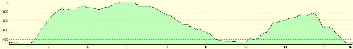
This makes a total distance of 17.4 miles, with 1995 feet of ascent and 1995 feet of descent.
For more information on profiles, ascents and descents, see this page
Disclaimer
Please note that I take no responsibility for anything that may happen when following these directions. If you intend to follow this route, then please use the relevant maps and check the route out before you go out. As always when walking, use common sense and you should be fine.
If you find any information on any of these routes that is inaccurate, or you wish to add anything, then please email me.
All images on this site are © of the author. Any reproduction, retransmissions, or republication of all or part of any document found on this site is expressly prohibited, unless the author has explicitly granted its prior written consent to so reproduce, retransmit, or republish the material. All other rights reserved.
Although this site includes links providing convenient direct access to other Internet sites, I do not endorse, approve, certify or make warranties or representations as to the accuracy of the information on these sites.
And finally, enjoy your walking!
Nearby walks
| # | Title | Walk length (miles) |
|---|---|---|
| 11 | Stanton Moor | 2.9 |
| 12 | Darley Dale, Stanton Moor and Rowsley | 8.7 |
| 14 | Friden, Long Dale and Gratton Dale | 7.8 |
|
|

|