Walk #657: Ilkley Moor to Grassington
 |
 |
|
General Data
| Date Walked | 25/03/2005 |
| County | West Yorkshire, North Yorkshire |
| Start Location | Ilkley Moor |
| End Location | Grassington |
| Start time | 07.27 |
| End time | 16.05 |
| Distance | 18.9 miles |
| Description | This was a highly enjoyable and scenic walk. following the River Wharfe upstream and taking in many of the beauty spots of the valley, such as the Strid. |
| Pack | Today I carried my 70-litre Craghoppers WildPlaces 70-litre rucksack, filled with full camping gear and food. |
| Condition | The main problem today was with my left shoulder, which ached at times, although shifting the harness off that shoulder appeared to help. This was not too bad, however, and was certainly manageable. When I got in the shower this evening I realised that I had suffered chaffing; unusually I had noticed this during the walk. |
| Weather | The day started off windy and damp, with occasional showers heading over. It was quite cold, and I had to keep walking in order to stay warm. Later on in the day the clouds lifted and the winds slackened, and the day became warmer as occasional glimpses of he sun became visible. |
| OS map | Landranger number 104 (Leeds & Bradford, Harrogate & Ilkley) and Landranger number 98 (Wensleydale & Upper Wharfedale) |
 |
 |
|
 |
 |
|
Map of the walk
Maps courtesy of Google Maps. Route for indicative purposes only, and may have been plotted after the walk. Please let me have comments on what you think of this new format. For a detailed table of timings for this walk, please see the table file.
 |
 |
|
 |
Notes
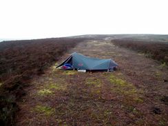
Last night I had one of the most uncomfortable nights camping that I have had for some time. When I went to sleep the weather had been quite promising and I had been hopeful for a nice sunrise, but as the night went on the winds strengthened and the rain came in. By the time that I awoke the wind had been blowing fairly continuously, and the mesh design of the inner tent allowed the wind to whip up under the flysheet and head straight on through. Whilst in my sleeping bag I was as snug as a bug in a rug, but when I was outside it the breeze made me cold very quickly. To make matters worse the interior of the tent is very cramped, and this meant that to get out of the sleeping bag I had to move half way out of the tent. It was therefore an uncomfortable night, and things did not improve in the morning.
This experience has convinced me of one thing; when I come to do the TGO challenge in May I shall take my North Face Westwind with me; although this is heavier it is far comfortable to sleep in. It allows me to move around and get dressed comfortably, and does not allow the wind in. I waited for a gap in the rain, crawled out of the tent, pulling my rucksack out after me as I did so. Naturally as soon as I was out and rolling my sleeping bag up it started to rain again; with my balaclava and coat on my trunk was warm enough, but my fingers soon became numb as I struggled to dismantle the tent.
Fortunately the rain did not last long, and I was soon throwing my rucksack on and heading down the obvious track that lead inexorably down to Ilkley. The path is very well used and in places had been reinforced with wooden planking causey, allowing me to make good time, even if some of the boards creaked ominously with the combined weight of me and my pack. I soon found myself descending down the steep and stony path towards the prominent White Wells, and on along path to reach the road that led me on down towards the centre of Ilkley.
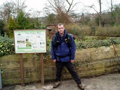
Familiarity made it easy for me to find the railway station, and I then walked on through the town. I soon passed a shop, where I stopped to buy a couple of chocolate bars and a hankie to try and stem my rapidly dribbling nose. According to the guide that I had with me the start of the Dales Way is at a road bridge immediately to the south of the station; I made my way there and walked along the southern bank of the river towards some public toilets. Just before I reached them four people came out of a hotel; it was obvious that they were walkers and I chatted to them for a few minutes before nipping in to the toilets. After I emerged I walked on to a very attractive arched bridge where there was a Dales Way sign. The two couples were there and it seemed as though this elegant bridge was a much better start point. I took a couple of photos of them and they took one for me, before we walked off together. They were walking as far as Bunsall today and I soon left them behind me as I strode along good footpaths beside the river.
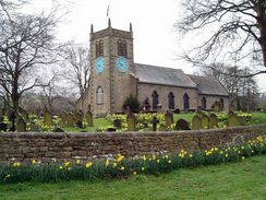
Attractive riverside paths followed, leading me on past some mills and some typical mill streets towards Addingham Church and the village itself. The path did not enter the village, but skirted it, following good paths northwards along the western bank of the river. Near the obscurely-named Paradise Lathe the footpath crossed the busy B6160 road and passed a seventeenth-century Quaker meeting house. The footpath skirted the road as it headed northwestwards, which must have been a better alternative that walking along the road, which the Dales Way used to do until the diversionary footpath was made in 1996.
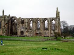
I missed the turn off from the footpath and headed uphill for a hundred yards before turning back and joining the road to walk towards the A59 bridge. A footpath led under this and under the adjacent old stone bridge, and once on the other side I got my first sight of Bolton Abbey in the distance. From a distance it seemed impressive, and as I walked along the floodplain toward it the ruins grew in grandeur. It is quite an unusual set of ruins as the old 12th Century Augustinian Priory Nave was converted into a parish church at the time of the Dissolution. This means that the ruins seem to grow as an extension of the church, something that I cannot recall having seen before.
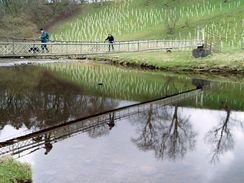
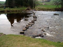
Right by the ruins some stepping stones and a grand bridge lead over the river, which runs past a high cliff downstream. I decided that crossing the stepping stones with my pack on would easily, so I used the bridge to cross to the other side and followed the path, which rose and fell as it headed northwards. It eventually rejoined the valley floor just in time to reach a bridge over the river, which I crossed to reach The Pavilion. This is a large wooden refreshment hut (although hut really does not do it justice), and I dumped off my rucksack and went inside to buy some Ribena. The place was understandably busy, and I enjoyed the drink as I watched people flow past. I could not stop too long, however, and so I threw my rucksack back on and headed off down the path.
Here the River Wharfe passes through an area called The Strid, where the river narrows through and eventually passes through a cataract called The Strid. On the way there I passed a couple of backpackers, laden down with rucksacks and tents. As I passed hem we started to chat, and I am amazed to find out that they were from Cambridge and worked in computers. We chatted as we passed the Strid, and I robustly decided not to jump across th4 six-foot gap (many people have died attempting this). At the impressive castellated footbridge over the river near Barden tower I kept on the western bank whilst the couple swapped over to the eastern bank; after I had walked a few hundred yards I realised that they had taken the proper Dales Way; it was no bother, as the next bridge was less than a kilometre away, and I rejoined the Way there.
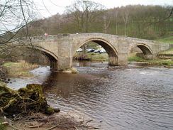
The next few miles were attractive but fairly pedestrian, and I walked on autopilot whilst I let the scenery wash over me. My left shoulder was starting to ache again, and when the path reached a bridge and the Red Lion Hotel in Burnsall I decided to stop off. I dumped my rucksack onto the patio at the rear of the pub, took my boots off and walked in to buy a pint. I also wanted to buy some crisps but unfortunately they did not sell them, preferring to make money from meals. This was a shame, but I enjoyed sitting outside, supping the pint slowly. I also decided that I would not camp out tonight; not only did I wanted a certain amount of comfort after the rough night last night, but the campsites were over a mile out of Grassington. As I drank I therefore phoned up Grassington Tourist Information and got accommodation sorted at a B&B just outside of Grassington
I told the landlady that I would be in at four thirty, and so I swigged down the rest of my pint and headed off down the road. The next four miles to Grassington were very pleasant and I enjoyed the walk, not the least because the little break had helped my left shoulder to recover. I soon passed Litton Falls, where there is an impressive little stretch of rapids, and I joined a route that I had walked last May. Another stretch of riverside walking took me to a road, and I followed this up into the village of Grassington. I found my way to the Tourist Information�office only to find it closing at four - an early time on a bank holiday, especially as it was scheduled to open to five in April, only a few days away. Fortunately a lady was just closing the door, and I discovered that the bunk barn at Cam houses was now a B&B; I shall have to phone up tomorrow to get the number.
Slightly annoyed at the early closing time, I went into the centre of the superb village to get some shopping before heading off back down the road to the B&B. They made me feel very welcome, and I was soon soaking myself in the shower, where I discovered some chaffing that I had not detected on the walk.
Directions
As I camped last night nearby, I will start the directions for this walk from the Twelve Apostles Stone Circle. Leave the circle and follow the obvious path that heads north. After a few hundred yards this meets a footpath marker stone at Gill Head, where the path begins to drop, crossing a very boggy area on a wood causey. At the end of the causey the path descends down past Ilkley Crags, along some steep and much eroded steps made of stone slabs. It is the only troublesome section of the entire walk across Ilkley Moor, and once at the bottom the gradient slackens for the descent down to the obvious whitewashed building at White Wells.
Pass the building and continue on downhill, and when a road is reached continue straight on down it towards the centre of Ilkley. When this road ends at a main road with the railway station to the right, turn left and then almost immediately right, to walk north along another road through the centre of the town until a bridge over the River Wharfe is reached. Do not cross the bridge, but instead turn left and descend down to a path that runs westwards along the southern bank of the River Wharfe; the Dales Way starts at the next bridge, which is reached after a couple of hundred yards.
The rest of this walk follows the Dales Way; as this is a named trail I will not give directions. Instead I will refer you to the Ordnance Survey Recreational Path Guide for the path, which I used throughout my walk, and it proved to be invaluable. This book also includes details of the Leeds extension to Ilkley, which adds twenty miles onto the Dales Way.
Distances
| From | To | Distance (m) | Ascent (ft) | Descent (ft) |
|---|---|---|---|---|
| Ilkley Moor | Ilkley station | 1.9 | 20 | 945 |
| Ilkley station | Bolton Abbey | 6.3 | 371 | 371 |
| Bolton Abbey | Burnsall | 7.1 | 994 | 994 |
| Burnsall | Grassington | 3.6 | 528 | 358 |
This makes a total distance of 18.9 miles, with 1913 feet of ascent and 2668 feet of descent.
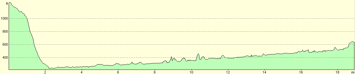
For more information on profiles, ascents and descents, see this page
Accommodation
I spent he night at Craiglands B&B, 1 Brooklyn, Threshfield, Grassington, BD23 5ER, telephone (01756) 752093. This was a very nice B&B, and they made me feel very welcome. A single room cost me thirty pounds for the night, and the centre of Grassington was a nice ten minute amble away.
Disclaimer
Please note that I take no responsibility for anything that may happen when following these directions. If you intend to follow this route, then please use the relevant maps and check the route out before you go out. As always when walking, use common sense and you should be fine.
If you find any information on any of these routes that is inaccurate, or you wish to add anything, then please email me.
All images on this site are © of the author. Any reproduction, retransmissions, or republication of all or part of any document found on this site is expressly prohibited, unless the author has explicitly granted its prior written consent to so reproduce, retransmit, or republish the material. All other rights reserved.
Although this site includes links providing convenient direct access to other Internet sites, I do not endorse, approve, certify or make warranties or representations as to the accuracy of the information on these sites.
And finally, enjoy your walking!
This walk was mentioned in the following routes:
| The Dales Way |
Nearby walks
| # | Title | Walk length (miles) |
|---|---|---|
| 35 | East Marton to Malham | 9.2 |
| 97 | Shipley and Baildon Moor circular. | 7.7 |
| 98 | Shipley to Ilkley | 9.5 |
|
|

|