Walk #658: Grassington to Swarthgill
 |
 |
|
General Data
| Date Walked | 26/03/2005 |
| County | North Yorkshire |
| Start Location | Grassington |
| End Location | Swarthgill |
| Start time | 08.57 |
| End time | 16.57 |
| Distance | 18.0 miles |
| Description | This was a good day's walk; the first third was over classic limestone pavement scenery, whilst the rest of the day was following the River Wharfe towards the watershed. |
| Pack | Today I carried my 70-litre Craghoppers WildPlaces 70-liotre rucksack, filled with full camping gear and food. |
| Condition | Aside from slight trouble with chaffing I feel fine - I still have no blisters and my left shoulder feels much better. This is quite good after three days of fairly strenuous backpacking. |
| Weather | The sun was warm through the window this morning and this made me hope that a sunny day was ahead. However once I set off drizzle soon started to fall, and rainbows abounded as I walked towards Kettlewell. Once I had started walking the only time that I saw the sun was from intermittent, short breaks through the cloud. The cool wind made it quite chilly when I was exposed to it, although when I was sheltered it was quite a comfortable temperature for walking. |
| OS map | Landranger number 98 (Wensleydale & Upper Wharfedale) |
 |
 |
|
 |
 |
|
Map of the walk
Maps courtesy of Google Maps. Route for indicative purposes only, and may have been plotted after the walk. Please let me have comments on what you think of this new format. For a detailed table of timings for this walk, please see the table file.
 |
 |
|
Notes
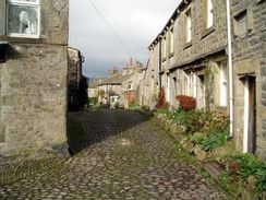
As I awoke this morning the sun was streaming through a gap in the curtains, and I quickly drew them to reveal bright sunshine outside. By the time that I had been downstairs for a lovely breakfast the room had warmed up, and I therefore decided to set off in shorts and a short-sleeved base layer. I was glad that I had had a good night's sleep, as the previous night when I had camped on Ilkley Moor had been rough and I had not got as much useful sleep as I would have liked. I pulled all my kit together and said goodbye to the proprietors of the B&B before reluctantly leaving. I took it easy over the initial climb from the bridge over the Wharfe into the centre of Grassington as I had not done any stretching exercises. On the way I passed a fountain of water emerging from a broken manhole in the road, the water glinting majestically in the sunshine. By the time that I had walked to the Tourist Information office in the village (where I had ended yesterday's walk) clouds had gathered, and as I walked up through the beautiful high street I started to feel distinctly chilly. I did not bother going into any shops as I had plenty of provisions, and instead headed on out of the village.
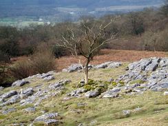
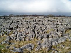
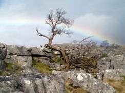
Almost as soon as I had emerged onto the path to Kettlewell it started to drizzle lightly. As I was unsure how long this would last I walked on, passing some wonderful patches of limestone pavement as the sun made occasional appearances. The combination of drizzle and sun caused several rainbows, which offset the greys of the limestone magnificently. Consequently despite the drizzle I really enjoyed this stretch of the walk; limestone pavement has long been a favourite type of landscape, and this stretch to the north of Grassington is superb. Eventually I started to feel quite chilled, so I shrugged my rucksack off onto a rock and put my coat and waterproof trousers on, the latter going directly over my shorts. I instantly felt warmer, and continued on along the path towards Conistone.
I had walked this short section of the Dales Way eleven months previously as part of a four day wild camp in the Dales, and I soon reached Bycliffe Road, where I had departed from the route. This time I continued on along the Dales Way, as it skirted beneath a low limestone escarpment to my right; in the sun it would have been a superb walk, but the increasingly heavy drizzle put a slight damper on the situation. I was quite surprised to note that I had not seen anyone on the path from Grassington; I would have expected the path to be very busy, as it had been last year when I had walked along it. Obviously the weather and early hour was putting people off.
The last mile or so into Kettlewell involved crossing many little field boundaries with various different types of stile, and these slowed me up and tired me considerably. Crossing stiles is always annoying, and it becomes doubly so with a heavy pack on. I took my time at each stile, having to then cross a field which would invariably be less than fifty yards across to another stile, and then repeat the process. I was therefore quite relieved when Kettlewell came into view and I could actually walk for a distance without having to cross any stiles. The village was relatively quiet, and I nipped into a walking shop to buy some plastic tent pegs. When I had been camping on Ilkley Moor the other night I had noticed that I had no spare pegs, and so the shop seemed to be a good place to get an emergency stash. After I left I stopped on a bench in the middle of the village in order to change the battery on my Walkman and to stow the pegs, before heading off to the New Bridge over the Wharfe. Instantly I reached a problem; the small clapper gate by the bridge was not wide enough to get my pack through, and I had to half-climb over it to get through. This was annoying, and although the drizzle had lessened I found myself to be in a fairly grumpy mood.
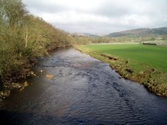
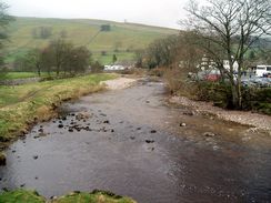
Even the views of the Wharfe could not improve my mood much, as I was well aware that if the sun was shining they would be much better. I found the walk itself to be fairly boring as the Dales Way followed the western bank of the river northwestwards, and the only event the enlivened the monotony was meeting a gent whom I chatted to for a few minutes. He was camping on the fells for a few days, and I found that it was nice to have someone to talk to, even if it was only for a few minutes. Eventually the path crossed the road leading to Buckden, and this marked my approach to the hamlet of Hubberholme. I soon found myself at the George Inn, and I went in to get out of the drizzle.
The people in the Inn seemed very friendly, and so I decided to have a pint of Black Sheep, which went down nicely. Whilst I drank some food was brought out for some other customers, and the irresistible aroma meant that I was soon ordering a large seafood medley to eat. I washed this down with another pint, and also used the opportunity to try and find somewhere to camp for the night. There was no reply from Cam Houses, but the gentleman who ran the accommodation at Swarthgill, about two miles before Cam Houses, told me that whilst the house was full for the night, I was welcome to camp outside. This cheered me up a little, as it meant that I would not have the usual last minute worries about finding somewhere to pitch my tent.
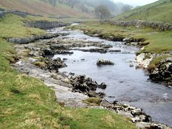
The meal and the drink meant that I spent well over an hour in the Inn, and by the time that I emerged out the drizzle had stopped, although the clouds overhead threatened rain at any time. I really wanted to take a look around Hubberholme Church, which apparently has an elaborate rood loft and screen, but I wanted to press on in case it started to rain once again. The ground underfoot was muddy but the path was easy to follow as I headed westwards along the Wharfe, which was becoming less river-like the nearer I got to the watershed. I powered though Yockenthwaite, and totally missed the nearby small stone circle that I had wanted to explore. When I reached Deepdale Bridge a little further on I chose not to follow the Dales Way on the southern bank but to walk along the road instead; there were several reasons for this, the mud and the need to get to the place that I was planning to camp early. With hindsight this was a shame, and although it did not shorten the walk much the path on the other side, which was in clear view at all times, seemed to be a much better walk.
At a road junction I rejoined the Dales Way and continued on northwards towards the village of Oughtershaw. At one point I passed a cleft in the rock with a drinking trough underneath; water poured from the cleft and into the trough, which I could not help but think was a very effective use of a natural water source. The grey clouds overhead meant that it was getting quite dim as I reached the small collection of houses and farms that make Oughtershaw, and I started walking along the long track, firstly to Nethergill, and then on to Swarthgill and the place that I was planning to camp. At this point the Wharfe was little more than a stream that ran across boggy land beside the track, a sign that I was now high up in the watershed. As I walked a Landrover pulled up beside me, and the man inside asked me if I was the man who had phone up to ask if I could camp. I responded that I was, and he told me that I could camp in a field with a caravan in it. I then said that I was feeling fit and considering walking on to Cam Houses, but he expressed a fear that I may not be allowed to camp there, thus kyboshing that idea.
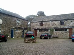
I soon reached Swarthgill, which turned out to be quite an imposing collection of buildings set in the bleak moorland landscape. I spent a few minutes trying to find the best spot to camp; the ground was quite boggy (there was a stream running nearby), and eventually I chose a spot between the caravan and a gate. It did not take me long to get my tent up, and once I had done so I went up to the house to tell the people staying there that I was in the field. I got the impression that a party was in full swing, and after I had chatted to a nice lady for a few minutes I went back to my tent and waited for it to get dark. As I lay in my tent I reflected on a good day's walking, which had not quite been spoilt by the grey and dismal weather. For one thing, I will long remember the magnificent double rainbow that I had seen earlier in the day over the limestone pavement to the north of Grassington. Of such moments life is truly made.
Directions
This walk follows the Dales Way; as this is a named trail I will not give directions. Instead I will refer you to the Ordnance Survey Recreational Path Guide for the path, which I used throughout my walk. This proved to be invaluable, and is bound to be kept more up to date than any directions I put on this site. The book also includes details of the Leeds extension to Ilkley, which adds twenty miles onto the Dales Way. Please click on the image below to go to the Amazon page for this book.
Distances
| From | To | Distance (m) | Ascent (ft) | Descent (ft) |
|---|---|---|---|---|
| Grassington | Kettlewell | 6.0 | 827 | 705 |
| Kettlewell | Hubberholme | 6.0 | 387 | 354 |
| Hubberholme | Swarthgill | 6.0 | 978 | 499 |
This makes a total distance of 18.0 miles, with 2192 feet of ascent and 1558 feet of descent.
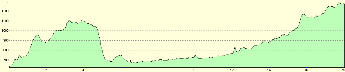
For more information on profiles, ascents and descents, see this page
Accommodation
I spent the night camping in a field by the farm at Swarthgill. There is some accommodation available here sometimes, and if you want to camp I would suggest that you phone them on (01756) 760466 for permission.
Disclaimer
Please note that I take no responsibility for anything that may happen when following these directions. If you intend to follow this route, then please use the relevant maps and check the route out before you go out. As always when walking, use common sense and you should be fine.
If you find any information on any of these routes that is inaccurate, or you wish to add anything, then please email me.
All images on this site are © of the author. Any reproduction, retransmissions, or republication of all or part of any document found on this site is expressly prohibited, unless the author has explicitly granted its prior written consent to so reproduce, retransmit, or republish the material. All other rights reserved.
Although this site includes links providing convenient direct access to other Internet sites, I do not endorse, approve, certify or make warranties or representations as to the accuracy of the information on these sites.
And finally, enjoy your walking!
This walk was mentioned in the following routes:
| The Dales Way |
Nearby walks
| # | Title | Walk length (miles) |
|---|---|---|
| 35 | East Marton to Malham | 9.2 |
| 36 | Malham to Horton in Ribbesdale | 14.7 |
| 37 | Horton in Ribbesdale to Hawes | 14.0 |
|
|

|