Walk #659: Swarthgill to Sedbergh
 |
 |
|
General Data
| Date Walked | 27/03/2005 |
| County | North Yorkshire, Cumbria |
| Start Location | Swarthgill |
| End Location | Sedbergh |
| Start time | 08.14 |
| End time | 17.43 |
| Distance | 20.0 miles |
| Description | This walk takes you over the highest point on the Dales Way, and the short climb is followed by a long descent along the Dee Valley, with occasional climbs up the valley sides. |
| Pack | Today I carried my 70-litre Craghoppers WildPlaces 70-liotre rucksack, filled with full camping gear and food. |
| Condition | Aside from feeling slightly fatigued I am fine after this walk. I still have no blisters and my shoulders gave me little trouble. Despite the length of the walk I still have plenty of spare energy and could easily have walked further after a short rest. |
| Weather | Today was a damp, dreary day with occasional bursts of rain. The sun did not make an appearance at all, and it was quite chilly when exposed to the wind. |
| OS map | Landranger number 98 (Wensleydale & Upper Wharfedale) |
 |
 |
|
 |
 |
|
Map of the walk
Maps courtesy of Google Maps. Route for indicative purposes only, and may have been plotted after the walk. Please let me have comments on what you think of this new format. For a detailed table of timings for this walk, please see the table file.
 |
 |
|
Notes
I had a reasonable night's sleep, probably mainly because my campsite was sheltered from the wind to a certain extent by the caravan on one side and a wall on the other. I woke up knowing that it had been wet overnight, and when I unzipped the entry flap I was indeed greeted with an overcast and grey sky. There seemed little point in waiting around, so I struggled to get dressed in the limited confines of the tent and then got up. I prevaricated as I took my tent down, my hands becoming wet from the wet flysheet and my fingers numb from the cold as I did so. Eventually my rucksack was filled, and I lifted it onto my shoulders, reluctantly said goodbye to Swarthgill and headed westwards across the moorland.
Initially the path was relatively easy to follow, although I was surprised as it descended into a series of small, steep-sided gullies. These proved tiring on legs that had not yet fully warmed up, and I was slightly relieved when I reached a flatter (although boggy) area of ground near a line of four dilapidated, abandoned barns. I passed the first two of these and then went wrong; the path turned to the right to angle up towards Cam Houses, but I continued on towards the final Brow's Barn. Here my progress was stopped by Tur Gill, which fell down a large waterfall into the valley. I realised that I had made a mistake, but instead of turning back I resolved to climb up the steep hillside neat the Gill.
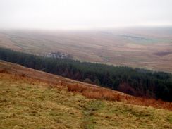
Eventually I reached the path once more just before Cam Houses, and I walked through the farmyard, which was a bigger complex of buildings than I had been expecting. Smoke was rising from the chimney and a lady was washing the dishes at the kitchen sink; the farm is so remote I had to wonder how lonely she must get living literally in the middle of nowhere. Once past the farm the path became very boggy as it headed westwards, skirting the edge of some coniferous woodland before rising up the hillside to reach the fingerpost that marks Cam High Road, an unsurfaced track.
The clouds had lifted slightly by the time that I reached the old Roman Road, which was a special point of the walk for several reasons; firstly, it was the highest point on the Dales Way, at about 516 metres. Secondly, Cam High Road also carries the Pennine Way as it heads north from Horton-in-Ribblesdale to Hawes, and thus it meant that I had finally linked up the walks that I have done in the Ilkley area over the years with the rest of my walks. I turned left and started walking southwestwards along the road, which unfortunately is a by-way and has suffered massively from overuse by four wheel drives and motorbikes. The road was heavily rutted, and as I headed downhill I was passed by three motorbikes with studded tyres, the studs digging up yet more of the surface. In places the exposed peat was very wet and boggy, and in these places the road had widened considerably as people had diverted around the boggy areas. This meant that what must have been a special route had been spoilt to a large degree, and I was quite relieved when I reached Cam End, where the Dales Way diverted westwards from the road.
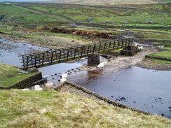
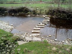
The path down towards the road at Gearstones was less eroded but just as boggy, and I took this stretch relatively slowly to prevent myself from slipping over. Just before I reached the ford and footbridge over the Gayle Beck I met a group of walkers coming uphill; we chatted for a while and I continued on to the road. I had lost nearly 200 metres in altitude from Cam High Road, and as I joined the road for a short period I finally started to feel a little warmer in the shelter. I soon warmed up even more as the path climbed up past the farm at Winshaw and then started heading northwards. Again the ground underfoot was saturated, and there were several deep gullies that had to be negotiated before I finally reached a track called Black Rake Road immediately to the north of High Gayle. I had been expecting this to allow easier going, but unfortunately this was not the case as the ground underfoot was wet and there were large boggy patches that had to be negotiated.
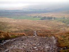
For this reason reaching the surfaced road was a relief, and I walked down it towards Dent Head Viaduct with some joy. The road descended steeply, and as I followed it I passed some cyclists making their way uphill. I gave them some words of encouragement, but for most of the time my eyes were focussed on the magnificent viaduct, which dominated the view. The viaduct carries the Settle and Carlisle railway line over a deep valley, and it is a superb example of a stone viaduct, having a slight curve to it as it soars overhead. Eventually the road passed under it, and as I passed under I could not help but look up at the viaduct's grandeur, which fits into the bleak landscape to great affect.
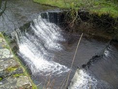
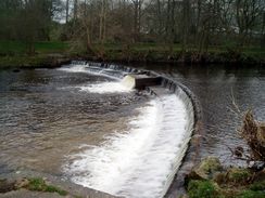
Once it had passed the viaduct the road levelled out, descending slowly alongside the fledgling River Dee. I found the river, which initially was little more than a stream, to be quite fascinating, as it flowed over a series of small ledges, the rock in the vicinity being horizontal. There were not many signs of life at the youth hostel, and I continued on past Scow Force (a small waterfall) towards Cow Dub Bridge. Here I met a man who was resting on the bridge abutment, he had a small pack than me but it looked obvious that he was also camping out. As we chatted it turns out that he too was walking the Dales Way, and that he had set off from Ilkley on Thursday. I was keen to press on, and as I walked down the road I looked back to see him just starting off, worryingly limping slightly as he did so.
A few hundred yards later I was surprised to find an Inn, and, not believing my good fortune, I nipped in, and quickly ordered a pint of Black Sheep and a pint of water. I skulled the water down, and sat down at a table to slowly sup the pint. I had not had any breakfast, and the rumbling of my stomach caused me to order a meal - sausages and mash, which was superb, and it was washed down with another half of Black Sheep. As I ate I chatted to a few locals, and it was obvious that the pub was the centre of the local community, with everyone on first name terms. With reluctance I left the Inn, and started walking down the road the short distance to the Lea Yeat Bridge. Here the Dales Way finally leaves the road, and follows the western side of the Dee westwards. It rejoins the road for a short period at Ewegales Bridge, before heading uphill into a patch of woodland.
In the woodland I met the gentleman once again, and I was surprised that I had caught up with him so quickly, despite my long stop at the Inn. We had another quick chat, and it turned out that he occasionally stopped to do sketches; a very rare thing for long-distance walkers, who mostly seem to take photographs and move on. I headed off, soon emerging from the woodland and continuing on as the path skirted the base of the hillside to the south of the River Dee. By this stage the river was becoming more beautiful as it was widening, and I was glad when the footpath joined the river bank for a short distance to the Tommy Foot footbridge, where it once again left the river, making a big diversion southwestwards uphill and then heading back to the river.
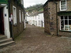
Dent became visible in the distance well before I reached Church Bridge. The path dies not officially enter the village, but I chose to make a little diversion uphill to visit it, and I was glad that I did. The church is a gem, and I used the opportunity to nip into a shop to buy some more batteries for my GPS and a pack of four Eccles Cakes. There is a phone box in the village and I walked along the beautiful cobbled streets past a prominent granite memorial to Adam Sedgwick, who was a pioneer of geology. Unfortunately I could not find anywhere to sleep for the night from the numbers that I had taken with me, so I headed off back to the church where I sat down and scoffed the Eccles Cakes. Dent also used to be home to the 'Terrible knitters of Dent', so called because of the fast speed that they knitted. I am unsure why such a village had produced fast knitters - did they have a different knitting style to other villagers?
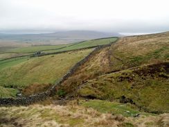
Eventually I tore myself away from the village and headed back down to Church Bridge to rejoin the Dales Way. A really nice stretch of path followed the Dee westwards to Barth Bridge, and I enjoyed my stroll along this section. It continued along the southern bank of the river as it started to drizzle, eventually reaching a footbridge where it left the river for the last time today. I was getting quite tired by this time and I was slowing down as I climbed uphill towards the farm at Leaksies. On the way to this farm I passed a boggy area, and as my boots sunk in I realised with horror that the boggy area had been caused by run-off from a slurry heap a little further uphill. I pulled my foot out to find it coated in a brown, stinking slime, and my other boot got similarly covered at my next step.
Cursing slightly, I walked on through the farmyard in the drizzle, my mood matching the weather quite well. I still had not booked any accommodation for the night and I really did not fancy wild camping, so I spent ten minutes phoning up various places before I eventually managed to get the number of the campsite in Sedbergh. This was not ideal as it was about a kilometre off the route, but the thought of a warm shower was irresistible. Having booked accommodation took a little weight off my mind, and I had more of a spring in my step as I followed the Dales Way northwestwards. On the last climb before the descent into Milthrop I passed a young couple who were walking the Way; we chatted for a few minutes. They were camping in Dent for the night, and I quickly grew a liking to them. My mood improved yet again, and I descended down to the little village of Millthrop. This was an attractive village, but I probably did not get the next feel for it in the drizzle and gloom - in the sunshine it would probably be beautiful. A few yards out of the village I reached the bridge over the River Rawthey, where I left the Dales Way for a nice, if muddy, stroll eastwards to the Pinfold campsite.
It did not take me long to out my tent up, and I son found myself walking the short distance to a seemingly brand-new amenity block. I felt very guilty going in in my muddy trousers and boots, especially as much of that mud was from the slurry at Leaksies. The shower was steaming hot, and as I stood under it I could feel my fatigue washing away with the mud, a feeling that was more than a little welcome. The site cost me five pounds for the night, which was worth it for the shower alone, and I felt really happy as I went back to my tent and settled down to go to sleep. Some of the other campers were heading into Sedbergh for a drink, but with my boots covered in grime I really did not want to join them. I am feeling really confident; the walk has gone really well so far, I am not suffering from any problems and I feel as though I am match fit for the TGO Challenge walk in May.
Directions
The majority of this walk follows the Dales Way; as this is a named trail I will not give directions. Instead I will refer you to the Ordnance Survey Recreational Path Guide for the path, which I used throughout my walk. This proved to be invaluable, and is bound to be kept more up to date than any directions I put on this site. The book also includes details of the Leeds extension to Ilkley, which adds twenty miles onto the Dales Way. Please click on the image below to go to the Amazon page for this book.
The only diversion from the Dales Way is at the end of the walk to reach the Pinfold Caravan Site where I spent the night. When the bridge over the River Rawthey is reached in Millthrop, do not follow the Way across the bridge but turn right, to follow the southern bank of the river northeastwards to New Bridge in Sedbergh. The Pinfold caravan site is immediately on the other side of the bridge.
Distances
| From | To | Distance (m) | Ascent (ft) | Descent (ft) |
|---|---|---|---|---|
| Swarthgill | Gearstones | 4.6 | 597 | 827 |
| Gearstones | Dent Head | 3.0 | 489 | 433 |
| Dent Head | Dent | 6.5 | 404 | 1024 |
| Dent | Sedbergh | 5.9 | 509 | 627 |
This makes a total distance of 20.0 miles, with 1999 feet of ascent and 2911 feet of descent.
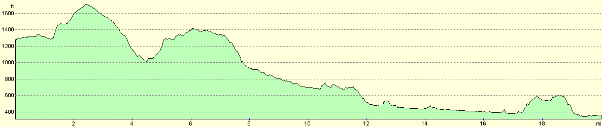
For more information on profiles, ascents and descents, see this page
Accommodation
I spent the night at the Pinfold caravan site, Garsdale Road, Sedbergh, Cumbria, LA10 5JL, telephone (01539) 620576. This site was convenient for the centre of Sedbergh, and cost me only five pounds for the night. The facilities were good and the showers nice and warm; a stay here was much preferable to wild camping.
Disclaimer
Please note that I take no responsibility for anything that may happen when following these directions. If you intend to follow this route, then please use the relevant maps and check the route out before you go out. As always when walking, use common sense and you should be fine.
If you find any information on any of these routes that is inaccurate, or you wish to add anything, then please email me.
All images on this site are © of the author. Any reproduction, retransmissions, or republication of all or part of any document found on this site is expressly prohibited, unless the author has explicitly granted its prior written consent to so reproduce, retransmit, or republish the material. All other rights reserved.
Although this site includes links providing convenient direct access to other Internet sites, I do not endorse, approve, certify or make warranties or representations as to the accuracy of the information on these sites.
And finally, enjoy your walking!
This walk was mentioned in the following routes:
| The Dales Way |
Nearby walks
| # | Title | Walk length (miles) |
|---|---|---|
| 36 | Malham to Horton in Ribbesdale | 14.7 |
| 37 | Horton in Ribbesdale to Hawes | 14.0 |
| 38 | Hawes to Keld | 12.9 |
|
|

|