Walk #431: Robin Whins Point to Askam in Furness
 |
 |
|
General Data
| Date Walked | 02/05/2003 |
| County | Cumbria |
| Start Location | Robin Whins Point |
| End Location | Askam in Furness |
| Start time | 09.20 |
| End time | 16.31 |
| Distance | 17.9 miles |
| Description | This was a surprisingly enjoyable walk, and one that would have been far better in good weather. |
| Pack | Today I carried my 30-litre Karrimor HotRock rucksack, which was filled with my packed lunch, waterproof leggings, water bottle and a couple of spare shirts, together with the usual assortment of odds and ends. |
| Condition | I feel absolutely fine after this walk, and I could easily have walked further if the weather had been better. Both of my ankles were fine, and I had no real problems with my right thigh, which had been aching during yesterdays walk. |
| Weather | Today was quite a wet day, and it rained at various strengths all day. There was not much wind to accompany it, and it was quite a warm day. The rain was not very hard for most of the day despite being continuous, and it could certainly have been far worse. |
| OS map | Landranger number 96 (Barrow-in-Furness & South Lakeland) |
 |
 |
|
 |
 |
|
Map of the walk
Maps courtesy of Google Maps. Route for indicative purposes only, and may have been plotted after the walk. Please let me have comments on what you think of this new format. For a detailed table of timings for this walk, please see the table file.
 |
 |
|
Notes
Looking on the map a few days ago I expected Barrow-in-Furness and Walney Island to be drab and depressing, but even in the rain this was not the case. If I had more local knowledge and the weather had been better it would have been interesting to walk around the southern and northern parts of the island, instead of doing the truncated version that I did today. This is one of the most frustrating parts of this walk so far - on the map I could see some potentially interesting areas, but there have been no public rights of way to them This situation will be different in Scotland, as there are no rights of way, and technically I can devise my own routes.
It was a shame that the weather was so wet, as it would have been nice if I could have done this walk in good weather. It always amazes me how some areas can be nice even in the rain, when there is little reason to expect them to be so - to my mind this is a classic example. There was no reason for this walk to be nice from looking at the map, but once on the walk it was hard to find anything to dislike. Perhaps I was just in a good mood, and this coloured my views of the area.
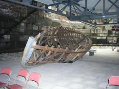
When I was in Barrow-in-Furness I had to pass the Boat Museum. This was housed in a building that looked quite intriguing from the outside - a half conical structure. As I walked past the museum I saw some free admission signs, and as the rain was falling hard at this time I decided to nip in. This was a great decision, as the museum is absolutely fascinating. The building itself is built over an old graving dock (a type of dry dock), and there are three floors suspended in the dock, the stepped stonewalls being fully visible. The museum details the history of the Furness Railway, the local ironstone industry and the shipyards. Of these I found the information about the shipyard to be most fascinating, and in particular the models of some of the ships that they have built. These models are incredibly well detailed, even to the extent of having opening doors and wallpaper inside the cabins. They were generally built to a scale of 1 to 48, and I could have spent all day studying them if I had the time. I only pent a little over half an hour in the museum, but I could easily have spent longer. Even the dock itself is of interest - the marks on the wall indicating the depth of the water in the dock, and the stone designed to break up the flow of water when it was being filled.
For half an hour north of the museum I walked with a local lady, who was out walking her dogs. We chatted as we walked along, and I was continuously kicking an old coke bottle that her dog was found. He would dutifully bring it back, and then I would kick it away once again for him to fetch it back to me. This was quite an enjoyable game, and I liked having someone to chat with as I walked. Sometimes I feel like I must be doing the most antisocial coastal walk ever, as I rarely get too chat to people and do not have anyone walking with me - both Tom and Graham have had people walking with them. Doing 8it my way does have advantages, however; I can alter my pace to how I am feeling without considering anyone else, and I can be left to my own thoughts, to sort out all the problems in the world in my mind.
By the time that I reached Sam in Askam in Furness I was starting to get fed up with the rain, and as I had done nearly eighteen miles I decided to call it a day. We got a lovely view of the sun setting over the Duddon Sands - now devoid of water - and we went to the local pub for a quick drink so that we could use their facilities.
Directions
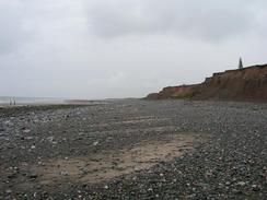
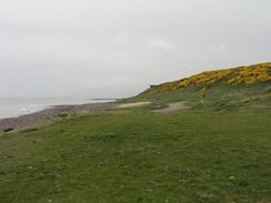
This walk starts off at a little lay-by by the entrance to a tip near Robin Whins Point on Walney Island. Turn right to head southeastwards along the road, passing Snab Point and South End Bungalow before reaching the entrance to a caravan park at Scar End Point. Instead of continuing on into the caravan park turn right and head down a track to the ruined buildings at Far South End. When the track ends at the farm climb over a fence and continue on to the low cliff edge, and then drop down onto the beach. Once on the beach turn right and follow it northwestwards for a couple of miles until a car park at Benty Haw is reached. Here you can climb up onto the top of the low cliffs and follow a surfaced path north a little distance away from the Biggar Bank Road. Continue on along this path until the surfacing ends near a golf course, and continue on along the path until it ends at a road at Earnse Point.
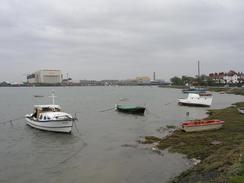
Turn right and walk eastwards along the road. Almost immediately this turns to the right to head southwards, and reaches a junction with Cows Tarn Lane to the left. Turn left and follow the lane as it curves around, heading in a rough easterly direction until it ends at another road in North Scale. Turn right down this road and follow it south beside the Walney Channel until the Jubilee Bridge is reached. Cross the bridge and enter Barrow-in-Furness. At a roundabout turn left down the A590 road until the Docks Museum is reached; here turn left and walk to the riverbank, where a path runs along the promenade. This path is called the Red Man's Way, a tribute to the ironworks that used to be where the path now runs. This path was opened in 1998, and I have never heard of it before. When the path ends near a large slagheap turn right and go under a low railway bridge (actually called Cocken Tunnel, after the ancient village that was once there) to the A590 road near Ormsgill Farm.
Follow the A590 road northwards for about a kilometre until a footpath heads off to the left across a field before climbing over a railway bridge and turning to Sowerby Lodge. The path then turns to the left to head westwards for about fifty yards to the beach. Turn right and follow the beach northwards past Sarth Bight, where an obvious track is met. This track can be followed all the way to a little area of habitation at Lowsy Point, where it ends. Join the beach and follow it as it curves around Sandscale Haws, eventually taking a more northerly course towards Askam in Furness. Pass through a little archway under Askam Pier and pass the lifeboat station; this walk ends at a car park a little under a kilometre further north.
For more details of the Cumbria Coastal Way, see the excellent little book, The Cumbria Coastal Way: A Walker's Guide", by Ian and Krysia Brodie, ISBN 187355110X. This book is a lovely and detailed description of the walk, and unfortunately I did not manage to get a copy until after I fnished the walk, for it would have been quite handy.
Distances
| From | To | Distance (m) | Ascent (ft) | Descent (ft) |
|---|---|---|---|---|
| Robin Whins Point | Bridge off Walney Island | 8.8 | 446 | 413 |
| Bridge off Walney Island | Askam in Furness | 9.1 | 302 | 312 |
This makes a total distance of 17.9 miles, with 748 feet of ascent and 725 feet of descent.
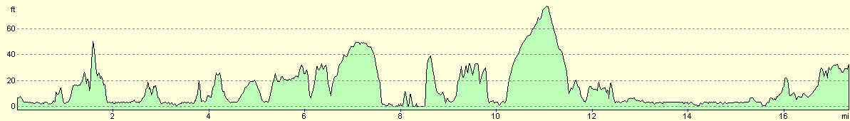
For more information on profiles, ascents and descents, see this page
Accommodation
We parked Mervan in the car park by the beach to the north of Askam in Furness, where I ended this walk. There were some fairly dingy toilets in the car park, and a pub a short distance up the road.
Disclaimer
Please note that I take no responsibility for anything that may happen when following these directions. If you intend to follow this route, then please use the relevant maps and check the route out before you go out. As always when walking, use common sense and you should be fine.
If you find any information on any of these routes that is inaccurate, or you wish to add anything, then please email me.
All images on this site are © of the author. Any reproduction, retransmissions, or republication of all or part of any document found on this site is expressly prohibited, unless the author has explicitly granted its prior written consent to so reproduce, retransmit, or republish the material. All other rights reserved.
Although this site includes links providing convenient direct access to other Internet sites, I do not endorse, approve, certify or make warranties or representations as to the accuracy of the information on these sites.
And finally, enjoy your walking!
This walk was mentioned in the following routes:
| My walk around the coastline of Britain |
Nearby walks
| # | Title | Walk length (miles) |
|---|---|---|
| 429 | Grange-over-Sands to Ulverston Sands | 22.8 |
| 430 | Ulverston Sands to Robin Whins Point | 18.0 |
| 432 | Askam in Furness to Haverigg | 19.6 |
|
|

|