Walk #429: Grange-over-Sands to Ulverston Sands
 |
 |
|
General Data
| Date Walked | 30/04/2003 |
| County | Cumbria |
| Start Location | Grange-over-Sands |
| End Location | Ulverston Sands |
| Start time | 08.57 |
| End time | 17.40 |
| Distance | 22.8 miles |
| Description | This was quite an enjoyable walk up and down the estuary of the River Leven, with some lovely views available northwards into the Lake District. |
| Pack | Today I carried my 30-litre Karrimor HotRock rucksack, which was filled with my packed lunch, waterproof leggings, water bottle and a couple of spare shirts, together with the usual assortment of odds and ends. For most of the walk I also had twelve 500-millilitre bottles of water in my rucksack, which added about six kilograms onto the pack weight. |
| Condition | The biggest problem that I have today is with my shoulders, both of which ache quite severely from the weight that I have been carrying in my pack today. These aches slowly subsided as the evening went on, and a long shower helped me recover as well. Aside from this I had no problems - my legs and feet are all fine. |
| Weather | Today was a dry day, which is quite surprising as heavy showers were forecast. Fortunately this did not happen, and as there was little wind it was quite a warm day. There were some long sunny periods, and these came in welcome. All in all this was an absolutely superb day for walking. |
| OS map | Landranger number 97 (Kendal & Morecambe, Windermere & Lancaster) |
 |
 |
|
 |
 |
|
Map of the walk
Maps courtesy of Google Maps. Route for indicative purposes only, and may have been plotted after the walk. Please let me have comments on what you think of this new format. For a detailed table of timings for this walk, please see the table file.
 |
 |
|
 |
Notes
Another day, another estuary. I am getting slightly fed up with all these estuaries that I am having to walk around - there are many of these in the northwest, and they are really stunting my progress. No sooner do I finish one - the Kent, I start another, the Leven.
I had been hoping to be able to walk around Humphrey Head, which as tracks (although not footpaths) marked around it. When I got there, however, I could not see any obvious track, and so I followed the Cumbria Coastal Way across the neck of the peninsular. At the road on the western side of the peninsular I met Sam, who had made me some sandwiches for lunch.
As I was walking along the road towards Flookburgh a nice car pulled over and the driver enquired about what I was doing. When I told him, he asked me to come to his factory around the corner and he would give me a donation. The factory was the Lakeland Willow water bottling plant, and the gent was the owner. I chatted to him for a few minutes and I looked into th3e plant, before he gave me a nice donation and twelve bottles of water to carry with me! This was exceedingly kind of him, and Sam and I drank some of the bottles this evening, and very nice they are to. They bottles only just fitted into my bag, and even after I had emptied the bag out it took me a few minutes to squeeze them in. The bottles added over six kilograms to the rucksack, which meant that it was by far the heaviest that it has been on the trip.
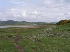
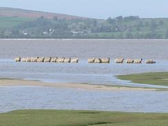
As I was walking up towards the farm at Sand Gate I came across an extreme example of stupid sheep. I had been watching this little flock of ten or so sheep on the Sand Gate Marshes. The tide was rising as I approached, and instead of going nearer to terra firma the sheep moved away until they were on a little island. The tide continued to rise and the sheep continued to retreat, until eventually there was no dry land left and the sheep were the island. I wondered about whether I should call a farmer out to do something about them, but I could not see who I should call or what they could do about it. Images of my getting roped in to drag wet, annoyed and resistant sheep onto a rocking rowboat crossed my mind, and so I thought better of it.
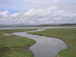
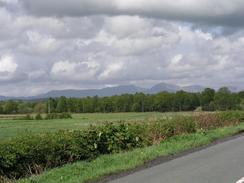
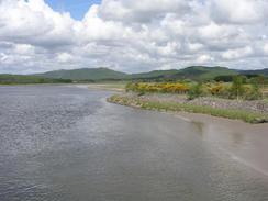
I stopped at the Rose and Crown Inn in Cark, where I nipped in so I could have a drink. I used this opportunity to write up the directions for a walk, which now means that my write-ups are nearly up to date. Normally when I walk into a pub I can easily chat to the people inside, but this pub was different - the landlord was monosyllabllic, a real laughing boy. This was a shame, as the pub was really nice and had a lovely interior that I had a quick look around before I left. From Cark the Cumbria Coast Way heads north over the hills, but I decided to walk along the B5278 road as it was technically nearer to the sea. Fortunately the road was not too busy, but I can imagine that the views from the proper path could be quite superb, with the lakes to the north and Morecambe Bay to the south. Eventually I reached the road bridge over the River Leven, and what followed was a nice walk westwards to reach a little footbridge over the River Leven at Greenodd. In the book John Merrill wrote about his walk in 1976 he describes crossing the river using an old railway bridge, but the new A590 road has removed all traces of this. The walk south down the A590 road was not very nice, and although the first stretch as far as a little picnic site had a little path beside the road, the rest of it did not, and I had to carefully walk alongside the road, picking my way through the traffic and getting bustled about by the wind from passing lorries - not a nice experience.
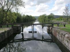
Canal Foot is a lovely little area. This is the place where the Ulverston Canal, built in 1796, meets the sea. It was built as the river up to the town had been strangled with silt, and at the time it was the shortest, widest, deepest and straightest canal in Britain. It has now fallen into disuse and a concrete dam blocks the seaward end at Canal Foot, with the old dock gates slowly rotting away beside it. Next to the canal there is a large factory, and I enjoyed peering past the buildings as I walked along the road past it. I was very tempted to end the walk here as I was exceedingly tired by this time, but I decided to force myself to do the next couple of miles southwards to where we had arranged to meet - something that I would not have done earlier in the walk, but I have far more confidence now.
The bathrooms at the campsite are absolutely marvellous. Instead of having communal areas they have a series of unisex cubicles, all of which have a shower, basin and toilet. I have seen these before at a few sites early on in the trip, and I had forgotten how nice they were. These cubicles even have heated floors, and the water was the perfect temperature. Before I got into the shower I had a shave, and when I looked into the mirror I did not recognise my body. This is a very strange thing to say, but it is even stranger to experience. My face, although more weatherworn, is definitely me, but my body is a thinner, leaner version. It just did not look like it was mine. I stood in front of the mirror for a few minutes, studying what I could of my body through my hair. I have exceedingly little fat on my body, my hips are protruding and my legs are very muscular. The shower helped my shoulders recover from the strains of today, although they still ached slightly by the time that I went to bed.
Directions
This walk starts off at a car park on the southern outskirts of Grange-over-Sands. Leave the car park and make your way down onto the promenade in the town - when I did this walk the bridge from the car park to the promenade was shut, so I had to walk the short distance down to Clare House Lane, which led across to the promenade. Turn right and walk southwestwards along the promenade until it ends, and then cross the railway line and continue on along a road on the other side of the line. When this ends continue straight on down a footpath that brings you out on a road in Kents Bank. Go straight on down the road towards the station in the village, and then follow the road as it turns to the right and heads uphill to the northwest. When the road ends at a junction with the B5277 road turn left down Jack Hill, and at the bottom before the B5277 is reached turn left and follow a footpath southwards across fields. The footpath passes under the railway line on a low bridge and passes a farm, before turning to the right to head over the throat of Humphrey Head and reaching a road near Wyke Farm.
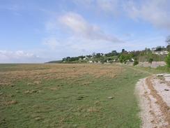
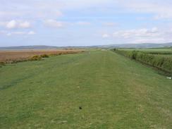
Once the road is met turn right and follow it northwards for about a hundred yards until it ends at a junction; at this junction turn left and follow this road westwards for a little over a mile until it ends at a T-junction to the south of Flookborough. Turn to the left and head south for a kilometre until West Plain Farm is reached, where you can turn to the right to walk westwards along a flood bank for two kilometres towards Cowpren Point. At Cowpren Point leave the flood bank and turn to the right to head northeastwards along the foreshore towards the farm at Canon Winder, which it skirts before heading north along the edge of a low bank beside the marshes until it reaches the end of a road at Sand Gate. At the end of the road turn right and follow it uphill for a short distance before a track leads off to the left. Follow this track as it heads northeastwards, crossing over a railway line and ending at a road in the village of Cark. Turn right down this road for a few yards before it ends at a T-junction with the B5278 road, and then turn left to head northwards through the village along the B5278.
Continue on north along the B5278 road, passing Holker Hall and continuing on until the River Leven is reached. Just before the bridge over the river is reached turn to the left down a track that heads westwards along the southern bank of the river. After a few yards a footpath leads off to the right that heads around a loop in the river before meeting the track once more. Turn right down the track and follow it along the river before it enters Roudsea Wood. Once it has emerged continue along the track until it curves sharply to the left; when it does this continue straight on along a footpath through fields that eventually reaches a footbridge over the river in Greenodd. Once on the other side turn to the left and walk down the A590 road. The first section of this as far as a little picnic site has a footpath beside it that keeps you off the road, but after this you have to walk along the road carefully. Once a road on the left signposted for Plumpton is reached turn down it and follow it southeastwards. At a sharp right-hand bend turn to the left down a track that heads eastwards before turning to head south, crossing over two bridges (the first over a disused rail line, the second over an extant one), before it reaches the coast.
Turn right to head southwards along a path beside the cast for about a kilometre until Canal Foot is reached. Cross the bridge over the canal lock and then turn right to head westwards for a little under a kilometre along a public road past a factory. When the road turns to the right head left down a track that leads to Sandside; head down this track before taking a footpath that leads off to the left and skirts a farm before heading south before meeting a road beside an old chimney. Follow this road as it heads south before it turns to the left and ends at the estuary. Follow a path that runs south along the edge of the estuary until it reaches a car park at Ulverston Sands, where this walk ends.
For more details of the Cumbria Coastal Way, see the excellent little book, The Cumbria Coastal Way: A Walker's Guide", by Ian and Krysia Brodie, ISBN 187355110X. This book is a lovely and detailed description of the walk, and unfortunately I did not manage to get a copy until after I fnished the walk, for it would have been quite handy.
Distances
| From | To | Distance (m) | Ascent (ft) | Descent (ft) |
|---|---|---|---|---|
| Grange-over-Sands | Cark | 9.5 | 564 | 584 |
| Cark | Ulverston Sands | 13.3 | 535 | 571 |
This makes a total distance of 22.8 miles, with 1099 feet of ascent and 1155 feet of descent.
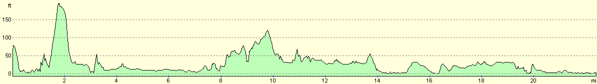
For more information on profiles, ascents and descents, see this page
Accommodation
We spent the night at the Bardsea Leisure Park, Priory Road, Ulverston, Cumbria LA12 9QE. They can be contacted on (01229) 584712. This was a nice little site that had some excellent facilities, although it was a little crowded with caravans.
Disclaimer
Please note that I take no responsibility for anything that may happen when following these directions. If you intend to follow this route, then please use the relevant maps and check the route out before you go out. As always when walking, use common sense and you should be fine.
If you find any information on any of these routes that is inaccurate, or you wish to add anything, then please email me.
All images on this site are © of the author. Any reproduction, retransmissions, or republication of all or part of any document found on this site is expressly prohibited, unless the author has explicitly granted its prior written consent to so reproduce, retransmit, or republish the material. All other rights reserved.
Although this site includes links providing convenient direct access to other Internet sites, I do not endorse, approve, certify or make warranties or representations as to the accuracy of the information on these sites.
And finally, enjoy your walking!
This walk was mentioned in the following routes:
| My walk around the coastline of Britain |
Nearby walks
| # | Title | Walk length (miles) |
|---|---|---|
| 427 | Overton to Silverdale | 19.9 |
| 428 | Silverdale to Grange-over-Sands | 22.2 |
| 430 | Ulverston Sands to Robin Whins Point | 18.0 |
|
|

|