Walk #495: Laudale to Salen via Strontian
 |
 |
|
General Data
| Date Walked | 10/07/2003 |
| County | Highlands |
| Start Location | Laudale |
| End Location | Salen |
| Start time | 10.06 |
| End time | 17.24 |
| Distance | 16.9 miles |
| Description | This was a straightforward and uncomplex walk along public roads, with some lovely views along Loch Sunart. |
| Pack | Today I carried my 30-litre Karrimor HotRock rucksack, which was filled with my packed lunch, waterproof leggings, water bottle and a couple of spare shirts, together with the usual assortment of odds and ends. |
| Condition | I feel absolutely fine after this walk, and have no major problems to report. The biggest problem that I have had is with my right shoulder, which ached occasionally, but fortunately it was not as bad as it has been. |
| Weather | It rained all night last night, so it was with some annoyance that I set off this morning into a wet sky filled with cloud. By this time the heavy rain had ceased and had been replaced with a light rain. After a couple of hours this ceased, and aside from a short shower it remained dry for the rest of the day. There were occasional glimpses of the sun, but these were short and not very prolonged, and at times the wind was fairly strong. |
| OS map | Landranger number 49 (Oban & East Mull) and Landranger number 40 (Mallaig & Glenfinnan, Loch Shiel) |
 |
 |
|
 |
 |
|
Map of the walk
Maps courtesy of Google Maps. Route for indicative purposes only, and may have been plotted after the walk. Please let me have comments on what you think of this new format. For a detailed table of timings for this walk, please see the table file.
 |
Notes
I woke up this morning to the familiar sound of rain drumming on the roof of Mervan. This was fairly depressing, as I had hoped that today would be dry. On the other hand, I knew that today involved nothing more complex than road walking, so at least I would not be struggling over rough ground such as the terrain that I encountered yesterday.
The forecast was for the weather to improve as the day went on, and so I decided to start the walk later than I had been planning to give it as much time as possible to clear. By ten the rain had stopped and been replaced with a heavy drizzle, and so I set out. The underside of my feet were aching slightly from wearing my new boots yesterday, and so despite the wet weather I decided to wear my trainers - they can be reasonably comfortable even if they get wet, and would be easier on my feet than the boots.
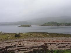
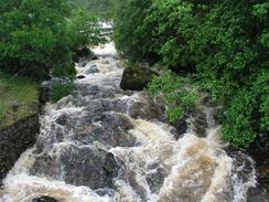
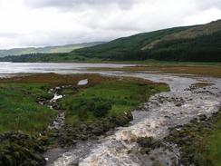
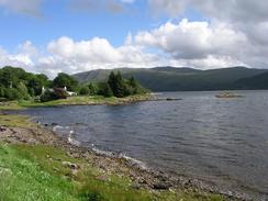
Despite the weather I quite enjoyed the walk along he southern bank of Loch Sunart. The road was not too busy, and I found that I could walk reasonably fast without overstressing my body. The only downside of the weather was that I could not take as many photographs as I wanted, which considering the number of photos that I take is probably no bad thing! Because of the heavy rain that we had overnight all the streams down the hillsides were flowing fast, and the noise that they made was quite loud. I have always loved the sight of rushing water (except when I have to ford it!), and I stopped at some of the streams and burns sp that I could watch their inexorable flow down to the sea.
I had some work that I wanted to do on the Internet, and the library in Strontian has some computers at which the public can surf. Sam had booked me in for one o'clock, and so I had to get there in time. In the end I arrived there quite early, so I got the opportunity to have a little look around the Tourist Information office before Sam drove me to the library, which is a short distance out of town in the high school complex. On checking my emails I found out that someone had kindly mentioned my website on the forum pages of the Rambler's Association website, and another man had put some very kind comments as well. I replied to these, and also posted an article on the uk.rec.walking newsgroup. There were also some fairly interesting emails awaiting me, and I answered these as well. Sam had booked the computer for an hour, but I could easily have spent much longer than this if I had the time - I shall have to wait until I reach Mallaig to do some more work.
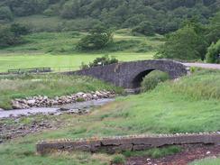
Strontian itself was quite nice, and it was not overly commercialised as many villages are in the parts of the highlands with Munros. The village used to have lead mines above it, now disused, that produced feldspar, mica, and a mineral called Srontianite, from which the element strontium was extracted. The village was also home for a few years last century of a floating church. When the Church of Scotland split one congregation needed a church, but the local landowner, who was Church of Scotland, refused to give them any land to build one. To get around this problem they built a church with over 100 seats on a barge, and moored it in the loch! The rest of the walk to the campsite at Resipole was a very straightforward and unexciting walk along the A861 road. This was mainly a single carriageway road with passing laces, as many of the main roads have been recently, but the traffic was not too heavy and I never felt endangered by the cars.
One event brightened up this otherwise boring trudge - on my way towards the campsite at Resipole I was passed by an open-top car with two men in it. They pulled over, and I chatted to them for a while and they gave me a donation. I set off once again, and a quarter of a mile further on down the road they had pulled up. One of the men had a Ipaq handheld computer with GPRS connection, and he was surfing my website from it! I as quit surprised that they could get a GPRS connection (which is a relatively new technology) in n area this remote, especially when traditional digital cell phone signals are quite weak. Once I had reached the campsite I decided that I had not walked far enough, and so I arranged for Sam to met me in an hour at Salen, which made for a slightly more decent mileage walked. A great deal of forestry work is being done in this area to protect the broad leaved forest, and visitor areas and hides are being constructed in various places, which is good to see.
As I generated the map of my walk on the computer tonight, I was amused to see exactly how far southwest of Fort William I was. In a way it is rather depressing; I have been travelling northward for such a long time (since the Lizard in Cornwall), and to end up further south than I was a week ago is strange. The west coast of Scotland has been characterised by these southerly diversions (the worst being the walk down Loch Fyne to the Mull of Kintyre), but from now on the vast majority of the lochs on the west coast will flow east to west, oinstead of northeast to southwest, and this should make progress seem faster.
Tomorrow I shall be reaching Ardnamurchan Point, which is the westrenmost point on the British mainland. I have done two of the three other cardinal points so far on this trip, and only have the northernmost point, at Dunnett Head near John O'Groats, to do after tomorrow. The last one I reached was the Lizard in Cornwall (the southernmost point on the mainland), and that was back in late January! It has taken me nearly six months to work my way this far up the west coast.
Directions
This walk starts off at the end of the public road that leads from Liddesdale towards Laudale House. Head eastwards along this road, passing an old quay, and then climbing up and down through Liddesdale and reaching a junction with the A884 road. At the junction turn left and walk eastwards along the road for a few miles along the southern bank of Loch Sunart until it reaches the end of the loch and a junction with the A862 road.
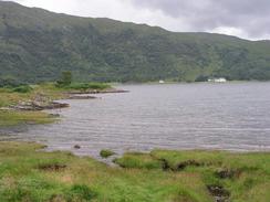
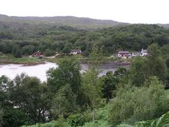
At the junction turn left and walk westwards along the A861 road. After a mile and a half it enters the village of Strontian. Continue on along the road through the village, and then on westwards out of the village along the northern bank of Loch Sunart. After a few miles the road passes the campsite at Resipole, and three miles further on it reaches a car park above the village of Salen, where this walk ends.
Distances
| From | To | Distance (m) | Ascent (ft) | Descent (ft) |
|---|---|---|---|---|
| Laudale | Strontian | 7.6 | 833 | 846 |
| Strontian | Salen | 9.3 | 1404 | 1329 |
This makes a total distance of 16.9 miles, with 2237 feet of ascent and 2175 feet of descent.
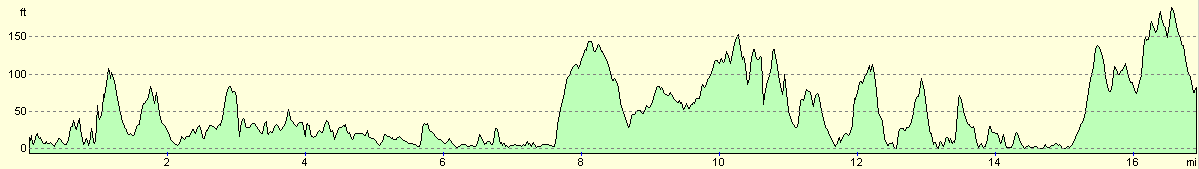
For more information on profiles, ascents and descents, see this page
Accommodation
We spent the night at the Resipole Farm caravan and camping park, , Loch Sunart, Acharacle, Argyll PH36 4HX. They have a website at www.resipole.co.uk, and they can be contacted by phone at (01967) 431235. This site was very clean and tidy, and has a bar, restaurant and golf course adjacent. It should have cost us eleven pounds for the night, but they very kindly gave it to us for six pounds.
Disclaimer
Please note that I take no responsibility for anything that may happen when following these directions. If you intend to follow this route, then please use the relevant maps and check the route out before you go out. As always when walking, use common sense and you should be fine.
If you find any information on any of these routes that is inaccurate, or you wish to add anything, then please email me.
All images on this site are © of the author. Any reproduction, retransmissions, or republication of all or part of any document found on this site is expressly prohibited, unless the author has explicitly granted its prior written consent to so reproduce, retransmit, or republish the material. All other rights reserved.
Although this site includes links providing convenient direct access to other Internet sites, I do not endorse, approve, certify or make warranties or representations as to the accuracy of the information on these sites.
And finally, enjoy your walking!
This walk was mentioned in the following routes:
| My walk around the coastline of Britain |
Nearby walks
| # | Title | Walk length (miles) |
|---|---|---|
| 491 | Camusnagaul to Inversanda | 17.0 |
| 492 | Inversanda to Clounlaid | 16.2 |
| 493 | Clounlaid to Bunavullin | 20.1 |
|
|

|