Walk #494: Bunavullin to Laudale
 |
 |
|
General Data
| Date Walked | 09/07/2003 |
| County | Highlands |
| Start Location | Bunavullin |
| End Location | Laudale |
| Start time | 08.25 |
| End time | 18.21 |
| Distance | 24.6 miles |
| Description | This was a very long walk, some of it along rough tracks and paths. |
| Pack | Today I carried my 30-litre Karrimor HotRock rucksack, which was filled with my packed lunch, waterproof leggings, water bottle and a couple of spare shirts, together with the usual assortment of odds and ends. |
| Condition | I am absolutely shattered after this walk, which is to be expected considering some of the terrain that I had to go over. On a positive note my calves gave me absolutely no trouble, and my ankles were fine. Unfortunately my right shoulder ached occasionally over the last ten miles, but this was enough to annoy me, but not worry me too much. |
| Weather | The forecast was for a little rain today, but fortunately this did not come to pass. Within a quarter of an hour the sun was out and I had to take my coat off. The sun did not last long and was replaced with cloud, but it still got quite warm nonetheless. All in all it was a beautiful day for walking. |
| OS map | Landranger number 47 (Tobermory & North Mull), Landranger number 49 (Oban & East Mull) and Landranger number 40 (Mallaig & Glenfinnan, Loch Shiel) |
 |
 |
|
 |
 |
|
Map of the walk
Maps courtesy of Google Maps. Route for indicative purposes only, and may have been plotted after the walk. Please let me have comments on what you think of this new format. For a detailed table of timings for this walk, please see the table file.
 |
 |
|
Notes
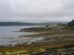
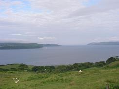
I realised that I had a long walk to do today, so I set off relatively early so that I could make the most of the day. The fist part of the walk was along a good track, and it gave some beautiful views, initially westwards over the island of Mull, and later on northwards over the little island of Oronsay. The latter in particular was fairly spectacular, and I stopped for a few minutes so that I could soak in the views.
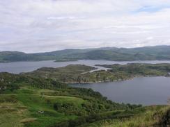
The track ended by the little cottage at Doirlinn, and from here I was forced to make my way for a couple of miles southwards along the shore of Loch Teacuis. Initially I tried to make my way long he shoreline, but this proved to be too difficult and so I headed through the forest above. Progress was slow, and my heart deepened when I was faced with a deer fence. Fortunately a little exploration found a lift-gate through the fence, and so I could continue on the other side. Eventually when I neared the bay at Poll Achadh Luachrach I descended down to the foreshore, which was less steep in the bay, and made my way round to the Barr River and the track that started beside it. I made good time along the forest track to the end of the public road near Kinloch, and I enjoyed the views along Loch Teacuis. I then sat down for a short and well-deserved lunch break, only to find that all my sandwiches had been squashed into a soggy sweet ball, which I enjoyed tucking into.
One of the things that surprised me about this walk was that there were some lovely cast-iron milepost along it. These were far more ornate than the ones along the main road, and counted the distance from Drimin to Doirlinn. They seemed quite remarkably out of place, and this made me think that this track - now barely passable by four wheel drives, must have had some supreme importance in bygone days. It is quite hard to se what this may have been, though - surely they could not have been erected to make the distance to the one cottage that now exists at Doirlinn?
With hindsight I should really have ended the walk here and split today's walk into two separate days; if I had walked three miles less yesterday it would have made today into a fifteen mile day; and I could have done the walk from Kinloch to Laudale the next day. This would have made the walk into a much better split, but I made the choice to do the walk in one day, and I had to complete it. At least it has improved my confidence about doing the Knoydart sections, as long as my shoulder can cope with the weight.
On the map there seemed to be no practical way of getting around the northern side of Loch Teacuis, as once the track ends at Rahoy there is no path, and the way is covered in hated forestry plantations in many places. For this reason I resolved to climb from Carnliath along the path that leads northern over the Bealach Sloc an Eich to Gelncriesdale on the shore of Loch Sunart. The initial climb was quite fierce, although I found that the way forward was marked with the wheel tracks of a four-wheel buggy, which made navigation simple, and I was glad to reach the top of the bealach at about 300 metres above sea level. Just before I reached the top I came across a pair of binoculars on the path. They were of good quality, and had lain there for at last a day as they were soaking wet from rain. They had no distinguishing marks on them, and so I picked them up and took them down with me - we shall try and find the owners later. The descent was, if anything, even worse, although it was well marked with Scottish right of Way Society markers. The going was very steep and he path was exceedingly indistinct, so I took my time and care on the descent.
From Glenscripesdale the going was very easy, along a good quality forest track that did not rise or fall too much. I was exceedingly tired by this time, and I found that the stony rack was causing my feet to ache - obviously my new pair of boots are not fully broken in yet. Occasionally I got good views over Loch Sunart, but for much of the time the vegetation growing between the loch and the track obscured these. I could really have done without this last eight mile plod - I only wish that Sam could have picked me up at Glencripesdale, but there was no way that she could have got Mervan there.
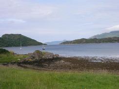
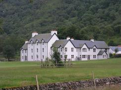
A couple of hours before I finished the walk I started to run out of water, and so I started to ration it. Unfortunately this did not work, and when I still had an hour left to go I ran out. There were some streams where I could have filled the water bottle, but as I was going to be meeting Sam soon I was not too bothered. Laudale House is very big and a lovely white building, and I walked along the foreshore past it. From there I could just make out the top box of Mervan in the distance, and I strode on for the short remaining distance (she was parked at the end of the public road near Laudale House). I passed a field with highland cows and calves in it, and next door to it was a field with stags in it. This made for a lovely sight, and I took some photographs before moving on. Sam was another couple of hundred yards further on, and she was waiting like a goddess with a beaker of water for me. I sculled this down in one, and she got me another whilst I slowly pulled all my gear out. I was more than a little knackered, and I flopped into Mervan whilst she drove the couple of hundred yards to the jetty, where there was room for us to park for the night.
Directions
This walk starts off at the jetty by Port nam Freumh in the village of Bunavullin. Head back along the B849 road for a couple of hundred yards until just before the bridge over the Abhainn Mhungasdail, where a track leads off to the left. This track heads northwestwards towards Drimin House, and just before it reaches the house the path is diverted off into a field on the right to skirt around the grounds of the house for a few hundred yards, before it rejoins the track. Continue on along the track, which slowly climbs uphill past Cnoc na Staing, shortly after which it turns to head eastwards past Sornagan, and eventually ends at the cottage at Doirlinn.
From Doirlinn you are forced to walk along the coast to the first track in the forest. The gap is a little over two miles long, but it is unpathed. Do not go down onto the foreshore but keep slightly inland until you reach a forested area, which is guarded by a deer fence. There is a lift gate in the fence, and this can be used to enter the woodland. Fight your way southwards through the woodland until the borders of the bay at Poll Achadh Luachrach is reached. Here as the tide was low I could join the foreshore and walk around the edge of the bay until I met the outfall of the Barr River. Turn right and walk up the western bank of the river until a track starts, and follow this track southwards for a short distance until a bridge over a river is reached.
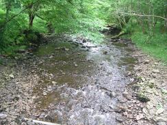
Turn left and cross the bridge, and carry along the track eastwards along the southern bank of Loch Treacuis. After a few miles near Ardantiobairt the track forks; take the lower fork and continue along the track until it reaches the end of the public road. Turn left to had north along another track, and just after this crosses the River Kinloch turn left to head westwards for a little over a mile along the northern bank of the loch. When a cottage is reached on the right turn right along a track that heads uphill past the cottage, heading eastwards. The track is quite indistinct, little more than two wheel ruts in the undergrowth, but it was fairly easy to follow to the Beallach sloc an Eich. At the bealach join a path (marked by posts) that heads northwards. The descent is quite steep, and follows the western bank of a stream downhill, entering an area of woodland. As the gradient slackens at the bottom the path crosses the stream, and shortly afterwards emerges at a bridge over the Glencripesdale Burn.
Cross the bridge and then continue on along the track, as it passes a jetty and skirts the coast around past the cottages at Camas Salach and on to the point at Rubha Aird Earnaich, where it turns to head southeastwards. It passes a bay at Camas na h-Airbhe, where there is a fish farm, and the track continues on to climb uphill slightly past Aird Beitheach before eventually turning to reach Laudale House. A sign asks you not to walk through the immediate ground of the house but to follow the foreshore, which I was glad to do for the short distance until it meets the track once more. A few hundred yards further on the track becomes a public road, and this is where this walk ends.
Distances
| From | To | Distance (m) | Ascent (ft) | Descent (ft) |
|---|---|---|---|---|
| Bunavullin | Kinloch | 12.3 | 1827 | 1811 |
| Kinloch | Glencripesdale | 3.7 | 1283 | 1263 |
| Glencripesdale | Laudale House | 8.6 | 1434 | 1467 |
This makes a total distance of 24.6 miles, with 4544 feet of ascent and 4541 feet of descent.
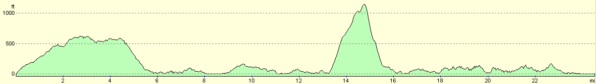
For more information on profiles, ascents and descents, see this page
Accommodation
We did not fancy driving back down the road to find somewhere to park, so we parked Mervan on the road by the jetty, a short distance away from where I ended the walk. There were absolutely no facilities in the area, but the views over Loch Sunart were absolutely superb.
Disclaimer
Please note that I take no responsibility for anything that may happen when following these directions. If you intend to follow this route, then please use the relevant maps and check the route out before you go out. As always when walking, use common sense and you should be fine.
If you find any information on any of these routes that is inaccurate, or you wish to add anything, then please email me.
All images on this site are © of the author. Any reproduction, retransmissions, or republication of all or part of any document found on this site is expressly prohibited, unless the author has explicitly granted its prior written consent to so reproduce, retransmit, or republish the material. All other rights reserved.
Although this site includes links providing convenient direct access to other Internet sites, I do not endorse, approve, certify or make warranties or representations as to the accuracy of the information on these sites.
And finally, enjoy your walking!
This walk was mentioned in the following routes:
| My walk around the coastline of Britain |
Nearby walks
| # | Title | Walk length (miles) |
|---|---|---|
| 492 | Inversanda to Clounlaid | 16.2 |
| 493 | Clounlaid to Bunavullin | 20.1 |
| 495 | Laudale to Salen via Strontian | 16.9 |
|
|

|