Walk #238: Robin Hood's Bay to Cayton Bay via Scarborough
 |
 |
|
General Data
| Date Walked | 17/10/2002 |
| County | North Yorkshire |
| Start Location | Robin Hood's Bay |
| End Location | Cayton Bay |
| Start time | 08.05 |
| End time | 16.42 |
| Distance | 18.7 miles |
| Description | This was a very nice coastal walk along cliffs, following the Cleveland Way. |
| Pack | Today I carried my 30-litre Karrimor HotRock rucksack, which was filled with my packed lunch, waterproof coat, water bottle and a couple of spare shirts, together with the usual assortment of odds and ends. |
| Condition | Yet again I feel absolutely fine after this walk, and have no physical problems. I am fairly fatigued, but nothing out of the ordinary for a walk of this length over this sort of terrain. |
| Weather | As soon as I got down to Robin Hood's Bay this morning the heaven's opened, and I got a good soaking in abut ten minutes. Fortunately after this the rain stopped and I slowly dried out. After this there were a few sunny periods, although most of the say was overcast, before another short (and lighter) shower occurred about half an hour from the end of the walk. The wind was thankfully less fierce than it had been yesterday, when it had been a big problem. |
| OS map | Landranger number 94 (Whitby & Esk Dale, Robin Hood's Bay) and Landranger number 101 (Scarborough, Bridlington & Filey) |
 |
 |
|
 |
 |
|
Map of the walk
Maps courtesy of Google Maps. Route for indicative purposes only, and may have been plotted after the walk. Please let me have comments on what you think of this new format. For a detailed table of timings for this walk, please see the table file.
Notes
As soon as I got down to the bottom of the hill in Robin Hood's Bay this morning I realised that I had forgotten my walking poles. It was pointless phoning Sam up to drop them off as I figured that I could manage without them, which I did. The terrain did not make it easy, however, as the mud on the first section was not thick but fairly slippy, and slipping on cliff-edge paths is not a wise thing to do. The lack of poles also made descents slower than they would otherwise have been, particularly on the slippery stone steps of some of the descents that I had to tackle today.
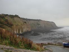
Robin Hood's Bay is a beautiful little village, with steep, narrow cobbled streets and houses that seem to loom over me as I walked down the hill. The foreshore in front of Robin Hood's Bay is exceedingly distinctive, with a large wave-cut platform and ridges of harder rock, locally called Scars, jutting out towards the sea. It makes for quite a nice and unusual effect, and apparently the area is a Mecca for geologists - not only is there the platform, the area is also famed for fossils. Glacial erratic boulders are also to be found on the platform, and a large fault line is also visible. The whole effect is quite wonderful, although I can imagine that people who finish the Coast-to-Coast walk here are less bothered about the scenery than getting their boots wet in the North Sea.
The tide was out once I got down to the village, and so instead of following the clifftop path southwards I walked along the beach as far as Boggle Hole, where the beach ends and the rocky scars take over. The Trail descends into Mill Beck at this point, so it was easy to climb up to the footbridge over the Beck and rejoin the trail. There then followed a nice clifftop walk, descending down after a short distance to cross Stoupe Beck by a footbridge before climbing up to the heights once more. The path eventually reaches Ravenscar, a small village that was meant to be much larger and to rival Scarborough, but the development failed and all that is left of the scheme are a few houses and a hotel. I must admit that the stretch to Ravenscar was not my favourite walk, and I felt slightly down, although I have no idea why this may have been.
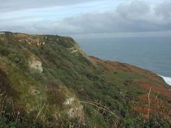
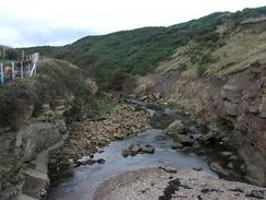
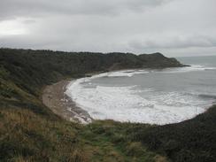
After Ravenscar, however, the trail become exquisite as it sticks to the high cliffs southeastwards. The views either way along the cliffs were superb, and I felt spiritually as if I was in heaven - a great, soaring feeling. The trail felt as if it was in a very wild and remote place, despite the fact that there was a cycle path and a road less than a mile inland. My spirits soared as I walked past the scrub woodland at the top of Beast Cliff, before eventually descending down through a wooded glade to the stream at the bottom of Hayburn Wyke. The area around the Wyke was quite magical, and I wish that I had stayed longer to explore it, as apparently there is a waterfall a short distance away. The walk called me onwards, however, so I climbed up through the woodland on the southern side of the Wyke to gain access to the clifftop path.
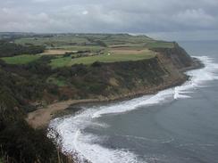
The trail leads on along cliffs that are lower than those on the northern side of Hayburn Wyke, and consequently seem less remote and wild. I soon found myself skirting around Cloughton Wyke to Hundale Point, from where the path heads south towards Scarborough. Ina couple of places the path had been eroded away slightly, meaning that I had to make small diversions inland to walk around the slips. Eventually I reached the headland at Scalby Ness, which was a lovely place, with some great views south towards Scarborough and north back along the cliffs. I soon found myself crossing the River Derwent below Scalby Ness and passing Scarborough sea life centre, to reach the North Bay at Scarborough.
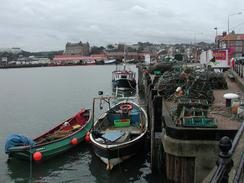
I have never been to Scarborough before, and the walk south along the promenade towards the castle was nice enough, with some attractive buildings beside the promenade. It had been my intention to walk along the Marine Drive around the headland below the castle, but I was dismayed to find that this was shut due to over-running sea defence works. When I finally reached the headland I had no choice but to cut across it, climbing up the hill past the castle (which still has a very impressive curtain wall around it) and then dropping down on the other side to reach the harbour in South Bay. The harbour area of Scarborough was quite nice, but I had not moved far from it before I got a full-frontal assault on all that is bad about British seaside resorts - end to end amusement arcades, all virtually empty, garish signs and small, pokey gift sops. The South Bay area was radically different to the North Bay, and I was shocked by quite how bad Scarborough was. I walked dazed past the Grand Hotel, where I found some semblance of civility. Indeed, once I had passed the spa I actually found some nice formal gardens, complete with palm trees, and I actually found myself enjoying the walk once more.
The last stretch of the path took me southwards on low cliffs, which on some places gave good views northwards back to Scarborough. The walk along the edge of the cliffs was not as nice as those early in the days, but after South Bay in Scarborough anything is an improvement, and I enjoyed the stroll immensely. I soon reached White Nab and from there the walk became more interesting, skirting some woodland before entering it near Osgodby point. This marks the northern end of the beach beside Cayton Bay, but instead of descending to the beach the trail winds up and down the hillside. I had arranged to meet Sam at the A165 road in Cayton, so when I met a track that headed uphill I took it, passing a field filled with Highland Cows before reaching the road, where Sam was waiting for me.
As of today I have now walked over 1,000 miles this year (actually the figure is 1,013 miles as of the end of today's walk). This is a great feeling, particularly as I only just missed this milestone in 2000 after meeting Sam and having my priorities subtly changed. It may be possible to increase this figure to over 2,000 miles this year if I continue to walk at the present rate, but the oncoming winter and the shorter days may put paid to this ambition.
Directions
This walk follows the Cleveland Way, a National Trail. The directions for this stretch of the walk can be found in the Ordnance Survey National Trail Guide 3, Cleveland Way (ISBN 1-85410-606-6). This guidebook has many notes and 1:25,000 strip maps of the route, so there is little point in my replicating them. The exception is in Scarborough, where I partially followed the Marine Drive around the headland, before climbing up to pass the castle and descending to reach the East Harbour.
Distances
| From | To | Distance (m) | Ascent (ft) | Descent (ft) |
|---|---|---|---|---|
| Robin Hood's Bay | Hayburn Wyke | 7.7 | 1804 | 1759 |
| Hayburn Wyke | Scarborough Grand Hotel | 7.6 | 1385 | 1614 |
| Scarborough Grand Hotel | Cayton Bay | 3.4 | 653 | 518 |
This makes a total distance of 18.7 miles, with 3842 feet of ascent and 3891 feet of descent.
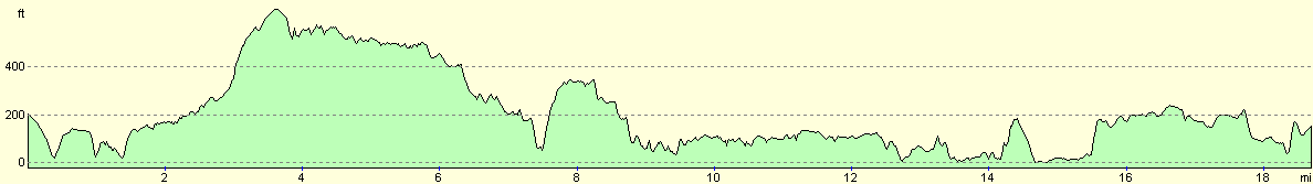
For more information on profiles, ascents and descents, see this page
Accommodation
We stayed at Browns Caravan Pak, Mill Lane, Cayton Bay, Scarborough YO11 3NN, telephone (01723) 582303, or look on the web at www.brownscaravan.co.uk or email info@brownscaravan.co.uk. This site cost us ten pounds for the night, and was reasonably well equipped, although was not as good a site as some we have stayed at.
Disclaimer
Please note that I take no responsibility for anything that may happen when following these directions. If you intend to follow this route, then please use the relevant maps and check the route out before you go out. As always when walking, use common sense and you should be fine.
If you find any information on any of these routes that is inaccurate, or you wish to add anything, then please email me.
All images on this site are © of the author. Any reproduction, retransmissions, or republication of all or part of any document found on this site is expressly prohibited, unless the author has explicitly granted its prior written consent to so reproduce, retransmit, or republish the material. All other rights reserved.
Although this site includes links providing convenient direct access to other Internet sites, I do not endorse, approve, certify or make warranties or representations as to the accuracy of the information on these sites.
And finally, enjoy your walking!
This walk was mentioned in the following routes:
| My walk around the coastline of Britain |
Nearby walks
| # | Title | Walk length (miles) |
|---|---|---|
| 237 | Runswick Bay to Robin Hoods Bay | 14.9 |
| 239 | Cayton Bay to Flamborough North Landing via Filey | 16.9 |
| 962 | Cleveland Way: Boulby Cliffs to Robin Hood's Bay | 21.2 |
|
|

|