Walk #240: Flamborough North Landing to Mappleton
 |
 |
|
General Data
| Date Walked | 19/10/2002 |
| County | Humberside |
| Start Location | Flamborough North Landing |
| End Location | Mappleton |
| Start time | 08.15 |
| End time | 17.36 |
| Distance | 23.1 miles |
| Description | This was a lovely combination of cliff and beach walking south from Flamborough along the Humberside coast. |
| Pack | Today I carried my 30-litre Karrimor HotRock rucksack, which was filled with my packed lunch, waterproof coat, water bottle and a couple of spare shirts, together with the usual assortment of odds and ends. |
| Condition | I am fine after this walk, aside from a little fatigue. This is a very good sign after such a long walk, and I am hopeful that I may be able to do another long distance tomorrow. I still have no blisters and my body generally feels okay. |
| Weather | The weather today was the best for over a week, with no sign of any rain and not much wind to bother me. The majority of the day was sunny, with cloud for some of the time. It was quite warm in the sun, although in the shade it could still be a little chilly, particularly if the wind caught me. |
| OS map | Landranger number 101 (Scarborough, Bridlington & Filey) and Landranger number 107 (Kingston upon Hull & surrounding area) |
 |
 |
|
 |
 |
|
Map of the walk
Maps courtesy of Google Maps. Route for indicative purposes only, and may have been plotted after the walk. Please let me have comments on what you think of this new format. For a detailed table of timings for this walk, please see the table file.
Notes
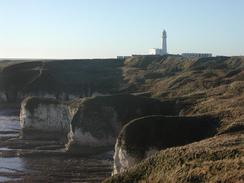
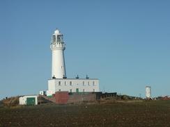
I set off from Flamborough feeling quite confident, and looking forward to what promised to be an interesting day's walk. The weather certainly looked promising, with bright blue skies, although this was accompanied with a certain chill in the air. As I walked around the first stretch of cliffs from the car park I got a better view down into North Landing than I did last night, and the sight of the cobles drawn up on the steep slope was lovely. A good and easy to follow path took me on to the lighthouse at Flamborough Head, which was bustling with people, despite the fact that it was not yet nine in the morning. The lighthouse itself was very nice, being a tall example, towering above the surrounding buildings. I soon bade farewell for the lighthouse and followed the path around to South Landing. Here I was tempted to walk on northwards into Flamborough to have a look around, but I decided against it and continued on. The climb up past the lifeboat station in South Landing was quite tough but the views south more than made up for the exertion, and the path westwards along the clifftop was superb. Past Danes Dyke a little gully had to be negotiated (thankfully with steps), but after this the going became much flatter as I passed near to Sewerby Hall. Between the hall and myself people were playing football and cricket; the first game of cricket that I can recall seeing on the trip so far.
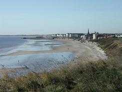
Sam was waiting for me in Bridlington, and the first order of the day was to find an Internet cafe. Neither of us had checked our accounts for some time, and I was eager to use the opportunity of finding a large town in which there would be an Internet Cafe. There was nothing of any urgency to deal with, and the costs of the cafe were too expensive for general web browsing, so we left and found a local pub where I had a pint and a snack to eat. Sam was on good form, and we ended up chatting to a local couple in the pub that were soon dipping into their pockets to give us a donation. Such hospitality was very kind, and it was with regret that I left the pub and walked back to the harbour so that I could restart the walk. Bridlington itself was quite nice, and was not overly commercialised (particularly when compared to the horrors of Scarborough), and there were some fine buildings alongside the promenade.
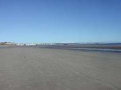
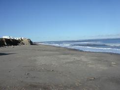
What followed was a seemingly endless long plod southwards along a beach. The tide was coming in and so I knew that I would not be able to walk as far as Hornsea along the sands, but for the moment they would do. Near Bridlington the beach was full of activity; people playing in the water, walking along and even a few wind-powered sand buggies, which scampered to and fro along the beach. As I walked, however, I left the crowds behind and I started to really enjoy the walk. I had expected such a long stretch of beach to be fairly boring but it was surprisingly enjoyable, although having the low and crumbling cliffs on my right as I walked got slightly grating after the first five or so miles. It was very peaceful, however, and so I just put myself onto autopilot and walked along.
Near Skipsea I met a lady who was fishing and I had a little chat with her. There was a dead seal a little way down the beach, a victim of the distemper that is ravaging the population. She also told me that the tide was coming in and the next part of beach may well be impassable, so heeding her advice I climbed up onto the clifftop path. Near the end of the day, on the walk between the MOD firing range and Mappleton, I came across two council workers who were trying to get a dead seal, another victim of the distemper, out of the water at the bottom of the cliff. Seeing the body of the seal amongst the usual flotsam and jetsam made for a very sad sight. Shortly after I met the lady I realised that the tide was coming in ever closer to the base of the cliffs, and so I decided that caution was needed, and so I had an enjoyable scramble up a gully to reach the path at the top of the cliffs.
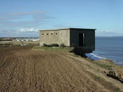
Once I got onto the top of the cliffs the erosion was clear to see; in places buildings were perched precariously half-on and half-off the edge; I ventured into one of these, and old Second World War blockhouse, and actually stood on the concrete floor over the edge of the cliff. This was a quite unnerving feeling, but I had confidence that there was enough of the building still on the ground for it to be safe. In other place roads ended abruptly at the edge of the cliffs, and in a caravan site there were concrete bases that had once housed caravans broken in two at the cliff edge. It was all very interesting, and made the walk along the cliff tops far more interesting than the walk along the beach had been. Sam was waiting for me in Hornsea, and we stopped for a while and had a packet of chips before I set off once again.
I had only been intending to walk as far as Hornsea, but I felt so good when I got there that I decided to walk on to Hornsea, and when I got there I still felt good and so I decided to extend the walk yet again, this time to Mappleton. This was probably a good job, as this last section of the walk passed an MOD firing range which fires Tuesday to Sunday, 8 a.m. to 4 p.m. Since I was passing at about 16.45 I could walk through along the (unofficial) cliff top path unhindered, but if I had left it to the morning I may have been blocked from walking this stretch. I really did not like the look of the inland diversion around the range, and so I was glad that the clifftop route was available.
Directions
This walk starts off at the car park at Flamborough North Landing, which is at the end of the B1255 road. Leave the car park and follow a footpath that heads southeastwards along the edge of the cliffs past Cradle Head and on to a track that leads down to the prominent lighthouse at Flamborough Head. Continue on the track past the lighthouse and a car park, and then turn to the right before the edge of the cliffs is reached. This path heads south to meet the clifftop near High Stacks, and then follows the edge of the cliffs on a gentle walk until a sharp drop takes you down into the South Landing.
From South Landing climb up the cliffs and head westwards along the clifftop; immediately beyond Dane's Dyke the path descends into a little valley before immediately climbing up again on the other side and heading on a more southwesterly heading through the grounds of Sewerby Hall. The footpath ends as it descends down onto a road that runs beside the sea in Bridlington. Join the road and follow it southwestwards past North Sands and then onto the harbour. Skirt past the harbour and then follow roads through Hilderthorpe; if the tide is out then you can join the beach and take this route instead.
Once south of Hilderthorpe join the beach if the tide allows, and follow the South Sands as they curve away southwards, becoming Fraisthorpe Sands. The rest of the day's walk can be walked along the massively long stretch of beach that follows, which is backed by a low but steep-faced cliff; if the tide is high then a path runs at the top of the cliffs from Ulrome southwards. You can either walk past Hornsea on the beach, or if you walked along the top of the cliffs then follow the roads south through the town. To the south of Hornsea you can either walk along a path at the top of the cliffs or along the beach, depending on the state of the tides; this walk ends at Mappleton Church, about three miles south of Hornsea; however there is a problem in the form of a rifle range. If this is operating then you will have to make a diversion inland to the B1242 and walk to Mappleton along that road.
Distances
| From | To | Distance (m) | Ascent (ft) | Descent (ft) |
|---|---|---|---|---|
| Flamborough North Landing | Bridlington | 7.7 | 1854 | 1952 |
| Bridlington | Skipsea Sands | 7.5 | 135 | 131 |
| Skipsea Sands | Hornsea | 5.1 | 335 | 335 |
| Hornsea | Mappleton | 2.8 | 105 | 62 |
This makes a total distance of 23.1 miles, with 2429 feet of ascent and 2480 feet of descent.
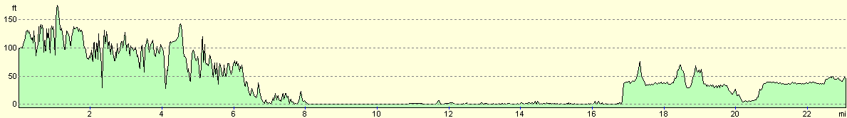
For more information on profiles, ascents and descents, see this page
Accommodation
We stayed at the Springfield Caravan Park, which is situated next to Springfield Farm just off the B1242 road to the north of Hornsea.
Disclaimer
Please note that I take no responsibility for anything that may happen when following these directions. If you intend to follow this route, then please use the relevant maps and check the route out before you go out. As always when walking, use common sense and you should be fine.
If you find any information on any of these routes that is inaccurate, or you wish to add anything, then please email me.
All images on this site are © of the author. Any reproduction, retransmissions, or republication of all or part of any document found on this site is expressly prohibited, unless the author has explicitly granted its prior written consent to so reproduce, retransmit, or republish the material. All other rights reserved.
Although this site includes links providing convenient direct access to other Internet sites, I do not endorse, approve, certify or make warranties or representations as to the accuracy of the information on these sites.
And finally, enjoy your walking!
This walk was mentioned in the following routes:
| My walk around the coastline of Britain |
Nearby walks
| # | Title | Walk length (miles) |
|---|---|---|
| 239 | Cayton Bay to Flamborough North Landing via Filey | 16.9 |
|
|

|