Walk #239: Cayton Bay to Flamborough North Landing via Filey
 |
 |
|
General Data
| Date Walked | 18/10/2002 |
| County | North Yorkshire, Humberside |
| Start Location | Cayton Bay |
| End Location | Flamborough North Landing |
| Start time | 08.35 |
| End time | 16.05 |
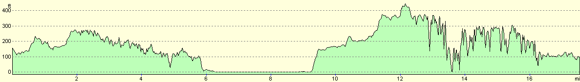
| Distance | 16.9 miles |
| Description | This was an extremely nice combination of cliff and beach walking taking in two prominent east coast headlands, Filey Brigg and Flamborough. |
| Pack | Today I carried my 30-litre Karrimor HotRock rucksack, which was filled with my packed lunch, waterproof coat, water bottle and a couple of spare shirts, together with the usual assortment of odds and ends. |
| Condition | I am okay after today's walk with no problems to report aside from a slight fatigue. I have no new blisters and am feeling absolutely fine. |
| Weather | The weather today was a mixture of sunshine and showers, with the showers all being brief but fierce. I also suffered my first hailstorm of the walk when I was on the cliffs to the north of Filey, although fortunately the hail was small and the shower did not last long. There was a fierce wind on the cliffs later on, and when this was coupled with rain I felt quite cold. |
| OS map | Landranger number 101 (Scarborough, Bridlington & Filey) |
 |
 |
|
 |
 |
|
Map of the walk
Maps courtesy of Google Maps. Route for indicative purposes only, and may have been plotted after the walk. Please let me have comments on what you think of this new format. For a detailed table of timings for this walk, please see the table file.
Notes
Sam dropped me off on the A165 road in Cayton Bay a little later than I wanted this morning, and therefore I did not delay to say hello to the Highland Cows that were grazing in the field next to the track that I took to get down to the Cleveland Way trail. I was soon rewarded with some lovely views as the path climbed up onto the top of the cliffs at the southeastern end of Cayton Bay, and I soon realised that it was going to be a most rewarding day. The path continued along the top of the cliffs before entering a caravan park, and I had to divert through the park slightly here due to some erosion of the path. This was not a major difficulty, however, and I soon got back to the proper path that I followed all the way to the promontory of Filey Brigg. Just before I reached the Brig I passed a rocket tower; this is a restored example of a feature that was at one time common on the coast; they were used to allow coastguards to practice firing rockets onto ships. One man would go onto the tower (which is supposed to resemble the mast of a ship) and the other members would attempt to fire a rocket and line at him.
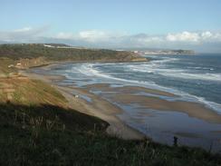
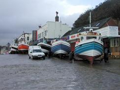
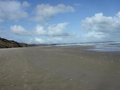
I liked Filey Brigg immensely; the path runs along the top of it, and I felt like I was a knife-edge arête in the Lake District. It was an incredibly airy place, and the views were expansive to the south over Filey and even as far south as Flamborough Head. Filey Brigg is also the end of the Cleveland Way and the start of the Wolds Way; it is a tremendous place for two National Trails to meet. I took the clifftop path down towards Filey, and descended won a track through a gully to gain access to the beach just to the north of the Coble Landing. This is where Cobles, or fishing boats, are pulled out of the water, and marks the northern outskirts of the town. I walked along the promenade through the pretty little town, and was extremely thankful that it had nit suffered the same commercialised fate as Scarborough. I sat down on a bench for a short while and saw the world pass by and the waves come crashing in, and I decided that there were far worse place to be at that particular time.
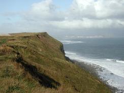
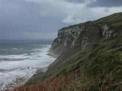
During my walk south along Humanby Beach I was concerned about getting caught out by the tide with no way up the cliffs. For this reason I decided to take a route that I knew that I could depend on up the cliffs and into the caravan park at Reighton Sands. I walked through the park and then had to find a way though the fields southeastwards to meet the clifftop path along Speeton Cliffs. I left the caravan park and walked through Low Fields to a stream that was marked on the map, but I found that the stream was steep-sided and fairly deep. I walked downstream a short distance towards some trees but realised that the banks were getting more overgrown, so I carefully made my way down and over in an operation that took a fair few minutes. I then made my way back to the sea where I found that there was a route up off the beach onto the clifftop path after all, along the Headland Way. Not only was the detour I had made unnecessary, but it had also taken a long time, been overly strenuous and highly annoying. On a positive side these were the first chalk cliffs of the trip, and it felt nice to be on such a symbol of Englishness; chalk cliffs will forever be associated with Dover, although it was nice to see that the east coast had some spectacular examples as well.
Shortly after this I received a phone call from Sam, who had been trying to set up an interview with a local radio station, Radio Humberside. The man at the station said he would phone me back in a few minutes, and so I sat down on the ground behind a stone bench to shelter myself from the wind that was making conversation hard. We chatted for a while and he recorded a segment to be used on Tuesday morning's news, and whilst this was happening I saw a rabbit come bolting out of a field to my right and run right over the edge of the cliff, which was one of the most surreal moments of my life. I have no idea what had caused the rabbit to bolt, and I can only wonder what went through it's mind as it realised that there was no ground left underneath it and it started falling.
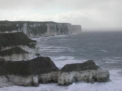
The walk from here was along some spectacular chalk cliffs, and the views were divine. The wind on these high cliffs was rather strong, but it was bearable and the views more than made up for any nuisance caused by the wind. At the trig point near Ducley Dock I stopped to make a phone call to a friend, although it was hard to hear what was being said in the high winds. The view back to Filey from here were particularly nice, although I was not keen to get too close to the edge after the fate that had befallen the rabbit. Around the nature reserve on Bempton Cliffs there were a series of platforms built right on the cliff edge, I can only surmise that these were built so that birdwatchers could see birds nesting on the sheer cliffs, but there were no hardy ornithologists on them today. As the cliffs got lower they got more interesting, with many stacks and caves to be seen. The North Landing houses a tiny slipway and a small fleet of cobbles, although all of these looked tiny compared to the cliffs that the landing nestles amongst. This marked the end of the walk, and I was glad that Sam was waiting for me in the car park at the top of the cliffs, as I was fairly tired after the superb walk.
Directions
The first part of this walk as far as Filey Brig follows the Cleveland Way, a National Trail. The directions for this stretch of the walk can be found in the Ordnance Survey National Trail Guide 3, Cleveland Way (ISBN 1-85410-606-6). This guidebook has many notes and 1:25,000 strip maps of the route, so there is little point in my replicating them.
From Filey Brig the path follows the Wolds Way for a mile south past Filey Sands into the village of Filey; if the tide is low then you can descend from the brigg onto the beach and walk along that, otherwise there is a good clifftop path. Either way, make your way to the Coble Landing on the north side of the village, and then head south along the promenade. When the promenade ends join the beach and follow it southwards along Muston Sands; if the tide is high then you may have to pick a different route along the top of the cliffs. The beach continues on for a few miles as the cliffs slowly get higher on the right. Once below the Reighton Sands Holiday Village use a path to climb up onto the top of the cliffs and enter the village.
Here things became complicated for me; I left the holiday village by walking eastwards along the top of the cliffs, but then a wooded defile blocked my way. I managed to cross this (see the notes above), and then joined the footpath that runs eastwards along the edge of Speeton Cliffs. The footpath eventually reaches a height of nearly 135 metres by the trig point at Dulcey Dock, and from here the path is easy to follow as it heads eastwards across Buckton Cliffs and passing to seaward of the visitor centre on Bempton Cliffs. The cliffs start to swing southeastwards here as they lose height, and eventually a track is reached on North Cliff. The path skirts the track before diverting away to head around Thornwick Bay, before eventually emerging at a car park Flamborough North Landing at the end of the B1255 road, where this walk ends.
Distances
| From | To | Distance (m) | Ascent (ft) | Descent (ft) |
|---|---|---|---|---|
| Cayton Bay | Filey | 6.1 | 1670 | 1814 |
| Filey | Flamborough North Landing | 11.5 | 5030 | 4944 |
This makes a total distance of 17.6 miles, with 6700 feet of ascent and 6758 feet of descent.
For more information on profiles, ascents and descents, see this page
Accommodation
We stayed at the Thornwick and Sea Farm Holiday Centre, Flamborough, East Yorkshire, YO15 1AU, Tel. 01262 850369, email enquiries@thornwickbay.co.uk, and has a website at www.thornwickbay.co.uk. This site had some lovely hot and powerful showers and cost us ten pounds and fifty pence for the night. It is right next to the path, but I had to be picked up as I walked on a short distance further than the site.
Disclaimer
Please note that I take no responsibility for anything that may happen when following these directions. If you intend to follow this route, then please use the relevant maps and check the route out before you go out. As always when walking, use common sense and you should be fine.
If you find any information on any of these routes that is inaccurate, or you wish to add anything, then please email me.
All images on this site are © of the author. Any reproduction, retransmissions, or republication of all or part of any document found on this site is expressly prohibited, unless the author has explicitly granted its prior written consent to so reproduce, retransmit, or republish the material. All other rights reserved.
Although this site includes links providing convenient direct access to other Internet sites, I do not endorse, approve, certify or make warranties or representations as to the accuracy of the information on these sites.
And finally, enjoy your walking!
This walk was mentioned in the following routes:
| My walk around the coastline of Britain |
Nearby walks
| # | Title | Walk length (miles) |
|---|---|---|
| 238 | Robin Hood's Bay to Cayton Bay via Scarborough | 18.7 |
| 240 | Flamborough North Landing to Mappleton | 23.1 |
|
|

|