Walk #241: Mappleton to Easington
 |
 |
|
General Data
| Date Walked | 20/10/2002 |
| County | Humberside |
| Start Location | Mappleton |
| End Location | Easington |
| Start time | 08.45 |
| End time | 16.23 |
| Distance | 19.7 miles |
| Description | This was a long walk along part of what must be one of the longest continuous stretches of beach in Britain, the thirty-odd miles between Bridlington and the tip of Spurn Head. |
| Pack | Today I carried my 30-litre Karrimor HotRock rucksack, which was filled with my packed lunch, waterproof coat, water bottle and a couple of spare shirts, together with the usual assortment of odds and ends. |
| Condition | Yet again I am absolutely fine after this walk, with no problems to report. I have one small blister on the middle toe of my right foot, but this did not cause me any trouble until after I took my boots off. |
| Weather | Today's weather deteriorated as the day went on, with a little early sunshine being eclipsed by cloud. A little drizzly rain occurred near the end of the walk, and about twenty minutes after I was picked up it started to rain heavily, and it continued to do so for the whole evening. |
| OS map | Landranger number 107 (Kingston upon Hull & surrounding area) |
 |
 |
|
 |
Map of the walk
Maps courtesy of Google Maps. Route for indicative purposes only, and may have been plotted after the walk. Please let me have comments on what you think of this new format. For a detailed table of timings for this walk, please see the table file.
Notes
I found this walk to be surprisingly boring, with the boulder clay cliffs to my right being so eroded that it was very hard to gain any visual reference to where I was on the beach. Indeed any one mile stretch of beach looked more or less like any other; the cliffs were the same and there was very little of interest to see on the beach. When I did start walking on the cliff tops when the tide started coming in when I was to the south of Withernsea I was happier; there were many more things of interest to see from the cliffs than there were on the beach.
When Sam dropped me off at the car park in Mappleton there was a fisherman getting his gear together prior to walking down to the beach. Hoping for some local knowledge, I asked him what time the high tide was and he replied that I should be okay for another hour. This confused me, as I reckoned the high tide had just gone and the tide would now be going out, so it was with not a little confusion that I set out on the walk. To make matters worse, the first two or three miles of beach had the words 'danger area' marked ominously over them on the map, so I was unsure if I could even walk along this stretch. I saw nothing to stop me, however, so I walked on down the beach. Indeed the only sign I saw was one warning people not to pick up unexploded ordnance; and indeed I saw a few pieces of metal on the beach, but I was not stupid enough to see if it may be unexploded or not.
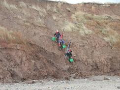
Near the end of the danger area I saw a couple of people in the distance ahead of me on the beach. As I approached I saw that one of them was wearing what looked like a camouflaged coat, so I instantly assumed that he might be military. To make matter worse, the couple were bending down and examining the ground at regular intervals. It was only when I got closer to them that I saw that it was a man and a woman, and that he was carrying a hammer and a chisel. Intrigued by this, I went over to them and ended up having a five minute chat. It turns out that he is a fossil collector, and he was looking for some ammonites on the beach. He runs a fossil shop, www.fossilshop.co.uk, on the Isle of Wight and the two of them were extremely nice indeed.
Sam phoned me up when I was about forty minutes away from Withernsea and told me that she was walking northwestwards along the coast to meet me. We eventually met up about half an hour later, and she turned around and we walked together southeastwards towards the town. As we walked I noticed that rather than just cope with the occasional areas of soft sand, she was moving from one side of the beach to the other to try and stay on the patches of loose shingle, which I thought was just as bad to walk on.
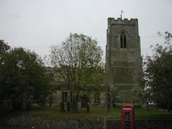
The amount of coastal erosion that there has been on this stretch of coast is absolutely amazing, and it shows just how weak the boulder clay cliffs are. At Withernsea there is a plaque on the seawall commemorating the 13th century Church of St. Mary the Virgin, the site of which is now a mile offshore and was lost to erosion in the 15th century. Easington Church at the end of the walk was also quite interesting - a plaque outside it proclaims that certain parts of it are from other churches that have been lost to the sea.
Coming up over the little hill on the walk to Dimlington I passed seven wind turbines, all turning in the slightly stiff breeze and I also got my first sight of the River Humber - I had the North Sea to my right and ahead was the estuary. It was quite a nice sight, and I stopped for a minute so that I could take in the sight. The Humber is my first major estuary that I have to cross, and it should take me a few days to do so. At least I do not have to walk as far as Goole and back like John Merrill did - the Humber bridge will save me many miles of walking.
I had arranged to met Sam at Easington Church, and when I got there I felt like I could have easily continued on for another three miles or so to Kilnsea, at the top of Spurn Head. This would have set me up well for the next day, but my heart was not really in it and so I reluctantly got into the van. A short while after this it started to rain heavily, and so I was glad of this decision.
Directions
The directions for this walk are exceedingly simple; if you catch the tides right then it may be possible to walk the entire thing along a beach. The walk starts off at Mappleton Church, about three miles southeast of Hornsea. Leave the church and head back the short distance to the top of the cliffs. If the tide is out then go onto the beach, and start following it southeastwards beside the low boulder clay cliffs. If the tide is high then you may have to take an alternative route; however there is not an obvious route until you reach Tunstall after several miles. Stay on the beach until Withernsea is reached, and then continue on southeastwards. Immediately south of Withernsea there is no clifftop path, but this soon restarts near Nevilles Farm. Continue on, either along the beach or the cliff top path (I climbed up onto the top of the cliffs after a while), and continue on to Easington. This walk ends at Easington Church.
Distances
| From | To | Distance (m) | Ascent (ft) | Descent (ft) |
|---|---|---|---|---|
| Mappleton | Withernsea | 12.8 | 46 | 10 |
| Withernsea | Easington Church | 6.9 | 325 | 331 |
This makes a total distance of 19.7 miles, with 371 feet of ascent and 341 feet of descent.
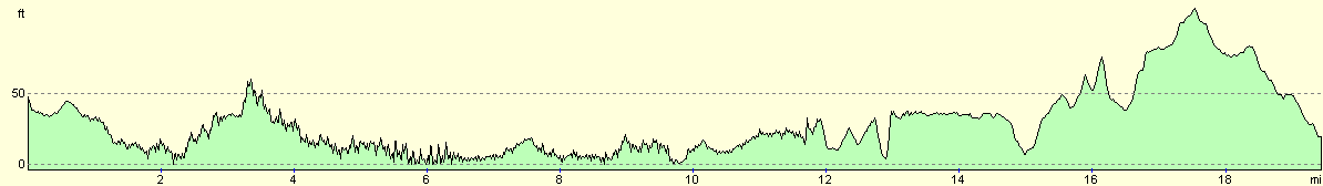
For more information on profiles, ascents and descents, see this page
Accommodation
We stayed at the St Quinton caravan site, Sandalwood, Hull Road, Easington, Hull, HU12 0TE, tel. 01964 650273. The pitch cost us six pounds for the night, although as the owners were away we had to put the money through the letterbox.
Disclaimer
Please note that I take no responsibility for anything that may happen when following these directions. If you intend to follow this route, then please use the relevant maps and check the route out before you go out. As always when walking, use common sense and you should be fine.
If you find any information on any of these routes that is inaccurate, or you wish to add anything, then please email me.
All images on this site are © of the author. Any reproduction, retransmissions, or republication of all or part of any document found on this site is expressly prohibited, unless the author has explicitly granted its prior written consent to so reproduce, retransmit, or republish the material. All other rights reserved.
Although this site includes links providing convenient direct access to other Internet sites, I do not endorse, approve, certify or make warranties or representations as to the accuracy of the information on these sites.
And finally, enjoy your walking!
This walk was mentioned in the following routes:
| My walk around the coastline of Britain |
Nearby walks
| # | Title | Walk length (miles) |
|---|---|---|
| 240 | Flamborough North Landing to Mappleton | 23.1 |
| 242 | Easington to Skeffling via Spurn Head | 14.8 |
|
|

|