Walk #242: Easington to Skeffling via Spurn Head
 |
 |
|
General Data
| Date Walked | 21/10/2002 |
| County | Humberside |
| Start Location | Easington |
| End Location | Skeffling |
| Start time | 08.20 |
| End time | 14.36 |
| Distance | 14.8 miles |
| Description | This is what should be a highly enjoyable walk taking in Spurn Head, and one that could easily be extended to encompass a whole day. If the weather is bad, however, then Spurn Head can be a cold place, as we found out today. |
| Pack | Today I carried my 30-litre Karrimor HotRock rucksack, which was filled with my packed lunch, waterproof coat, water bottle and a couple of spare shirts, together with the usual assortment of odds and ends. |
| Condition | I am absolutely fine, if a little wet, after this walk, with no real problems to report. Both of my Achilles hurt for five minutes after the prolonged lunch stop but fortunately this soon cleared up, and I had a little pain with my right knee, which was aching slightly. |
| Weather | Today was probably the wettest day of the trip so far. The day started off inauspiciously as it had rained all night and the morning shoed no signs of this letting up. The walk along the back down to the car park to meet Sam was wet and windy, but the rain stopped for our walk down to Spurn Head. Unfortunately just as we were looking for somewhere to eat our lunch at the head it started to rain heavily, and it was two drowned rats that made it back to the van. The rain eased off slightly for some of the last part of the walk, but my left boot still got soaked by many of the large puddles that lay menacingly on the path. |
| OS map | Landranger number 107 (Kingston upon Hull & surrounding area) |
 |
 |
|
Map of the walk
Maps courtesy of Google Maps. Route for indicative purposes only, and may have been plotted after the walk. Please let me have comments on what you think of this new format. For a detailed table of timings for this walk, please see the table file.
Notes
This was a highly unusual day's walk. On this trip I have become used to walking fifteen miles day and progressing what seems to be a long distance on the map; today I have walked a medium distance and only ended up a couple of miles from where I started. I should find this depressing, but in reality doing a short day was the wise thing to do, especially due to the awful weather.
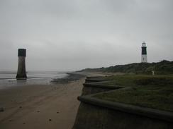
Sam joined me for the Spurn Head part of this walk, which was a really nice treat for me. The first part of the walk down to the point was dry, and we had a long chat, although the views were obscured by the general murk that lay around us. When we got to the point we started to look around, and then decided to find somewhere to sit down. There is a caravan that serves as a café, but it turns out that this is only open at weekends, but we used the benches outside it to sit down on. Unfortunately as soon as we had done so the rain started coming, and it was two very wet people who made it back to the campervan which was parked in the car park of the Bluebell visitor centre.
Although the Bluebell visitor centre was closed, it was still quite interesting as on the outside it had two little stone plaques. One of these stated 'Built in the year 1847, 534 yards from the sea', and the other stated 'Restored 1994 190 yards from the sea'. These figures show the fast rate of erosion of this section of coast, and indeed recent measures have slowed this down somewhat. These measures are now being removed, as over a long period Spurn Head has been moving slowly westwards. The measures had actually kept it further east whilst the coast eroded away to the west, which means that Spurn Head was our of line with the coast and more likely to get cut off in winter storms. The new plan is to allow it to move, and the road surface being put down in sections is made up of little concrete segments that can easily be moved when the time comes.
We than sat down to eat the rest of our lunch whilst I waited for the rain to stop. After a while it had not stopped, so I wrapped myself up in my waterproofs and set out once more. Fortunately the rain started to ease after a few minutes, and although it never really stopped it did become lighter and easier to cope with. Because of the rain I decided to not walk as far as I had been intending, and so I ended the walk at the car park which is at the bottom of a road which heads to the estuary from Skeffling.
Once we had finished the walk I was a bit of a drowned rat, and so I got out of all my wet clothes and changed into some dry ones. We then went into Easington so we could visit a shop to buy some food, and we then got told that the Crown and Anchor pub in Kilnsea, which I had passed earlier in the day, served food all day. We therefore decided to eat out rather than cook, and went to the pub. Unfortunately when we got there it turned out that we had been misinformed, and that they did not serve food all day. We stayed there for about an hour whilst I had a couple of pints and chatted to some locals.
All in all this was good but should have been brilliant, the weather letting us down in a major way. Spurn Head is a fantastic place, and I intend to come back and visit it another day when I will actually be able to see things and will not get soaked. Despite the weather I can look back on a very memorable day, and in a perverse way I would like to see it in a storm when really big waves come rolling in.
I have been asked to mention that dogs are not allowed on the nature reserve of Spurn Head, as since 1962 the Yorkshire Wildlife Trust have had a policy of no dogs on site, not even in cars. This way situations of disturbance and conflict do not arise.
Directions
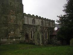
This walk starts off at Easington Church. Walk eastwards along the B1445 road out of the village. Pass the Methodist church the road curves slightly to the right and becomes a local road. When the road curves to the right once more to head southwards continue straight on down a minor road which passes a caravan site before ending abruptly at the sea.
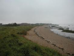
Turn right and follow the beach southwards for a couple of miles. Fairly soon the cliffs on the right become sand dunes, and some lagoons are visible on the far side of them. If the tide is high then there is a track marked on the OS map that runs slightly inland along the coast; this track was indistinct and eroded in places on the ground. Past the end of the lagoons I joined a green lane that headed south for half a mile past a caravan park until it ended at a road junction beside the Bluebell visitor centre and car park.
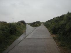
At the road junction continue straight on southwards along the tarmac road. When it starts to turn to the left there is a gate, where the public road ends and the road to Spurn Head starts. There is a little building here that is run by the Yorkshire Wildlife Trust, who collect tolls from drivers who want to drive down to the Point.
Continue on along the road and follow it for a little over three miles as it curves around to the lighthouse at Spurn Head. The ground underfoot is good, although sandy in places, and care has to be taken not to take any of the old roads that have been washed away. Having said that, the beach could easily be walked along if you wanted a different route.
Having reached Spurn Head and having explored it, turn back and head back to the Bluebell visitor centre. At the road junction turn left and walk along it for a short distance into the little village of Kilnsea. In Kilnsea the road turns to the right beside a pub called the Crown and Anchor. Just after the pub a little path heads off to the left away from the road, following the top of the sea bank northwestwards. This path passes behind a hotel (I walked along the little beach for this section), and continues on. The directions are incredibly simple; just stay on this path for about three miles until the little car park is reached beside an Environment Agency building to the south of Skeffling.
Distances
| From | To | Distance (m) | Ascent (ft) | Descent (ft) |
|---|---|---|---|---|
| Easington Church | Spurn Head visitors centre | 2.8 | 46 | 46 |
| Spurn Head visitors centre | Spurn Head | 4.1 | 50 | 50 |
| Spurn Head | Spurn Head visitors centre | 4.1 | 50 | 50 |
| Spurn Head visitors centre | Skeffling | 3.8 | 69 | 89 |
This makes a total distance of 14.8 miles, with 215 feet of ascent and 235 feet of descent.
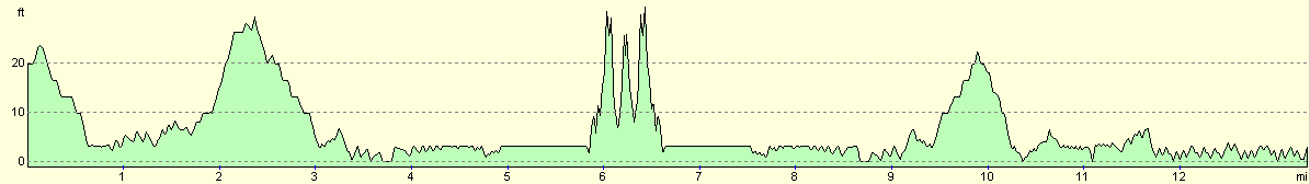
For more information on profiles, ascents and descents, see this page
Accommodation
We stayed at the St Quinton caravan site, Sandalwood, Hull Road, Easington, Hull, HU12 0TE, tel. 01964 650273. The pitch cost us six pounds for the night, although as the owners were away we had to put the money through the letterbox.
Disclaimer
Please note that I take no responsibility for anything that may happen when following these directions. If you intend to follow this route, then please use the relevant maps and check the route out before you go out. As always when walking, use common sense and you should be fine.
If you find any information on any of these routes that is inaccurate, or you wish to add anything, then please email me.
All images on this site are © of the author. Any reproduction, retransmissions, or republication of all or part of any document found on this site is expressly prohibited, unless the author has explicitly granted its prior written consent to so reproduce, retransmit, or republish the material. All other rights reserved.
Although this site includes links providing convenient direct access to other Internet sites, I do not endorse, approve, certify or make warranties or representations as to the accuracy of the information on these sites.
And finally, enjoy your walking!
This walk was mentioned in the following routes:
| My walk around the coastline of Britain |
Nearby walks
| # | Title | Walk length (miles) |
|---|---|---|
| 241 | Mappleton to Easington | 19.7 |
| 243 | Skeffling to Paull | 18.9 |
|
|

|