Walk #444: Dumfries to Southerness Point
 |
 |
|
General Data
| Date Walked | 16/05/2003 |
| County | Dumfries and Galloway |
| Start Location | Dumfries |
| End Location | Southerness Point |
| Start time | 09.23 |
| End time | 17.16 |
| Distance | 18.1 miles |
| Description | This walk was not very nice, but then again it would be very hard to have a nice walk in such awful weather. |
| Pack | Today I carried my 30-litre Karrimor HotRock rucksack, which was filled with my packed lunch, waterproof leggings, water bottle and a couple of spare shirts, together with the usual assortment of odds and ends. |
| Condition | I feel absolutely fine, if rather drenched, after this walk, and I could easily have walked further if I had needed to (and if the weather had been better). |
| Weather | There is one word that can adequately sum up today, and that is wet. It rained continuously all day at various intensities, but fortunately there was not much wind to chill me with the rain. I got one small glimpse of the sun when the cloud thinned slightly, but aside from this it was a miserable and dank day, which I was glad to finish. |
| OS map | Landranger number 84 (Dumfries & Castle Douglas) |
 |
 |
|
 |
 |
|
Map of the walk
Maps courtesy of Google Maps. Route for indicative purposes only, and may have been plotted after the walk. Please let me have comments on what you think of this new format. For a detailed table of timings for this walk, please see the table file.
Notes
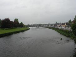
I set off quite late today, as we went into the centre of Dumfries so that I could visit Jessops to buy a few little bits and bobs. It was raining as we left, and that was how the rest of the day remained - wet, wet, wet. I started off by crossing the nice suspension bridge over the river in Dumfries, which is a lovely little structure that has been recently restored. Even in the drizzle the town looked lovely, and the red stonework of the town glinted in the rain.
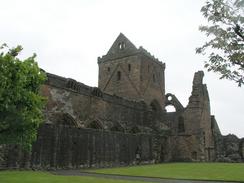
By the time that I reached New Abbey I was soaking wet, so it was a relief when I met Sam in Mervan by the dramatic remains of Sweetheart Barry, which dominates the village. The ruins are really quite impressive, and are well laid out with neatly cut lawns within the walls. Sweetheart Abbey is a Cistercian convent that was founded in 1273 by the wife of John Balliol, and when he died his wife had his heart removed and placed in an ivory casket, which was carried with her until she died. The casket was buried with her in the abbey. I decided to have a long lunch break to see if the rain would ease at all, and so we went to the Abbey Inn in the village for a drink. It turned out that this pub had free Internet access, so we spent a while checking emails (unfortunately I did not get time to respond to all of them, which is fairly typical). When we finally got back to Mervan it was still raining, and so I took my time eating my lunch before setting off into the drenching rain once more.
Towards the end of the walk I passed a small cottage that was the birthplace of John Paul Jones. Considering this is such a small cottage it has a surprisingly large car park and museum, which is because John Paul Jones is known as being the father of the American Navy. It is nice having got to his birthplace, as I have been following his exploits around the coast, from an attempted invasion with the French in Fishguard, to another attack on Whitehaven and the sinking of a British ship off Flamborough. All this came about because during the American war of independence John Paul Jones decided to take the battle to Britain. I did not have time to go around the museum, but I nipped in so I could pick up a leaflet from the exceedingly bored looking assistant.
We had arranged to meet mum and dad in Kippford, and so as soon as I finished the walk we drove to the village. We met them in a pub, where we had an absolutely superb meal and a lovely chat. After a couple of hours we left, having arranged to meet them again in a couple of days, and we then drove back to Southerness for the night. After we arrived we both fancied a drink, and so we went into one of the pubs, the Nineteenth Hole. This has a fairly strange six-sided pool table. Bu the time that I had my first drink I was fairly tired, so I retired and left Sam to play a couple of games on the table. I was well asleep by the time she got back, having forgotten that the licensing hours are quite different in Scotland!
Directions
This walk starts off at the car park by St Michael's Bridge, on the eastern bank of the river. Head northwards across the approach road to the bridge and continue on for a few yards, until a lovely suspension bridge over the river is reached. Turn left and cross the bridge onto the western side of the River Nith.
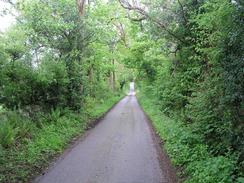
On the western side of the river turn left and follow a path southwards along the river. The path heads under an arch of St Michael's Bridge before continuing on, passing a cemetery and a sewage works before an aerial is reached. From here I joined a little track that headed southwestwards past some houses before ending at the A710 road. Turn left and head southwards along the A710 road, crossing a bridge over Cargen Pow and passing Islesteps. When a farm near Gilfoot is reached turn left to head southeastwards along a road, passing Woodside and reaching Kirkconnell. Here turn right and follow another road southwestwards, passion Drummillan and reaching a T-junction. Turn right and head westwards along another road for a short distance until it ends at the A710 once more. Turn left and head southwards along the A710, crossing the bridge over the New Abbey Pow and climbing up into the village of New Abbey.
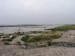
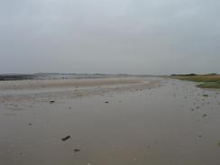
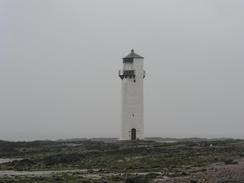
Pass Sweetheart Abbey and continue southeastwards and then southwards along the A710 road for about five miles until the village of Kirkbean is reached. In Kirkbean turn left down a road that heads eastwards close to the church, before heading out towards Carsethorn. The road crosses a little bridge over the Carse Pow and when a T-junction is reached before Carsethorn is reached, turn right to head southwards down another road. This passes Nethermill and then curves sharply to the right; immediately after this bend turn left to head southwards towards the farm at Tallowauharin. Pass the farm and continue on southwards down a track that heads through the grounds of Arbigland and passes Paul Jones Cottage before ending at a T-junction. Turn left to head southeastwards along a road for a little under a kilometre until a car park is reached near Powillimount. Drop down onto the beach and turn right to head southwestwards along the beach around Gillfoot Bay until the old lighthouse at Southerness Point is reached. At the lighthouse turn right to head inland until a car park is reached on the left, where this walk ends.
Distances
| From | To | Distance (m) | Ascent (ft) | Descent (ft) |
|---|---|---|---|---|
| Dumfries | New Abbey | 8.0 | 610 | 591 |
| New Abbey | Southerness | 10.1 | 427 | 456 |
This makes a total distance of 18.1 miles, with 1037 feet of ascent and 1047 feet of descent.
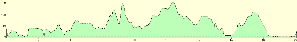
For more information on profiles, ascents and descents, see this page
Accommodation
We parked Mervan in a car park outside the Nineteenth Hole Pub, where there were some public toilets. This was a very quiet place to park, and was handy for two pubs.
Disclaimer
Please note that I take no responsibility for anything that may happen when following these directions. If you intend to follow this route, then please use the relevant maps and check the route out before you go out. As always when walking, use common sense and you should be fine.
If you find any information on any of these routes that is inaccurate, or you wish to add anything, then please email me.
All images on this site are © of the author. Any reproduction, retransmissions, or republication of all or part of any document found on this site is expressly prohibited, unless the author has explicitly granted its prior written consent to so reproduce, retransmit, or republish the material. All other rights reserved.
Although this site includes links providing convenient direct access to other Internet sites, I do not endorse, approve, certify or make warranties or representations as to the accuracy of the information on these sites.
And finally, enjoy your walking!
This walk was mentioned in the following routes:
| My walk around the coastline of Britain |
Nearby walks
| # | Title | Walk length (miles) |
|---|---|---|
| 443 | Powfoot to Dumfries | 19.9 |
|
|

|